Grey Mountain near Whitehorse, Yukon Territory, Canada (9-9-18)

Day 37 of Lupe’s 2018 Dingo Vacation to the Yukon, Northwest Territories & Alaska!

7:15 AM, 41°F, Tormented Valley, British Columbia – The rain had ended within an hour of when Lupe arrived last night, yet the morning dawned cool, breezy and still drearily overcast.  The higher peaks were scraping the clouds.  A brief light shower blew through.  Didn’t look much like rain, but the uniformly dull sky didn’t appear likely to improve, either.  Not a very nice day for Peak 6053.

A chilly, overcast morning in the Tormented Valley.

10:34 AM, 46°F – Waiting hadn’t helped, at least not enough.  Slightly warmer out, but otherwise little change.  Frustrating, but might as well admit defeat.  Peak 6053 wouldn’t be any fun under these conditions.  A year ago, Lupe had enjoyed a such fabulous day on the International Falls trail here that returning to climb nearby Peak 6053 had become a priority this year.  The American Dingo would have had an even more spectacular view of a sea of tremendous snowy peaks in Alaska!

Not happening.  Not today.  The G6 needed an oil change.  Should at least get that done, instead of letting the whole day go to waste.

11:44 AM, 54°F, Whitehorse, Yukon Territory – Brilliant!  An hour’s drive to Whitehorse only to realize that it was Sunday.  So much for getting an oil change.  The good news was that the weather was much better here than back in the Tormented Valley.  Blue skies, puffy clouds, less wind, and warmer.  Lupe could do something here, but what?

Surprisingly, the Whitehorse visitor center was open.  Loop waited in the G6, while SPHP went in.  SPHP wasn’t finding much of potential interest to a peakbagging Dingo until picking up a pamphlet entitled “Wildlife in Whitehorse”.  Inside were brief descriptions of 15 different locations in or around Whitehorse to see wildlife.  One in particular stood out:

14 – Grey (or Canyon) Mountain is the prominent landmark southeast of Whitehorse.  About 6 km up the Grey Mountain Road (off of Alesk Drive in Riverdale) a small viewpoint overlooks the Yukon River valley.  You may want to continue up the road by foot or mountain bike to the sub-alpine areas for a chance to see Dall Sheep or ptarmigan.  The road is not maintained beyond the viewpoint and is not suitable for vehicle travel.

Grey Mountain (4,901 ft.) sounded promising!  Maybe Lupe could get in a peakbagging success today after all?  A map on the reverse side of the pamphlet showed how to get there.

From the SS Klondike at the S end of downtown Whitehorse, go SE on the bridge over the Yukon River. Hang a L on Alsek Drive, and another one on Grey Mountain Road.

Grey Mountain Road was paved at first, but eventually turned to gravel.  It was fine for the 6 km mentioned in the pamphlet all the way to a big pullout on the R.  A map posted here showed an extensive trail system, including a summit trail that continued on from the end of Grey Mountain Road.  Sweet!

SPHP sort of expected to see the small viewpoint overlooking the Yukon River at this pullout, but maybe the trees had grown up enough to hide the view?  At any rate, it didn’t seem to be here.  This was probably the end of the maintained road, but the road continuing on past the pullout didn’t look that bad.  Since it was already afternoon, and still quite a long way to the end of Grey Mountain Road, SPHP drove on.

Yeah, this was the unmaintained road alright!  It quickly turned rough – deep potholes, large stones, and ridges of exposed bedrock.  No big deal in a high clearance vehicle, but pretty terrible for the G6.  Driving very slowly and carefully, SPHP navigated another km up the obstacle course to a little spot where the G6 could get off the road.  Upon parking here, the Carolina Dog immediately leapt out.

A moment later, she leapt back in.  Nope, Lupe wasn’t going to do this!

Why not?  Grey Mountain Road had gone past a shooting range before reaching the big pullout at the end of the maintained road.  Nothing makes intrepid explorer and adventurer Lupe as nervous as the sound of gunfire, no matter how distant.  Of course, she had heard some.

So SPHP got back in, and continued the ill-advised drive.  After getting quite a bit farther this time, SPHP parked at another little off-road spot.  Safety first!  Big Chicken still refused to get out.  SPHP finally caught her and physically dragged her out.  As soon as Loop realized she could no longer hear shooting, she was fine.

3:16 PM, 52°F – Lupe still had a good road hike ahead of her as she set off for Grey Mountain(4,901 ft.).  Heading SE along the mountainside, she passed through a forested gap, then arrived at a better part of the road where the mountain dropped off steeply to the S.

Grey Mountain Road isn’t bad here! Still a bit of a trek to the end, though. Photo looks SE.

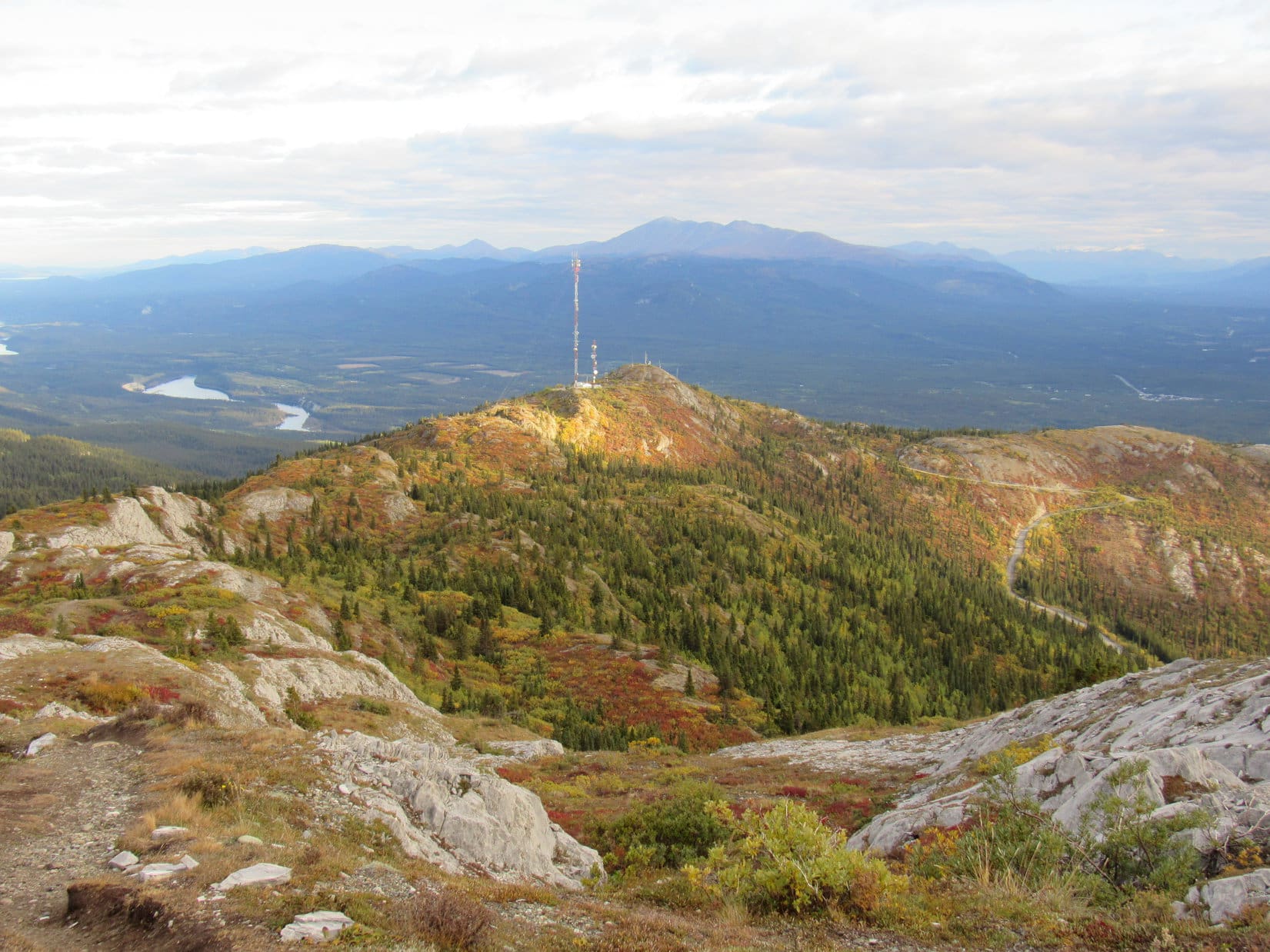
Rounding a corner, two towers came into view.  The road curved along the side of a big drainage, switchbacked higher, then curled around the S end of Grey Mountain before turning N.  Once up to the S end, Lupe had a grand view of the Yukon River valley all the way to Marsh Lake.

The road ends up at those towers (Center)!
At the S end of Grey Mountain. The Yukon River flows this way from Marsh Lake seen in the distance on the L. Mount Lorne (6,629 ft.) is on the R. Photo looks SE.

Grey Mountain Road climbed steeply shortly before ending at a parking area near the towers.  The towers were fenced off, but Lupe was free to get up on a big wooden platform nearby.

On the wooden platform near the towers at the end of Gray Mountain Road. Photo looks SSE.

Although the absolute summit wasn’t in view from the platform, Lupe could see Grey Mountain ahead to the NNW.  A trail was visible on the ridge leading to it.  Getting to Grey Mountain was going to be a cinch!

Grey Mountain from the wooden platform. The summit trail follows the ridge on the R. Photo looks NNW.

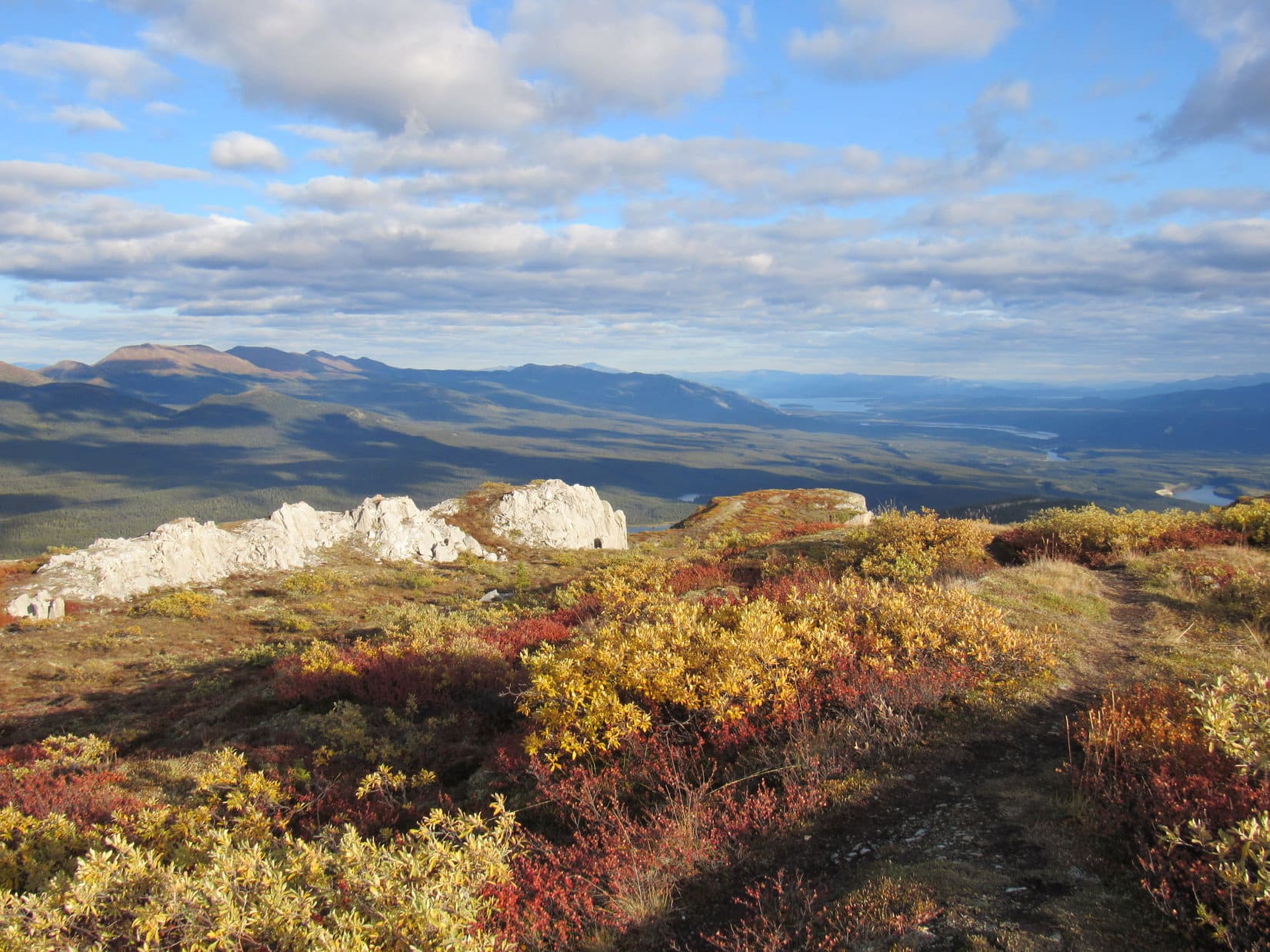
The journey along the ridge was gorgeous!  Beneath blue sky and white clouds, bushes blazed in the golds, oranges, and crimsons of autumn amid scattered deep green conifers and light grey rock.  The trail climbed at an easy to moderate pace with only a few steep sections.

The summit trail goes up Grey Mountain (L) from the R. Photo looks NNW.
Lupe gained 1,000 feet of elevation during her stroll up Grey Mountain Road. From the wooden platform near the towers, the summit of Grey Mountain is only another 700 feet higher.
Cantlie Lake. Photo looks E.
The early autumn colors were gorgeous!
Getting closer! The trail stays to the R here.
Looking back toward the towers. Mount Lorne (L) in the distance. Photo looks SSE.
Nearing the top! Photo looks NW.

When Lupe reached the high point visible from the wooden platform, she was at the S end of a large summit ridge.  This ridge was lumpy with many exposed light grey rock formations, and still rose gradually toward the N.  Low bushes and sparse tundra were present, but almost no trees grew up here, so Lupe already had tremendous views.

At the S end of Grey Mountain’s long, broad, lumpy summit ridge. Photo looks NNW.
Chadburn Lake (Center & R) from Grey Mountain. The lake on the L is actually part of the Yukon River. Photo looks SW.

Exploring N along the broad, lumpy ridge, Lupe searched for the true summit.  She often had a choice of trails to follow.  A succession of high points led to a survey marker with an arrow pointing toward one more high spot, the apparent true summit of Grey Mountain.

Continuing N looking for the summit.
The survey marker at the last high point before the true summit.
The true summit (Center) from close to the survey marker. Photo looks N.
Beautiful tundra.

Between the survey marker and the summit, Lupe came to a wide gash 40 or 50 feet deep that sliced across the entire ridge.  The sides of the gash were fairly steep, but the American Dingo had no problem getting across the gash to reach the top of Grey Mountain (4,901 ft.).

By the edge of the gash before crossing it. Photo looks E.
The NW end of the gash.
Looking WNW while climbing out of the gash.

The summit of Grey Mountain was a flat mini-ridge superimposed upon the rest of the mountain.  Metal bars stuck up out of the ground here, but Loop did not find another survey benchmark.  Low bushes grew around the perimeter of the mini-ridge, while the center was nearly barren.

On top of Grey Mountain. The gash Lupe had just crossed is on the R. Photo looks SE.
Exploring the mini summit ridge. Photo looks NNW.
Blending in with the golden bushes. Photo looks NNE.
At the high point. Photo looks SE.
Loopster looking pensive at the true summit of Grey Mountain.

SPHP congratulated Lupe on climbing Grey Mountain (4,901 ft.).  She gracefully accepted the praise, but what the Carolina Dog really wanted was protection!  She had been hearing gunfire again for a while now, and had been gently begging SPHP to comfort her.

Of course, sweet puppy!

At the top of Grey Mountain, SPHP sat facing SW with a panoramic view of a vast region of magnificent Yukon territory.  The air was getting a bit chilly again.  Wrapped in a purple pullover, Lupe curled up on SPHP’s lap to be loved and petted.

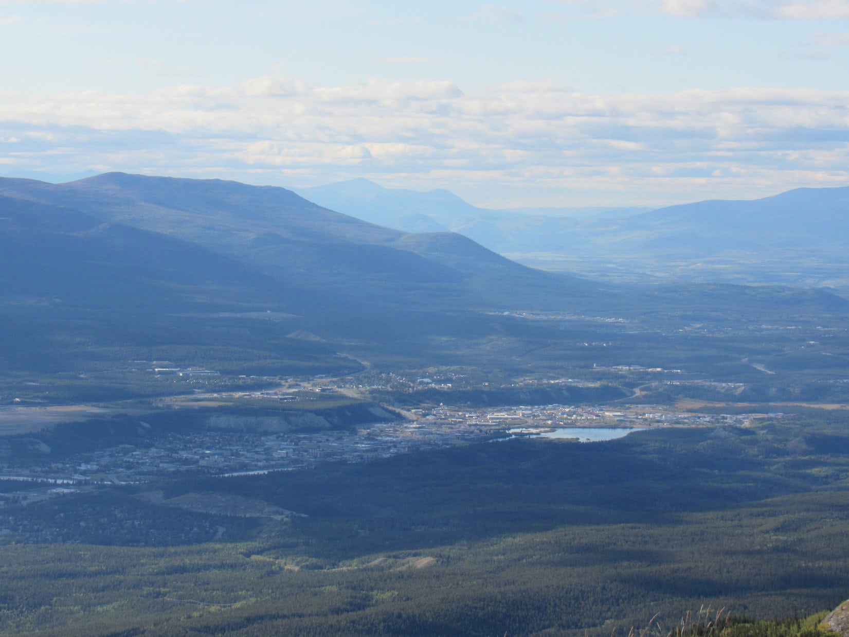
More than half an hour went by, during which Lupe gazed calmly upon splendid scenes.  Directly ahead to the SW, was a fabulous view of the mighty Yukon River valley.  Snowy peaks mostly hidden by clouds were far to the S.  Mount Lorne (6,229 ft.) was in the same general direction, but somewhat closer.  To the SE, the Yukon River stretched all the way to Marsh Lake on the horizon.

Looking back toward the gap Lupe had crossed to get to the summit of Grey Mountain. Mount Lorne in the distance on the L. Photo looks S.
Chadburn Lake and the Yukon River valley. Photo looks SW.
Marsh Lake (R of Center) in the distance. Yukon River valley (R). Photo looks SE.

Whitehorse, capitol city of the Yukon Territory, was off to the NW.  Cantlie Lake was back to the E.  To the NE were unknown mountains higher than Grey Mountain that looked like relatively easy climbs.

Whitehorse with help from the telephoto lens. Photo looks NW.
Higher peaks to the NE.

Clouds repeatedly cast Grey Mountain into shadow.  Even when Lupe was in sunshine, it wasn’t warm out.  Well into September now.  Time was running out on this Dingo Vacation.  Depending on the weather in the next day or two, it was possible Grey Mountain might be the last Yukon peak Lupe would ever climb.  Such a gloomy thought!

Lupe would have liked to stay even longer relaxing and enjoying the views.  She was right, so incredible here!  However, another mini-ridge was a little farther N beyond another smaller gash.  Since it looked close to being in contention for the title of true summit of Grey Mountain, the Carolina Dog really ought to go tag that high point, too.

The next mini-ridge to the N (Center) of where Lupe and SPHP had been relaxing. Photo looks N.

Getting over there took only a few minutes.  At about the highest spot, Looper found a collection of rocks.  A tumbled down cairn?  Maybe this actually was the true summit of Grey Mountain?  Admittedly a close call, but SPHP still thought the first mini-summit ridge was a bit higher.  Hardly mattered.  Lupe had been both places now.

At the possible tumbled down cairn at the high point of the N mini-ridge. SPHP still thought the true summit of Grey Mountain was on the first mini-ridge (R) Lupe had been to, but it was a close call. Photo looks SSE.

Lupe explored the second mini-ridge a bit farther N.  She didn’t get much beyond the wrecked cairn before the mountain began to drop away.  Clearly, nothing higher was ahead.  This was the end.

About as far N on Grey Mountain as Lupe went. Photo looks N.
Cantlie Lake with help from the telephoto lens. Marsh Lake (R) is in the distance. Photo looks SE.

The return trip was a beautiful, easy trek.  Lupe never did see any Dall sheep on Grey Mountain, but she did spot a ptarmigan.

The pamphlet was right! Lupe did see a ptarmigan on Grey Mountain.

All too soon, the towers at the end of Grey Mountain Road were in view again.

On the way back. Photo looks SE.
Approaching the towers. Part of Grey Mountain Road is seen on the R. Photo looks SSE.

The downhill road trek was pleasant enough, but couldn’t compare with being up on the trail.  Lupe was happy, though.  She was leading the way back to the G6, a bumpy return ride to the maintained road, and dinner.

Trudging along behind that curly tail in the shadow of the mountain, SPHP couldn’t help but think about what an unexpected and fabulous peak Grey Mountain had been.  The perfect end to what had begun as a dismal day!  (8:37 PM, 56°F)

Climbing Grey Mountain, Yukon Territory, Canada 9-9-18

Links:

Next Adventure                            Prior Adventure

Want more Lupe adventures?  Choose from Lupe’s 2018 Dingo Vacation to the Yukon, Northwest Territories & Alaska Adventure IndexDingo Vacations Adventure Index or Master Adventure Index.  Or subscribe free to new Lupe adventures.

Denali to Skagway – On the Road Again, Looking for Fun! (9-5-18 to 9-7-18)

Days 33-35 of Lupe’s 2018 Dingo Vacation to the Yukon, Northwest Territories & Alaska!

9-5-18, 8:04 AM, 39°F, Denali State Park – Blue skies!  An encouraging start.  Maybe today was the big day when Lupe would finally get to climb Reindeer Hills (5,102 ft.)?  Warming the G6 up a bit, SPHP drove NE on George Parks Highway No. 3.  During a quick stop at the Little Coal Creek trailhead (MP 163.9), Lupe stretched and sniffed around, while SPHP got ready for the Reindeer Hills.

A mile back, SPHP had driven past the Denali North viewpoint.  Better check that out before continuing on to the Reindeer Hills!

The Denali N viewpoint is at MP 162.9 of George Parks Highway No. 3. The Denali S viewpoint is at MP 135.2. Lupe had been to the S viewpoint a couple of days ago.

Any day an American Dingo gets to see Denali (20,310 ft.) is a great one!  Lupe had been to Denali State Park in both 2016 and 2017, but apart from a couple of brief partial glimpses, the highest mountain in North America had always remained hidden among the clouds.

However, today was a great day!  Gleaming white against the blue sky, Denali was out in the open, along with a host of other mighty peaks of the Alaska Range.

Denali looms far beyond mountains on the NW side of the Chulitna River valley. Photo looks WNW.
Jagged peaks of the Alaska Range. Photo looks WNW.
Incredible snowy peaks like these were mere foothills compared to Denali.

Lupe had already seen Denali from the South viewpoint a couple of days ago.  SPHP was of the opinion that the S viewpoint actually provided a better look at the monstrous mountain.

However, on the way to the Reindeer Hills, well out of Denali State Park along George Parks Highway No. 3, Lupe had even better views of Denali right from the highway.  Far more of the frozen giant was in sight.  Even from 45 miles away, the towering height and sheer massiveness of the world’s coldest mountain outside of Antarctica was incredible to behold!

Denali from George Parks Highway No. 3 NE of Denali State Park. Photo looks W with help from the telephoto lens.

Approaching Cantwell, the Reindeer Hills came into sight, mere blips in comparison with Denali, but nevertheless, an exciting and challenging peakbagging prospect for Lupe and SPHP.

Approaching the Reindeer Hills. Photo looks NE.

The key question was how to access the Reindeer Hills (5,102 ft.)?  At Cantwell, SPHP turned E on Denali Highway No. 8, which soon turned to gravel.  The high point of the Reindeer Hills is only a couple of miles N of the highway 6 or 7 miles E of Cantwell.  However, all through this area, the road stayed S of a heavily forested creek drainage.

Loop would have to battle through a lengthy stretch of trackless forest and bogs, crossing the unseen stream somewhere along the way, before reaching the lower slopes of the Reindeer Hills.  The prospect seemed daunting.  8 miles from Cantwell, SPHP parked the G6 by a lovely little lake on the S side of the highway.  Lupe got out for a look around, while SPHP paused to consider her options.

By the lovely pond 8 miles E of Cantwell. Photo looks SW.

Gazing at the Reindeer Hills high point, the mountain looked like an easy climb, if only Lupe could get to it!

Reindeer Hills high point from the parking area by the little lake. Photo looks NW.

Pondering the situation, getting across the hidden stream seemed to be the crucial issue.  The topo map showed the creek being closest to the highway a couple of miles back W where it joined a tributary of the Jack River.  W was sort of bad, though, because that was in the downstream direction.  Even before reaching the Jack River tributary, the stream would be bigger.  On the other paw, the stream was so close to the road there, it wouldn’t take Loop long to get to it.  She would find out very quickly if fording the creek was realistic or not.

May as well give it a shot!  SPHP drove back to the tributary of the Jack River, parking the G6 at a pullout on the SE side of the highway just N of the tributary.  Full of enthusiasm, the American Dingo hopped out to give it a go.  (9-5-18, 11:52 AM, 51°F)

Looking down the tributary of the Jack River right after it flows under Denali Highway No. 8. Photo looks WNW.
The Reindeer Hills high point (R of Center) from S of the tributary of the Jack River. The stream Looper needed to get across is hidden in the lowlands beyond her on the far side of the tributary. Photo looks NNE.

Lupe and SPHP headed N from the highway into a flat region densely covered with bushes.  The bushes were only a few feet high, but to Lupe, they formed practically an impenetrable jungle.  Although this area looked flat, before she made it very far, the terrain was pockmarked with holes full of water 2 or 3 feet deep.  Nevertheless, Loop managed to thrash through it all until she was roughly 300 feet from the highway, where she reached the S bank of the stream she needed to cross.

The stream was only a few feet wide, but fast-flowing.  The water was easily over Lupe’s head and SPHP’s knees, and perhaps deeper than that.  Hard to tell.  The tightly packed bushes along both banks made the prospect of getting into or out of the stream look troublesome at best.

SPHP didn’t like it.  Lupe might easily get swept downstream out of sight in the frigid waters of the powerful current.  Unable to touch bottom, what if she couldn’t escape the deep narrow channel?  SPHP wouldn’t be able to get to her in time to help her.

No, not worth it.  Maybe the confluence of this stream and the tributary of the Jack River would be an easier spot to cross?

Trying to get the confluence, Lupe fell into one of the waterholes among the bushes.  She managed to scramble out, cold and wet, but didn’t care for the experience.  Loopster wanted to head back to the highway.  She did, too.  All by herself.  SPHP could explore this morass alone!

SPHP had to plead with Looper to give it one more try.  Reluctantly, she did, but the confluence of the streams presented no better opportunity to cross.  Alright, forget about it!  Not happening!  The Carolina Dog was plenty happy to return to the G6.  (9-5-18, 12:21 AM, 51°F)

Much closer to Cantwell, a couple more possibilities were checked out where Lupe wouldn’t have had to cross any streams.  However, potential private property issues cropped up.  This area was miles from the high point of the Reindeer Hills, anyway.  Already afternoon, and too late in the day to consider an attempt, even if clean access had been found.

No Reindeer Hills!  Most disappointing.  What to do?  Seemed terrible to waste the rest of such a beautiful day, but after Loopster’s big trek up to Ermine Hill (2,700 ft.) and Peak 3700 on K’esugi Ridge yesterday, maybe a day of rest was a good thing.  The plan became to drive back to Palmer, where Loop could take on Matanuska Peak (6093 ft.) tomorrow.

Denali again from George Parks Highway No. 3 in the afternoon. Photo looks W with help from the telephoto lens.
Another look with even more help from the telephoto lens.

9-5-18, 7:57 PM, Wasilla –  Not even 8:00 PM, yet the sun hung low in the W.  The days were noticeably shorter now than a few weeks ago when the Most High Exalted Dingo of the Arctic Sisterhood had returned to the far N.  Kind of sad.  Lupe’s time in Alaska was running out.

9-6-18, 6:50 AM, Palmer – Surprisingly dark.  Only partially due to the changing season, though.  The sky was all a depressing gray.  The pointy summit of Matanuska Peak (6,093 ft.) was in view beneath the clouds, but perhaps not for much longer.  Within 10 minutes, a light rain set in.  Too bad.

Might as well face it.  Matanuska Peak wasn’t going to happen for Lupe, either.  Suddenly it was clear that the long road home had already begun when the Carolina Dog left the Reindeer Hills behind yesterday.  After stops at Fred Meyer’s for groceries and fuel, SPHP drove out of Palmer heading E on the Glenn Highway.  Lupe stared out the window of the G6 as the windshield wipers slapped away the rain, and the miles rolled by.

More than 3,000 miles to go!  Lupe’s adventures on this Dingo Vacation weren’t over yet.  She still had time, extra days she could spend along the way.  Surely, fabulous mountains were still to come.  A little cooperation from the weather was all it would take.  The American Dingo was merely on the road again, looking for fun!

9-6-18, 10:15 AM, 41°F, Gunsight Mountain trailhead – Forgetting about Matanuska Peak had been the right thing to do.  By the time Lupe made it to Gunsight Mountain (6,441 ft.), all was mist and fog.

At the Gunsight Mountain trailhead, MP 118.5 of the Glenn Highway.

Loopster had already climbed Gunsight Mountain in 2016, but nearby Syncline Mountain (5,471 ft.) was of interest, too.  Not for today, but in the hope that Lupe might return to Alaska someday, SPHP wanted to check out the Syncline Mountain access situation.  A map at the Gunsight Mountain trailhead showed possible access from Belanger Pass.

Map posted at the Gunsight Mountain trailhead.

Some sort of route to Belanger Pass left the Glenn Highway at MP 123.3, only 5 miles E of here.  Since it was on the way, Lupe and SPHP went to check it out.

At MP 123.3, a decent road left the N side of the highway.  SPHP drove a couple of miles along it before deciding to turn around at a giant mud hole that covered most of the road.  On the way out, a man was outside working on a deck for his summer home.  Lupe and SPHP stopped to chat with him.  He said the G6 could make it to a parking area about 3.5 miles shy of Belanger Pass.  A 4WD road went over the pass and 40 miles beyond it.

Interesting, and hopefully helpful on some future date.  SPHP thanked him for the information.  Lupe and SPHP then went on, but not before getting a photo of the spiffy sign this guy had posted along the road not far from his driveway.

On the road to Belanger Pass. Syncline Mountain is the long ridge in the fog. Easily amused, SPHP liked the sign. Photo looks NW.

9-6-18, 1:07 PM, 50°F, Copper River overlook – The journey E continued.  The miles rolled by.  Lupe didn’t escape the G6 again until she was at the Copper River overlook one mile E of Gakona Junction along the Tok Cut-off.  The sky remained dull and gray, but the rain and mist were over.

At the Copper River overlook a mile E of Gakona Junction.

Lupe and SPHP had often stopped here to see the magnificent view of the Copper River, but had always gone on after a few minutes.  Having been cooped up in the G6 for most of a day and a half, though, Loop was anxious for action.  A dirt road headed down into the river valley.  Never explored it before.  Maybe Lupe would enjoy a little romp to see what was down there?

Oh, yes!  Lupe heartily approved of this plan.  She raced ahead going back and forth checking trees for squirrels.

The road leading down from the bluffs to the Copper River.

After losing roughly 100 feet of elevation, the road curved sharply NE, then leveled out only a few feet higher than the river.  Lupe and SPHP continued along the road gaining vastly different impressions.

The hike was pleasant enough.  Both sides of the road were lined with trees and bushes.  However, since the road always remained 10 to 20 feet from the river’s edge, and the intervening strip of land was heavily wooded, SPHP was disappointed that the Copper River was never in sight.  Loopster, on the other paw, was thrilled!  The trees harbored a lively squirrel population.

What joy!  Everywhere she went, all up and down the road, Lupe found more squirrels to bark at.

This is the best idea you’ve had in a while now, SPHP!

One would think this road might eventually lead to river access at some point, but to Lupe’s great delight the road went on and on, never getting any closer or farther from the river.  Meanwhile, the woods provided a steady supply of squirrels that needed a good barking at.  That was fine for a while, but after 0.33 mile, SPHP insisted upon pushing through the narrow woodlands to the edge of the Copper River.

Hmm.  Water was way up against the bank, putting an end to any dreams of a stroll out on a nice long exposed stretch of riverbed.

Too bad you didn’t bring a raft, SPHP. That would have been quite an adventure! Lupe by the Copper River.

9-6-18, 8:30 PM, Donjek River, Yukon Territory – The Copper River had been the highlight of the day.  456 miles from where she’d left Palmer, Alaska this morning, Lupe arrived at another mighty river, the Donjek, in the Yukon Territory.  Clouds had spit rain on and off all day long.

There was a glorious mountain here S of the river.  SPHP had taken to calling it Donjek Crossing Mountain.  Ever since Lupe had first crossed the Donjek River in 2016, thought had been given to climbing it, but the weather hadn’t ever cooperated.  Wasn’t looking all that promising this evening, either, but who knew what the morning might bring?

In any case, stopping here for the night.  Going to give it a chance.  The Donjek River was very low.  As day turned to dusk, the Carolina Dog had a fabulous time wandering up and down exposed riverbed with SPHP.

Donjek Crossing Mountain beyond the Alaska Highway bridge over the Donjek River. Photo looks ENE.

9-7-18, 6:10 AM, Donjek River – Light out, but the news was as expected.  An hour and a half ago, it had been raining.  No rain now, but heavily overcast.  SPHP petted Lupe, and got an enthusiastic licking in return.  No huge rush, may as well sleep in a bit.  Not likely, but maybe the sky would clear?

9-7-18, 8:48 AM, Donjek River – No change.  Low ceiling.  Simply dismal.  Donjek Crossing Mountain, along with every other high point, was cloaked in clouds.  Otherwise nice enough out, but no point in climbing anything only to spend the whole day lost in a fog.

Lupe still managed to have a fun morning constitutional romp along the mighty Donjek River, though, before pressing on.

Even without being able to see the mountains, the Donjek River is still an impressive sight, isn’t it? Think of how enormous it must be during the spring snow melt! Photo looks SW.

The weather gradually improved on the road S.  By the time Loop got to Kluane Lake, patches of blue sky were visible off to the E.  However, the visitor center at the SW end was closed when she arrived.  A few miles farther, Lupe and SPHP stopped again at a big pullout at the far S end of the lake.

S shore of Kluane Lake. Photo looks N.

This pullout is a favorite spot.  Lupe had first been here in August, 2016 only a few months after an incredible change occurred.  In May, 2016, Kluane Lake’s principal water source was naturally diverted elsewhere.  Meltwaters from the Kaskawulsh Glacier broke through a former ice barrier, and completely changed course.  Instead of flowing N into the Slims River and Kluane Lake, the meltwaters now flowed E into the Kaskawulsh River.

This dramatic change had happened practically overnight.  Sadly, the water level in Kluane Lake has been dropping ever since.  The lake was still huge and beautiful, but noticeably lower again this year.  Lupe and SPHP spent a little while enjoying the lake, the mountain views, and a few rambunctious Dingo games.

Sheep Mountain (6,400 ft.) from Kluane Lake. Lupe had climbed Sheep Mountain in 2017. Photo looks NW.
Oh, I know! How about a game of chase?

Light rain fell in Whitehorse when SPHP stopped for supplies, although it had been merely cloudy on the way here from Kluane Lake.  The rain didn’t last, and by evening Lupe was back in Alaska!  With 2 big cruise ships in port, Skagway was busy.

The Most High Exalted Dingo of the Arctic Sisterhood dropped by the Arctic Brotherhood building, just to let them know they still have some competition.  Then she took a stroll down to see the cruise ships, before finishing up her tour with a sight-seeing drive out to Dyea.

Lupe visits the old Arctic Brotherhood building in Skagway, now a tourist information center.
The Most High Exalted Dingo of the Arctic Sisterhood returns! Lupe joined the Arctic Sisterhood when she climbed AB Mountain (5,036 ft.) near Skagway in 2017.
Checking out the cruise ships down by Taiya Inlet.
So, SPHP. When are you going to take me on one of these? Dingoes love luxury you know!

For 3 days now, Lupe had been mostly on the road, taking her fun in bits and pieces at short stops along the way.  Bigger opportunities for more than that hadn’t panned out.  However, with any luck, tomorrow that would change.  The Most High Exalted Dingo of the Arctic Circle would be hitting the trail to high adventure once again, right here in Skagway!

Links:

Next Adventure                           Prior Adventure

Sheep Mountain, Kluane National Park, Yukon Territory, Canada (8-13-17)

AB Mountain – Lupe Joins the Arctic Sisterhood!, Skagway, Alaska (8-7-17)

The New Arctic Brotherhood

Want more Lupe adventures?  Choose from Lupe’s 2018 Dingo Vacation to the Yukon, Northwest Territories & Alaska Adventure IndexDingo Vacations Adventure Index or Master Adventure Index.  Or subscribe free to new Lupe adventures.