
Day 38 of Lupe’s 2018 Dingo Vacation to the Yukon, Northwest Territories & Alaska!
Found it! Finally! No wonder it had taken so long. A the far S corner of Choutla Subdivision Road, a heavily shaded side road disappeared into the trees. 50 feet after the turn, partially hidden by vegetation, was the sign SPHP had been searching for – Blattas Point Road.
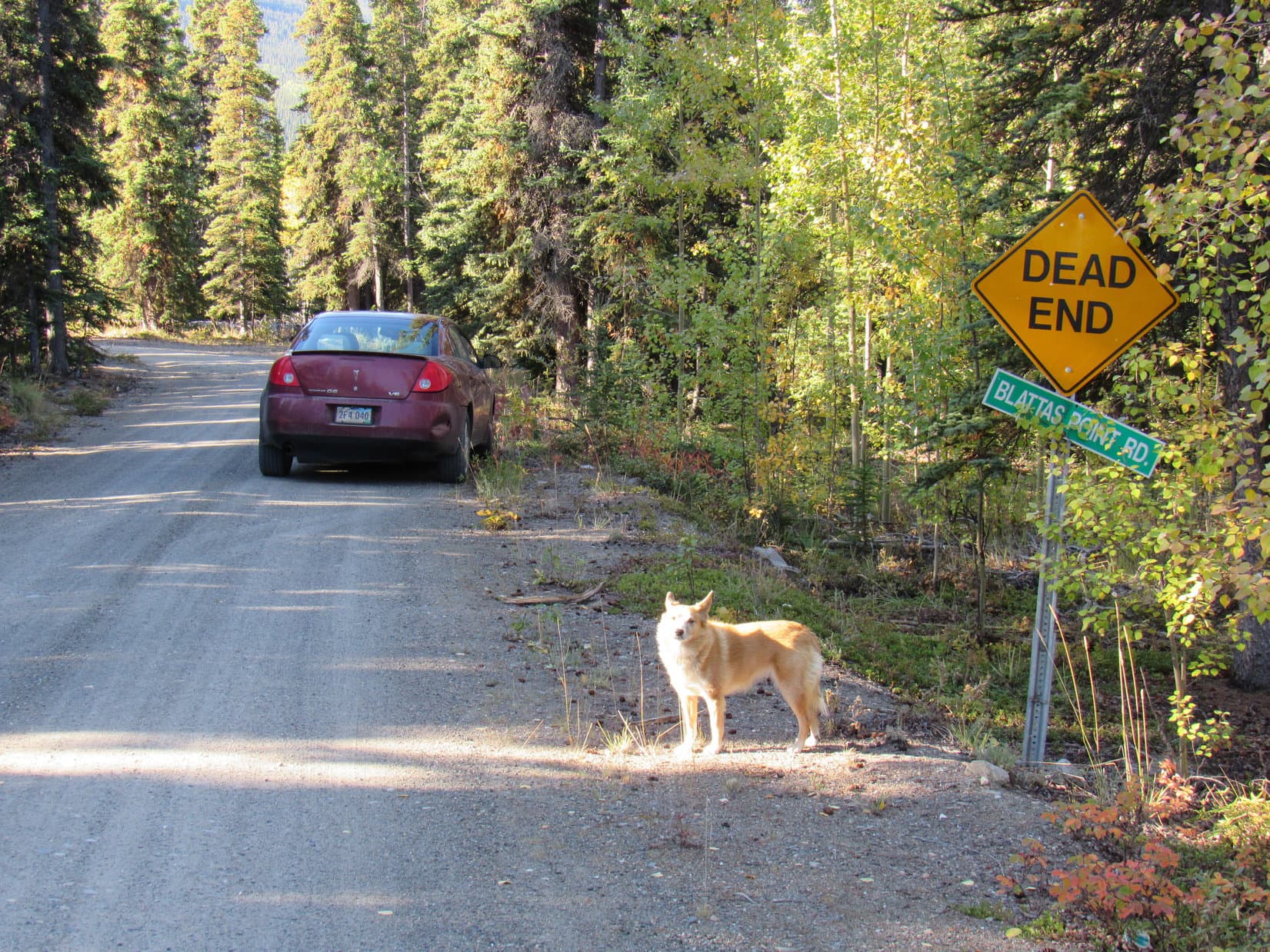
Beyond the elusive sign, Blattas Point Road curved SE (L) and continued in that general direction for a mile or so before ending at a small sandy parking lot. Two private driveways left this area, one that went straight ahead, and one that went to the R. SPHP parked the G6. This was it! Lupe had arrived at the trailhead for Nares Mountain (5,833 ft.).

What a fabulous day! For the first time on this whole Dingo Vacation, not a cloud in the sky. Incredible! Should have gotten here hours ago, but after Lupe’s tremendous day on Grey Mountain (4.901 ft.) near Whitehorse yesterday, SPHP had slept a little too well. An oil change for the G6, a few other errands, and the drive to Carcross had chewed up more time. Not to mention the maddening search for Blattas Point Road despite what had seemed to be perfectly clear directions.
The American Dingo was here now, though! A quick bite to eat, then Loopster and SPHP set off on an unmarked trail across from, and a bit beyond, the trailhead. (11:31 AM, 51°F)

The trail started off passing through stands of aspens that had already lost most of their leaves. Lupe was soon past the trees out on open ground. She hadn’t gained much elevation yet, but Carcross and the N end of Bennett Lake were already in sight beyond Nares Lake.


The trail initially climbed NE at an easy to moderate pace. However, it soon became steep, and stayed that way. Tight switchbacks helped to slightly reduce the rate of climb. Most of the time Lupe was out on open terrain, but she came to short stretches of forest, too. The Carolina Dog liked the woods best of all, but the views from the open ground became steadily more impressive as she rapidly gained elevation.


Two big ridges separated by a deep drainage lead up to the S summit of Nares Mountain from the W. The ridge farthest N was supposed to be the easiest route. The S ridge was closer to Nares Lake, but rougher and much more heavily forested.
Fortunately, the trail Lupe was on was clearly heading for the easier N ridge. When she got high enough, the Carolina Dog had a good view looking up the drainage separating the two ridges.


The steep climb went on and on. The views kept improving. The trail curved gradually E, and Lupe began to see more of the long W ridge she was climbing. She could now see where the two W ridges joined at the upper end of the drainage between them.


Loopster had already made tons of progress up the big ridge, when she finally got high enough to see several rounded high points off to the NE. The big ridge she was climbing was taking her to the S summit of Nares Mountain, but the true summit was actually one of those rounded high points. SPHP wasn’t certain which one was it, yet, but if the American Dingo had enough time, she was going to visit the true summit, too.

As Lupe approached the upper end of the drainage between the two W ridges, the slope of the ridge she was on gradually diminished. Getting easier! Still a long climb, but with a perfect day, the Carolina Dog was certainly going to make it at least as far as Nares Mountain’s S summit. The views were already awesome, and Looper ought to be able to see a lot more from up there.


Once Lupe made it beyond the upper end of the drainage between the 2 W ridges, the terrain flattened to a gentle slope. Across a grassy plain, one more rise was in sight off to the SE, a rock-strewn ridge certainly no more than another 100 feet higher. This ridge was an easy climb, and proved to be the S summit of Nares Mountain.

From a cairn at the high point, Lupe had some fantastic views. The true summit of Nares Mountain was in sight 2.5 km NNE. However, by far the most eye-catching scenes were of the big lakes to the E, S, and W, and of Montana Mountain (7,233 ft.) and Brute Mountain (7,000 ft.) to the SW.


Lupe had gained 3,300 feet of elevation. The American Dingo was ready for a break. With temperatures in the upper 40’s °F, the NW breeze felt chilly. SPHP wrapped Loop in a pullover, and she took a short nap.


Two somewhat lower high points on Nares Mountain were visible along ridges extending SE and SW from the S summit. Since these points were considerably closer to where the S face of Nares Mountain drops off steeply, presumably Lupe would be able to see much more of Nares and Tagish Lakes, if she went down to them.
When Loop was done with her rest break, she did go closer to each of these high points, although not close enough to get to the best possible views. Worried about Lupe’s late start, SPHP was becoming anxious to head on to the true summit of Nares Mountain instead.


After quick, sub-optimal forays to the SE and SW, Lupe returned briefly to the S summit of Nares Mountain. She then began her trek to the true summit by going NNE down to a flat grassy plain and crossing it. Upon reaching the N end of the plain, Loop faced a 600 foot descent into the broad saddle leading to the true summit of Nares Mountain.


The descent from the grassy plain down to the saddle was moderately steep and fairly rocky, but totally free of any significant obstacles. Lupe made it down to the saddle just fine, crossed it, and began climbing again. She skirted along the W side of the next big hill immediately S of the true summit. Goat paths helped make this traverse easier.
The Carolina Dog aimed for the saddle N of the hill she was on that led directly to the true summit. Once she made it to this upper saddle, all that was left was a 400 foot climb up the S face of Nares Mountain. No obstacles and nothing tricky to contend with. Lupe charged right on up the slope.
An hour and 20 minutes after leaving the S summit, Lupe reached the top of a 0.5 acre plateau. At the far N end, a cairn with a post marked the location of the true summit of Nares Mountain (5,833 ft.).


No longer on the protected S side of the mountain, the American Dingo immediately met with a 25 mph NW wind sweeping over the summit plateau. Couldn’t have been much more than 40°F, so the wind felt cold as Lupe headed over to the cairn. SPHP congratulated her on another fabulous peakbagging success as soon as she got there.


Lupe was no fan of the chilly wind, but a discovery soon made her forget all about it. A marmot lived at the top of Nares Mountain! Naturally, the Carolina Dog was keenly interested. However, the marmot had chosen its home wisely. Ensconced in a collection of dark-colored rocks, the marmot was monarch of a virtually impregnable fortress. Lupe kept sniffing, circling, and peering into the dark crevasses between the rocks, but to no avail.

SPHP tried to interest Lupe in the amazing views, repeatedly calling her away from the marmot fortress. The Carolina Dog did come, but as soon as SPHP’s attention was averted to some splendor on the horizon, she tended to slink back to continue searching for some weakness in the marmot’s defenses.


The summit plateau was roughly 0.25 to 0.50 an acre in size. The only notable features were the cairn and the marmot fortress. After a look at the views in all directions, Lupe and SPHP retreated slightly below the S rim to escape the wind. Resting here for a while, SPHP petted Lupe. Some of the very best views from Nares Mountain were on display.


Nearly 50 minutes shot by up on Nares Mountain. The sun was sinking. Lupe returned to the summit cairn once more. She felt compelled to stop by the marmot fortress again, too, to see if the marmot was ready to come out and play. However, the marmot told Loop she’d have to take a rain check on that, even though it wasn’t raining.


The return trip was such a marvelous time! As evening shadows began to lengthen, autumn colors glowed in the sunlight. Incredible sweeping views every step of the way! Lupe didn’t have to, but she climbed back to the S summit of Nares Mountain for a final look. Back to the NNE, the true summit was still brightly lit beneath the blue Yukon sky.


Then it was down the long northernmost W ridge at an ever steepening pace, facing the glorious view of Carcross, Nares and Bennett Lakes, and Mount Gray as the sun slid toward a phalanx of western peaks. Later in the darkening woods, and on down the tight switchbacks, the sense of airiness melted away.
Nares Mountain was destined to be the last Yukon peak Lupe would climb on this Dingo Vacation, but one more fabulous peak remained. Half an hour away, in far NW British Columbia, was a mountain on the edge of Alaska, one the American Dingo had been close to several times on this trip, but conditions had never been right for it.
Back at the trailhead, tired and hungry, Lupe gobbled her Alpo. Stars overhead! The sky was still 80 to 90% clear! Nares Mountain had been a fantastic day, and tomorrow was full of promise, too. (9:30 PM, 53°F)

Directions to the Nares Mountain trailhead – From Carcross go 2 km NE on Tagish Road (Hwy 8) watching for a sign for Choutla Subdivision on the R near the top of a small rise. A km from the highway, Choutla Road makes a rectangular loop. Blattas Point Road heads SW into the trees at the far S corner opposite from where the loop begins, the Blattas Point Road sign being hidden 50 feet in after already on it. Follow Blattas Point Road 2 km to the very end at 2 private driveways. Park in a small parking area on the R. No signs or amenities.
Links:
Next Adventure Prior Adventure
Want more Lupe adventures? Choose from Lupe’s 2018 Dingo Vacation to the Yukon, Northwest Territories & Alaska Adventure Index, Dingo Vacations Adventure Index or Master Adventure Index. Or subscribe free to new Lupe adventures.