
Day 14 of Lupe’s 2017 Dingo Vacation to the Yukon & Alaska!
Yesterday evening, after a couple of peakbagging adventures on overcast days, Lupe and SPHP had driven N out of Haines, Alaska back into Yukon Territory looking for sunnier skies. By nightfall Loop had made it as far as Dezadeash Lake. Although there were patches of blue sky this morning, clouds still prevailed. Before continuing N, the Carolina Dog spent a few minutes stretching and sniffing around.


After a short morning romp, Lupe and SPHP proceeded N on Haines Highway No. 7 to the Alaska Highway at Haines Junction. Although Dezadeash Lake was big, Lupe’s next stop farther N along the Alaska Highway was at a much larger lake, beautiful Kluane Lake E of Kluane National Park & Reserve.

Lupe had been to Kluane Lake on her 2016 Dingo Vacation to the Canadian Rockies, Yukon & Alaska, too. A big gravel parking lot at the S end of Kluane Lake right off the Alaska Highway was a favorite spot. Lupe could see her next peakbagging goal, Sheep Mountain (6,400 ft.), right across the bay.

The Sheep Creek trail providing access to Sheep Mountain was closed due to grizzly bear activity, when Lupe had been here in 2016. SPHP stopped by the Tachal Dahl visitor center to check on the status today. The American Dingo was in luck! Not only was the Sheep Creek trail open, but park personnel were recommending it.
SPHP returned to the G6 with the good news that Loopster had a green light on Sheep Mountain. The Slims West trailhead was nearby, only a short drive W from the Alaska Highway along the base of the mountain. Soon Loop and SPHP were leaving the trailhead parking area heading SW on the Slims River West trail. (10:45 AM, 60°F)

The Slims River West trail begins as an easy stroll along an abandoned roadbed. In 10 minutes, Lupe reached a turn NW onto the Sheep Creek trail. A map was posted nearby, in addition to a plaque commemorating a hiker killed by a grizzly in July, 1996.

The Sheep Creek trail headed NW into a forest. The trail was very wide and well worn. Lupe was soon climbing steadily. Although clouds were floating this way out of the SW, the drive N had been successful in finding sunshine at Kluane Lake. Uphill exertion made it feel plenty warm out. Squirrels provided occasional excitement and reason for happy Dingo barkfests.
A fine powdery dust covered the whole Sheep Creek trail. Puffs of dust poofed up with each pawstep, as though Looper were traveling through a desert. The trail might be named after Sheep Creek, but there was absolutely no water. Loop seldom saw or even heard Sheep Creek, which was soon hundreds of feet lower in a canyon to the SW. Lupe would have been better off as an Arabian Dingo, storing water in a hump on her back. Fortunately, as long as SPHP was around packing in a water supply, Lupe wouldn’t have to change her nationality.
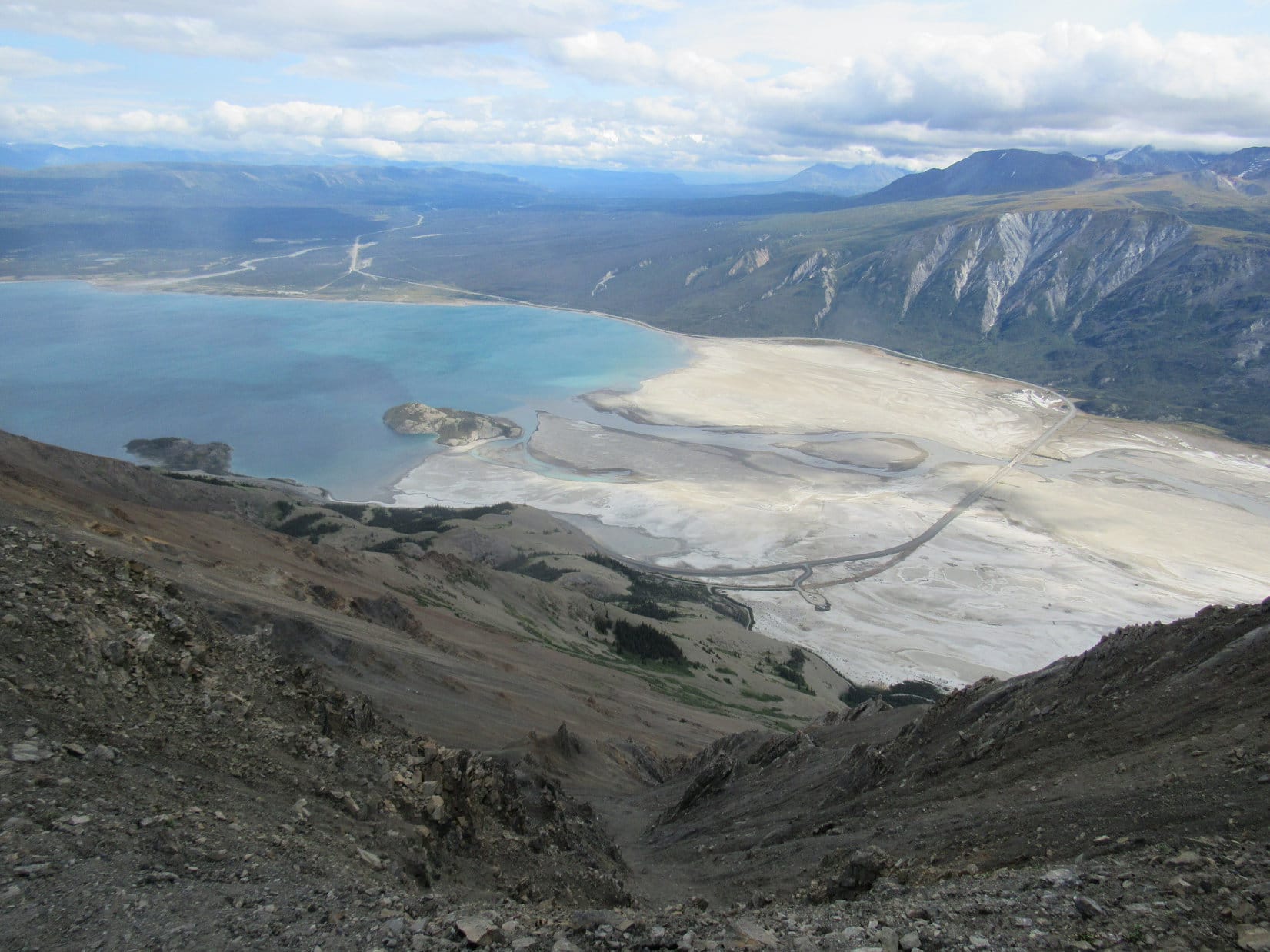
The Sheep Creek trail was an uphill trudge, devoid of views until Lupe was getting close to the 2 km mark. She could now see SSW up the Slims River valley. And oh yeah, there was Sheep Creek, way the heck down there!


The trail seldom stopped climbing, though some stretches were steeper than others, as Lupe journeyed onward. She was still in forest most of the time, but it was starting to thin out. Viewpoints were becoming more frequent. Of course, the higher the Carolina Dog went, the better the views were getting.


Lupe passed signs marking the 2 km and 3.8 km points along the trail. Beyond the 3.8 km marker, the Sheep Creek trail narrowed down to a good single track. Trees became scarce. The mountainside was now covered in bushes.
The last trail marker came at the 5 km point. This was the official end of the Sheep Creek trail. From here, Lupe could see all the way S up the Slims River valley to the toe of the Kaskawulsh Glacier. The glacier was so far away, it was difficult to be certain Lupe was really seeing it. Only by using the telephoto lens on the camera was it possible to tell for sure. Binoculars would have been a tremendous help.


Although Lupe had reached the official end of the Sheep Creek trail, she had a lot farther to go, if she wanted to climb Sheep Mountain. The long NW ridge coming down from the SW end of the mountain was in view from here. This ridge is on the S side of the Fortyeight Pup Creek drainage. Lupe would have to climb it.

From the end of the Sheep Creek trail, an unmaintained “Ridge” trail continues E around the N side of a hill covered with bushes. As Lupe rounded the hill, she could see that this trail really was going to take her to the start of the ridge she needed to climb.

The climb up the NW ridge leading to the SW end of Sheep Mountain was long, but not difficult. The steepest part was at the beginning. The Ridge trail helped make the ascent easier, and wasn’t hard to follow. It was just a matter of having sufficient heart, leg and lung power to keep going. As usual, Lupe had plenty of all three, while SPHP lagged behind.
Despite SPHP’s frequent stops to catch breath, Lupe was making good progress up the ridge. She soon had a beautiful view of Red Castle Ridge back toward the Bullion Plateau area. Loop could also see the summit of Sheep Mountain beyond the end of the Fortyeight Pup Creek drainage, though SPHP didn’t recognize as such yet.


Lupe loved being in the alpine on the big open ridge! None of it was the least bit scary. No large rock formations, boulders, scree or talus fields appeared. No cliffs or steep drop offs existed. The ridge was always plenty wide. The only mildly discouraging factor was a series of false summits, but they couldn’t go on forever.
Clouds sailed overhead out of the SW. Sometimes it was windy; most of the time it wasn’t. From the end of the Sheep Creek trail up to the first viewpoint from the SW end of Sheep Mountain’s main ridge, the Ridge trail was 2.5 km long. Of course, Loop had amazing views all the way up the barren ridge, too.


Beyond the last of the false summits, the already broad ridge widened out even more. Only very short sparse vegetation existed up here. The Ridge trail all but disappeared, but there was never any question on which way to go.

Finally the trek up the long ridge was over. Lupe reached the high point at the far SW end of Sheep Mountain. Here there was need for a little caution and presence of mind. Tremendous cliffs existed all along the SE edge of the mountain.
The views were incredible! For the first time, Lupe could see the entire length of the Slim River valley all the way from mountains beyond the toe of the Kaskawulsh glacier clear down to the Alaska Highway and Kluane Lake.


Lupe and SPHP were taking a break on the high point at the SW end of Sheep Mountain, when suddenly there were voices. A couple appeared coming up the Ridge trail. They turned out to be from Whitehorse, and had a rangefinder with them. They quickly spotted several herds of Dahl sheep grazing on a mountainside beyond the Fortyeight Pup Creek drainage. The sheep were so far away, Lupe hadn’t even noticed them.
SPHP chatted with the couple from Whitehorse. Loopster relaxed and enjoyed being petted. This viewpoint was as far as the couple intended to go. They had no interest in continuing on to the true summit. By the time they started back down, more than 30 minutes had shot by.
Lupe had better get going! The true summit was still some distance away. Although it wasn’t much higher than where Loop was now, she would have to lose then regain a fair amount of elevation to get there.


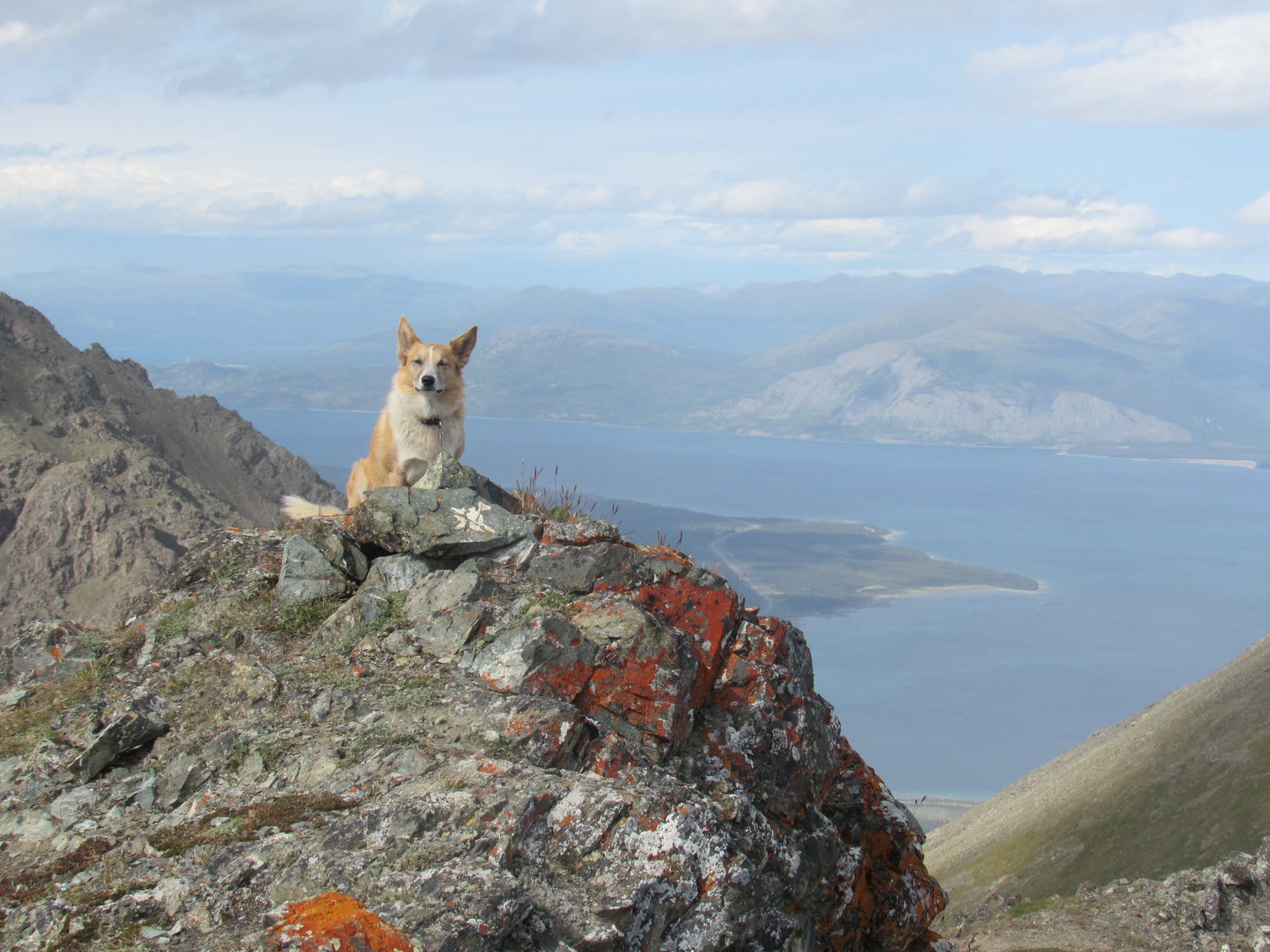
The first elevation drop leaving the high point at the SW end of Sheep Mountain was by far the biggest. Lupe subsequently came to a number of other high points and smaller drops along the way, too. However, the trek along Sheep Mountain’s main ridgeline was a dream, such a treat! The views of Kluane Lake were simply stupendous!


As Lupe proceeded NE along the ridgeline, she now began noticing herds of Dahl sheep. That really perked the Carolina Dog up. She was keenly interested in sheep! The Dahl sheep were grazing in alpine meadows on both sides of Sheep Mountain (6,400 ft.), but all were far, far below Looper’s lofty position up on the main ridge. None of the sheep had the slightest idea that such a ferocious predator as an American Dingo was eyeing them greedily from above. Eh, they were so far away, they had no cause for alarm.
Lupe finally reached the highest ridge toward the NE end of Sheep Mountain where the true summit is located. More than 50 minutes had gone by since she’d left the SW high point. The true summit was now an easy stroll to the N. Loopster could already see more of Kluane Lake, and also had a great view of High Point 6378 (1944 m on the topo map).


The true summit of Sheep Mountain (6,400 ft.) was at the N end of the summit ridge. Lupe trotted on over to claim her peakbagging success! For a mountain with over 4,000 feet of elevation gain (including some of the extra elevation regained traipsing along the main ridgeline) Sheep Mountain had been easy, super fun, and a visual treasure.


Lupe spent half an hour at the top of Sheep Mountain. SPHP passed the time gazing upon the glorious 360° views, while Loop concentrated on monitoring the tiny white specks far below that were herds of Dahl sheep. Sheep Mountain had something for everyone!


The American Dingo and SPHP would gladly have stayed up on Sheep Mountain much longer, but the weather was beginning to deteriorate. Blue sky was disappearing. An endless procession of gray clouds was steadily approaching from the direction of the Slim River valley.
Probably best to be moving on. Sad, but true.

Lupe wasn’t eager to be torn away from watching Dahl sheep, but she would see more of them on the trek back along the main ridgeline to the SW high point. Before setting out, Looper took one more look down on the Slims River valley and Kluane Lake from the S end of the summit ridge.


While still on the main ridge, a rain shower hit. Fortunately, it didn’t rain hard, and didn’t last long. Lupe and SPHP pressed on. More rain showers were threatening. However, Lupe did stop briefly when she reached Sheep Mountain’s SW high point again.


Rain threatened again, but never did catch up with Lupe. On the way down the long NW ridge from the SW high point, Looper had a blast! It was windy out, and the breeze made her half wild. She ran all over the place sniffing and exploring.
Back on the Sheep Creek trail, the fun continued when the Carolina Dog found squirrels to bark at in the trees. Many times she showed off how fast she was for SPHP, racing up and down the dusty trail kicking up clouds of dust as if she were the Roadrunner. SPHP praised her for her boundless energy and great enthusiasm.
And that was it. Lupe’s marvelous Sheep Mountain adventure was over. (8:32 PM, 59°F) Evening found her at the S end of Kluane Lake.

Of course, Sheep Mountain was in view right across the bay. Sheep Mountain had been a great adventure, a superb day! Only a few hours ago, Lupe had been up there, way up at the top.
Only a light breeze blew down here. Kluane Lake was a gently rippling inland sea. Everything was blue and white and silver and gray. A dark blue procession of seldom visited, mysterious peaks marched endlessly N, far beyond Kluane Lake, forever on their way to the Arctic.
Tomorrow Lupe would be on her way there, too.

Related Links:
Kings Throne, Kluane National Park, Yukon Territory, Canada (8-7-16)
Decoeli, Kluane National Park, Yukon Territory, Canada (8-9-16)
Want more Lupe adventures? Choose from Lupe’s 2017 Dingo Vacation to the Yukon & Alaska Adventure Index, Dingo Vacations Adventure Index or Master Adventure Index. Or subscribe free to new Lupe adventures.