Day 7 of Lupe’s 2017 Dingo Vacation to the Yukon & Alaska!
(5:20 AM, Summit Lake, Stone Mountain Provincial Park, British Columbia) Sometime during the night, the evening’s steady rain quit. Now it was light out, but a dense fog hid everything. Lupe sawed wood peacefully under her blankie, still weary from two long days of mountain climbing.
Can you lick yourself dry? Apparently you can. Loop had done it. The Carolina Dog was toasty warm and felt completely dry, despite having returned to the G6 cold, drenched, and starving after yesterday’s crazy adventures on Mount Saint George(7,402 ft.).
No need to wonder what to do today. A day of rest was in order. A nice long drive, most of it cruising W across southern Yukon Territory was on tap. Should be a fun, relaxing day with plenty of opportunities for quick stops at beautiful places along the Alaska Highway.
SPHP turned the key. The G6 sprang to life. Headlights on, SPHP drove carefully down the slick, wet highway. Summit Pass, the dense fog, and Lupe’s grand adventures in Stone Mountain Provincial Park were left behind. The American Dingo was awake and alert now, not wanting to miss a thing (5:42 AM).
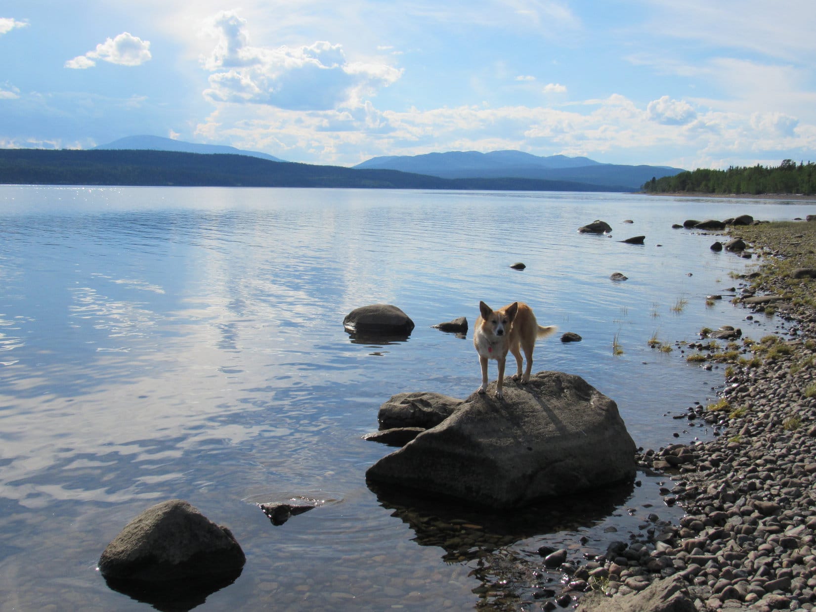
Lupe and SPHP were still in British Columbia. Loopster would have plenty to do and see before she even got to the Yukon. Her first stop was at a pullout along the Alaska Highway right before the bridge over the Racing River. Lupe had stopped here briefly on her way home last year, too. She’d been delighted to find a beautiful short walk along a grassy road hidden in the woods near the river. There were dispersed camping sites, squirrels in the trees, and at the end of the road, a viewpoint next to the gorgeous river.
Not a soul was around. The squirrels were still here. Lupe had a blast! The woods rang with the shrill joy of an enthusiastic Dingo. Only the sky and the river had changed. Last year Loop had been here in September. The Racing River had been a stunning icy blue on a mostly sunny day. Now the river was swollen with silt, a murky light gray color matching the somber sky.
Lupe at a silty, light gray Racing River. 11 months ago the river had been a gorgeous icy blue. Photo looks upstream (SW).The Racing River wasn’t as pretty as last year, but Lupe had a blast barking at squirrels in the woods on the short walk to this viewpoint. Photo looks downstream (NE).
Loop’s next stop was at a pullout with a view of the Toad River reached shortly after entering Muncho Lake Provincial Park. The Toad River wasn’t as silty as the Racing River, but still only offered a hint of the fabulous icy blue color both it and the Racing River had been when Lupe was here in 2016.
The Alaska Highway winds up the Toad River valley in Muncho Lake Provincial Park.Looking across the Toad River at a big alluvial fan.
Lupe made two more stops in Muncho Lake Provincial Park. Since the Alaska Highway passes right along the E shore of Muncho Lake, her next break from the G6 was to take a good look at the gorgeous lake itself.
Muncho Lake sits in a pass high in the Muskwa Range. The Alaska Highway follows the E shore of the lake. Photo looks N.A gorgeous snow-capped peak sits beyond Muncho Lake in the direction this photo is looking. Lupe had seen it last year, but today it’s hidden by clouds. Photo looks SSW.
Lupe’s final stop along Muncho Lake was at the impressive Northern Rockies Lodge, which seems to be the center of activity in Muncho Lake Provincial Park.
The Northern Rockies Lodge on the E shore of Muncho Lake is right off the Alaska Highway, and seems to be the hub of most activity in Muncho Lake Provincial Park.Lupe drops by the Northern Rockies Lodge in Muncho Lake Provincial Park. She wasn’t an official guest, so she didn’t get to go in, but she would have liked to. It looked luxurious, and American Dingoes love both adventure and luxury!
Lupe wasn’t an official guest at the Northern Rockies Lodge, so she didn’t get to go inside to check it out. She most definitely liked the looks of it, though, and would have gladly gone in, if SPHP hadn’t been such a cheapskate and had booked her a room. SPHP wasn’t an official guest, either, but did sneak in to pick up a brochure about flight-seeing tours.
The bush pilot flight-seeing tour to Victoria Falls in Nahanni National Park, one of the largest waterfalls in Canada, sounded absolutely spectacular! The float plane leaves right from Muncho Lake at the Northern Rockies Lodge. The tour alone was a measly $750 Canadian, and accommodations at the fabulous Northern Rockies Lodge could be included in a package deal for a little more. Loopster was all for it!
SPHP muttered something about not being in the budget, an unknown price per Dingo, and unkindly made Lupe’s disappointment even worse by taking her down to see the very float plane she might have soared off to visit Virginia Falls in.
Following the lure of the North, that was exactly what Lupe was here for!Oh, yeah! Here was the very float plane Lupe might have soared off to Victoria Falls in!
Lupe didn’t get to fly to Victoria Falls, but then SPHP didn’t either, so at least it was fair. However, at the next stop along the Alaska Highway at Liard River Hot Springs Provincial Park, SPHP had all the fun.
Lupe arrives at Liard River Hot Springs Provincial Park in NE British Columbia.
It wasn’t fair at all that SPHP got to enjoy Liard River Hot Springs and Lupe didn’t, but it really wasn’t SPHP’s fault. Signs made it clear Dingoes were prohibited. Poor Looper couldn’t even take the boardwalk leading to the hot springs for a look around.
It was sort of OK. Loopster was still pretty bushed from her mountain climbing adventures the past two days. An hour’s snooze curled up in the G6 didn’t sound all bad. Besides, it had been awhile, and SPHP would return from the hot springs all fresh and clean as a sweeter-smelling more tolerable traveling companion. SPHP promised not to be gone too long. (8:48 AM, 57°F)
SPHP returned a little more than an hour later sniffing better, warm and relaxed. For only a $5 day-use fee, Liard River Hot Springs had been really unique and a great experience. SPHP was careful not to make it sound too wonderful, though, so Loop wouldn’t get jealous again.
At Liard River Hot Springs bathers follow this long boardwalk to get to the actual hot springs. The Liard River is some distance away (on the other side of the Alaska Highway actually) and not in view.The boardwalk starts out crossing a natural warm water swamp.The warm water swamp often attracts wildlife, but SPHP saw none today. On the bright side, there weren’t any mosquitoes either.Once beyond the swamp, the boardwalk goes through a boreal spruce forest.The boardwalk leads to a changing house next to the hot springs. There are separate rooms for the two sexes with benches and hooks, but no lights, electricity, heat, lockers or running water.Liard River Hot Springs is a totally outdoor experience in a natural lush boreal spruce forest setting. So unique and beautiful!The hot springs are divided into two sections. This is the upper section where the water has been dammed up a bit. It is only a few feet deep. The water is hottest here, coming from a very hot spring entering this pool at the far end.This is the lower, cooler downstream pool. It’s only a few feet deep, too. It is not dammed up and drains naturally into a creek at the far end. Choose whatever water temperature you like! The water cools rapidly the farther downstream you go. Like it really hot? Stick with the upper pool.A view of both pools and the transition between them. Beyond the far end of the upper pool, a boardwalk going L leads to a short trail to the “hanging gardens” which were closed this day due to bear activity. A boardwalk to the R leads directly to a nice outhouse style restroom.The hot springs enter the upper pool here on the opposite bank. The boardwalk to the hanging gardens trail is in view.Looking back at Liard River Hot Springs from the start of the short boardwalk to the rest rooms. What an awesome wilderness setting! For a $5 day-use fee, you can soak in the hot springs all day if you like. Such a bargain!Heading back all warm and clean to check on Lupe. There’s a picnic ground and campground at the parking lot, too. Gates close nightly until morning, so don’t stay too late unless you intend to camp!
Once done at Liard River Hot Springs, Lupe and SPHP returned to the Alaska Highway (10:33 AM). There wouldn’t be any more long stops during the day, but Lupe would have plenty of brief opportunities to stretch her legs. Most of the time, the G6 purred its way W.
There were moments of frenzied Dingo excitement!
That crazy little Dingo could make all the racket she wanted to. If anyone was going to do any intimidating, it was this guy.Along many miles of the Alaska Highway from Muncho Lake Provincial Park to close to Watson Lake, the forest is clear cut far back from the road on both sides. Buffalo like to graze in the resulting adjacent fields. Elsewhere, forests extend to the horizon.
Lupe saw the big gray-green Liard River.
Loop stopped to admire the beautiful Liard River that the hot springs are named after.Arising in the Pelly Mountains of SE Yukon, the Liard River flows 693 miles through the Yukon, British Columbia, and Northwest Territories. It’s a tributary of the Mackenzie River, which ultimately flows N to the Arctic Ocean at the Beaufort Sea.
Lupe left British Columbia, entering Yukon Territory before arriving in the small town of Watson Lake. As she continued W, the Alaska Highway sometimes curved back into British Columbia for a while, but most of the time Lupe was in the Yukon. She saw many beautiful peaks along the way.
On the drive W across the southern Yukon, Lupe saw many beautiful peaks from the Alaska Highway.
Although there was lots to see on the long drive, eternal vigilance wasn’t a strict requirement.
Loop enjoys a bit of peakbagging recovery therapy.
By afternoon, the sky was no longer completely overcast. The day warmed up considerably, hitting 84°F at one point. Sunlight highlighted beauty everywhere. SPHP stopped at a picnic ground near the Morley River. Lupe had high hopes at first, but didn’t care for it in the end. Too many biting flies, bees and mosquitoes. Not enough squirrels. SPHP ate and managed to dry out some wet clothing on the G6 before hitting the road again.
Late in the afternoon, Lupe came to huge Teslin Lake.
Late afternoon found Lupe at Teslin Lake.Teslin Lake is many miles long, but relatively narrow. The Alaska Highway follows the NE shore along the N half of the lake. Photo looks NW.
W of Teslin Lake, Lupe and SPHP finally left the Alaska Highway at Jake’s Corner, continuing W on Hwy No. 8. After crossing a long bridge over the Tagish River, SPHP pulled into a parking lot along the W bank. Apparently there are recreational facilities in this area. Lupe quickly discovered a boat ramp, and could see people around.
Lupe at a boat ramp on the W bank of the Tagish River. Photo looks ENE.
The Tagish River flows N into Marsh Lake. The American Dingo went up on the long bridge over the river for a look at the S end of the lake. The Yukon River flows out of the N end of Marsh Lake, but Looper couldn’t see it from here.
The S end of Marsh Lake from the Highway No. 8 bridge over the Tagish River. The Yukon River flows out of the N end of Tagish Lake, but Loop couldn’t see it from here. Photo looks N with help from the telephoto lens.
It was evening when Lupe reached Carcross, a small picturesque village. This was Sunday, so there weren’t many people around. All the tourist shops were closed, except for one restaurant where all the action was at the moment.
Lupe and SPHP took a stroll around Carcross just window shopping. SPHP said window shopping was well within budget. Loopster could window shop to her heart’s content! Most of the shops contained artwork or jewelry of one type or another. The buildings themselves were works of art!
Lupe enjoyed a window shopping extravaganza in Carcross! That SPHP sure knows how to show a Dingo a good time!A Carcross style killer whale was on display.Artwork and jewelry were central themes in Carcross. Even the shop buildings were works of art!
Window shopping was a nice change of pace. Lupe was soon satisfied with what she hadn’t bought. It was time to move on. Lupe and SPHP headed S from Carcross on the South Klondike Highway No. 2.
South Klondike Highway No. 2 passed along the W shore of two long mountain lakes. First came Tagish Lake. Lupe and SPHP stopped at a pullout to see Bove Island.
Lupe and SPHP stopped at a pullout along Highway No. 2 SE of Carcross where placards touted this view of Bove Island (L) in Tagish Lake. The forest had grown up so much Bove Island was actually only in view from a couple of specific spots. Photo looks NE.
Next up was Tutshi Lake. By the time Lupe reached Tutshi Lake, she had crossed back over the border into British Columbia again.
Tutshi Lake from Highway No. 2 S of Carcross. Lupe was back in British Columbia here. Photo looks S.
The sun was low when Lupe reached a strange land S of Tutshi Lake. The valley South Klondike Highway No. 2 was passing through widened out a great deal forming a broad basin. Mountains surrounded this relatively level, but roughly rumpled, basin at a distance. Vegetation was scarce. Trees were sparsely distributed. There seemed to be very little soil, and not much of the loose, broken rock typically seen in mountainous terrain.
Low hills having the appearance of exposed bedrock stretched across the basin among a network of numerous odd-shaped lakes of varying sizes. The sides of the mountains surrounding this weird land all appeared to be exposed bedrock to a level far above the basin floor.
The sun was getting low when Lupe left the G6 S of Tutshi Lake to investigate this very strange land. Bedrock seemed to be exposed almost everywhere, very little loose rock or soil was evident, vegetation was sparse, and a network of many odd-shaped lakes of varying sizes existed among low hills of solid rock. Photo looks E.Got it figured out yet, SPHP?
What an odd place! What had made it this way? This basin was unlike anything Lupe and SPHP had ever seen before. At least that’s how it seemed at first. SPHP thought for a while. A light finally went on. No, that wasn’t really true. Lupe had seen this sort of thing before, but never on such a grand scale.
Eons ago, this basin must have been buried beneath a massive glacier of gigantic proportions. Before it melted away, the glacier had scrapped the soil away down to bedrock. The glacier had been thousands of feet deep, so that even the mountainsides had been scraped clear of loose debris to a great height. Yes, that must be the explanation. It all made sense now.
The Carolina Dog seemed satisfied with this hypothesis. A day or two later, while window shopping again in Skagway, she would eventually see a poster of this unusual territory. The poster billed this region as the “Tormented Valley”, apparently a popular stop on sight-seeing tours between Skagway and Carcross.
Looking SSW across part of the Tormented Valley.
Lupe and SPHP continued S on Highway No. 2 passing Canadian Customs located along the W edge of the Tormented Valley. The highway left the Tormented valley going up over a hill at White Pass, before beginning a long descent into a tremendous, steep, V-shaped valley. This made sense, too. This sharp valley must have been eroded out by a once torrential river fed by the meltwaters of the ancient glacier.
Before she had lost too much elevation, Lupe passed through US customs. She had reached Alaska! Then it was down, down, down the deep, impressive valley. When it all ended, Lupe was practically at sea level. She had arrived in Skagway, Alaska.
Though the sun was long down and twilight had already faded to a considerable degree, Lupe and SPHP took an hour long stroll through Skagway. Perhaps it was only because it was sort of late on a Sunday night, but Skagway struck SPHP as a queer place. However, Lupe seemed happy enough with it. Perhaps she was simply glad to be out of the G6 again for a while, even if no one in this town except SPHP paid the least bit of attention to her.
Skagway seemed possessed of virtually no modern buildings, not even a gas station or a hotel. There was almost no traffic. The dim deserted business section was all touristy shops with an old-fashioned look to them. Posted prices reflected Skagway’s reputation as a famous tourist destination. Window shopping would be the order of the day here, too.
But everything was closed and dark, except for a few restaurants and bars. Even they were virtually empty and quiet. No crowds anywhere. A few people were out walking about in small groups of 2 or 3 engaged in low conversation. Occasionally someone shot by on a bicycle or skateboard. Everyone was young. The smell of dope rose from small gatherings seated outside old houses.
I don’t know what I was expecting of Skagway, Looper, but this wasn’t it. This joint is practically a ghost town. Wonder how you get to the ocean? Seems like it ought to be easy to find.
Oh, it’s over that way, SPHP. I can smell it. Can’t be too far. Skagway seems fine to me. What were you expecting, anyway?
Something newer, brighter, livelier, I guess. I suppose that’s all on the cruise ships. That’s how most everyone gets here you know. No doubt that’s why there’s so little traffic and no place to stay. Everyone’s on the ships. Looks like Skagway is still selling the gold rush days with all these old timey buildings.
Gold rush! What’s wrong with that? Maybe we’ll strike it rich!
Oh, nothing. Nothing at all. Except Skagway’s gold rush has been over for a long time. It’s interesting history, but we’re too late to strike it rich. Where is everyone, anyway? It’s summer! Aren’t there any cruise ships in port tonight? I didn’t expect they’d be rolling up the sidewalks at sundown here. Skagway is famous! Why, even I’d heard of it.
It’s Sunday night! Maybe tomorrow will be different?
Perhaps so, Loop. We’ll know soon enough. Doesn’t really matter if it isn’t except for one thing.
What’s that?
There better be a gas station around here somewhere. It’s a long walk to Whitehorse.
In the Tormented Valley, British Columbia, Canada on the way to Skagway, Alaska. 8-6-17
Day 6 of Lupe’s 2017 Dingo Vacation to the Yukon & Alaska!
(5:21 AM, Summit Lake at Summit Pass, Stone Mountain Provincial Park) The second time SPHP woke up sunlight was just beginning to shine on Mount Saint George. The light quickly grew in intensity. In minutes, the mountain was aglow, radiantly beautiful all pink and yellow. SPHP knew it wouldn’t last long, but couldn’t muster the energy to grab the camera until it was too late. The moment had passed.
Yesterday, up on Mount Saint Paul, Lupe and SPHP had been all excited about her success there, and eagerly looking forward to climbing Mount Saint George today. But by the time it was over, yesterday had been a nearly 13 hour expedition in rugged territory, and had taken a toll. SPHP felt it. Apparently Lupe did, too. She was awake, but all bleary-eyed. Clearly, “ambition” wasn’t her middle name this morning.
Huh? … Another mountain? … NOW!? You can’t be serious! For pity sake, just hit the snooze button, would ya, SPHP? I’ll think about it later.
For several minutes Lupe licked SPHP affectionately, as if to apologize for not wanting to dash off up the next mountain at the crack of dawn. It turned out she was hungry. She devoured a chicken treat, a milk bone, a generous bowl of Taste of the Wild, and lapped up a huge drink of water before rolling over to resume snoozing.
Clouds moved in. Mount Saint George vanished. It started to rain. Shucks! If it didn’t show signs of clearing up before SPHP’s breakfast was over, it would make more sense to drive on instead of sitting around here. Lupe still had a long way to go to get to where she had more adventures planned in the Yukon and Alaska. Still, it would be a pity not to even get an attempt on Mount Saint George in. If only yesterday’s beautiful weather had held out one more day!
Nothing one can do about that. It was what it was. A wind came up. It rained harder. SPHP piddled around to see what would happen. Breakfast, catch up the trip journal, get water at the campground, pitch out the trash, straighten out the G6, study a few maps. At 8:00 AM, the moment of truth arrived.
The breeze had died down. The rain had stopped. The sky remained overcast, but not darkly. Mount Saint George still couldn’t be seen. Maybe it would clear up? Prospects seemed 50/50. Lupe had been awake for a while now, looking no worse for yesterday’s wear. The Carolina Dog was ready for action again. Was it worth it, or was it smarter to drive on? Decisions, decisions.
Kind of now or never, Loopster. What do you think? Who knows if we will ever be back here again? We’re a mighty long way from home already.
Oh, I’ll be fine either way, SPHP. Yesterday was great fun, so I’m happy enough with an easy day watching scenery from the G6 if you want to drive on. On the other paw, I’d be happy to climb Mount Saint George now, too, if you’d like. Even if you don’t get your precious views, I always enjoy sniffing around and a good romp.
Hmm. Not that helpful, Looper. You’re as wishy-washy as I am.
Well, tell me what the weather is going to do, and I’ll tell you what to do.
I was hoping with your keen Dingo senses you knew. I can’t tell what’s going to happen. Maybe it’s best to delay making a final decision? We could start for Mount Saint George, but if the weather doesn’t clear up by the time we reach where the Flower Springs Lake trail leaves the road to the microwave tower, we could try going to Flower Springs Lake instead. If the weather gets all socked in and it starts to rain again, we can just beat a retreat and drive on.
Fine with me, SPHP! So are we going then?
Thus went the discussion, with no real resolution until 8:15 AM when at the edge of vision far to the W, the deciding factor appeared. A tiny speck of blue, blue sky. Hope blossomed. Maybe the weather really was going to clear? Maybe an hour from now, Lupe would be in brilliant sunshine? That blue speck was enough. Mount Saint George(7,402 ft.) was a go!
Lupe and SPHP crossed a paw bridge at the Summit Lake stream outlet which was where a sign at the campground indicated the Flower Springs Lake trail began. Immediately across the bridge, the trail divided three ways. No sign here. Left, right or straight?
Lupe tried going R along the shore of Summit Lake. She quickly came to places where the trail had collapsed into the lake. This couldn’t be right, could it? Perhaps this wasn’t even a real trail? (Note: Consulting maps later on, SPHP discovered this really was the Flower Springs Lake trail.) Loop returned to the junction by the bridge. This time she tried the middle trail which went up a hillside into the forest.
After Loop had gained some elevation, a small sign said she was on the Ridge trail. Appropriately enough, it climbed to the top of a ridge where it leveled out. The Ridge trail now passed through a forest dense with bushes. Everything was wet from the earlier rain. The bushes soon had Loopster sopping wet, too. She was one soggy doggie, but her spirits weren’t dampened in the least.
The Ridge trail wasn’t terribly long. After crossing the ridge, it led down a forested embankment to meet up with a road. SPHP knew this road led to a microwave tower perched on a hill at the base of Mount Saint George. Somewhere along the way the road ought to provide Lupe a convenient access point to the mountain. The American Dingo followed the road SSW going uphill.
A bit of a trek brought Lupe to a sign identifying the Flower Springs Lake trail where it crossed the road. This area was open terrain, the forest having recently been left behind. The sky was still overcast, but the speck of blue sky to the W had grown considerably. A W breeze held promise that the clouds might soon sail off to the E. With this encouragement, all thought of settling for the Flower Springs Lake trail was banished. On to Mount Saint George!
Shortly after passing the Flower Springs Lake trail, the road made a big switchback climbing W before leveling out. Lupe was now headed straight W toward the microwave tower, which could be seen atop its hill, High Point 5469 (1,667 m), more than a mile away. To the S, seemingly right at the base of Mount Saint George(7,402 ft.), a green 200 foot high ridge paralleled the road.
Lupe followed the road W halfway to the microwave tower before SPHP decided she might just as well begin her ascent of Mount Saint George. Lupe left the road and climbed S up onto the big green ridge.
Looking W at the microwave tower on High Point 5469 (1,667 m). This tower sits close to the N base of Mount Saint George. Lupe left the road here, turning S (L) to climb a 200 foot high green ridge that parallels the road.
Up on the green ridge, Lupe and SPHP stopped briefly to rest. Looking back, part of Summit Lake where Lupe had started from was in view. The Carolina Dog had already gained many hundreds of feet of elevation. Beyond the lake Looper could see Summit Peak(6,611 ft.). Only yesterday, Lupe had stood on top of Summit Peak on her way to Mount Saint Paul(6,985 ft.).
Up on the big green ridge looking back at where Lupe had come from. She’d started out at the far end of Summit Lake (R) which appeared to be many hundreds of feet below where she was now. Summit Peak, which she had climbed yesterday, is the more distant mountain at Center. Photo looks NE.
Lupe continued SW across the green ridge, which was very wide, toward the base of Mount Saint George. At first, heading right on up the wide NE arm of the mountain looked like it would be a snap. As Lupe got closer, though, it became apparent this was an illusion. A deep valley draining to the SE was between the American Dingo and the mountain.
Loop crossing the big green ridge toward the base of Mount Saint George. It initially looked like Lupe ought to be able to head straight for the NE arm of the mountain (Center), but she soon discovered a deep intervening valley draining to the SE (L). Photo looks SSW.
Dang it all, anyway! SPHP didn’t feel like descending into that deep, steep-sided drainage. A glance to the W revealed that the highest part of the drainage was way over near the microwave tower. Climbing onto this big green ridge had been a waste of time. Lupe should have just stuck with the road until she was at the base of the hill the tower sits on. It would have been faster and easier to turn S there.
A glance to the W revealed that the high point of the drainage Lupe needed to get across was way over by the microwave tower. It would have been easier to simply stick with the road instead of climbing up onto this big green ridge. Photo looks W.
Live and learn. Lupe and SPHP turned W traveling along the ridge toward the microwave tower. This pleasant level stroll was made even easier by an old jeep trail Loop found on the way. As Lupe started getting closer to the tower, she left the jeep trail angling SW to look for a good route down into the drainage.
As Lupe started getting close to the microwave tower, she angled toward the S side of the ridge she was on looking for a way across the drainage. The bottom of the drainage is in view now on the R. Mount Saint George has 3 N arms or ridges. The NE arm Lupe would ultimately go up is on the L. The middle N arm that ends closer to the microwave tower is seen on the R. Look at those beautiful blue skies now! Oh, yeah! Things were looking good. Photo looks SW.
Mount Saint George has three N arms or ridges. A large valley comes down between the middle and NE ridges that joins the drainage Lupe needed to get across only a little E of that drainage’s high point. As Lupe drew closer, she could see a sizable gash at the lower end of this valley.
That gash looked like a good spot to begin Lupe’s ascent of Mount Saint George. Once opposite the gash, the bottom of the intervening drainage wasn’t all that far below the green ridge, and the slope leading down into it wasn’t so steep. Lupe and SPHP descended into the drainage, and crossed over to the gash.
Looking across the drainage at the gash at the lower end of the valley between Mount Saint George’s middle N and NE ridges. The middle N ridge is on the R. Photo looks SW.Lupe on her way down into the drainage. It wasn’t far or steep to the bottom from here. The microwave tower is in view at the far end of the green ridge. Photo looks W.
As expected, the terrain in the eroded gash was nearly all rock. A stream so small it could be conveniently crossed almost anywhere tumbled down a series of small waterfalls into pretty pools below. Lupe explored numerous nooks and crannies while SPHP trudged up the gash.
Lupe wades the small stream in the gash. Part of the big green ridge she had just come from can be seen on the L. Photo looks NE.Looking up the gash. Although it was often fairly steep, traveling up the gash wasn’t bad at all. It certainly wasn’t as hard as it might have been. Most of the rocks were fairly small. Usually there were easy ways to avoid troublesome spots. Photo looks SSW.
After crossing the stream once, Lupe and SPHP stayed on the E (L) side of the gash the rest of the way up. The water in the creek was cold and clear. SPHP tried it. Delicious! The water SPHP had gotten from a pump back at the Summit Lake campground this morning tasted terrible. SPHP dumped it all to fill 3 water bottles with fresh creek water.
At the upper end of the gash, Lupe discovered a lovely waterfall higher than any of the others. It plunged noisily over a tilted layer of rock.
Lupe discovers the highest waterfall of all at the upper end of the gash. Photo looks S.The terrain above this waterfall at the upper end of the gash was not so heavily eroded. The stream raced swiftly and smoothly over intact layers of exposed bedrock. Photo looks SW.
Above the final waterfall, Lupe followed the creek quite a distance. Here it raced swiftly and smoothly over intact exposed layers of bedrock. Nearby slopes were mostly green with low vegetation. Gradually the creek bent around toward due S.
Lupe eventually left the creek to turn E toward Mount Saint George’s huge NE ridge. Loop aimed for a large black rock prominent among whiter stones high up along the ridgeline. A considerably lower black rock provided an intermediate goal.
Surprisingly, Looper found a narrow, but very definite trail that passed only a short distance below the lower black rock. The trail continued climbing ENE from here slanting up along the side of the ridge. Lupe reached the ridgeline somewhat below the upper black rock, which was now hidden from view.
Lupe was now on the lower slopes of Mount Saint George’s NE ridge. Way down here, the ridge was rounded and extremely broad. Small rocks interspersed with low vegetation dominated the terrain. Up until a short time ago, a W breeze had prevailed, driving the cloud cover off to the E, and bringing blue sky and sunshine.
The wind was shifting, however. A light E breeze was now forcing clouds back this way. Summit Peak was almost completely hidden from view, and Summit Lake was disappearing fast.
By the time Lupe reached the lower slopes of Mount Saint George’s NE ridge, the breeze had shifted around to the E. Clouds that had earlier blown off to the E were on their way back. Only an outline of Summit Peak is now visible beyond Summit Lake, which is also rapidly disappearing from view. Photo looks NE.
Despite the approaching clouds, Lupe and SPHP turned S and began climbing the vast ridge. The breeze might easily shift again, and Lupe had already come a long way. The Carolina Dog wasn’t going to give up on Mount Saint George so easily! Clouds enveloped the ridge. Everything except the immediately surrounding terrain disappeared.
Although clouds moved in to envelop the NE ridge, Lupe continued up.
For a long way, Lupe and SPHP continued up the NE ridge in fog. At least initially, the climb wasn’t as steep as Lupe’s ascents of Summit Peak and Mount Saint Paul yesterday. Sometimes Looper even came to relatively level stretches.
Slowly, though, the situation changed. The rocks increased in size. Vegetation became scarce. The terrain grew rougher and steeper. Lupe was climbing sharp boulder fields. In places, SPHP was scrambling instead of walking. The ridge was clearly narrowing, though it was still broad.
Lupe takes a break at a rare patch of greenery.
Lupe climbed a series of 100+ foot high benches of jumbled, broken rock. SPHP had to use hand holds. At the top of each bench, the terrain ahead usually leveled out some and became easier to traverse, but another bench every bit as difficult as the last one always appeared ahead.
Up and up went the Carolina Dog, over one obstacle after another. Time passed. It seemed like Lupe had been at this a long time. She must have gained a lot of elevation. Hard to tell how much, though. The fog might be distorting all sense of time and distance.
The fog was sometimes dark and thick. If it had stayed that way long, it absolutely would have been time to give up on Mount Saint George and head down. It didn’t though. After a few minutes, it would lighten up again. The fog swept in waves over the ridge. And every now and then, if Lupe looked up, the gray was tinged with blue. Maybe Lupe would climb above the clouds?
And then it happened. A genuine patch of clear blue sky appeared directly overhead. Lupe was in sunshine! It didn’t last. The fog reasserted itself. The hole closed. Lupe kept climbing.
More and more often, there were hints that Lupe was going to get above the clouds, or that they might simply blow away. The fog grew lighter and darker with increasing frequency. Blue tinged fog was seen more often overhead. In the meantime, the terrain was getting easier. The rocks were much smaller again. Lupe seemed to be past the boulder fields and benches. SPHP could walk instead of scramble. Lung, heart and leg power were the limiting factors instead of broken boulder fields.
Finally, finally, a bigger hole in the fog. Blue sky! Lupe could see farther up the ridge. The view was disheartening. SPHP had thought she would be closer to the top. The truth was, the American Dingo still had a long way to go.
Finally a genuine break in the clouds revealed much more of the ridge ahead. The sight was initially disheartening. Lupe still had a lot farther to go than SPHP had hoped. Photo looks S.
Puppy ho! Onward! Yes, it was still a long climb, but so what? The terrain wasn’t bad, steep yes, but not terribly so. This was cake! Just a matter of one paw after another. Lupe could get to the top of this NE ridge. No obstacle was in sight that could stop her.
Clouds and fog continued to sweep by sporadically, but less and less often. Lupe pushed on. She was going to reach the top of Mount Saint George’s NE ridge in brilliant sunshine!
The persevering puppy approaches the top of Mount Saint George’s NE ridge in brilliant sunshine! Not far now! Photo looks WSW.
Suddenly Lupe was there! She had reached the N end of Mount Saint George’s summit ridge where the middle N and NE ridges meet. This was the high point of both of those ridges. The views were incredible!
Looking NW, Loop could see the huge McDonald Creek valley. To the W, beautiful silvery mountains stood in sunshine. Off to the E and S was an amazing sight. A soft ocean of purest white stretched beyond vision. The ocean wasn’t much lower than where Lupe stood now.
From the N end of Mount Saint George’s summit ridge, Lupe could see all the way down to the bottom of the McDonald Creek valley (L). Photo looks NW.Looking W. Silvery mountains stand in sunshine beyond the McDonald Creek valley.To the E, an amazing sight greets Lupe. A soft, billowing ocean of white stretches beyond vision. The ocean isn’t much lower than where Lupe stands now on Mount Saint George. Photo looks NE.Looking S at the sea of white being held back by the mountains.What an amazing view! Dark blue mountaintops jut up like islands from the pure white ocean of cloud. It was like being in an airplane! Photo looks S.
One view was of greater importance than any other. Lupe had made it to the N end of Mount Saint George’s summit ridge, but this was the lower end. Not an awful lot lower, no more than 56 meters (184 ft.), relative peanuts compared to how far she’d come, but certainly enough to make a difference. Lupe couldn’t claim a peakbagging success yet. Unfortunately, the topo map showed the true summit was somewhere way over near the far SW end of the long ridge. How hard would it be for Lupe to get there?
The whole summit ridge was in view now. What Lupe saw was disconcerting. It appeared she could travel safely a long way, but near the SW end of the ridge where the summit was, the rock turned dark and it looked dicey. Really dicey. It looked like Looper might encounter drop offs or walls of rock she couldn’t climb or go around due to virtual cliffs next to the ridgeline.
On a brighter note, Lupe could almost certainly reach a high point about halfway along the ridge that looked higher than anything else except the summit. According to the topo map, High Point 7320 (2,231 m) was only 82 feet (25 m) lower than the true summit. Not really close enough to claim a peakbagging success, but still a major accomplishment on a day like today.
Lupe at the lower N end of Mount Saint George’s summit ridge. The view toward the true summit at the far end was disconcerting. It wasn’t at all clear that Lupe would be able to get there. She could probably make it to High Point 7320 (2,231 m) (seen straight up from Lupe’s head), though. It was only 82 feet (25 m) lower than the true summit according to the topo map. Photo looks SW.True summit of Mount Saint George (R). Photo looks SW with lots of help from the telephoto lens.
The true summit was too far away to tell for certain from here if Lupe would be able to climb it or not. After a short rest dazzled by the views at the N end of the summit ridge, Lupe and SPHP headed for High Point 7320 (2,231 m).
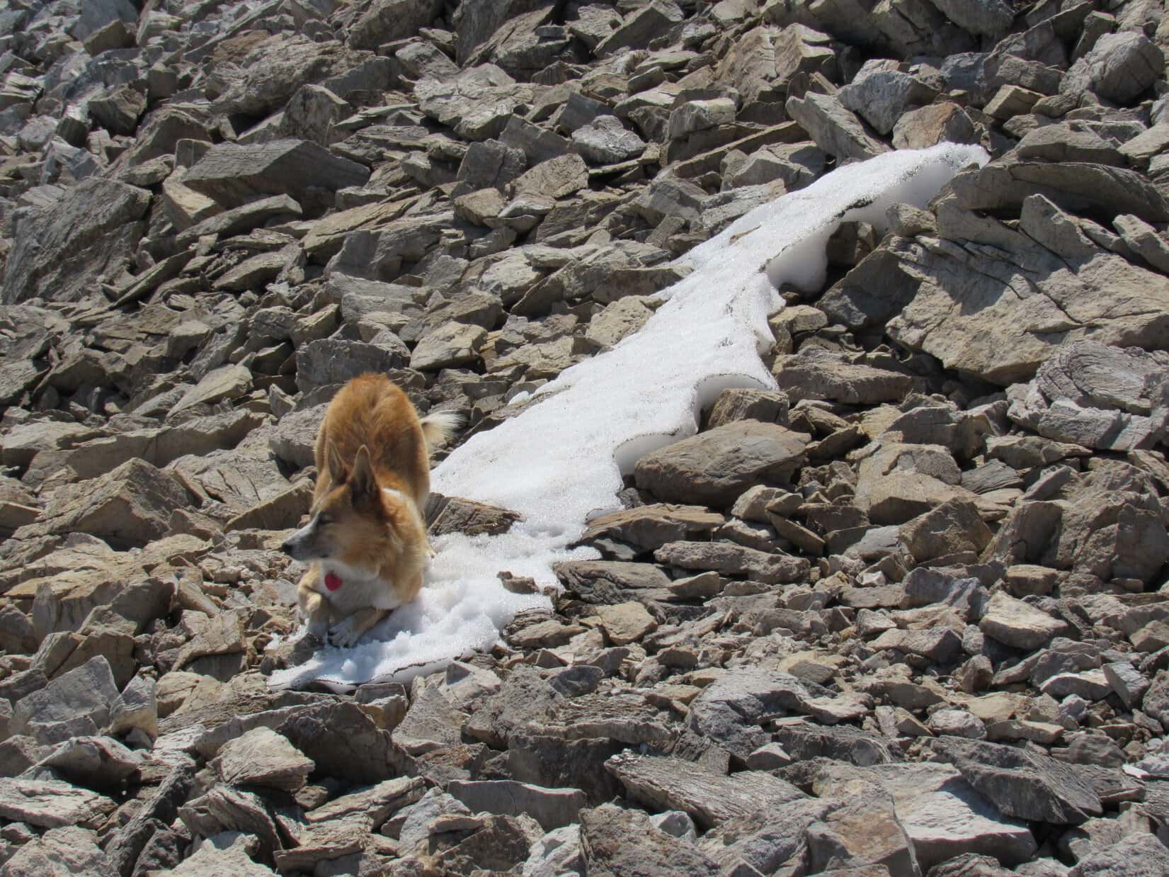
At first, all was well. The stroll along the ridgeline was easy. Lupe made great progress. She even found a delightful patch of snow.
Loop enjoying a little patch of snow she found.
The easy trek was soon over. Even at some of the lesser high points along the way, the terrain became too rough to stay right up on the ridge. Lupe had to down climb a bit to get around them, negotiating a way through collections of large boulders. Slow going, but at least possible. Loop always stayed toward the less steep NW (R) side of the ridge.
The incredible scene to the S of dark mountaintops jutting up from an ocean of white reminded SPHP of photos in airline magazines. Lupe has never been in an airplane. She probably never will be. This might be as close to having that airliner kind of view as Lupe would ever get.
Before Lupe even got to High Point 7320 (2,231 m) something happened that they never show in airline magazines. All of a sudden, that bright white ocean of clouds flooded up in a swelling tide, completely swallowing Mount Saint George in a matter of seconds. Lupe was engulfed in fog again.
Nope! Loopster wasn’t turning back. Foggy or not, the American Dingo had come too far, and the summit of Mount Saint George was too close. One way or another, she was going to find out if she could get to the top or not. Sadly, there wouldn’t be any views now, even if she made it. No matter. Reaching the summit in fog would still count as a legitimate peakbagging success.
Maybe it was smart to hurry things along, though. SPHP didn’t like the notion of being way up here in fog for hours on end. This time it didn’t seem likely the clouds would dissipate. Onward!
Lupe reached High Point 7320 (2,231 m), but didn’t bother going all the way to the top. She passed only 20 or 30 feet below it, again staying to the R. Beyond High Point 7320 was a relatively flat area of small brown stones leading to the next somewhat lower high point nearby. Beyond that next high point, Lupe was seldom right on the ridgeline. She stayed NW (R), skirting past one high spot after another.
It was slow going, scrambling among large rocks and boulders on steep slopes the entire time. Such limited visibility made things more difficult. Lupe came to drop offs that couldn’t be seen soon enough to avoid having to retrace some hard won gains to down climb and go around them. After each down climb, Lupe tried to regain her lost elevation.
Coming to drop offs in the fog usually meant retracing some progress and down climbing to get around them before returning to the ridge a bit farther on.Lupe up on the ridgeline sometime after getting by High Point 7320 (2,231 m). Photo looks ENE.
The fog also made it impossible to see how much progress Lupe was making. She had gone what seemed like a considerable distance beyond High Point 7320, when suddenly the fog thinned. For a brief moment it was possible to see farther along the ridge. Dark rocks. Higher ground ahead! Lupe was getting close to the summit! It wasn’t that far away! The fog closed in. The view vanished.
There was a problem. Lupe was on a platform of light gray rock. 15 feet ahead the platform ended abruptly at a drop of unseen proportions. The platform narrowed toward the end. It was like walking a plank. SPHP peered over both sides of the plank. To the L was a cliff. To the R talus fields of darker rock could be seen well below where Lupe was. They were steep, steeper than anything that had come before.
Lupe reaches the plank leading to a sudden drop off. Photo looks WSW.
This would be the biggest down climb yet. Loopster would have to retrace more of her route to even start it. She would then be on that very steep talus slope. Yet if Lupe could get past this point, maybe she could quickly reach the summit?
The view ahead had only appeared momentarily. Maybe what SPHP had seen wasn’t really the summit, just another of multiple high points on the way? Maybe she couldn’t even get to the top of what had been so briefly glimpsed?
Standing there wondering in the enduring fog on the plank, the situation was starting to feel intimidating. Unnerving. Lupe seemed fine. So close, yet …
A low rumble, muffled and distant. Thunder? Oh, brother. Not up here!
It was the straw that broke the camel’s back. If a storm was coming this was no place to be. Close or not, whether Lupe could have made it or not, it was time to get out of here. Enough playing with fire. Time was up. Lupe and SPHP turned back. Within moments, thunder again, more distinctly twice in quick succession. Closer, but still a way off. It was coming from the W or SW. Hurry, hurry!
On the retreat, Lupe passed so close to the top of High Point 7320 (2,231 m), that SPHP had her scramble briefly to its summit. This was it! As high as Lupe was ever going to get on Mount Saint George. A couple of photos, then time to flee. No views in the fog, anyway.
Near the top of High Point 7320 (2,231 m). Photo looks SE.Lupe at the top of High Point 7320 (2,231 m). This is as high as Lupe ever made it on Mount Saint George. It was a valiant effort, but she’s still 82 feet below the elevation of the true summit. Photo looks S.
On the way back to the N end of the summit ridge, thunder was heard with increasing frequency. Still distant, but louder and louder. The storm was moving this way.
Lupe and SPHP had only barely started down the NE ridge when Lupe became frightened. The thunder was getting unnervingly loud. The Carolina Dog begged SPHP to stop and hide. Not possible. No place to hide existed. Way too high and exposed on the mountain, down as fast as possible was the only answer. SPHP urged Lupe onward.
No lightning was seen, but the thunder continued at regular intervals. SPHP tried to reassure Loopster as she worried over each fresh rumble. After a particularly loud roar, SPHP reached down to pet Lupe and got shocked twice. The Carolina Dog’s fur crackled with static electricity. Now Lupe wasn’t the only one truly alarmed.
A shock happened once more, but not as strongly the second time. Down, down, down forever. It started to rain. Out came the rain poncho. Poor Loop got soaked. The thunder finally faded. The storm had moved off in another direction. Two thirds of the way down the endless NE ridge, the fog lifted. For a while it continued raining, but only lightly now.
The waterfall down at the gash had tripled in flow! For a few minutes the sun came out, shining briefly on the Carolina Dog now busy sniffing and exploring like on any other day, the fearsome thunder only a memory. By the time Lupe was back on the microwave tower road, the fog had returned.
Safe and sound back on the microwave tower road. Photo looks E.Remember! This was all your idea, SPHP! …. No worries Loop! I think you did fabulous, all things considered!Miss Curly Tail happy to be checking the forest for squirrels again.
What a crazy day! Memorable for sure. So close, but denied!
Could Lupe have gotten to the summit of Mount Saint George(7,402 ft.) under more favorable conditions, or had she been destined to failure no matter what from the very start on a mountain that was simply an impossible challenge?
We’ll never know. Puppy ho! Onward! (7:20 PM)
Looper on High Point 7320, as high as she ever made it on Mount Saint George, 8-5-17