Day 10 of Lupe’s Summer of 2016 Dingo Vacation to the Canadian Rockies, Yukon & Alaska
The sky was overcast, but it wasn’t raining. What time was it? Good grief! Almost 9:30 AM already! SPHP came to. Lupe was looking way perkier than SPHP. Her successful climb up King’s Throne yesterday only seemed to have enlivened her. SPHP on the other hand … well, it didn’t matter, today needed to be a rest day, anyway.
Lupe and SPHP got water and pitched garbage at the campground. SPHP straightened up the G6. There were a few squirrels around, so Lupe was happy. When all was back in order again, Lupe and SPHP drove down to see Kathleen Lake. A crew was taking down big tents that had been set up for some youth group over the weekend. The tents had been flapping noisily in the wind much of the night.
King’s Throne Peak(6,529 ft.) was across the bay. SPHP had been hoping for a clear, bright shot of Lupe at shining blue Kathleen Lake with mighty King’s Throne illuminated by morning sun in the background, but it wasn’t going to happen. The top of the mountain was scraping clouds. There wasn’t a ray of sunshine anywhere. Kathleen Lake looked green, instead of the brilliant blue it had appeared only yesterday.
Lupe at Kathleen Lake with King’s Throne Peak in the background. Lupe had been to the summit yesterday! Photo looks SW.
There wasn’t a real plan for the day. Lupe and SPHP drove to Haines Junction. SPHP managed to get a shower at a motel. Much better! The skies were clearing. Maybe it was time to head N and see what Lupe’s options were? On the way N, Lupe went by Mount Decoeli(7,650 ft.).
Mount Decoeli (R) from the Alaska Highway NW of Haines Junction. Photo looks WNW.
SPHP had hopes that Lupe would be able to climb Decoeli, but not today. It was too much for today, right after King’s Throne. Maybe it wasn’t a bad idea to check out the trailhead, though? SPHP found the trailhead on a hill more than 10 miles N of Haines Junction. The trailhead was really just a big paved pullout on the W side of the Alaska Highway. There was no sign, no information, nothing except free parking.
Mount Decoeli from the Alaska Highway, not far from the long paved pullout that serves as a trailhead. Photo looks W.
It seemed like a good idea to stop by the Tachal Dhal visitor center for information. SPHP knew the visitor center was located near the S end of Kluane Lake, a huge lake E of the Saint Elias range. Lupe and SPHP continued N on the Alaska Highway. Soon the lake could be seen ahead, flanked by mountains to the W.
Lupe near the Alaska Highway. Kluane Lake is in view! Photo looks NNW.
Kluane Lake was huge and gorgeous! Before even going to the visitor center, Lupe and SPHP stopped at a large pullout along the shore at the S end of the lake.
Lupe in Kluane Lake. She reported that the water was clear, cold, and good to drink. The weather, breezy and bright. Photo looks N.
Kluane Lake made a huge impression. To the N, the cold, blue waters stretched to the horizon like a Yukon sea. E of the lake, desolate unknown peaks marched N toward the Arctic until they vanished from view. NW across the lake was scenic Sheep Mountain(6,400 ft.), a peak SPHP hoped Lupe might be able to climb. To the W was the wide, flat Slims River valley. Strange clouds of dust blew from the valley toward Kluane Lake.
Blowing dust was unexpected and puzzling. Was the Alaska Highway gravel over there? SPHP figured the dust must be coming from traffic on the Alaska Highway or road construction. Later, it became evident the dust was being blown up by winds sweeping over dried out mud flats along the Slims River.
Clouds of dust were rising up from the Slims River valley, close to where the Tachal Dhal visitor center is located. At first, SPHP thought traffic or road construction was the cause. It turned out to be dust blown from dried out mud flats along the Slims River. Photo looks W.
After Lupe had a chance to wade in Kluane Lake and have a refreshing drink of Yukon water, Lupe and SPHP went on to the Tachal Dahl visitor center. The visitor center was located in a small building in the Slims River Valley W of both Kluane Lake and the Alaska Highway. SPHP went in to inquire about trails in the area.
There was bad news for Lupe about the trail to Sheep Mountain. It was temporarily closed due to recent grizzly bear activity. SPHP chatted with a ranger about a much longer trail up the Slims River Valley to the Kaskawulsh Glacier. The best glacier viewpoint was from Observation Mountain(6,824 ft.), but getting there would involve a 3 day/2 night backpacking trip and major stream fords.
As a nice day hike, the ranger suggested the Bullion Plateau trail. The Bullion Plateau sounded interesting, but it was already afternoon and the trail was too long to consider today. How about something short and easy? Right away, the ranger suggested Shepherd’s Knoll, a hill not too far away up the Slims River valley. A very short trail goes to the top of Shepherd’s Knoll where there are views both up the valley and back toward Kluane Lake. It sounded perfect!
A little N on the Alaska Highway from the turn to the Tachal Dhal visitor center, another gravel road leaves the highway. This road goes 2.6 km up the Slims River valley to the Tachal Dahl trailhead. Lupe left for Shepherd’s Knoll from here. Lupe and SPHP started out on the main trail, which ultimately goes to the Kaskawulsh Glacier. The trail began as an old roadbed going through a forest.
It didn’t take Lupe long, maybe 15 minutes, to reach an intersection with the Sheep Creek trail. A few hundred feet farther along, on the valley side of the main trail, Lupe found the side trail to Shepherd’s Knoll.
Lupe near the start of the Shepherd’s Knoll trail. Photo looks SE.
The Shepherd’s Knoll trail wasn’t long at all. It climbed partway up a small hill and vanished. Lupe continued on higher up the hill, checking out the views from different vantage points along her way.
Lupe climbing Shepherd’s Knoll. The trail soon vanished, but Lupe continued up, checking out the views from various vantage points along the way. Photo looks NE.
For as little effort as it took for Lupe to get here, the views from Shepherd’s Knoll were impressive.
Looking SW up the Slims River valley.Dust blows down the Slims River valley toward Kluane Lake. Photo looks E.Looking S across the Slims River valley from Shepherd’s Knoll.A closer look at the snow-capped mountain across the valley using the telephoto lens.The beautiful Slims River valley. Photo looks SSW.SPHP believes the high hill in the distance is part of the Bullion Plateau. Photo looks WNW.The Bullion Plateau? It seemed to be in the right direction. Photo looks WNW.A wider view of the Bullion Plateau vicinity.
Even though getting to Shepherd’s Knoll hadn’t taken Lupe very far up the Slims River valley, it was certainly a worthwhile easy trek. Lupe would have liked to do much more exploring in the Slims River area, but this was a rest day, and it was starting to get late. Lupe and SPHP returned to the Tachal Dahl trailhead.
No one had been at the trailhead before, but now there were nearly a dozen people here. They had just returned from an overnight backpacking trip to the Kaskawulsh Glacier. A campground near the glacier was about as far as most of them had made it. Only one person had succeeded in reaching the top of Observation Mountain. The trip was more strenuous than they’d anticipated.
Lupe and SPHP went back to Kluane Lake, but this time a bit farther N along the W side of the lake. A forested hill projected partway into the lake from mud flats deposited by the Slims River. Silt is gradually filling in this end of the lake.
Over time, silt and mud deposited by the Slims River will completely surround the forested hill seen here by filling in adjacent portions of Kluane Lake. Photo looks ESE.
Evening was coming. The views from the pullout along the S shore of Kluane Lake earlier in the day had been so beautiful that Lupe and SPHP returned to enjoy the evening there.
Lupe spent a few happy hours exploring the shore of Kluane Lake, while SPHP watched the ancient dust blow, and the waves roll in.
Sheep Mountain from mud flats at the far SW end of Kluane Lake. Photo looks NNW.Lupe along the S shore of Kluane Lake the evening of 8-8-16. Photo looks W.Happy times at Kluane Lake in the Yukon. Photo looks E.Evening at Kluane Lake, Kluane National Park, Yukon Territory, Canada 8-8-16.
Well, Loopster, it’s all been kind of leading up to this lately. Don’t know if you are going to meet with any success today or not, but we’re at least going to try it.
Lupe wasn’t worried. She wasn’t paying any attention to SPHP at all. The eastern sky was just beginning to get light, but she could see cows, lots of big, beautiful, black cows, in the pastures along I90. The cow-crazed American Dingo was busy barking for all she was worth. A little later on, NW of Sundance along Hwys 14 & 24, there were herds of deer to entertain her, too.
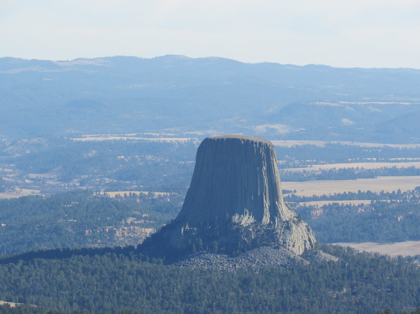
Wyoming Hwy 24 goes right past America’s very first national monument. Lupe’s first stop of the day was a quick one to see Devil’s Tower(5,112 ft.). Not a soul was around early on a Sunday morning in November. The sun’s first rays struck the tower while Lupe was there to see it.
Lupe arrives at Devil’s Tower, America’s first national monument, in time to see the first rays of the morning sun on it. Photo looks W.Devils Tower plaque along Hwy 24.Devil’s Tower in the early morning light. Photo looks W.
Lupe and SPHP didn’t go into the national monument. Devil’s Tower is one peak Lupe is never going to bag unless she sprouts Dingo Wings. However, with a little luck, she was going to get to see the top of it today! After a good look at Devil’s Tower, Lupe and SPHP continued N on Hwy 24.
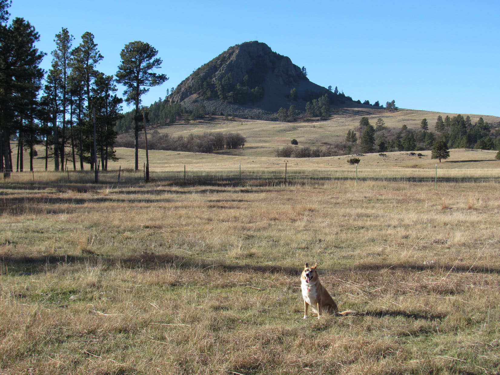
On 3 consecutive Black Hills Expeditions to the Bear Lodge Mountains, Lupe had seen distant views of both Devil’s Tower and the Missouri Buttes from a variety of vantage points. They are the most famous and dramatic landmarks in the entire NE Wyoming region. Although climbing Devil’s Tower was completely out of the question for the Carolina Dog, she was here now to try her luck climbing the Missouri Buttes(5,374 ft.).
SPHP had good reasons to believe Lupe might not make it. There are actually 4 separate buttes in the Missouri Buttes cluster. All are located within an area covering no more than 2 square miles about 4 miles NW of Devil’s Tower. The problem was, all of the Missouri Buttes are on private land. Lupe’s first hurdle was to find and secure permission from the landowner to enter the owner’s private property.
Even if permission could be secured to access the private property, there was another big problem. The only information SPHP found online about climbing Missouri Buttes was a trip report by PanamaRed on SummitPost.org indicating there was Class 3 & 4 scrambling with some exposure near the top of the highest NW Missouri Butte. Lupe and SPHP are up for some light Class 3, but anything approaching Class 4 just wasn’t going to happen.
Three miles N of Devil’s Tower junction, Lupe and SPHP left Highway 24 on Barlow Canyon Road. The gravel road crossed the Belle Fourche River, went a mile N, and then turned W.
Looking S at Devil’s Tower from Barlow Canyon Road. Lupe loved this view. Not for the big rock in the distance. All those beautiful black cows were what caught her fancy!
SPHP wasn’t certain where to go, but wound up at the Lake Guest Ranch headquarters located near the NW end of Missouri Buttes Lake. Even though it was early on a Sunday morning, SPHP received a friendly reception from a couple of ranch hands. The ranch owner was available to talk to!
Lupe on her way to seek permission to climb the Missouri Buttes.
SPHP was invited in to talk to the owner. The Lake Guest Ranch HQ was a pretty cool place inside. SPHP was hopeful. When SPHP explained to the owner why Lupe was here – to seek permission to climb the Missouri Buttes, the response was polite, but firm. The answer was no. The owner’s insurance wouldn’t allow it, it was hunting season and dangerous, etc.
The negative response was devastating! Well, not devastating – there are plenty of mountains in the world Lupe can climb – but it was disappointing. That was that, though, nothing could be done about it. Lupe wasn’t going to get to climb the Missouri Buttes. Until …
Until the Lake Guest Ranch owner said that he didn’t even own the land the 2 highest Missouri Buttes are on. Didn’t own the land?! Who did? It was part of the Nuckoll ranch. His neighbor J.W. Nuckoll owns the land came the response. SPHP was given a phone number for the Nuckoll ranch.
Back in the G6, SPHP tried the phone number. A recording, but no response. Hmmm. Didn’t we pass a sign or something for the Nuckoll ranch on the way here, Loop? I think we did.
Not sure, SPHP. Unless it was branded on the side of a cow, I wouldn’t have noticed!
Lupe and SPHP drove off from the Lake Guest Ranch looking for the Nuckoll ranch. Along Barlow Canyon Road, there it was. A mailbox said Nuckoll, and an old building nearby said something about Nuckoll sheep and wool. This was it! A driveway led more than a mile S into a side canyon before ending at two houses. A sign on the first one said J.W. & Thea Nuckoll.
J.W. was an old-timer. He was on oxygen, but was friendly when SPHP met him. SPHP explained why Lupe was here. J.W. said he had climbed the Missouri Buttes himself. He had even climbed Devil’s Tower! That was good, that was very good. Surely he would understand?
He did! Mr. Nuckoll agreed to let Lupe and SPHP climb the Missouri Buttes. He had even more good news. When SPHP asked how difficult a climb it was, Mr. Nuckoll told SPHP about a trail to the top of the highest NW Missouri Butte. That sounded great! SPHP then asked about the NE Missouri Butte, too. Mr. Nuckoll said it was even possible to ride a horse to the top of the NE butte. Lupe would have no problem! SPHP thanked Mr. Nuckoll, and went off to tell Lupe the good news.
In just a few minutes, Lupe was on her way (8:51 AM, 53°F)! The first part of the hike started farther along the driveway, beyond the two houses. For a short distance, Lupe was on a road continuing up the little canyon. There were lots of cows around. Lupe and SPHP climbed a forested slope heading SSW to avoid them. Up above, Lupe arrived at the edge of a huge gently sloping field. The highest NW Missouri Butte(5,374 ft.) was already in view!
Lupe arrives up at the huge, gently sloping field. The highest NW Missouri Butte was already in view. Photo looks SW.
The somewhat lower NEMissouri Butte(5,212 ft.) is closer to Devil’s Tower, and wasn’t any farther away than the highest NW Butte. Lupe and SPHP decided to go for the NE Missouri Butte first. Even though the SE end of the butte looked the most rugged, Lupe went over to take a look at it, and see if Devil’s Tower was in view.
Lupe approaching the NE Missouri Butte. Photo looks S.Devil’s Tower was already in view even before Lupe started her climb up the NE Missouri Butte. Photo looks SE.Looking NE before climbing the NE Missouri Butte.The SE end of the NE Missouri Butte as seen from the N. The highest part of the NE Missouri Butte is close to this end, but the butte is much more easily climbed from the NW.
The SE end of the NE Missouri Butte was quite steep and rocky, but it didn’t look impossible to climb up from here. However, Lupe had already seen that the NW end of the butte was definitely easier. Lupe and SPHP went back around to the NW end, where Lupe made her ascent.
Slippery pine needles on a moderately steep slope were about all Lupe had to contend with going up. Before long, Lupe was at the true summit of the NE Missouri Butte, which proved to be near the SE end of the ridge. An old wooden cross was sticking up from a summit cairn near some of the highest rocks. The panoramic views toward the E were spectacular!
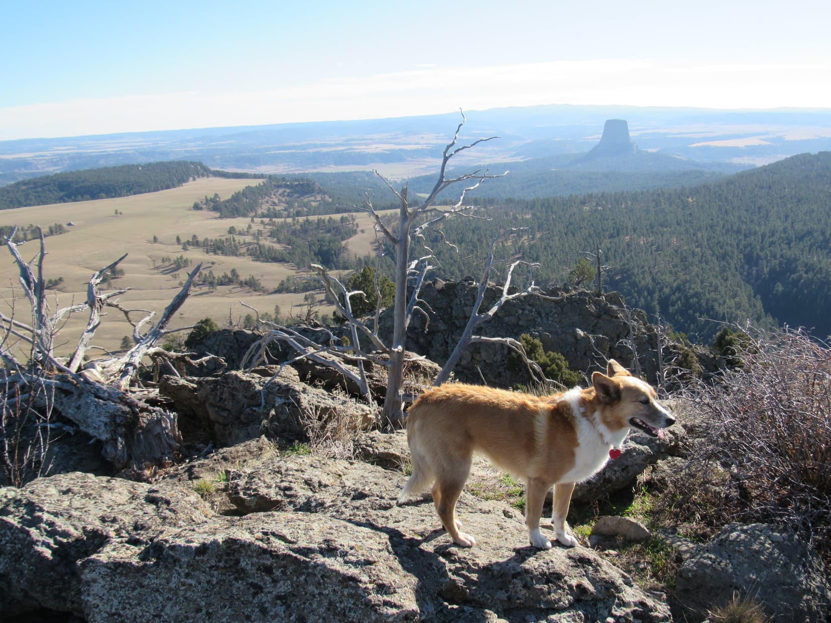
Of course, Devil’s Tower was the most striking landmark in view. Much farther away, Warren Peaks(6,650 ft.) and Inyan Kara(6,360 ft.) could be seen, too, although they didn’t show up all that well in the morning haze. Long pine-covered ridges with yellow cliffs, and the Belle Fourche River valley were off to the NE. To the W, Lupe could see her next peakbagging goal, the NW butte, which is highest of all the Missouri Buttes.
Lupe at the summit of the NE Missouri Butte. Photo looks SE.The highest NW Missouri Butte as seen from the 2nd highest NE Missouri Butte. Photo looks WNW.Looking ESE from the summit.The highest NW Missouri Butte again. A small part of Missouri Buttes Lake is in view along with the HQ of the Lake Guest Ranch. Photo looks W.The Lake Guest Ranch HQ using the telephoto lens. Photo looks WSW.Long pine-covered ridges with yellow cliffs dominated the views to the NE.
Lupe and SPHP took a break up on NE Missouri Butte. The views were really awesome. It was so wonderful that Mr. Nuckoll had granted Lupe permission to come and see this unique scene. Lupe could see the top of Devil’s Tower from here!
What a sight! Lupe could see the top of Devil’s Tower from NE Missouri Butte. She didn’t even have to climb the tower or take a helicopter up to see it. Photo looks SE.Looking SSW at a couple of the lower Missouri Buttes.
After 45 minutes spent enjoying the summit of the NE Missouri Butte, it was time for Lupe to go see if she could find the trail Mr. Nuckoll spoke of leading to the top of the highest NW Missouri Butte. Lupe went down the W slope of the NE Missouri Butte, and crossed the saddle over to the NW butte.
A big gash was visible on the NE side of the NW Missouri Butte, but it looked mighty steep and straight. Mr. Nuckoll had spoken of the trail up the butte making a sharp turn. SPHP didn’t think Lupe should try going up that NE gash. It didn’t look like there was any way a trail could make a sharp turn from there.
The post by PanamaRed on SummitPost.org didn’t say what route he had taken to the top, but SPHP had the impression from photos PanamaRed posted that he had climbed up from the NW. If that led to Class 3 & 4 scrambling, Lupe wouldn’t succeed in going up that way either.
Lupe started up the NW Missouri Butte from a boulder field at the base of the N face.
Lupe starts up the highest NW Missouri Butte. She went up the boulder field and then climbed through the trees to the base of the cliff. She then worked along the base of the cliff to the W (R). Photo looks SSW.
Lupe climbed up beyond the boulders into a zone of trees and bushes. It was steep going, but still doable. The worst part was the incredible number of low thorny bushes. They didn’t seem to bother Lupe, but SPHP had to watch carefully before grabbing on to anything.
When Lupe reached the base of the cliff, she worked her way to the W, still climbing steeply all the way among trees and thorny bushes. Her route led toward a couple of large rock protrusions sticking out to the N. About the time she got close to the first big rock formation, Lupe reached some steep grassy ground above most of the trees and thorny bushes.
It looked like there was a route continuing W (R) up a channel between rock formations. How high up this route went was difficult to see, although it looked like it might be possible to make a sharp turn to the E (L) near the top. Maybe that was the way to go? While pondering, SPHP suddenly realized Lupe was already on a very faint trail. The barely discernable trail went steeply up a ramp toward the E (L) from here.
Maybe it was best to check out the ramp first? The ramp went up to a high point where sunlight could be seen. May as well see what was on the other side of that high point, before attempting to negotiate the rocky channel.
The ramp was a relatively easy climb. In just a few minutes, Lupe and SPHP were at the top.
Lupe sits on a rock just above the top of the ramp. Photo looks W, back in the direction she came up the ramp. The ramp itself is not shown.This view greeted Lupe at the top of the ramp on the N face of NW Missouri Butte. The NE Missouri Butte, where she had just been, is seen on the L. It turned out that the ramp did not end here. It made a sharp turn to the S (R) in front of the little tree that looks like it is growing out toward Devil’s Tower. The ramp then leveled out, becoming an easy walk as it went S along the upper NE face of the butte. Photo looks SE.
Devil’s Tower and the NE Missouri Butte, where Lupe had just been, were both in view from the top of the ramp. Peering S around the corner to the NE side of the butte, SPHP was surprised and pleased to see that the ramp continued. It leveled out quite a bit as it traversed the NE face of the butte.
The ramp’s continuation was an easy walk, but didn’t go very far. It soon ended at place where a few rocky steps up brought Lupe onto the moderately sloping NE part of the summit area. The good news was that Lupe was almost to the top! A short walk through a forest of junipers would take her to the summit of the highest NW Missouri Butte. Her peakbagging success was assured!
The bad news was that Lupe’s nemesis was here, too, in great profusion! The first thing SPHP saw upon gaining the summit area was cactus. Lots of big cacti clusters were scattered around. Lupe would have to be carried the rest of the way to the true summit.
Cacti like these grew in large patches scattered around the summit area. Lupe had to be carried the last 150 feet to the true summit of the NW Missouri Butte.
So, Lupe wound up being toted the last 150 feet to the true summit of the highest NW Missouri Butte. She took her summit break there, under strict orders not to move around. She wanted to be where SPHP was anyway, so it all worked out fine.
Lupe reaches the summit of the NW Missouri Butte, the highest of them all! Photo looks NNE.There was an old radio tower on top of the NW Missouri Butte. The shack was unlocked and open. It was full of dirty, apparently unusable, old electronic equipment. Much of the summit area on NW Missouri Butte is covered with juniper trees like those seen here, although the area of the true summit where Lupe is, was largely free of them.
PanamaRed had posted a photo of the Missouri Buttes USGS survey benchmark, but at first SPHP didn’t see it. A brief search revealed it partially hidden by a bush along the very NW edge of the summit, a little way W of the highest rocks.
This Missouri Buttes USGS survey benchmark was partially hidden by a bush along the very NW edge of the summit area. It was not right at the highest rocks.The Missouri Buttes USGS survey benchmark is seen at (Center) near the bottom of this photo. Photo looks W.
The best views from the NW Missouri Butte in the vicinity of the true summit were the panoramic views to the W and N. Junipers blocked the views in other directions. Even though the air was rather hazy, it was still possible to see the outline of the Bighorn Mountains to the W. Off to the NW and N, there was nothing higher than NW Missouri Butte anywhere in sight.
Lupe near the true summit. Photo looks W. The Bighorn Mountains could be seen on the horizon, but don’t show up in the photo. Lupe assures you, they are out there!Looking down at land immediately to the W of NW Missouri Butte. Missouri Butte Road leads right to the NW Missouri Butte, but may not be entirely on the Nuckoll ranch. Access to it was from the road leading to the Lake Guest Ranch. Lupe didn’t start her trek from down there anyway, although it would have been a much closer starting point.Thanks to Mr. Nuckolls kindly granting permission to be on his land, Lupe got to visit the top of this highest Missouri Butte. Photo looks NE.Lupe at the true summit. There were cliffs just beyond the rocks. Photo looks N.Cliffs along the N edge. Photo looks NE.
After 25 or 30 minutes relaxing near the true summit, it was time to explore the SW part of the summit area, which was hidden by juniper trees. SPHP had to carry Lupe for fear of the cacti, but she didn’t mind getting a free ride. From the SW end of the summit area, it was possible to see the Lake Guest Ranch HQ and Missouri Butte Lake.
Missouri Buttes Lake and the Lake Guest Ranch HQ (seen to the R of the lake). Photo looks SW.
Lupe also had a clear view of the 2 lower S Missouri Buttes.
The 2 lower S Missouri Buttes as seen from the SW end of the NW Missouri Butte summit. Photo looks S.
Lupe and SPHP returned to the summit for a final look around. Lupe then got carried back down to the NE end of the summit area near the start of the ramp. Before taking the ramp down, Lupe checked out the views from this end of NW Missouri Butte.
Lupe at the NE end of the NW Missouri Butte summit. She had a fabulous view of the NE Missouri Butte (L) and Devil’s Tower (R) from here. Photo looks ESE.Looking SE.Devil’s Tower from NW Missouri Butte. Photo looks SE.Looking E at NE Missouri Butte.
Lupe took the ramp all the way back down to its beginning on the steep grassy slope near the large rock protrusions where SPHP first noticed the very faint trail. Now that it was clear there actually was a trail, it was possible to see it continuing on down the mountain.
The trail went down to a much larger boulder field than the one Lupe had crossed coming up. This area was well to the W of the area of trees and thorny bushes below the cliff Lupe had been in earlier. Lupe went all the way down the boulder field, passed through a couple of stands of trees, and reached the pasture below the N face of NW Missouri Butte.
From near a stock pond, it was possible to get a good look at the best route up the mountain.
View along the cliffs near the top of the N face of NW Missouri Butte. Note the orange coloration on some of the rocks. (Probably orange lichens.) Photo looks W as Lupe was about to go down the steep part of the ramp (not pictured).Lupe makes it down off the butte. NE Missouri Butte is in view beyond the stock pond. Photo looks E.The easiest route up the NW Missouri Butte is visible in this photo taken from near the stock pond. Photo looks S at the N face of the butte. The easiest route up is through the trees on the W (R) to the loose rocks. Climb the loose rocks up to the trees below the orange spot near the center of the top of the butte. From there, the ramp leads to the E (L) up along the trees and bushes seen to the L of the orange spot. The ramp then curls around the E (L) side of the mountain (out of view) to gain the NE slope of the summit area. Easy, squeezy! Class 2 or Class 3 Lite all the way!Lupe and SPHP originally came up through the trees and thorny bushes from the lower L. Not the best way to do it! Come up from the R, get through the trees to the steep grassy area below the orange spot, then go L up the ramp. The trail should become visible while still among the loose rocks before reaching the trees below the orange spot. Photo looks N.
Lupe had climbed both the highest Missouri Buttes. Her Expedition No. 181 was an unqualified peakbagging success! However, there was still a lot of daylight left. Why not go take another look from the top of the NE Missouri Butte? A few hours had gone by, and the sun would be shining from another angle. There was only a little bit of cactus up there that SPHP had seen at the far SE end. Lupe could avoid it easily.
Lupe was fine with going back up. So once again, she climbed the W slope and then followed the summit ridge SE to the top of the NE Missouri Butte. With the afternoon sun now lighting up the near side of Devil’s Tower, the view was even better than earlier in the day.
Devil’s Tower in the afternoon sun from NE Missouri Butte. Photo looks SE using the telephoto lens.Inyan Kara Mountain is seen faintly on the far R horizon.Hmmm. That Carolina Dog looks a bit familiar! So does that odd tree stump-shaped rock in the distance.
Lupe and SPHP spent another 30 beautiful minutes up on the NE Missouri Butte. Then it was time to call it a day. SPHP had told Mr. Nuckoll that it would be great to get a chance to talk to him some more when Lupe returned from Missouri Buttes. It was probably best to get there well before the Nuckolls wanted to have their supper.
Lupe left NE Missouri Butte for the 2nd and final time. She liked crossing the huge, wide open pasture, and going through the forest on the way back. Before long, she was back at the Nuckoll’s house (3:26 PM, 55°F).
Looking S at one of the lower Missouri Buttes on the way down the NE Missouri Butte.NW Missouri Butte on the way back. Photo looks W.
No one was around. SPHP checked both homes, but there was no one to thank for the wonderful day Lupe had on the Missouri Buttes. No telling where the Nuckolls had gone, or when they might return. SPHP left a note in the door.
Then a very lucky American Dingo, one which had been to the top of the two highest Missouri Buttes, enjoyed a noisy evening drive past herds of cattle and deer on her way home.Links: