Start – 8:55 AM, 50 °F, Pilot Knob trailhead of Centennial Trail No. 89
The first half of October had been cold and wet, but that was history now. This morning was clear and bright, and it was already 50 °F when Lupe and SPHP arrived at the Pilot Knob trailhead along USFS Road No. 208 (Merritt Road). The air was calm down here at the trailhead, but Lupe could hear a breeze up in the pines.
Lupe arrives at the Pilot Knob trailhead of Centennial Trail No. 89. It was going to be a great day with highs near 60°F expected. Photo looks NNE.
Lupe was eager to get started, which was a good thing. Days are getting short by the second half of October, and she had a long way to go. The South Boxelder Creek trailhead of Centennial Trail No. 89 near Nemo was 7.6 miles away, a 15.2 mile round trip. And that was if Loop stayed on the trail, which she wouldn’t, because a little off-trail peakbagging was part of the plan for the day, too.
It’s 7.6 miles one way to the South Boxelder Creek trailhead from the Pilot Knob trailhead – 15.2 miles round trip. And that’s if you don’t climb any mountains on the side along the way!
Only a few minutes on the trail got Loopster up the first forested slope and around the bend to the N where she could see Pilot Knob(5,440 ft.) beyond a big field. Pilot Knob didn’t look like much from here, but Loop had been there recently on Expedition No. 235. Pilot Knob was actually a fun little climb and the views from the top had been surprisingly good.
Hey, SPHP! There’s Pilot Knob (L) again! We were just up there not too long ago, remember? Photo looks WNW.
Lupe followed Centennial Trail No. 89 NNW along the E side of the big field. Near the end of the field, the trail curved NE and went past a sign for Boodleman Spring, which didn’t seem to have much in the way of water. The trail got steeper after passing Boodleman Spring, and soon turned N again going up a forested valley.
After passing under a big power line, Centennial Trail No. 89 bent NW paralleling the power line. When the power line reached a high point, the trail curved away to the E. Lupe briefly left the trail to check out this high point, but there really wasn’t much to see.
Returning to the trail, Loop and SPHP followed it around the S end of a nearby hill to the E.
Going around the S end of the hill E of the power line’s high point. Photo looks E.
Lupe had been gaining elevation ever since leaving the Pilot Knob trailhead. However, as Centennial Trail No. 89 curved back around to the N on the E side the hill, the trail reached a high point, too.
Ahead was a limited view of a high ridge beyond a deep valley. Several high points could be seen along this ridge, which extended off toward the NNW. The topo map revealed that the closest high point was Peak5701, the highest spot along the entire ridge.
Peak 5701 (Center) is in view as Centennial Trail No. 89 descends into the valley of the West Fork of Estes Creek. Photo looks NNE.
Although Peak 5701 and the rest of the ridge it was on looked intriguing, Centennial Trail No. 89 wasn’t going up there. The trail went toward Peak 5701, but upon reaching the floor of the deep valley it turned E at the base of the mountain.
The American Dingo had entered the valley of the West Fork of Estes Creek. Looper soon came to a large puddle where Estes Creek crossed Centennial Trail No. 89. The creek itself was a mere trickle only an inch or two deep.
Lupe reaches the puddle where the West Fork of Estes Creek crosses Centennial Trail No. 89. Photo looks ESE.
For 0.5 mile, Lupe continued E going down the valley on the N side of the West Fork of Estes Creek. The creek gained some flow along the way, but remained quite a small stream. NW of High Point 5452 the trail left the valley floor climbing up onto a small rise. From here, the trail turned N gaining elevation gradually as it wound around the SE end of Peak 5701.
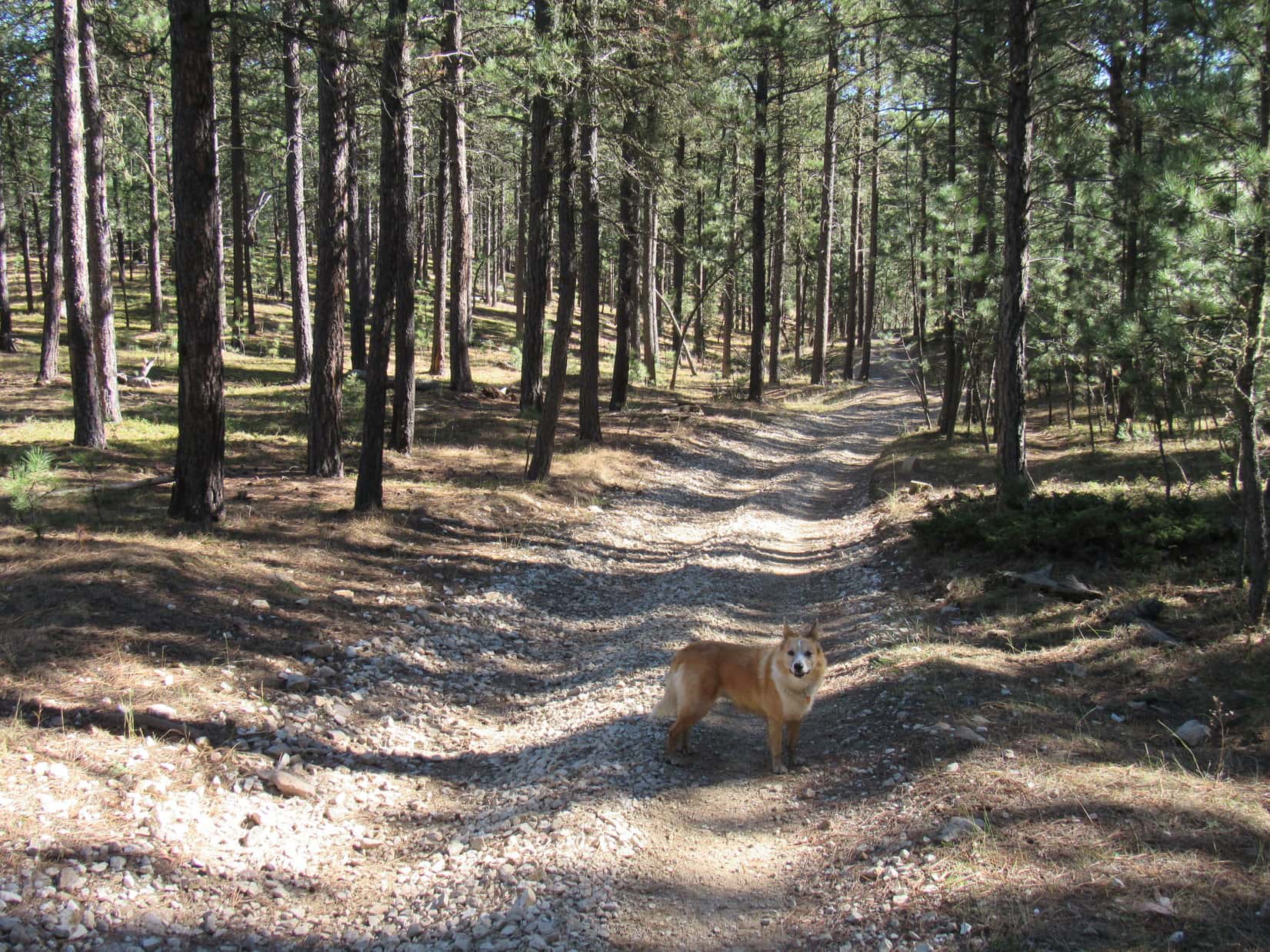
Lupe at a junction of Centennial Trail No. 89 and ATV trail No. 8251 shortly after leaving the West Fork of Estes Creek. Centennial Trail No. 89 is also an ATV trail all the way from Pilot Knob to South Boxelder Creek. In fact, it’s possible to go even farther on an ATV all the way to the Dalton Lake trailhead. Photo looks NNW.Going around Peak 5701’s E ridge. Photo looks ENE.
Centennial Trail No. 89 eventually brought Lupe around E of Peak 5701. For 0.75 mile, the trail now headed NNW roughly paralleling the long ridge between Peak5701 and Peak5628.
Now E of Peak 5701 heading NNW.
While the first part of this area was forested, farther on Lupe came to meadows, too. The Carolina Dog reached a spot where she had a fairly clear view of Peak5440 off to the NE.
Peak 5440 didn’t look too impressive. It was just a flat-topped forested hill. Yet with 360 feet of prominence, Peak 5440 was the most prominent mountain along the entire route Lupe would be traveling today. So the plan was to take a little off-trail side trip to climb Peak 5440. After seeing it, though, expectations were none too high. Loop probably wouldn’t be able to see anything but trees from up there.
Despite technically being the most prominent peak along this section of Centennial Trail No. 89, Peak 5440 didn’t look too impressive. Lupe intended to climb it anyway. Photo looks NE.
Continuing on, Looper soon had views of Peak5701 again and the long ridge going NNW from it to Peak5628. That big ridge looked a lot more intriguing than Peak 5440 did. Despite not having as much prominence, it was higher and appeared to at least offer some views. Peak 5701 even had a little snow.
Peak 5701 (L) looked more interesting than Peak 5440, and even had some snow. Photo looks SW.
The trail gradually curved toward the NE. Stands of aspens sported a few yellow leaves, the last of 2018’s autumn colors. Approaching Peak 5440, Lupe came to a couple of ponds surrounded by wooden fences.
A few colorful aspen leaves were about the last of this autumn’s display. Peak 5701 is on the R. Photo looks S.Lupe comes to a fenced-in pond as Centennial Trail No. 89 approaches Peak 5440. Photo looks NE.
Beyond the ponds, Centennial Trail No. 89 curved N again. This was as close as the trail was going to get to Peak 5440. Looper left the trail and began to climb, heading first E, then SE as she got higher up.
Lupe soon reached a grassy area on the W face of Peak 5440 that she had seen earlier from a distance. This was the only place she was likely to see much from Peak 5440. She actually had a rather nice view of Peak 5701 and the long ridge to Peak 5628 from here.
Peak 5701 (L) and Peak 5628 (R) from the upper W slope of Peak 5440. Photo looks SW.Peak 5701 from Peak 5440. SPHP sort of wished Lupe was climbing Peak 5701 instead. It looked far more interesting. Photo looks SW.
From the grassy area with a view, Lupe still faced the steepest part of the climb up Peak5440, but even so, it wasn’t difficult and didn’t take her long. The terrain soon began to level out. The topo map showed two 5,440 foot contours on the mountain. Lupe headed NE through dense forest looking for the first one, which contained by far the smallest area. A single large boulder proved to be the clear high point of this contour.
Lupe on the big boulder which appeared to be the high point of the first and smallest 5,440 contour shown on the topo map. Photo looks NW.
The area contained by the larger 5,440 foot contour was only a couple hundred yards farther NE. Loopster traveled through dense forest the entire way. She seemed to gain at least some elevation. This larger area was almost certainly higher than the big boulder, and had to be the location of the true summit.
No big boulder or other definite high point existed here, however. The true summit might have been any of a number of smallish rocks located on nearly flat terrain that sloped only very gradually toward the SE. The most interesting thing about this place was actually a 15 or 20 foot high escarpment along the NW edge of the area. Forest blocked all views, but the escarpment featured some interesting rock formations.
The true summit of Peak 5440 is right around here somewhere! Photo looks N.Hardly matters which of these rocks is the true summit of Peak 5540. Can’t see a thing except trees from any of them anyway! I’m calling this good enough for Dingo work!This escarpment along the NW edge of the summit area is cool, though! Photo looks N.
Exploring is always fun, but Peak5440 was the sort of place Lupe was only likely to get to once. Might as well linger a while to enjoy whatever the experience had to offer. It was time for a short break, anyway. The usual fare was on offer. Water and Taste of the Wild for Lupe. An apple for SPHP.
When break time was over, it was back to Centennial Trail No. 89 by the same route Lupe had taken up. Upon reaching the trail, Lupe continued N. She soon came to a sign saying it was 4.5 miles to Nemo or 3.5 miles back to Pilot Knob. Nemo was about a mile beyond the South Boxelder Creek trailhead, so this was about the halfway point.
Lupe reaches a sign near the halfway point between the Pilot Knob and South Boxelder Creek trailheads. Photo looks E.
It wasn’t much farther to another high point. Centennial Trail No. 89 had been gaining elevation, albeit quite gradually, ever since leaving the West Fork of Estes Creek. N of Peak 5440, however, the trail went over a broad, gentle pass. On the other side Lupe was soon losing elevation faster than she had gained it. She was entering the upper reaches of yet another valley.
Loop hadn’t gone far beyond the high point when she reached a sign for Caryl Spring. Caryl Spring consisted of several inches of standing water full of fallen leaves. Lupe cooled her paws off, and helped herself to a drink.
As Lupe headed toward the pass N of Peak 5440, she caught sight of this high ridge N of Peak 5628. Photo looks WSW.Loopster at the high point of Centennial Trail No. 89 N of Peak 5440. There was a major road junction here, but not much in the way of signage. Photo looks E.Starting down into the next valley. Caryl Spring is right around the bend.Lupe standing paw deep in Caryl Spring, which did have a few inches of water.
From Caryl Spring the trail continued E farther down the valley, but not for long. When the valley turned N, Centennial Trail No. 89 took off to the SE up a side draw. Lupe gained close to 100 feet of elevation going over a minor ridge extending NNE from Peak 5440. The Carolina Dog was soon over this ridge and starting a descent that would take her into Blue Draw.
Loop reached a sign indicating the South Boxelder Creek trailhead was only a mile ahead.
Gaining elevation again going over the minor ridge NNE of Peak 5440. Photo looks SE.Beginning the descent into Blue Draw after crossing the ridge. Photo looks ESE.Getting there! Only a mile to go to the South Boxelder Creek trailhead!
A junction existed where Centennial Trail No. 89 reached Blue Draw. It wasn’t clear where the road heading SW was going other than farther up the draw. Where it went didn’t really matter. Loop just needed to head down the valley. At the lower end of Blue Draw she would find the South Boxelder Creek trailhead. The trail headed NE at first, then E the rest of the way.
Lupe in Blue Draw.Approaching a seasonal stream in Blue Draw. It was just a puddle today.
The trek down Blue Draw was shady and pleasant, but it seemed like Lupe had gone more than a mile since seeing the sign about the trailhead. Finally she saw a ramp for ATV’s and a gate ahead. Just beyond the gate was the bridge over Boxelder Creek. This was it! Looper had reached the trailhead!
Oh, look! There’s the gate and ATV access ramp. We’re just about to the South Boxelder Creek trailhead!Loop on the bridge over Boxelder Creek. Photo looks NE.Boxelder Creek looking downstream (SE) from the bridge.Looking upstream (NNW) from the bridge.Lupe reaches her Centennial Trail No. 89 destination for the day, the South Boxelder Creek trailhead. Photo looks ESE in the direction of Nemo, which is out of sight about a mile away.
Despite Lupe’s side trip to Peak 5440, she had made fairly good time getting to the South Boxelder Creek trailhead. Her Centennial Trail No. 89 explorations were complete for the day, although she still had to repeat the experience going all the way back to Pilot Knob again.
Not yet, though! Time for another rest break. Lupe and SPHP relaxed for a while on a grassy bank by the creek.
So we made it! That wasn’t so hard now, was it? And look at this beautiful stream and scenic bridge to adventure!Guess that’s about it unless we come up with some other grand scheme on the way back to Pilot Knob!
Well, that would have been it, but on the way back to Pilot Knob the American Dingo made such excellent progress that when she reached the pass N of Peak 5440 again, SPHP realized that the sun wouldn’t set for at least another couple of hours.
So what do you say, SPHP? Still want to explore that big ridge going from Peak 5628 (R) to Peak 5701 (L)? Photo looks SW.
The big ridge with Peak5701 at the S end and Peak5628 at the N end was now in sight. Seemed like Lupe had enough daylight left to explore it. The American Dingo was willing, so why not?
Lupe and SPHP left Centennial Trail No. 89 heading SW for a saddle N of Peak 5628.
Lupe now off trail on her way to the saddle N of Peak 5628. Photo looks SW.
At first, the way was easy. The terrain gained elevation slowly. Lupe came to few obstacles. For a while, SPHP even thought Loop might be on a long abandoned road, but it was hard to tell for certain.
As the Carolina Dog got closer to the saddle, though, the going got tougher. No road here! Lupe passed through a very dense pine forest. Beyond that was an area of mixed pines and aspens thick with deadfall timber. Loop didn’t have much farther to go to reach the saddle, but progress in the middle of this mess was slow, slow, slow.
The map showed a road going up to the saddle. Lupe ought to come to it, but for a long way she didn’t. SPHP had about decided the road didn’t exist any more, when suddenly there was Lupe, standing right on it. Loop headed W on this road until it was clear she was due N of Peak 5628 and wasn’t going to gain any more elevation sticking with the road.
Time to start up Peak 5628! Lupe and SPHP left the road heading S up a fairly steep slope.
Lupe reaches the road leading to the saddle N of Peak 5628. Photo looks SW.Loop in the saddle N of Peak 5628. She left the road here. Photo looks SW.
The hardest part of the climb was the very beginning. The slope was steepest here, and again full of deadfall timber. Once Lupe was above the deadfall, the rest of the way was much easier. The elevation gain from the saddle to the top of Peak 5628 was only about 300 feet, so it didn’t take long.
Close to the summit, Lupe discovered a platform of rock with a good view of Custer Peak(6,804 ft.). A nearby rock formation proved to be the true summit of Peak 5628. Looper had no problem getting up onto the highest rock.
This platform of rock near the true summit of Peak 5628 provided a distant view of Custer Peak (Center). Photo looks NW.Lupe at the summit of Peak 5628. Photo looks N.Oh, I’m glad we came here, SPHP! Quite a few trees around, but the views are most definitely better from here than they were at Peak 5440! Photo looks E.
Quite a few trees grew near the top of Peak 5628, so views were limited. However, this was definitely better than Peak 5440 had been. Not only could Lupe see Custer Peak, but a little way S of the summit was an open area where she had a good look at Peak 5701 at the opposite end of the ridge.
Looper could also see a broad expanse of territory to the S and W. Even Black Elk Peak(7,231 ft.) was in view, although it was quite far away.
There’s our next peakbagging objective, Peak 5701 (Center)! Photo looks SE.A broad expanse of Black Hills territory was visible to the S & W. Photo looks S.Looking back toward the summit of Peak 5628 from the S.
SPHP had expected Lupe would have an easy time traveling along the ridgeline from Peak 5628 to Peak 5701. However, the highest part of the ridge was capped by large rock formations. Large quantities of deadfall timber existed in some places, too.
Traveling the highest part of the ridge would have taken too much time. Lupe made far faster progress staying somewhat lower on the W side of the ridge. She avoided the much steeper E side.
Loop heading S along the ridge from Peak 5628 to Peak 5701. The highest part of the ridgeline was too rocky for efficient travel. Photo looks SE.
The climb up Peak 5701 was short, but fairly steep and rocky. The top of the mountain had quite a bit of rock, too. The summit area was forested, but breaks in the trees provided some views. The highest point was toward the SE at the edge of an uneven rocky platform.
The sun was getting low by the time Lupe reached Peak 5701. Photo looks SW.Looking back over the ridgeline Lupe had just traversed toward Peak 5628 (Center). Photo looks NW.Looper reaches the true summit of Peak 5701. Photo looks ESE.
Lupe and SPHP took the last rest break of the day up on Peak 5701. The best views were toward the N and E from a rocks a little below and SE of the true summit. Lupe could see both of the other mountains she had climbed today, and a big expanse of territory she had passed through on Centennial Trail No. 89.
Looking down on Peak 5440 (Center) from Peak 5701. Photo looks NE.Peak 5628 (Center) from Peak 5701. Photo looks NW.
The sun was still up when Lupe headed N off Peak 5701 back down to the ridge leading to Peak 5628. She went only far enough to reach a slope she could easily descend into the valley to the W. This valley drained S into the valley of the West Fork of Estes Creek, but SPHP wasn’t certain which direction Lupe ought to go once she got there.
Which way to Centennial Trail No. 89? The sun had set. Light was now fading fast. A decision needed to be made quickly. When a brief foray to the E didn’t reveal anything that looked familiar, the Carolina Dog turned and went W.
W proved to be the wrong direction. No matter. Lupe continued up the valley of the West Fork of Estes Creek until she reached the power line she had been to much earlier in the day. Following the power line SE got Loop back to Centennial Trail No. 89.
Since striking out for Peak 5628, Lupe’s return route had bypassed most of the trail. Less than a mile remained to the Pilot Knob trailhead. It had been a great day, and was now a beautiful evening. Darkness reigned. Stars twinkled. A coyote howled. Puppy, ho! Onward! Almost there. (End 6:38 PM, 44°F)
Lupe on Peak 5701, Black Hills, South Dakota 10-18-18
Days 31 & 32 of Lupe’s 2018 Dingo Vacation to the Yukon, Northwest Territories & Alaska!
Morning 9-3-18 – Clear skies! If they would last, this was Lupe’s big chance! As SPHP drove N on George Parks Highway No. 3, the Carolina Dog’s luck was holding. Near midday she arrived at the Denali South Viewpoint (MP 135.2) in Denali State Park.
Oh, this was Lupe’s lucky day! She had finally arrived at the Denali South Viewpoint in Denali State Park on a clear day – a feat that had eluded her in both 2016 & 2017.
It was Labor Day, and the parking lot was nearly full. People and dogs all over the place! They had all come to see what Lupe and SPHP had come to see, too – that glorious, monstrous, white mountain, highest in all of North America – Denali(20,310 ft.)!
Loopster had seen Denali in the clear from a great distance in 2016. Yet, although she had been to Denali State Park in both 2016 and 2017, the American Dingo had never caught more than glimpses of tiny portions of the mountain from anywhere nearly this close before. Lower peaks had sometimes been in view, but Denali and all the other white giants of the Alaska Range had always been shrouded by clouds.
The first look at Denali from the viewing area near the parking lot was beautiful, but not the best one available. A 5 minute stroll along a wide path lined by trees and tall bushes brought Loopster to an even better viewpoint. Beyond the Chulitna River valley, there stood Denali, still nearly 40 miles away, gleaming white against the blue, blue sky. Denali was a thrilling sight!
There it is, SPHP! Denali, the highest mountain in North America! We finally get to see it! Photo looks NW.Lupe at the Denali South Viewpoint in Denali State Park.Denali beyond the Chulitna River. Photo looks NW help from the telephoto lens.Denali with lots of help from the telephoto lens. Even at the Denali South Viewpoint, the massive mountain was still nearly 40 miles away!
While Denali was the star of the show, many other glorious peaks were on display, too. SPHP wasn’t certain of their names.
Zoomed in on Kahlitna Peaks? If so, West Kahlitna Peak(12,835 ft.) is on the L. East Kahlitna Peak(13,440 ft.) on the R. Photo looks NW.Mount Hunter(14,573 ft.) may be the white dome peeping out from behind these jagged peaks. Photo looks NW, again with plenty of help from the telephoto lens.Looking N farther up the Chulitna River valley.
With teeming holiday crowds present, it was probably best not to linger too long. Still, it was hard to tear oneself away from Denali! Loop and SPHP hung around for 20 minutes before reluctantly moving on. SPHP drove a little farther N on George Parks Highway No. 3, stopping next at the Ermine Hill trailhead (MP 156.5).
Still early afternoon. What to do? On the one hand, seeing Denali from Ermine Hill(2,700 ft.) would be fantastic! Would take a few hours to get up there, but Lupe had time. On the other hand, Ermine Hill wasn’t the American Dingo’s only anticipated destination up on K’esugi Ridge.
Lupe had climbed Ermine Hill once before. In 2017, she had seen a considerably higher hill from the summit more than 3 miles off to the ENE. This was Peak3700, an unnamed high point. Peak 3700 had looked easy to climb, just a rounded hill at the far end of a long, gradual ridge. So Looper and SPHP had made an attempt on Peak 3700 that day. Lupe had made great progress, but was ultimately forced to retreat by an ominous cloud threatening rain.
Now Lupe was back! She had returned to Denali State Park not only to see Denali, but also to climb Peak 3700.
It was too late to get to both Ermine Hill and Peak 3700 today. Besides, Loop had spent the last 3 days in a row climbing mountains. Hadn’t she earned a day of rest? While tempting, the thought of climbing Ermine Hill right now to see Denali from on high also seemed exhausting. Loop intended to climb both Ermine Hill and Peak 3700 tomorrow, anyway. Provided the weather would hold for just another 24 hours, an ascent today was simply unnecessary.
Not a cloud in sight. Tomorrow seemed a reasonably safe bet. In the meantime, Looper could rest up. This evening she could go back to the Denali South Viewpoint to see the sunset. Such a nice, easy plan!
SPHP worked on catching up the trip journal. The Carolina Dog snoozed contentedly. After an hour or more, SPHP glanced up to see a single lane of traffic ground to a complete halt on the highway. Odd. The G6 was boxed in here at the Ermine Hill trailhead! Lupe couldn’t leave if she wanted to until the traffic cleared.
It didn’t clear. Nothing budged. Something was wrong. An accident? Perhaps a serious one? No one at all was getting through. Yet everyone seemed patient. No honking, yelling, or arm waving. None of that sort of thing.
Eventually, sirens confirmed it. Emergency vehicles appeared. Low flying helicopters woke Loop up, sending her into barking frenzies. Hours went by. SPHP finally stopped writing, and got out to stretch. Something dreadful must have happened. A man came over to chat. He was from North Pole near Fairbanks, on his way home with his family.
Word was that there had been a terrible tragedy, a fatal crash. The crash had occurred out of sight, but only 100 yards NE of the Ermine Hill trailhead. A car, pickup truck, and 2 motorcycles were involved. Of 5 people, 3 were dead, 2 more in critical condition. One was a little girl. Horrendous!
Not until 8:30 PM did the traffic start moving again. Slowly, one lane at a time, alternating directions. After 10:00 PM the first gaps appeared in the lines. By 11:00 PM it was over, the deadly highway dark and quiet. The end of a sorrowful, sobering evening.
9-4-18, 8:40 AM, 48°F – Ugh! Seriously? Tired or not, should have just done it, and gone with Lupe up to Ermine Hill yesterday afternoon. She could have seen Denali in the clear from that glorious vantage point then. Now blue skies were but a memory. Nearly the entire sky was overcast. Clouds hung so low, it was practically foggy out. So much for getting to see Denali again from on high. A lost opportunity.
Sorry, Looper! Guess I was a dope. Should have known. Alaska is the world champion at clouding up, as far as anywhere I’ve ever been goes.
We’re not going to Ermine Hill? Or Peak 3700?
Oh, yes, we are! At least it’s not raining out. Doesn’t seem like it’s going to either, not yet anyway. Might as well give it a whirl. It’s more or less now or never for Peak 3700, you know.
Let’s get going then! Maybe we’ll have some luck!
Looper ready to head up the Ermine Hill trail.
Lupe set out full of energy and enthusiasm! Having taken the Ermine Hill trail up onto fabulous K’esugi Ridge only a little over a year ago, it still seemed quite familiar. The trail started out gaining elevation gradually. Lupe passed through an area of tall grasses and colorful plants in a forest meadow.
You coming, SPHP? Hurry it up! This is going to be great! You’ll see!
The terrain flattened out. Before long Loop lost 200 feet of elevation on her way down to Byers Creek. The tippy bridge was still here, same as last year.
Crossing a small side stream on the way down to Byers Creek.The tippy bridge over Byers Creek was still here, unchanged from a year ago.
Beyond the tippy bridge came a forested area crowded with ferns. The trail was full of tree roots and mucky spots. It headed downstream past a wider, shallower section of Byers Creek before finally beginning to climb out of the valley.
Down in the Byers Creek valley. Photo looks SW.Nothing like a lush undergrowth of ferns to give a forest that prehistoric feel, is there?
Before Lupe had gained much elevation, a bridge over gushing Giardia Creek marked the start of a series of long switchbacks. The switchbacks made the climb up the steep lower slopes of K’esugi Ridge a snap for SPHP. Lupe enjoyed racing back and forth on them.
Giardia Creek! Might want to leave those water bottles in the backpack for now, SPHP!Lupe had a blast on the switchbacks leading up the steep lower slopes of K’esugi Ridge.
Higher up, K’esugi Ridge wasn’t as steep. The switchbacks came to an end. The trail turned SE climbing more directly up the slope.
The forest thinned as Lupe gained elevation. Ferns disappeared. Birch or aspen mixed in with the conifers. Before long only scattered conifers remained as tall bushes took over.
Above the switchbacks the terrain wasn’t as steep. Ferns disappeared and the forest was less dense. Lupe came to stands of birch or aspen.Looking up the Giardia Creek valley from the Ermine Hill trail. Scattered conifers and tall bushes dominated this area. Photo looks ESE.
Eventually, Lupe came to a long slope covered with low bushes. The fall colors were incredible!
Loop near the upper end of the long colorful slope shortly before leaving the Ermine Hill trail. Photo looks NW.
Looper left the Ermine Hill trail at the upper end of the colorful slope, shortly before it was about to disappear into tall bushes again.
In 2017, Lupe had stayed on the trail 0.5 mile farther before abandoning it to begin her search for the true summit of Ermine Hill. However, she had learned back then that it wasn’t necessary to stay on the trail for so long. The true summit was up on the very first big hill on the R (S). In fact, it appeared easier to get to the summit from here than it had been from farther along the trail.
Loop about to set off for the true summit of Ermine Hill. Photo looks SW.
The upper slopes of Ermine Hill consist of a crumbly whitish rock. Where vegetation was lacking and the exposed rock was at all steep, it was difficult for SPHP to maintain traction. Fortunately, there weren’t too many troublesome areas. Lupe had a great time exploring on the way up. She had no traction problems at all.
The lower slopes of Ermine Hill were the steepest. Once above them, a series of ramps and benches led higher. The flatter terrain up here was mostly covered with gorgeous tundra. Brilliant reds, oranges, golds and yellows were everywhere. Blueberries were abundant some places, too. SPHP would accept no criticism for the resulting slow pace of advance.
Loop up on the flatter terrain of one of the benches. Photo looks SW.
As Lupe neared the top of Ermine Hill, she spotted an oddly shaped rock ahead atop a minor ridge. SPHP dubbed it “Shark Fin Rock”.
Oddly shaped “Shark Fin Rock” on the ridge beyond Lupe points toward the summit of Ermine Hill. Photo looks S.
Of course, the Carolina Dog went to check it out.
Lupe at Shark Fin Rock. Shark Fin Rock seemed most unusually shaped for a natural rock formation. Loop later discovered several smaller similar formations near Ermine Hill’s summit. Photo looks N.
From Shark Fin Rock an easy 5 minute trek up loose white rock brought Loop to the top of the mountain. The whole summit area was awesome with all kinds of weird rock formations. A lovely level pedestal perfect for displaying a triumphant Carolina Dog comprised the true summit.
Yes, Lupe had returned to magnificent, gorgeous Ermine Hill(2,700 ft.)!
Lupe returns to the true summit of Ermine Hill. She had been here once before just over a year ago in 2017. Photo looks SE.
A few tiny patches of blue sky had been visible when Lupe had left the trailhead. Now there were none. Rain still didn’t look imminent, but it was easy to believe it might be on the way. Low gray clouds covered the sky. Farther S, though, sunshine could be seen on distant ridges.
The whole sky was gray, but sunshine could be seen on distant ridges. Photo looks SSE.Still at the true summit. Photo looks SSE with lots of help from the telephoto lens.A look at the true summit from the other side. Note the little cave at the lower L. It was only inches high, but Lupe was fascinated by it. Apparently parts of Ermine Hill were hollow! Photo looks NW.
Lupe had set out on the Ermine Hill trail full of energy and enthusiasm. However, by the time she had reached Shark Fin Rock, she had already been showing signs fatigue. SPHP was surprised, but perhaps Loopster hadn’t slept well last night? Sometimes she stays awake staring into the darkness for hours on end.
Whatever the reason, after a short initial re-exploration of Ermine Hill’s summit area, the Carolina Dog was done. She didn’t want food or water, simply to rest. No problem. It wasn’t even noon yet. Plenty of time left in the day. SPHP looked forward to relaxing and enjoying the fantastic views from Ermine Hill for a while, anyway.
Another rock outcropping almost as high as the true summit was a short distance to the NW. SPHP found a comfy spot to sit down there. Lupe curled up on SPHP’s lap, heaved a great sigh, and closed her eyes. SPHP stroked her soft fur.
Ermine Hill is a terrific viewpoint! Sadly, but as anticipated, Denali and all the high peaks of the Alaska Range were obscured by clouds. Only the lower peaks and the Chulitna River valley were in view. Golog Benchmark(2,970 ft.) which Lupe had reached on a prior adventure on K’esugi Ridge in 2016 was in sight to the SW. And, of course, Peak 3700, which SPHP hoped and expected Loop would get to this very afternoon, was visible only a little over 3 miles to the ENE.
A serene and wonderful half hour drifted by. Finally, Lupe stirred. Good deal! A few more photos from the top of Ermine Hill and she would be on her way to Peak 3700!
The Chulitna River valley from Ermine Hill. Byers Lake is in the distance on the L. Photo looks WSW.Looking NNW across the Chulitna & Fountainrivers. Only lower slopes of mountains of the Alaska Range could be seen beyond them.Loop at the resting spot where she spent a whole half hour dozing while curled up on SPHP’s lap. Ermine Hill’s true summit is seen on the R. Photo looks ESE.Peak 3700, Lupe’s next peakbagging destination on K’esugi Ridge, is the high point on the L. Photo looks ENE.
Loop and SPHP set out for Peak 3700 heading SE. Having barely started, the American Dingo paused at the edge of the Ermine Hill summit area.
Ermine Hill(s) is actually plural. Maps show several hills in this region designated as such. The topo map shows 4 separate 2,700 foot contours. The contour farthest NW where Lupe was now clearly contained the true summit of the entire Ermine Hills region.
Ahead, Lupe could see some of the lower Ermine Hills. They were all made of the same crumbly white rock. At this time of year, the height of autumn on K’esugi Ridge, all of them were exquisitely beautiful. How fortunate to be here today! A rich tapestry of reds, whites, golds, grays, greens and yellows cloaked the Ermine Hills. They seemed so aptly named!
Loop with a view of some of the exquisitely colored lower Ermine Hills. Photo looks SE.
Peak 3700 was calling. SPHP started down. Lupe didn’t come. Instead, she gazed longingly back at Ermine Hill’s true summit. Was something wrong? Did she want to go back?
Yes, yes she did! Lupe did want to go back. Half an hour hadn’t been enough. The Carolina Dog was still tired.
Lupe didn’t want to leave Ermine Hill. She liked it up here, and was still tired. She wanted to go back to the true summit (Center) to rest some more. Photo looks WNW.
Well, OK, why not? Lupe and SPHP returned to the true summit. For a while, Loop curled up on SPHP’s lap again. Eventually, she preferred the comfort of a hollow among the summit rocks. SPHP laid out a Columbia pullover and gray jacket for her. Oh, so cozy! Just what the Dingo had ordered! Weary Lupe closed her eyes and slept soundly.
Well, what do you expect? Climbing mountains can tire anyone out. Especially when you climb them for days on end.Lupe comfortably ensconced in her hollow among the rocks at the top of Ermine Hill. The rock on the L is the true summit. Photo looks WNW.Naps are a good thing!
SPHP had plenty of time to enjoy the views from Ermine Hill a while longer. Dead to the world, Lupe snored. She barely stirred. Good things started happening. The cloud cover was breaking up! Patches of blue sky began to appear. The sunlight made everything so much brighter and the colors more vibrant than before.
Early afternoon now. Such a fabulous day to climb Peak 3700! If only Looper would wake up!
Golog Benchmark (L) from Ermine Hill. Byers Lake is on the R. While Lupe slept, good things were happening. The cloud cover started breaking up and blue sky appeared! Photo looks SW with some help from the telephoto lens.Looper sawing wood where there was none to saw. Hopefully she’d be done pretty soon. Peak 3700 was calling her name!
More than an hour drifted by. Finally, Miss Sleepyhead stirred.
Miss Sleepyhead shows signs of recovery. Photo looks NNE.
Welcome back to the land of the living, Sleeping Beauty!
Did I drift off?
Umm, yeah, sort of. Twice now, actually. So, how are you feeling? Still up for Peak 3700?
Oh, much better, thanks. Yes, let’s do this!
Lupe was much better, too! This Dingo nap had been the miracle cure for what ailed her. Suddenly she was full of energy again. The Carolina Dog leapt up onto Ermine Hill’s true summit once more.
All rested up, Lupe returns to the true summit of Ermine Hill for a final look around. Photo looks SSE.Oh, these big patches of blue sky are most encouraging!
The mood of the moment was certainly brighter and cheerier than had been the case a couple of hours ago when Lupe had first reached the top of Ermine Hill. For a few glorious moments, Lupe stood bathed in sunlight at the unique and beautiful true summit.
Lupe bathed in sunlight during her last moments at the top of beautiful Ermine Hill. Photo looks SE.
It was time to get serious about making some progress toward Peak 3700! While still mostly cloudy in that direction, the skies appeared to be clearing. Looper had better get on with it while conditions were so favorable!
Skies hadn’t cleared as much over by Peak 3700 (Center) yet, but looked like they would soon. Photo looks ENE.
The first order of business was to get back down to the Ermine Hill trail. Loop didn’t go down the same way she had come up. Instead she headed ESE off Ermine Hill, bypassing part of the trail.
Starting back down to the Ermine Hill trail, which runs along the near side of the lake. Once on the Ermine Hill trail again, Lupe could follow it to the K’esugi Ridge trail, which runs across the saddle seen at the far end of the lake. Photo looks ESE.
The key to returning to the Ermine Hill trail efficiently was to avoid the dense stands of tall bushes which form a nearly impenetrable barrier in many places near the trail. Loop had great success. She found a route that wasn’t too steep and completely avoided the bushes.
Once on the Ermine Hill trail again, Lupe followed it toward the saddle beyond the E end of the lake. Here, she reached the junction with the K’esugi Ridge trail.
Lupe near the junction of the Ermine Hill & K’esugi Ridge trails. Ermine Hill is seen on the L. Lupe would follow the K’esugi Ridge trail in the direction she is facing. Photo looks NW.
Upon reaching the junction, Lupe turned NE (L) on the K’esugi Ridge trail. The trail crossed a marsh in the broad saddle E of the lake. Lupe had to ford a small stream before the trail started uphill again.
After passing through stands of tall bushes, the trail became quite steep heading N up a ravine containing another small stream. Lupe regained much of the elevation she’d lost coming down off of Ermine Hill.
Leaving the ravine, the K’esugi Ridge trail leveled out heading NW along the base of a steep hillside. This area was also marshy. Stepping stones helped, but there weren’t enough of them. A wet, mucky trudge made SPHP vow to look for an alternative route on the return trip.
Beyond the marsh, a short side trail led W off to a viewpoint. Here Lupe enjoyed a sweeping panorama of the entire Ermine Hill region.
A short spur trail off the main K’esugi Ridge trail led to this sweeping panorama of the Ermine Hill (Center) region. Photo looks W.Looking back at the marsh, which was also a beautiful sight. The K’esugi Ridge trail came along the base of the hillside in shadow on the R. Photo looks E.
Returning to the K’esugi Ridge trail, Lupe headed NE climbing steadily. Soon she was high enough to see the long ridge leading to Peak 3700.
The long ridge leading to Peak 3700 appears ahead. Photo looks NE.
The K’esugi Ridge trail wouldn’t take Lupe to Peak 3700. No trail went that way. However, it would bring her to the W end of the ridge leading to it. Nearing this ridge, the trail dipped into a little valley where Lupe crossed a small stream. The trail then started up again, eventually leveling out as it curved around the W end of the ridge.
Before leaving the K’esugi Ridge trail to start for Peak3700, Lupe had another look back at Ermine Hill and the Chulitna River valley beyond it. She was clearly higher than Ermine Hill now.
Looking back before leaving the K’esugi Ridge trail. Ermine Hill is seen beyond Lupe. The Chulitna River valley is on the R. Golog Benchmark(2,970 ft.) is the distant high point toward the L. Photo looks SW.
Lupe was now about 1.5 miles from the junction with the Ermine Hill trail. Peak 3700 was 2 miles due E. Full of enthusiasm, Loop and SPHP left the K’esugi Ridge trail and began to climb.
Leaving the K’esugi Ridge trail to begin the 2 mile trek to Peak 3700. Photo looks E.
The ridge leading to Peak 3700 was broad and strewn with countless rocks. Many rocks were covered with the thick, crunchy black lichens common in parts of Alaska. The pristine, trackless tundra was gorgeous. So many brilliant colors! So much exquisite detail!
The tundra was brilliantly colored!And exquisitely detailed!
It was an easy climb. Just wandering really, from one modest high point to the next. No tree or bush existed to block any of the tremendous views in all directions. Natural beauties were everywhere from the tiny to the vast.
Following the huge ridge leading to Peak 3700 was easy! Lupe simply wandered at will from one high point to the next. Photo looks E.Looking back. Golog Benchmark (L), Ermine Hill (Center), Chulitna River valley (R). Photo looks SW.
Happy Lupe! So full of joy! She ran great distances, sometimes far from SPHP. She explored and sniffed. She was never gone too long, but came running back frequently. Her pink tongue dangled, her chest heaved. The Dingo’s eyes were bright and spoke of the wonders she was seeing and sensing all around.
SPHP fully shared Looper’s enthusiasm. Except for the clouds still hiding the mighty, but bashful Alaska Range, conditions were perfect. This trek was 10,000 delights, pure fun! The excitement grew as Lupe reached the area where she had been forced to turn back in 2017.
Not this time!
Happy Lupe on her joyful journey to Peak 3700.Lupe reaches the area where threatening weather had forced her to turn back in 2017. Not this time! It was all systems go! Photo looks E.
Lupe pressed on. Everything was going great! The American Dingo stayed on the high ground toward the N edge of the ridge. Gradually the tundra became more sparse. The way grew rockier. Lupe crossed one boulder field of white rocks. Nothing too steep or long or difficult.
Peak 3700 was farther than SPHP had believed in 2017, but Loop was getting there!
Lupe wasn’t turning around this time! She kept heading E exploring new territory. Photo looks E.Getting closer. The Peak 3700 summit ridge is in sight beyond Lupe. Photo looks E.Crossing the only boulder field Lupe came to on the entire route. Photo looks E.Looking back. Lupe had come up mostly along the R (N) side of this very broad ridge. Photo looks W.Almost there! Peak 3700 lies directly ahead. Photo looks E.
One more high point to go. Was this really the summit? Yes, it was!
Lupe made it up onto a rather long, rocky ridge 30 to 50 feet wide. This area wasn’t all rocks, there was tundra up here, too. The highest rocks were still a bit farther E. A quick, easy stroll and Lupe had done it! She was poised atop what appeared to be the highest rock on Peak3700.
Success! After a fabulous journey here, Lupe stands atop Peak 3700. Photo looks NE.Same view with more help from the telephoto lens.
Having hoped for this moment ever since Lupe had been forced to turn back in 2017, not knowing if she would ever return, SPHP was thrilled to congratulate Lupe on her grand success. Yet coming here had been so much fun both as a dream and as reality that SPHP felt a touch of sadness that the journey was over.
Well, it certainly had been a grand time, but Lupe wasn’t feeling sad. She was pooped! The Carolina Dog had burnt herself out again with all her enthusiastic exploratory exertions.
Fortunately, right next to the highest rock was a wonderfully convenient Dingo Shelter. It had a soft tundra floor, solid rock walls on 3 sides, and the highest rock on the mountain even overhung it to provide a partial roof. Looper took an immediate liking to it. She curled up there, while SPHP sat on the highest rock gazing out at all the wonders to be seen from Peak 3700 up on K’esugi Ridge.
Lupe, worn out again by all the fun of getting here, curls up in the convenient Dingo Shelter at the top of Peak 3700. Photo looks N.Looking NE along vast K’esugi Ridge from Peak 3700.Like Ermine Hill, Peak 3700 is merely one of a number of significant high points along K’esugi Ridge. The trail system offers spectacular day hike and backpacking opportunities, but with the exception of Golog Benchmark, doesn’t visit the most prominent summits. Photo looks SW.
Some of the most fascinating sights from Peak 3700 were of wonders only hinted at today. Although the afternoon had become mostly sunny over K’esugi Ridge, clouds still hid Denali and the Alaska Range. Every now and then, though, the clouds parted enough to offer tantalizing glimpses of mighty white peaks.
Tantalizing glimpses of mighty peaks of the Alaska Range came and went, but today just wasn’t clear enough to ever see more than a hint of what was actually out there.Even with the help of the telephoto lens, it was often hard to distinguish between the mountains and clouds.
100 yards E of the highest rock, Peak 3700’s summit ridge dropped away sharply. After a short respite in the Dingo Shelter, Loopster decided to accompany SPHP toward that end of the ridge for a look at the Susitna River valley. Lupe could see a huge expanse of Alaskan wilderness.
Looper near the E end of Peak 3700’s summit ridge with a commanding view of the Susitna River valley. Photo looks E.Susitna River valley from Peak 3700. Photo looks S.Looking W toward Peak 3700‘s summit from close to the E end of the summit ridge.
Returning to the summit, SPHP realized that from a slightly different perspective, at least a couple of other rocks seemed to be in contention for the title of true summit. Lupe hopped up on a long skinny contender barely wide enough to balance upon.
OK, now. Hope you’re satisfied, SPHP! Not getting up on any more rocks. You can look around all you want, but I’m going back to the Dingo Shelter for another snooze. Photo looks SW.
Lupe had seen enough. Running all over mountains is exhausting work! Peak 3700 had a Dingo Shelter and the American Dingo fully intended to return to it! SPHP helped her get comfy. Loop eagerly accepted water and Taste of the Wild. Then, while SPHP sat only a few feet above her on the official highest rock, it was lights out for the Carolina Dog.
Too bad I haven’t seen a bear up here. I’d crunch it up just like this!Back in Dingo Dreamland.The Eldridge Glacier covered with tremendous amounts of debris, as seen from Peak 3700. Photo looks NW with lots of help from the telephoto lens.
A glorious hour at the top of Peak 3700 slipped away. Lupe awakened, batteries freshly recharged. She sat for a few minutes with SPHP on the highest rock. The inevitable moment had arrived.
Lupe on Peak 3700’s highest rock. Chulitna River valley on the R. Photo looks WSW.
It was sad to leave Peak3700, but hours of fun remained. The return trip was a total blast! Downhill nearly the entire way, the American Dingo streaked across the seemingly endless, incredibly gorgeous tundra roaming far and wide, spectacular panoramas on all sides!
Oh, and did Lupe discover a way to avoid taking the K’esugi Ridge trail through the mucky upper marsh on the way back? She did! SPHP was happy to follow her on a detour up onto and along the top of the steep little hill next to the marsh.
It was dark when the Carolina Dog made it back to the G6 at the Ermine Hill trailhead, all tuckered out once more. What a fabulous day it had been, though! Lupe really had returned to K’esugi Ridge. She’d revisited beautiful Ermine Hill, and this time had actually made it to Peak 3700.
Not that any of it had been all that difficult. Quite the contrary! All it had taken was a little cooperation from the weather, and Lupe’s love of adventure. Of course, a few Dingo naps along the way hadn’t hurt a thing, either! (End 10:12 PM, 51°F)
On the Ermine Hill trail returning from Peak 3700, Denali State Park, Alaska, 9-4-18.