Day 6 of Lupe’s 2nd Summer of 2022 Dingo Vacation to Canada & Alaska!
Morning, Driftwood Canyon Provincial Park – The hopeful promise of clearing skies yesterday evening had been dashed by raindrops during the wee hours. Lupe woke to a soft gray fog in the treetops.
Picnic ground at Driftwood Canyon Provincial Park near Smithers.
Not looking good for mountain climbing today, is it, SPHP?
Certainly isn’t, Loop, but maybe we should give it a chance? We could kill some time taking the bridge over Driftwood Creek. Supposed to be some famous fossil beds at the end of a short trail over there. Want to do that?
The Carolina Dog wasn’t so sure that she did, hesitating at the metal grate bridge before following SPHP across.
The bridge to the fossil beds.
Several plaques were along the trail, which led through a dark forest. At the end, a small clearing provided a view of a steep hillside. Turned out the fossil beds were way up near the top. Signs warned against climbing the hillside to see them, although the scarred slope made it clear that lots of people did.
No fossils to look at, not even any squirrels in this forest, SPHP. I’m not overly impressed.
Nice enough stroll, but kind of a bust, isn’t it, Loop? Back to the RAV4?
Fine with me, SPHP, but then what?
Let’s head into Smithers and find out what the forecast is, Looper. If it’s going to stay all cloudy and drippy like this, we might as well keep driving. Still a long way to Alaska, you know.
Can’t you check the forecast on your fancy new iPhone, SPHP? I thought that was supposed to be one of the grand new capabilities it offered us?
I could, but we don’t seem to have service in Canada, Loop.
Magnificent! No service in Canada, where we always like to go! How did you manage that, SPHP?
Chalk it up to my usual brilliance, Loopster. C’mon, let’s get out of here!
The Smithers Visitor Center had free wi-fi. Took SPHP a while to figure out how to even use wi-fi, but a weather forecast eventually did pop up on the iPhone’s screen.
Better than I thought, Loopster! Cloudy, high of 55ºF, with a 30% chance of showers today, then sunny with highs in the 70’s ºF for the next 4 days.
Sounds beautiful starting tomorrow then. We should stick around, SPHP! What can we do in Smithers today?
Play tourist, I suppose. Or you know what, Loop? We could go on our first ever backpacking trip in Canada! Take the McCabe Trail, and set up base camp near Mount Hyland(7,477 ft.) in the Babine Mountains. Should have a sunny day for climbing Mount Hyland tomorrow!
That sounds awesome, SPHP! Let’s do it!
1:14 PM, 52ºF – Mount Hyland meant a drive back to Driftwood Road again, this time all the way to the trailhead at the very end. Quite a few vehicles were present, but no one was around. SPHP had the pack ready, and the American Dingo was about to set off on the Silver King Trail, a wide, smooth path.
About to set out on the Silver King Trail. Photo looks N.
Hmm. Sign says 1.3 km to where the McCabe Trail branches off, Looper.
This looks super easy, SPHP! Like a stroll through the park.
Indeed it was! Climbing gradually, the Silver King Trail was apparently an abandoned road, at least here at the start. Driftwood Creek could be heard somewhere off to the W (L) in the forest, and soon flowed close to the trail, although still seldom seen due to trees and tall vegetation. The big, clear-running stream was very scenic when Lupe could manage to get a glimpse of it, flowing swiftly among mossy boulders.
Driftwood Creek.
After a short stretch flowing near the trail, Driftwood Creek veered back off into the forest. The stream did not appear again, although it could still be heard not too far away. Before long, Lupe reached the junction where the McCabe Trail took off to the NE (R).
Silver King Trail (L), McCabe trail (R).Signage at the start of the McCabe Trail.
What does this sign say, SPHP?
8.5 km to Summit Pass, Looper. Not bad at all! A mere 9.8 km total from the trailhead.
The McCabe Trail began as a smaller road, but quickly climbing 60 feet, it then leveled out as an excellent single track traversing the steep lower N slopes of Harvey Mountain(6,083 ft.). Progress was rapid as the trail ran E through an impressively dense forest.
For quite a long way, there were no views other than the dim forest. The air was cool, moist, and heavy. Other than the sound of Driftwood Creek somewhere far below, silence reigned. Sudden movement among the thick moss and abundant undergrowth next to the trail revealed a toad.
At a small opening along the McCabe Trail. Photo looks E.The unexpected toad.
On and on! The McCabe Trail climbed gradually, still interspersed with flat sections. Although Lupe passed damp spots, no creeks ran down the steep N slopes of Mount Harvey. The dank, quiet atmosphere produced a sensation of extreme remoteness.
Starting to climb. Photo looks E.
This is awesome, SPHP! Can’t wait to see where this leads to!
The trail eventually crossed a rock slide that created an opening where first views of the heavily forested Driftwood Creek Canyon appeared. All the mountaintops were in the clouds, but as Loopster continued on, she came to more openings. The cloud cover was slowly lifting, a mountain strip-tease revealing what was out there.
Looking out over the Driftwood Creek Canyon.A flashy fungus.
The McCabe Trail was now climbing steadily. Lupe came to some fairly long stretches where a lack of trees granted what would have been great views of the canyon on a sunnier day, but only SPHP could see them. An explosion of thick plant growth 4 or 5 feet high in these areas had the Carolina Dog traveling through an endless green tunnel.
Lupe was glad when small streams finally did begin to appear, getting a drink from each one. Two were large enough to have eroded out several feet of the trail, but were no real hindrance. A bigger stream had a nice wooden pawbridge.
On the pawbridge over the largest stream.
After crossing the pawbridge, the McCabe Trail angled away from the steep slopes overlooking the Driftwood Creek Canyon. A long, two-plank boardwalk appeared leading through a wet region. Near the upper end of the boardwalk, Lupe passed a sign for the undeveloped Blix Route, which went S to the Lyon Creek Trail.
On the narrow boardwalk through the wet region.Sign for the Blix Route.
Upon reaching drier terrain, the boardwalk ended. The McCabe Trail continued climbing at a moderate pace through the forest. Now beyond the N slopes of Harvey Mountain, Lupe started getting glimpses of the N end of Pyramid Mountain(6,273 ft.) ahead.
Approaching the N end of Pyramid Mountain. Photo looks SE.
Soon the forest was thinning rapidly. Lupe began coming to lush glades full of brilliant wildflowers.
Entering the wildflower zone near the N end of Pyramid Mountain. Photo looks SE.Among orange and crimson Indian Paintbrush.The trail flattened out as it turned N away from Pyramid Mountain (L). Photo looks SW.The wilderness garden.Surrounded by beauty. Photo looks N.
The wildflower zone didn’t last long. Turning E, after climbing only a bit higher, the McCabe Trail flattened out once again in a region of scattered conifers and low tundra vegetation. For the first time, a pass was visible off to the E beneath thick clouds.
That’s got to be it, SPHP! Summit Pass! That’s where we’re going, right?
Summit Pass (R of Center) from the flat region N of Pyramid Mountain. Photo looks E.
Yes, I do believe you’re right, Loopster. Really isn’t that much higher than where we are already. What, 2 miles away? No more than that.
After crossing the flat region, the trail turned NE, descending rapidly back into the forest. Switchbacking SE, the trail had leveled out after turning E again, when signs indicated the presence of a campground down a spur to the N.
We’ve got time, let’s check out the campground, Loop!
Back in the forest at the junction with the N spur to the campground. Photo looks ESE.
The campground was a simple affair. The spur trail led down to a large, relatively flat clearing. Crossing it, Lupe discovered two stone fire rings with a log to sit on near each one. Off to the E, a stream wound mostly unseen through a bushy wetland. No one was here at the moment.
At the campground clearing. Photo looks NW.Near one of the 2 stone fire rings. Photo looks SE.
Nice enough place to camp, SPHP. Certainly a wilderness experience, but it feels like we’re down in a hole. Let’s keep going!
Intend to, Loop. Just wanted to see what was here while we were nearby.
Returning to the McCabe Trail, the American Dingo continued E. The trail skirted the S side of the bushy wetlands, and led to a bridge over the stream flowing into them. Back to the NNW, the sky was brightening. Mount Elmsted(7,244 ft.), and even part of The Galleon(7,844 ft.), was now in view.
Mount Elmsted (Center) from the SE end of the wetlands. Photo looks NW.Mount Elmsted (L), snowy upper regions of The Galleon (Center). The campground is beyond the first stand of trees on the L. Photo looks NNW.
Passing through another stretch of forest, the McCabe trail climbed again. The trees were soon thinning rapidly. As Lupe broke out of the forest, a small lake was visible to the S, and blue skies were overhead. The day had been on the cool side, but now began to heat up. This next section of trail was the steepest of the entire journey.
Heading higher! About as steep as it got. Photo looks E.
Eh! Still only a moderately paced climb, although SPHP did pause to gasp for breath fairly often, because the pack was starting to feel heavy by now. The trail leveled out again for a little way, before resuming its ascent. Suddenly Lupe was passing the last stunted trees, the McCabe Trail still heading E toward open tundra.
To the NE, two great arms of a mountain cradled a vast bowl between them. A waterfall roared in the distance, cascading from the lower end.
The McCabe Trail nearly levels out for a little way again. Photo looks SE.Mount Hyland. Photo looks NE.
Loop, look! That’s Mount Hyland(7,477 ft.)! Tomorrow we’ll explore that huge valley between those massive ridges!
Lupe stuck with the McCabe Trail a little farther, but the Carolina Dog was so excited she soon took off streaking across the tundra. This was exactly the sort of alpine territory she loved most! Marmots whistled warnings in all directions as Looper sniffed and ran over hill and dale.
5:40 PM, base camp S of Mount Hyland – SPHP had the tiny house set up on a ridge a few hundred feet NW of the McCabe Trail. Lupe rested on the tundra nearby, watching a huge gray cloud envelop Mount Hyland.
Relaxing by the tiny house. Photo looks N.
What a spectacular setting, aye, Looper? Hope these clouds are actually gone by tomorrow morning, though!
This is fabulous, SPHP! Another Dingo Paradise! Loving it!
Cooling off again as these clouds roll in, but there’s still some blue sky to the E. We’ve got a few hours of daylight left, Loop. Want to visit Summit Pass, just to say we’ve been there?
How much farther is it, SPHP?
Oh, 0.5 km or so, maybe a little more. Won’t take long. Not much of a climb from here, and lots of wonderful tundra along the way!
Energized by the mountain air and vast open terrain, Lupe had a blast! SPHP stuck to the McCabe Trail, while the American Dingo roamed at will. The trail passed several small tarns. At intervals, wooden posts marked the route, although there was never any doubt.
About to set out for Summit Pass (Center). Photo looks ESE.Glancing back at Lupe’s tiny house (Center). Photo looks WNW.Passing several tarns. Photo looks W.Closing in on Summit Pass (Center). Photo looks ESE.
5:55 PM – At Summit Pass, a post marked a 3-way junction. This was the end and high point of the McCabe Trail. From here, the Little Joe Creek Trail continued E, and the Lyon Creek Trail headed SW.
Congratulations, Loopster! You’ve explored the entire McCabe Trail today!
It’s a great trail, SPHP! Love where it got us to. Wasn’t all that hard to get here, either.
Mount Hyland will be more of a challenge, I’m sure! Well, I suppose we ought to head back to the tiny house, sweet puppy. Have a bite to eat, then hit the hay. Big day tomorrow! Glad we got to enjoy this nice evening romp to Summit Pass, though.
Lupe was glad, too.
Summit Pass, end of the McCabe Trail, Babine Mountains, British Columbia, 8-4-22
Part of Day 5 of Lupe’s 2018 Dingo Vacation to the Yukon, Northwest Territories & Alaska!
This had to be it, didn’t it? Two short gravel roads had led up a forested embankment on the N side of Old Babine Lake Road to opposite ends of a big level area, which certainly looked like a trailhead. Absolutely no one around, though. Not even one other vehicle here. SPHP parked the G6 (11:27 AM, 68°F), and Lupe hopped out.
Lupe arrives at the Onion Mountain trailhead off Old Babine Lake Road E of Smithers, British Columbia. The Onion Mountain trail starts out as the jeep trail seen beyond her. Photo looks NE.
A jeep trail disappeared into the forest from the NE end of the parking area. This was a trailhead, alright. A sign warned about avalanches, a threat not particularly high on Lupe’s worry list in early August. At each of the entrance roads were signs saying user fees were in effect, and trail passes were mandatory. Upon closer inspection, it appeared these rules only applied to snowmobilers.
Avalanches? Nah, not in August.One of the signs posted at both entrances to the trailhead. Upon closer inspection, the rules about fees and mandatory trail passes only pertained to snowmobilers.
This must be the place, but would be nice to confirm it before wandering off up the jeep trail. Looper and SPHP took a stroll back down to Old Babine Lake Road. Ah, yes! A sign was posted up on the embankment. Although looking for a sign on the way in, SPHP hadn’t seen it. No doubt at all now. Lupe was definitely at the Onion Mountain trailhead.
Although looking for a sign, SPHP had missed this one along Old Babine Lake Road.
Lupe had barely left the trailhead when a colorful billboard appeared in the forest. Posted by the Smithers Snowmobile Association, it was all about The Big Onion Snowmobile trails.
This colorful billboard was in the forest not far from the trailhead.
The billboard only served to confirm that Loopster was on the correct route. Her peakbagging objective for the day was to reach the summit of The Little Onion(5,220 ft.). If that went well, maybe she could try for Astlais Mountain(6,037 ft.) and The Big Onion(5,840 ft.), too.
The road climbed steeply through the forest. Loopster had taken a trail to the top of Harvey Mountain(6,083 ft.), which was actually in Babine Mountains Provincial Park nearly a year ago. Back then she had gained something like 2,000 feet of elevation on the Harvey Mountain trail before the forest had thinned enough to get any distant views.
Since Harvey Mountain wasn’t too many miles NW of The Little Onion, SPHP suspected Lupe once again had a long climb ahead of her before she might see much of anything other than the forest. In fact, since The Little Onion was more than 800 feet lower than Harvey Mountain, the big worry was that the summit itself might be heavily forested. Even if Lupe could get there, she might not see a thing.
However, Lupe had only gained a few hundred feet of elevation when the road entered an area where the forest was much more open. She was already getting mountain views to the S and W.
Hey, look! We’re already out in the open where we can see.
The relentlessly steep march along the road combined with mid-day sun quickly made the day feel hot. Whenever SPHP paused to catch breath, Lupe found shady spots to hide out.
Gets warm out even way up here in the Babine Mountains of British Columbia in August.
Skies were mostly clear with only a few small clouds, but off to the SE the air was hazy with the smoke of distant forest fires. Yesterday Lupe had traveled hundreds of miles through that smoke. SPHP had driven out of it only a little while ago this morning.
To the SE the sky was hazy with the smoke of distant forest fires.
The topo map SPHP had with showed a network of trails or routes in this region, none of which were labeled. As Lupe progressed higher, though, it became clear that this road was definitely one of the routes shown on the map. That was encouraging.
Lupe began coming to places where, according to the map, there were supposed to be intersections. The intersecting routes were frequently overgrown, or faded beyond recognition. Even when these alternate roads actually existed, the route SPHP hoped Looper could take up the Little Onion was consistently in better condition than anything else. And that was very encouraging!
1,841 feet of elevation gain to the summit of The Little Onion from the trailhead. So far, so good! Photo looks SW.
The American Dingo had made substantial progress up the mountain when there was another encouraging development. Many hundreds of feet higher, what looked like it must be the summit of The Little Onion came into view. Although dense forest extended most of the way to the top, the summit appeared to be open ground. Lupe might actually have some fabulous views from up there!
The summit of The Little Onion comes into view. Photo looks N.
Around 1300 meters (4,265 ft.) elevation, a large shut metal gate similar to one Lupe had seen at Harvey Mountain blocked the road to vehicle traffic. Beyond this gate, the road leveled out in a thickly forested area. This flat stretch led to a signed junction at around 1320 meters (4,331 ft.).
Lupe at the first signed junction.Only 1.5 km left to go to The Little Onion!
Lupe went L taking the Little Onion Trail. The trail, which was still a road, went through a beautiful forest. The road began climbing again and gradually deteriorated. Although the trailhead was S of The Little Onion, the trail passed well E of the summit before finally arriving at a saddle a short distance NNE.
Looking back along the beautifully forested Little Onion Trail. Photo looks SW.
Lupe reaches the saddle NNE of the summit of The Little Onion. Astlais Mountain (L) and The Big Onion (Center) are in view for the first time. Photo looks N.
The Little Onion Trail was quite rocky by the time it reached the saddle. The trail continued over the saddle going NW down the other side. A much rougher spur road left the saddle heading SSW toward the summit of The Little Onion (5,220 ft.), which was only another 100 feet higher. The spur ended close to the top. Lupe finished her ascent with a short, easy stroll.
The Little Onion’s summit was an open ridge covered with grasses and small stones. The ridge was 20 or 30 feet long, big enough to provide plenty of room to move around. A few stunted trees grew at slightly lower levels along the flanks. None were tall enough to interfere with the marvelous views in all directions.
Lupe reaches the top of The Little Onion. The big rock on top is actually SPHP’s pack. Photo looks SE.
After SPHP congratulated Lupe on reaching The Little Onion, it was time for a look around. The most eye-catching view was of Hudson Bay Mountain(8,494 ft.) off to the W.
Hudson Bay Mountain (R) from The Little Onion. Photo looks W.Hudson Bay Mountain with help from the telephoto lens. Photo looks W.
To the SW, a line of snowy peaks looked equally rugged, but they were far away. Notable peaks were off the NW, too, but they were even more distant.
Looking SW toward another range of rugged, snowy peaks (L) on the horizon.These unfamiliar peaks had quite a large glacier hidden up among them. Photo looks SW with help from the telephoto lens.Looking NW at even more distant peaks.
To the N, was a terrific view of Astlais Mountain and The Big Onion.
Looper at the absolute highest point on The Little Onion. Astlais Mountain (Center) and The Big Onion (R) in the background. Photo looks NNW.Astlais Mountain with help from the telephoto lens. Photo looks NNW.The Big Onion. Photo looks N with help from the telephoto lens.
Views to the S and E were pretty, but less dramatic. Mostly big forested hills and ridges. A SW wind was blowing, which SPHP welcomed, since mosquitoes and small flies had at times been bothersome on the way up. Lupe could see smoke to the SE drifting many miles NE on the breeze.
A small loosely constructed cairn sat 10 or 15 feet SW of the highest ground. The weather was ideal, 60°F and mostly sunny. Lupe and SPHP were both glad to take a break and enjoy the views for a while. SPHP draped a jacket over Loop, since she wasn’t a fan of the wind.
Llama Lake from The Little Onion. Photo looks SW.Mt. McKendrick (5,7515 ft.) (Center). Photo looks ENE.The other side of the high, barren ridge at Center overlooks Four Lakes Basin in Babine Mountains Provincial Park. Photo looks NE.The smoky region to the SE.
More than half an hour passed by at the summit of The Little Onion. The American Dingo’s ascent had gone surprisingly well. The possibility of going on to The Big Onion and Astlais Mountain had always been there. However, at first, they had looked much higher and far away. The longer SPHP contemplated the view, though, the easier it appeared.
Glimpses of roads could be seen on the ridge leading over to The Big Onion, and the map showed a road going up to the high saddle between The Big Onion and Astlais Mountain. Maybe it wouldn’t hurt to go back down to the Little Onion Trail, and follow it NW down the other side of the nearby saddle? That was the right direction, and according to the signs Lupe had seen, the Little Onion Trail was supposed to link up with the Big Onion Trail again.
Perfect day. Why not? May as well try it. Now or never, in any case! A last look around from The Little Onion, then Lupe headed back down the rough spur road to the Little Onion Trail.
Since we’re about to leave The Little Onion, thought we’d sneak in one more peak at this great view of Hudson Bay Mountain (R)! Photo looks W.Last moments atop The Little Onion. Photo looks SE.Another look at Lupe’s new objectives. Astlais Mountain (Center) and The Big Onion (R). Photo looks NNW.Back on the Little Onion Trail at the saddle a little NNE of The Little Onion’s summit. Photo looks SE back the way Lupe originally came up.
Upon reaching the Little Onion Trail again, Lupe followed it NW. The road lost elevation in fits and starts. The trail divided unexpectedly, causing confusion, but merged again almost immediately. The trail then turned N near the start of the ridge leading to The Big Onion.
Heading NW on the Little Onion Trail. Astlais Mountain on the R.
Instead of going N directly up the ridgeline, the road stayed lower along the E side of the ridge in a heavily forested area. The trail was level, or nearly so, along in here. Before too long, Lupe reached a junction with the Big Onion Trail.
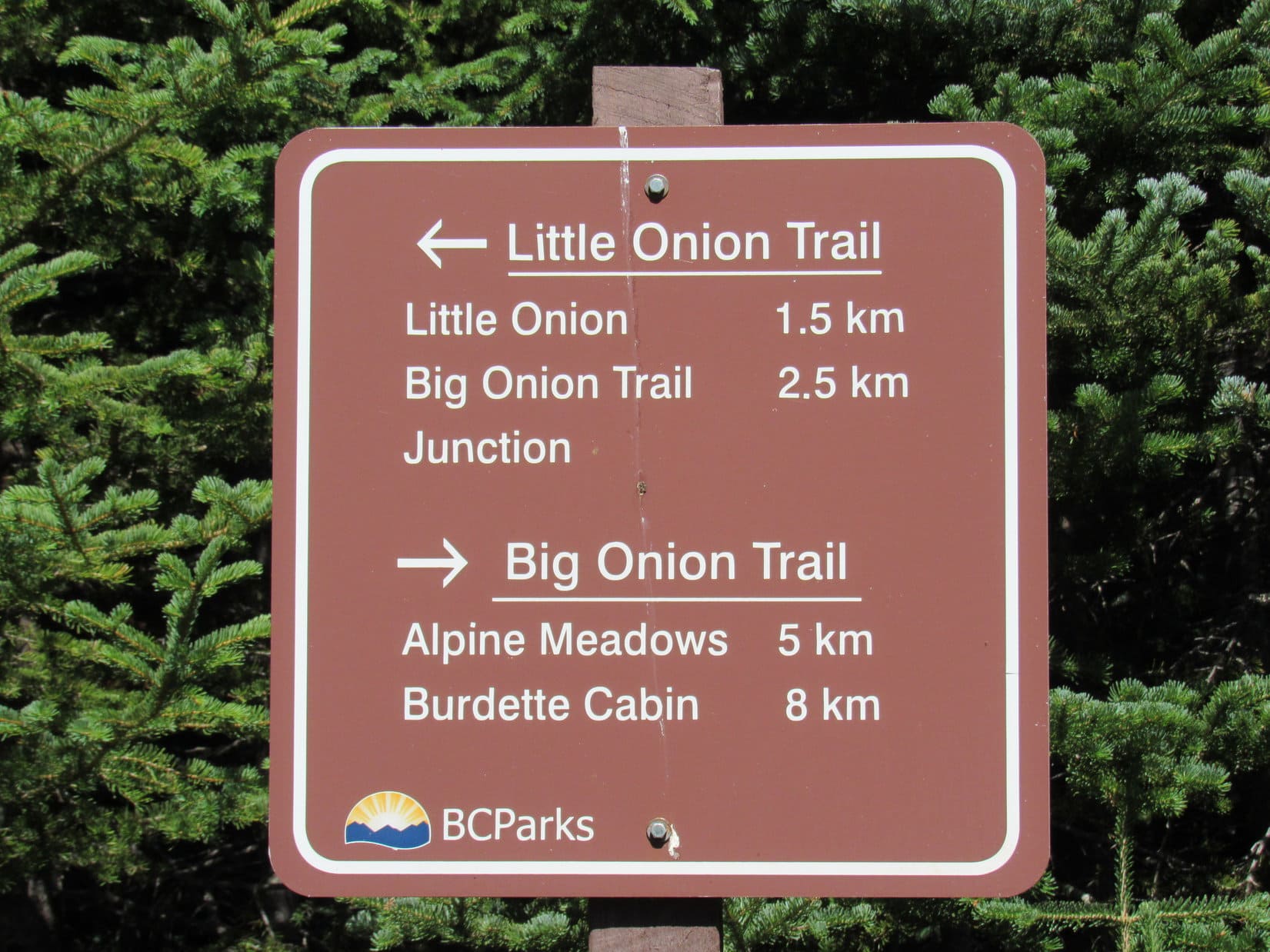
This junction was the official end of the Little Onion Trail. Looper kept going N, now taking the Big Onion Trail toward Alpine Meadows.
Sign at the end of the Little Onion Trail. Lupe kept going N toward Alpine Meadows.
A little farther on, the Carolina Dog reached another signed junction. This was the critical one! Lupe had no intention of going all the way to Alpine Meadows. That wasn’t the way to Astlais Mountain or The Big Onion.
At this second junction, a road went W back up onto the ridge leading to The Big Onion. The sign said this road was the Astlais Mountain Trail. The pass below Astlais Mountain was 1.4 km away.
Great news! That was exactly where Lupe needed to go!
Sign at the critical junction. Lupe abandoned the Big Onion Trail in favor of the Astlais Mountain Trail here.
So Lupe abandoned The Big Onion Trail, and took the Astlais Mountain Trail W up onto the ridge. Once on the ridge, the road turned N, then subsequently deteriorated to the point where it would be impassable for any vehicle other than an ATV, or perhaps a snowmobile in winter.
The trail did go on, however, and went through a low area where Lupe came to the only water to be found all day. A trickle of a stream formed from little seeping springs ran over the road here, just enough for the Carolina Dog to get a drink. Beyond this point the trail gained elevation at a moderate pace, heading NNW along the SW slope of The Big Onion, but still far below the summit.
The Astlais Mountain Trail along SW slopes of The Big Onion. Photo looks NNW.Looking back toward The Little Onion. Photo looks SSE.Looper on the Astlais Mountain Trail. The Little Onion at Center. Photo looks SSE.Hudson Bay Mountain from the Astlais Mountain Trail. Photo looks W.
Worries that the trail might fade away completely proved unfounded. A much better road soon came in from somewhere off to the SW, and swung sharply around continuing toward the high saddle between The Big Onion and Astlais Mountain.
Luck of the Dingo again! This road will get us up to the pass! Photo looks NW at Astlais Mountain.
The new road promptly began climbing at an incredible pace along the very steep W slopes of The Big Onion. Lupe had no troubles, but SPHP lost traction on any loose debris to the point where walking wherever the ground looked firmest, or in piles of loose rock thick enough to offer at least some support, became standard practice.
The mere thought of being in a vehicle going up or down this road was rather frightening to contemplate. Being on paw and foot was certainly much better, even if the long trudge higher was exhausting.
Well, it is a mountain road, SPHP! What did you expect? Photo looks NNW.Whew! That was sort of steep, wasn’t it? Glad that’s over with! Photo looks SSE.
It was a huge relief when the road finally began to level out. Lupe had made it to the high pass between Astlais Mountain and The Big Onion! Beyond the pass, she could see higher peaks to the N for the first time. Those peaks were in Babine Mountains Provincial Park.
We’ve made it to the end of the Astlais Mountain Trail! Those mountains to the N are in Babine Mountains Provincial Park. Photo looks N.
After a rest break, the only question now was which to climb first – The Big Onion or Astlais Mountain? Both looked like big hills, basically easy climbs from here. The Big Onion was closer and lower. After initially starting that way, SPHP changed the plan.
Still a lovely day, but more clouds were present than only a little while ago. Maybe Lupe ought to take on Astlais Mountain first? Would be nice to get the higher peak in case the weather deteriorated fast enough to prevent the American Dingo from visiting both. Whatever! Lupe was fine with that.
By the time Lupe was getting close to the high saddle, The Big Onion (Center) wasn’t that much higher. Photo looks SE.Astlais Mountain looks like just a big hill from here! Photo looks WNW.Astlais Mountain from the high saddle. Photo looks W.
So Lupe charged up the E slope of Astlais Mountain, while SPHP plodded higher. It hadn’t looked this steep! Nevertheless, this was just a big grassy trudge until fairly close to the top. The terrain then began to get rockier as the slope decreased. The huge summit region was somewhat complex with various rocky knobs and ridges among areas of tundra or bare ground consisting of small loose rock.
It wasn’t immediately clear where the summit was, but a big cairn was soon spotted well W of where Lupe had come up.
Lupe already reaching the easy terrain close to the top of Astlais Mountain.Which way do you think, SPHP? Gotta be one of these rocky high points, but which one? Photo looks S.Oh, I think I see it! There’s a big cairn (R) over this way! Photo looks WNW.Lupe near the summit. Photo looks WNW.Yes, this is it! Almost there!
The weather hadn’t deteriorated at all during the time it took Lupe to reach the big summit cairn on Astlais Mountain(6,037 ft.). 60°F with a 10 to 15 mph SW breeze, just like at The Little Onion. A beautiful day! Which was great news. Lupe could stay a while!
Loop reaches the summit of Astlais Mountain. Photo looks NNW.Loop at the summit cairn. Photo looks NW.Hudson Bay Mountain (L) from Astlais Mountain. Photo looks W.Another look showing more of the W end of the summit area. Hudson Bay Mountain (Center R) beyond Lupe. Photo looks WSW.A closer look at the W portion of the greater summit area. Lupe didn’t venture all the way over there. Hudson Bay Mountain on the R. Photo looks WSW.Here’s the last stretch of the summit region the way we came up! Photo looks ESE.
Hudson Bay Mountain(8,494 ft.) and the other rugged more distant peaks to the SW and NW were all just as beautiful and interesting as they had been from The Little Onion, but the views really weren’t much different in those directions from Astlais Mountain.
Hudson Bay Mountain from Astlais Mountain with help from the telephoto lens. Photo looks W.Looking NW with help from the telephoto lens.Part of Tyhee Lake (the larger lake R of Center) near Telkwa is in view. Photo looks SW.Rugged peaks far to the SW with help from the telephoto lens.
The Little Onion(5,220 ft.), which had seemed such an impressive high point only a short while ago, looked small and much lower from Astlais Mountain. Lupe could see part of The Little Onion trail on the N slopes.
The Little Onion (Center) did look little from Astlais Mountain. Photo looks SSE.The Little Onion with help from the telephoto lens. Photo looks SSE.
Smoke from the forest fires to the S could be seen actually billowing up. The wind must still have been out of the SW way over there, too. A huge plume was drifting NE.
A huge plume of smoke billows up (Center R) and drifts off to the NE (L). Photo looks S.
Though Lupe had seen essentially these same views in most directions from The Little Onion, coming to Astlais Mountain had been worthwhile, for off to the N the scene was much different. The American Dingo now had a tremendous view of closer peaks in Babine Mountains Provincial Park (map).
Lupe and SPHP spent a long time gazing N at the splendors on display. SPHP knew the names of a few of the peaks. The Galleon(7,844 ft.) was the most impressive from Astlais Mountain. SPHP scanned the horizon for Mount Cronin(7,861 ft.), and thought Lupe had a glimpse of it, though partially hidden by Mount Hyland (7,478 ft.).
Lupe gazing across Ganokwa Basin toward the high peaks of the Babine Mountains. Photo looks N.The Galleon (Center) was the most impressive peak Lupe saw from Astlais Mountain. Photo looks N with help from the telephoto lens.Another look across Ganokwa Basin. SPHP believes the high dark ridge at Center is Mount Hyland. The distant dark ridge L of Center which is only partially in view is likely part of Mount Cronin. The Galleon is at far L. Photo looks NNE.Still looking NNE, but with help from the telephoto lens. Mount Cronin is the ridge in shadow L of Center. Mount Hyland is the dark ridge on the R.Perhaps a clearer view. Mount Cronin’s summit may be the distant sunlit little bump at Center. Mount Hyland at far R. Ganokwa Basin in the foreground. Photo looks NNE.Zoomed in on Mount Hyland. Photo looks NNE.Mount Hyland on the L. The distant spire at Center is likely High Point 6470 (1972 M). Photo looks NNE.
The highest peaks weren’t the only ones of interest. Nearly a year ago Lupe had climbed Harvey Mountain(6,083 ft.), which was off to the NNW. It would have been fun to see Harvey Mountain again, but as it turned out, Padella Peak (6,300 ft.) was in the way.
Perhaps looking for Harvey Mountain, Lupe gazes across a deep canyon toward Padella Peak (L in foreground). Pyramid Mountain (6,234 ft.) is the lower sunlit peak just to the R of Padella. The Galleon is in the distance at Center. Photo looks N.Padella Peak (Center) from Astlais Mountain. Pyramid Mountain in the foreground on the R. Photo looks NNW.Padella Peak (R). Lagopus Mountain (6,956 ft.) (Center) is in view beyond Padella. Photo looks NNW.Isn’t Astlais Mountain great? So much to see! Photo looks NE.Lagopus Mountain (far L), Padella Peak (L), Pyramid Mountain (Center L), and The Galleon (Center). Photo looks N.
Astlais Mountain was a fantastic peak! Such a great day, and so much to see from here! 50 glorious minutes shot by at the summit. If Lupe still wanted to visit The Big Onion, too, which she did, it was getting to be time to bid farewell to Astlais. A final look at the mighty Galleon, and the Carolina Dog was on her way.
The Galleon (Center) from Astlais Mountain. Photo looks N.Sadly, it’s time to leave Astlais Mountain if we’re going to visit The Big Onion, too. Our stay here has been splendid, hasn’t it? Photo looks NNW.Final moments at the summit of Astlais Mountain. Photo looks NNW.Astlais Mountain’s N ridge as seen from the summit is in the foreground. Lupe would head down this way after a quick jaunt to the R (S) for a view of The Big Onion before completing her descent. Mt. McKendrick is at far R. Photo looks ENE.Looking back at the summit of Astlais Mountain (R). Hudson Bay Mountain (Center). Photo looks W.
Upon leaving the summit cairn, Lupe headed E to a high point where she could look down on The Big Onion(5,840 ft.). She then headed N a little way losing elevation gradually, before turning E and descending the much steeper slope to the saddle.
Looking down on the saddle leading to The Big Onion (R). Mt. McKendrick (L) in the distance. Photo looks E.Looking back up at the summit of Astlais Mountain near the start of Lupe’s descent. Photo looks SW.The Big Onion (R) as seen before beginning the steepest part of the descent. Photo looks SE.Won’t be long now! Soon we’ll be at the top of The Big Onion! Photo looks SE.
Once down, Lupe crossed the saddle and headed for The Big Onion. She followed a road part of the way, and eventually reached the ridgeline a little way N of the summit. An easy, short trek S along the narrow ridge brought the American Dingo to the top of The Big Onion(5,840 ft.).
This is it! We’ve arrived at the true summit of The Big Onion. Quite a view of Astlais Mountain behind me, isn’t it? Photo looks WNW.
The absolute high point consisted of several medium-sized rocks amid tufts of brown grass. The summit was a mostly grassy area atop a rocky knob which dropped off steeply, though not precipitously.
The Big Onion wasn’t high enough to give Lupe quite as grand a view of the heart of the Babine Mountains to the N as she’d had from Astlais Mountain. However, she could see more territory to the E, and the view of Astlais Mountain itself was quite interesting.
Lupe at the true summit of The Big Onion. Hudson Bay Mountain (L) in the distance. Astlais Mountain (R). Photo looks W.View along The Big Onion’s N ridge. The Galleon is on the L. Mount Hyland on the R. Photo looks N.View to the NNE. Mount Hyland on the L.Mount Hyland (Center) with help from the telephoto lens. Photo looks N.Looking over the saddle between The Big Onion and Astlais Mountain toward Padella Peak (Center). Pyramid Mountain is on the R with Lagopus Mountain peeping up between Padella and Pyramid. Photo looks NW.Looking S. The Little Onion is on the L.The Little Onion (Center) from The Big Onion. Photo looks S.A view of the entire saddle area between The Big Onion and Astlais Mountain (L). Padella Peak on the R. Photo looks NW.Loop relaxing on The Big Onion summit. Photo looks WNW.Mt. McKendrick (R). Photo looks ENE.The Galleon (Center) from The Big Onion. Padella Peak (L) and Mount Hyland (R). Photo looks N.
Lupe relaxed and enjoyed the beautiful Babine Mountains from the top of The Big Onion for half an hour. Her journey to Astlais Mountain and both Onions had been a huge success! The day had gone far better than SPHP had ever dared to hope. Evening was approaching, however. Lupe began the trek back to the Onion Mountain trailhead.
Lupe on The Big Onion shortly before departure. Photo looks SSW.
Lupe’s route back was the same one she’d taken up. The Carolina Dog and SPHP were both in high spirits. The return trip went fast. So fast, in fact, that Loop returned briefly to the summit of The Little Onion. Even after visiting The Big Onion and Astlais Mountain, The Little Onion was still an amazing place! And far to the S, the smoke of distant fires still billowed into the sky.
Then it was down, down, all the way back to the trailhead. (7:26 PM)
Final moments atop The Big Onion. Photo looks S.Hardy little tundra plants on The Big Onion’s N ridge.Here we go again on the Astlais Mountain Trail! Thankfully we’re heading down this time. Photo looks SSE.Forest fires still burned as evening approached. Looking S from The Little Onion.
SPHP stopped in Smithers for fuel and dinner from Safeway. Twilight was coming on by the time Lupe arrived at a big field along Yellowhead Hwy 16 S of Moricetown. Ancient picnic tables with white peeling paint stood on a bluff overlooking the Bulkley River.
Despite her long afternoon in the Babine Mountains, the American Dingo was still energized. She raced around the G6 playing chase with SPHP, who was, as always, totally outmatched. Lupe was happy, oh, so very happy! And seeing her so, SPHP shared her joy. What a wonderful day this had been!
Lupe on The Little Onion again, Babine Mountains, British Columbia, Canada 8-8-18