
Part 1 of Day 3 of Lupe’s 2017 Dingo Vacation to the Yukon & Alaska!
August, yet Banff was quiet and cool. Low clouds hid the mountains. Only a few people were wandering about this early in the normally bustling tourist town. Summer had vanished. It felt a little like fall with winter on the way. Lupe & SPHP left Banff heading W on Trans-Canada Hwy 1. (5:44 AM, 52°F)
Not until Lupe was well N of Lake Louise on Icefields Parkway Hwy 93 did the clouds begin to dissipate. The sky was clear by the time she reached the picnic ground at Bow Lake.

After 2 days spent almost entirely on the road, Lupe needed to get out of the G6 and do something active for a while. The Canadian Rockies are a perfect place for that! One of the most beautiful short day hikes was right here at Bow Lake. With the sun out now, the morning would warm up fast. It was still early enough for Lupe to beat the hordes of tourists certain to appear before too long.
SPHP drove over to the N side of Bow Lake, parking the G6 at Simpson’s Num-Ti-Jah Lodge (7:16 AM). The big gravel parking lot at the trailhead for Bow Glacier Falls was practically empty, but would be overflowing soon enough on a day like this. Before hitting the trail, Lupe went down to the N shore of Bow Lake. Wisps of fog lingered over the smooth, still waters. Lupe could see Bow Peak (9,318 ft.) and part of the Crowfoot Glacier across the lake.

Bow Glacier Falls, Lupe’s ultimate destination, was already in view to the SW. From a distance like this, Lupe could even see part of the Bow Glacier, an arm of the massive Wapta Icefield, above the falls.


On her way to the trail, Lupe passed by Simpson’s Num-Ti-Jah lodge with its distinctive red roof.


The first part of the trek to Bow Glacier Falls went W right along the N shore of Bow Lake. The easy, level trail gradually turned SW. The views were stunning from the very start.


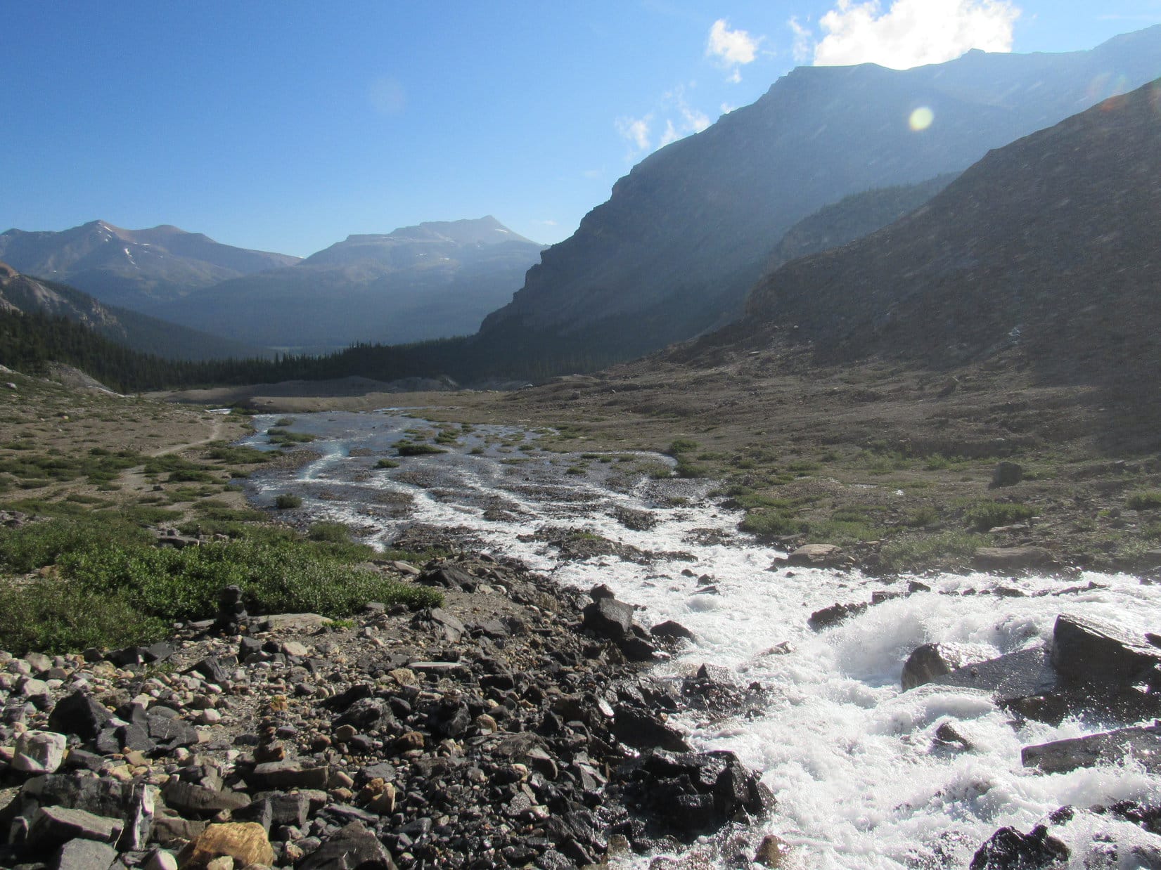
By the time Lupe reached the W end of Bow Lake, Bow Glacier Falls had sunk out of sight behind a forested ridge. The trail now went SSW following a swift glacier-fed stream. The stream was braided where it flowed into Bow Lake.

Following the stream was super easy. The trail stayed close to the W bank, but never crossed the river. In some places cairns marked the way, but they weren’t needed, since it was always obvious where the trail was headed. Other than one short stretch where the stream forced the trail into the forest, the terrain was level the entire way to a set of stairs at the base of a forested ridge.


The only steep section of the whole Bow Glacier Falls trail began with the stairs at the base of the forested ridge. During this climb, which didn’t take Looper long, the stream was only occasionally in sight. It could always be heard, though, rushing in a roaring torrent through a deep, narrow chasm nearby.
Once up on the forested ridge, Lupe had a panoramic view of what lay ahead from a bare spot along the edge of the far side. Below her, two pale blue glacial streams joined forces to form the larger stream that disappeared immediately into the chasm. One of these smaller streams flowed down from snowfields hidden in an intriguing, mysterious valley to the S. The other stream came from Bow Glacier Falls, which was now in sight again at the far end of a large rocky amphitheater to the SW.


Continuing on, Lupe lost a little elevation as the trail descended the other side of the forested ridge into the lower end of the amphitheater below Bow Glacier Falls. Once in the amphitheater, it was a simple matter to follow the trail up toward the base of the falls.
The Bow Glacial Falls trail became braided and ultimately disintegrated before actually reaching the falls, but the waterfall was always in sight directly ahead. The rest of the way, Loop sniffed and explored her way among rocks and two inch deep streams that trickled everywhere.


An hour and twenty minutes after leaving Num-Ti-Jah lodge at Bow Lake, Lupe arrived at the base of the falls. Not a soul was around. Due to her early morning start, Looper hadn’t seen anyone else on the whole trail. The coveted solitude wasn’t likely to last long. The Bow Glacier Falls trail is so accessible, easy, and scenic from start to finish that it is one of the most popular short day hikes in the Canadian Rockies.

Of course, the first thing to do was to climb up next to the falls about as high as seemed reasonably safe.


Bow Glacier Falls was spectacular, but the views back down the valley were amazing, too!
Lupe and SPHP scrambled around a bit more to get a little higher. The terrain wasn’t that difficult, but some of the rocks were very slick with water trickling down over them. Loopster did manage to get somewhat higher than before. The difference in elevation was enough so the Carolina Dog could now see the W end of Bow Lake.


Lupe climbed about as far up as the Carolina Dog could reasonably go. Most of rocks above her were wet and slippery. SPHP decided she had gone far enough. Bow Glacier Falls flows down from an unseen upper lake located below Bow Glacier. It would have been great fun to get up above the falls to see the upper lake and the glacier, but a solid line of cliffs ruled out any possibility of doing that.
Amid the grandeur of the Canadian Rockies, Lupe and SPHP took a 30 minute break on the dry parts of a rock ledge. The day had warmed up nicely. Lupe didn’t have a care in the world. SPHP filled 3 water bottles with water from the Bow Glacier which had tumbled over the falls. Lupe munched Taste of the Wild, and enjoyed being petted.
The glorious solitude lasted longer than SPHP expected it would, but inevitably people were seen coming up the trail. The time had arrived to think about moving on.


After 50 minutes of glorious solitude at Bow Glacier Falls, Lupe and SPHP started down. Lupe paused along the edge of the falls once or twice for photos, then it was time to hit the trail. People were getting close.


 A hiker in one of the first groups Lupe passed on her way down told SPHP that a side trail existed that went all the way up Mount Jimmy Simpson (9,731 ft.). The side trail left the main trail down at the forested ridge, and wasn’t hard to find. That sounded great! SPHP was interested immediately. Lupe should do that today, right now!


Searching for the trail up Mount Jimmy Simpson, Lupe and SPHP tried several side trails on or near the forested ridge. None went far. They all quickly faded away in dense forest on steep slopes. Hmm. The hiker had said the correct side trail was easy to find. Easy perhaps, if one knew exactly where to look.
By now, throngs of hikers were heading up to Bow Glacier Falls. SPHP asked some of them if they knew anything about a trail to Mount Jimmy Simpson? No one, not even experienced professional guides leading large groups, had a clue. Few had even heard of Mount Jimmy Simpson. Disappointed, SPHP gave up on the idea.
Lupe remained cheerful, however. The trek to Bow Glacier Falls had been perfect! The scenery was stunning the entire way, and she’d had a lot of fun sniffing around and getting some exercise. Now on on the way back, she was getting to see and do it all over again.


Before noon, Lupe was back at Num-Ti-Jah lodge. Even with almost an hour spent relaxing near the falls, and the failed search for the side trail to Mount Jimmy Simpson, the whole trek to Bow Glacier Falls and back had taken only a little over 4 hours.
The trail to Bow Glacier Falls had been a grand time. The American Dingo had enjoyed a wonderful needed break from the G6, and seen a favorite part of the glorious Canadian Rockies again. She was now ready to continue the long journey N on the way to her next adventure.

Related Links:
Bow Lake & the Trail to Bow Glacier Falls, Banff National Park, Canada (7-25-13)
Cirque Peak, Banff National Park, Canada (7-27-14)
Want more Lupe adventures? Choose from Lupe’s 2017 Dingo Vacation to the Yukon & Alaska Adventure Index, Dingo Vacations Adventure Index or Master Adventure Index. Or subscribe free to new Lupe adventures.


