Lupe was delirious with delight! The shocking news SPHP had just given her was so incredibly wonderful! Why, Christmas was coming! Not only that, but Cousin Dusty and Uncle Joe were in town all the way from Colorado. Cousin Mark had even come with them. They all wanted to go on a Black Hills Expedition with Loop. Nothing too fancy or long, but enough to get a workout and see a few sights.
Was the American Dingo up for that? Oh, boy! Was she ever! She barked and leapt at SPHP. What’s the holdup? Let’s go right now!
Loopster raced through the front door of Grandma’s house and greeted everyone with great joy and energy. It was true! They were all here! Dusty was instantly excited, too, and responded in kind. Greetings all around. Dusty and Lupe both looked at SPHP expectantly. Oh, yeah. They both knew that Grandma had a big bag of Beggin’ Strips downstairs. Of course, they each got one. Sly dingo Loop grabbed two.
Start – 9:51 AM, 27°F at the junction of Highway 385 & USFS Road No. 710
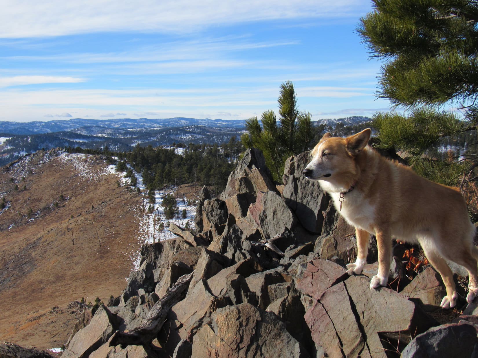
Kind of cold and snowy, but this was a good spot for a quick romp in the hills. Peak5917 was only a little more than a mile away. Several options from there depending how things were going. With minimal delay the whole gang started up No. 710. The road headed W up a shady valley N of Peak5800. Cousin Dusty led the way.
Setting out for Peak 5917 on USFS Road No. 710. Uncle Joe with Cousin Dusty. Cousin Mark with Lupe.Cousin Dusty leads the way.
After 0.75 mile on No. 710, the road reached the upper end of the valley. The terrain flattened out. No snow here. The road curved S passing through an open stand of tall Ponderosa pines.
Lupe’s entourage reaches the open stand of Ponderosa pines at the upper end of the valley. Photo looks SW.
Beyond the pines the road turned W again, and began to fade. Ahead was a region of grasslands dotted with scattered pines. Peak5917 was already in sight.
Beyond the tall pines, heading for Peak 5917 (R). Photo looks W.
Soon everyone was on the way up Peak 5917’s SE slope. Mark and Dusty were out in front.
Cousins Mark & Dusty led the way up.Joe pauses to look back. The tall pines are at the far edge of the grasslands beyond him. Peak 5800 is on the R. Photo looks ESE.
Mark and Dusty reached the summit well before Joe, Lupe and SPHP caught up.
Cousin Mark atop Peak 5917. Mark is a Dance Dance Revolution champion who competes in tournaments. No wonder he was stepping so lively!Joe and Dusty join Mark at the summit. Photo looks N.Mark & Joe at the summit of Peak 5917. A triumph of sorts. They’re from Colorado. Maybe they’ve been on an even loftier peak once or twice before? Part of Pactola Reservoir (R) is in the background. Photo looks NNE.Lupe’s turn on the highest rocks while getting a pat from Mark. New Year’s Eve Peak is in view beyond her. Photo looks W.
December. Not especially cold, but definitely cool out. A chilly breeze was blowing out of the W. Prior to leaving Peak 5917, a group photo was hastily arranged.
L to R – Mark, Dusty, Lupe & Joe. Five Points(6,221 ft.) is a little L of Mark, and conical False North Point(6,130 ft.) is R of him. Pistol Point (5,880 ft.) is at the far end of the half grassy, half forested ridge on the R. Photo looks SW.
What now? Was everyone done? The closest options for extending the trek were New Year’s Eve Peak(6,046 ft.) a mile NW as the ridges went, go only halfway there to Pistol Point, or head SE back to Peak5800.
Pistol Point sounded good to everyone. Mark, Dusty and Joe started down Peak 5917’s SW slope. Loop lingered briefly at the summit before following after them.
Looper lingers in the chilly W breeze atop Peak 5917. New Year’s Eve Peak (L) in the distance. Lupe had been there only 5 days ago on Expedition No. 242. Photo looks NW.Mark, Dusty & Joe start down the SW slope. Black Elk Peak(7,231 ft.) (L), Five Points (Center) and False North Point (R) are all in sight. Photo looks SSW.Pistol Point is at the far end of the half grassy ridge on the L. Photo looks W.
Pistol Point is only 0.5 mile SW of Peak 5917. Cousin Mark was soon poised atop the rocky ridge.
Heading up to Pistol Point. Photo looks W.Mark poised atop the rock formations at Pistol Point while Joe takes a photo. Lupe is standing over near the rock resembling the handle of a pistol jammed into the ground that Pistol Point is named for. Photo looks ENE.Cousin Mark staying hydrated.Mark and Dusty relax for a moment taking in the views. Photo looks SE.Joe and Lupe take a turn up on the rocks. Photo looks W.
Pistol Point offers the same sweeping 180° views to the S that Peak 5917 does from only a slightly different perspective. The W wind was still chilly. If it hadn’t been for the breeze, New Year’s Eve Peak, only 0.5 mile NW, probably would have happened.
As it was, though, Cousin Dusty was shivering. At 12 years old, she was doing great to have come this far leading the way most of the time. Best to head back, though, to get her out of the cold wind.
Group photo at Pistol Point shortly before departure. Mark and Lupe on the L. Joe and Dusty on the R. Photo looks SW.Peak 5917 from Pistol Point. Photo looks NE.Joe and Dusty start down. Peak 5917 (L) and Peak 5800 (R). Photo looks ENE.
Dusty felt better as soon as she was out of the wind. The trek back to the G6 was scenic with great company to share the day with. The route back was the same, minus an excursion up to Peak 5917 again.
Dusty leads as Mark and Joe follow her down. Peak 5800 (R). Photo looks ENE.A momentary pause while Joe checks his phone. Part of Sheridan Lake is seen beyond Dusty.Calumet Ridge(5,601 ft.) is beyond the lake. Silver Mountain(5,405 ft.) is L of Calumet Ridge. Photo looks SE.Another pause on the return. Peak 5800 (Center). Photo looks ESE.Lupe in familiar territory. Nearly every year she makes a pilgrimage to New Year’s Eve Peak coming this way. Boulder Hill(5,331 ft.) (R) is the prominent knob far beyond her. Peak 5800 (L). Photo looks SE.Dusty having a good time in the Black Hills now that she’s out of the wind.Back on the road in the tall pines area. Photo looks E.
Before long, everyone was heading down the valley on snowy USFS Road No. 710. A ride back to Grandma’s house for goodies and more fun was waiting at the end of the road. Best of all, the festivities would continue for the next several days, because, you know, Christmas was coming! (12:52 PM, 29°F)
Mark, Joe, Dusty & Lupe on USFS Road No. 710, Black Hills of South Dakota 12-22-18
Day 3 of Lupe’s 2018 Dingo Vacation to the Bighorn Mountains & Wind River Range in Wyoming
7-15-18, the wee hours, Gunboat Lake – The crisis struck when Lupe woke SPHP up. She wanted out of her new Marmot tiny house. No telling what time it was. SPHP let her go. The American Dingo shot off into the night. No stars. The silent night was pitch black. Must be cloudy.
Loop was back soon enough, and settled down to snooze some more. Though profoundly weary, SPHP couldn’t. Those faint flashes of light, were they real or imaginary? SPHP listened. Nothing. Eventually two brighter flashes were conclusive. Lightning!
Was a storm bearing down upon Gunboat Lake? Was the weather going to be rotten in the morning, destroying Lupe’s chances of ever making it up Bomber Mountain (12,840 ft.)? Even if it wasn’t, how was SPHP ever going to accompany her up there feeling so pathetically drained and weak?
The mind raced. Fears multiplied. Real or imaginary? Potentially either, perhaps, but unrealized yet. Low blood sugar was fueling the fear. Nuts and applesauce! Get that blood sugar back up! A couple of hours of mental failing went by. SPHP fell into a deep sleep.
7-15-18, 7:32 AM – Heh. When even the Carolina Dog is sleeping in, you know it had been a long day! The morning news was all good, though. No storm had ever materialized. Sunshine, in fact! Scarcely a cloud in the sky. Gunboat Lake sparkled. Bomber Mountain loomed off to the NE, daring the American Dingo to try it. SPHP was still fatigued, but yeah – a perfect day! Weary or not, Loopster was gonna do this!
Loop sacked out in her brand new Marmot tiny house. Gathering strength for Bomber Mountain, ya’ know!
Slowly SPHP got ready. At least the Marmot tiny house and sleeping bags could be left here at Gunboat Lake. A lighter pack would help a lot.
Miss Sleepyhead revived and made her appearance. She was moving a bit slowly, too. Loop sniffed around lazily and stretched. Didn’t appear she was in any great hurry to go anywhere. Understandable. This little ridge overlooking Gunboat Lake was a glorious place to be!
Miss Sleepyhead makes a leisurely appearance. Gunboat Lake is on the R. One of the smaller Fortress Lakes on the L. Bomber Mountain is in the distance on the L. The valley at Center leads to Florence Pass. Photo looks NE.Gunboat Lake on the L. Peak10860 in the distance on the R. Photo looks SW.
Before long the pack was ready, even if SPHP wasn’t. Feeling it or not, Lupe was on her way!
Loop at base camp prior to departure for Bomber Mountain (L). Photo looks NE.
Being on the move again put a spring in Lupe’s step. Her energy came surging back. Nose to the ground, she raced along sniffing everywhere. Instead of heading straight for the Solitude Trail to Florence Pass, Looper went down to explore the NE shore of Gunboat Lake first. Gunboat Lake was gorgeous!
The NE end of Gunboat Lake sparkles in the morning sunshine. Photo looks E.Loop by Gunboat Lake, a favorite spot in the Bighorn Mountains. Photo looks SSW.Looking along the length of Gunboat Lake. Peak 10860 in the distance on the R. Photo looks SW.
From the NE end of Gunboat Lake, it wasn’t far to the Solitude Trail. The trail was good all the way to Florence Pass (10,900 ft.) 0.75 mile from camp. Florence Lake came into sight as soon as Lupe reached the pass.
NE of Gunboat Lake. The Solitude Trail goes up the valley ahead before curving to the L (N) where it reaches Florence Pass beyond the hill seen on the L. Photo looks NE.At Florence Pass. Florence Lake dead ahead! Photo looks N.
Florence Lake nestles just N of Florence Pass in a spectacular setting! The whole N shore of Florence Lake was surrounded by massive ridges, all part of the SW reaches of Bomber Mountain(12,840 ft.). A waterfall plunged noisily into the NE corner of the lake.
Upon reaching Florence Pass, the Solitude Trail turned ESE staying well above the lake’s S shore. North Clear Creek flows out of the SE end of Florence Lake. When Lupe got to where she could see the outlet, the views were encouraging!
Though a big stream, North Clear Creek was chock full of rocks. Looper ought to be able to rock hop it! The headwall beyond North Clear Creek was steep, but definitely climbable. Situation excellent! Lupe headed for North Clear Creek.
E end of Florence Lake. Golden Lakes are up in the canyon beyond the headwall on the far shore. The waterfall is difficult to discern, but plunges from the low cliffs L of Center directly into the lake. The North Clear Creek outlet is just out of sight to the R. Photo looks NE.North Clear Creek leaves Florence Lake from the area directly beyond Lupe. Once across the stream, Loop would climb the headwall on the other side staying mostly in the green areas toward the R. Photo looks NE.The upper end of Florence Canyon from the S bank of North Clear Creek as it exits Florence Lake. Photo looks SE.
Lupe was across North Clear Creek in nothing flat. SPHP wasn’t nearly so agile, but rock hopped it, too. Wondering what was taking so long, Loop came partway back to give SPHP encouragement.
North Clear Creek outlet from Florence Lake. Lupe shot across across the rock-choked stream in no time at all. She’s the brown speck on the R at the edge of the greenery on the N bank. Photo looks NNE.Florence Lake from the North Clear Creek outlet. Photo looks W.
Once across North Clear Creek, the easy part was over. The Solitude Trail turned ESE disappearing down Florence Canyon. A relentless trek higher was about to begin. More than 2.5 miles and 2,000 vertical feet of up, all the way to the as yet unseen summit of Bomber Mountain.
The first step was to get up the 300 foot high headwall NE of Florence Lake. The climb was steep, but not bad. Lanes of vegetation allowed Lupe to avoid much more difficult areas of nothing but rock. The worst part was simply how played out SPHP felt from yesterday’s long march to Gunboat Lake. Starting off tired wasn’t good. Bomber Mountain was going to be a long, long day.
A spectacular day, though! The view of Florence Lake from the top of the headwall was amazing.
Florence Lake from the headwall. North Clear Creek is below on the L. Florence Pass is L of the big snow bank farthest L on the opposite shore. Base camp at Gunboat Lake is out of sight below the dark distant ridge on the L. Photo looks SW.
The original intention was to go up the big canyon NE of the headwall at least far enough to see the Golden Lakes from High Point 11328. Lupe started off that way, but the terrain was really rough. Patches of green here and there, but mostly broken rock. Progress was slow despite not gaining much elevation.
Heading up the canyon NE of the headwall. The intention was to go far enough to see the Golden Lakes from High Point 11328 (in view within the canyon a little R of Center – topo map). Photo looks NE.
Loop got fairly close to High Point 11328 before SPHP decided it wasn’t worth the effort. The Carolina Dog was no longer rock hopping, but scrambling among huge boulders. She was good at it, but SPHP was barely moving. Wasting too much time! Better get above all this giant debris.
Abandoning the High Point 11328 idea, Lupe scrambled E directly up the side of the canyon. Also slow going at first, but no worse than down below and at least getting higher. Conditions began to improve. Scattered green lanes of vegetation appeared. Making progress again! Heart, lungs, and legs dictated the pace instead of obstacles.
This is way better than down among all those huge boulders! Photo looks ENE.
Lupe never did see the Golden Lakes on the way up. She was too far E. The climb went on and on, but this was the worst of it. Loop must have been feeling the effects of yesterday’s long march, too. She wanted to stop often to rest and be petted.
SPHP could hardly disagree. The danger was in sitting around too long. Would be so easy to simply get wrapped up in relaxing and enjoying the views, and end up proceeding too slowly to ever get there. SPHP tried to keep the rest breaks short.
Puppy, ho! Onward! Rinse and repeat. Endlessly.
The views became ever more impressive. Gradually the going became easier. The slope of the terrain was slackening. Good thing. Despite, or perhaps because of the glorious surroundings, energy was fading, too. The terrain led Lupe to turn more and more to the NE, then NNE.
A high point that had been visible from way back at base camp was off to the N. It was still far away, but Lupe was definitely getting closer. Was that the summit of Bomber Mountain? If not, it had to be close to it, didn’t it?
Getting easier, but still a long way to the high point at Center that might be the summit of Bomber Mountain. Golden Lakes, which Lupe never saw on the way up, are hidden down in the canyon on the L. High Point 12436 is the lower of the 2 ridges at far R. Photo looks N.
Higher, higher! Vegetation all but disappeared. Nothing but rock.
At each rest break, SPHP tried to judge how high Lupe was by comparing her position with other mountaintops where the elevation was known. Finally, it was possible to see that Looper was getting nearly as high as Mather Peaks(12,400 ft.) off to the S. This had to be High Point 12436 on the topo map that Loop was coming to.
Approaching High Point 12436. Still 0.75 mile S of the summit of Bomber Mountain. Photo looks NE.Mather Peaks(12,400 ft.) are the two high points on the L. Peak 12328 is on the R. It had looked possible to access these peaks from the ridge SE of Florence Lake. Photo looks S.
Lupe got very close to the top of High Point 12346, but passed W of it. She actually lost elevation heading NW around cliffs to the N. By now a small distant ridge E of the high point SPHP had thought might be the summit of Bomber Mountain was in view.
That distant ridge was it! The true summit of Bomber Mountain. Only 0.75 mile away now! Tired, very tired, but Lupe was going to get there!
W of High Point 12436, the true summit of Bomber Mountain comes into view (R). Photo looks N.A steep snowbank clings to cliffs N of High Point 12436. True summit of Bomber Mountain (Center) dead ahead. Photo looks N.Near the steep snowbank N of High Point 12436. Photo looks E.Peering down the canyon E of High Point 12436 (R). The northernmost of the Powell Lakes is in view. Photo looks SE.
N of High Point 12436 a huge, narrow ridge extended far to the E. This ridge was nearly as high as the summit of Bomber Mountain, still 0.5 mile farther N. Towering cliffs surrounded the ridge, and ran all along the entire E face of Bomber Mountain.
A 12,580 ft. saddle N of the scary E ridge led to the summit of Bomber Mountain. The rocks got smaller and the terrain easier as Lupe made her way toward it. She crossed a snowfield on the way, but it wasn’t steep. Upon reaching the saddle, Lupe could see Lake 11124 and a string of smaller ones off to the NE.
Loop relaxes 0.5 mile from the summit. Part of Bomber Mountain’s giant SW ridge is in view. Photo looks WSW.At the 12,580 ft. saddle. Bomber Mountain’s E ridge is on the R. Lake 11124 is the closest one below. The large lake in the distance is Cloud Peak Reservoir. Photo looks NE.
0.25 mile and 260 vertical feet to go! Lupe headed up yet another rocky slope, steeper than what she had gone through on the way to the saddle. Nothing too difficult. Wasn’t long before she was almost there. Off to the W Looper could see the high rocky knob that had been visible from base camp.
Almost there! The rocky knob that had been visible from base camp is on the L. The true summit is a bit farther off the R edge of this photo. Photo looks WSW.
And then she was there! Lupe scrambled up a jumble of large rocks. A small cairn sat near the high point. The summit of Bomber Mountain was on the brink of a dizzying precipice. The high point visible from camp could be seen from here, too. It looked every bit as high as where the cairn was. If she had time later on, Loop would go over there, too.
Success! Lupe stands next to Bomber Mountain’s summit cairn. Photo looks WSW.Looking WSW along the summit ridge. The high point that had been visible from base camp (Center) looked as high as where Lupe was now.
Off to the N was the eye-popping view that the Carolina Dog had come all this way for. Cloud Peak(13,167 ft.), mightiest of the Bighorn Range, was on display in all its magnificent glory!
Cloud Peak(13,167 ft.) (L) is the highest peak of the Bighorn Mountains. Farther away, straight up from Lupe’s head, Mount Woolsey(12,978 ft.) and Black Tooth Mountain(13,005 ft.) are together at Center. The E end of Glacier Lake is seen on the R. Photo looks NW.
A metal canister containing a registry was laying on a rock amid the highest ones. SPHP signed in for Lupe.
This metal canister containing a registry was found as shown amid the highest rocks.
Bomber Mountain is named after a B-17 Flying Fortress that crashed into one of it’s vast ridges on June 28th, 1943 during World War II. All 10 men aboard were killed. Along with the climber registry, the canister contained a separate Bomber registry commemorating the crash victims.
B-17 Flying Fortress crash registry.
The weather was near perfect. Clouds were building to the NE, but the wind was out of the W at 10 mph. The sky was clear in that direction, and the temperature was a pleasant 60°F. There didn’t appear to be any urgency at all to start back down the mountain. Fabulous!
Neither Lupe nor SPHP were anxious to leave. However, after a quick look at the stunning views, a longer rest break was in order. The highest rocks were a jumble with no good place for Lupe to get comfortable. W of the summit was a shelf of flatter rocks 10 feet lower. Lupe and SPHP retreated down there for food, water, and to simply relax.
Lupe taking it easy at her Bomber Mountain break area W of the summit.
Resting felt great. The views were grand. The weather cooperative. For an hour and a half Lupe and SPHP hung around the summit area, sometimes down at or near the break spot, sometimes up at the very top. Last night’s worries were but a memory. Lupe was really here! Her Bomber Mountain experience was superb!
Glacier Lake (L), Sapphire Lake (Center), and Diamond Lake (R). Photo looks NNE.A newly rested mighty American Dingo returns to the Bomber Mountain summit cairn. Cloud Peak (Center). Mount Woolsey and Black Tooth Mountain together on the R (above Lupe;s back). Photo looks NW.Hey, look! I’m even higher than the cairn (R)! … For pity sake Loop! Don’t get any closer to the edge!Cloud Peak (R). Photo looks WNW.Loop up top among the clouds. Photo looks NE.Looper on the brink along the edge of the rest area. The views weren’t too shabby from here, either! Cloud Peak (L), Mount Woolsey and Black Tooth Mountain (Center). Peak12590 (R) beyond Lupe. Photo looks NW.Looking W at the canyon separating Bomber Mountain from Cloud Peak.Part of the steepish N face of Bomber Mountain (L). Photo looks W with help from the telephoto lens.Cloud Peak (Center) from Bomber Mountain. Photo looks NW.
Of course, the stupendous views to the NW and N of the most rugged part of the Bighorn Range held the attention more than what lay in any other direction. Cloud Peak(13,167 ft.), Mount Woolsey(12,978 ft.), Black Tooth Mountain(13,005 ft.), Peak12590 and Peak 12644 were all spread out in a glorious panoramic display along with Glacier, Sapphire and Diamond Lakes.
That didn’t mean there weren’t other splendid scenes to gaze upon, too! Strung out along the lofty spine of the Bighorn Range were Peak 12328, Mather Peaks(12,400 ft.) and others beyond them to the S. Lupe might even have seen Darton Peak(12,275 ft.), but it was very far away.
Looking S along the spine of the Bighorn Range. Mather Peaks are on either side of Center. Peak 12328 is on the R. Closer at hand is the 12,580 ft. saddle Lupe had come up by. Part of Bomber Mountain’s E ridge is on the L. High Point 12436 is along the edge beyond the crevasse R of Center.Bomber Mountain’s E ridge. Photo looks SE with help from the telephoto lens.
Well past mid-afternoon. Getting back to Gunboat Lake was a long trek. Despite being downhill nearly the entire way, the rocky terrain would prevent as rapid a return as one might expect. Time for a few closeups of the grandest peaks, then Lupe would have to be on her way.
Cloud Peak(13,167 ft.). Lupe had been there in 2016! Photo looks NW with help from the telephoto lens.Black Tooth Mountain(13,005 ft.) juts up from behind Mount Woolsey(12,978 ft.), the high, short ridge at Center. Photo looks NW with help from the telephoto lens.Peak12,590 (L) looms in the distance well beyond Glacier Lake. Photo looks NNW, again with plenty of help from the telephoto lens.Well, that’s about it from the summit of Bomber Mountain! Stick around a little longer, though, if you’d like to see the beautiful Golden Lakes on the way down!
Leaving the official summit, Lupe traveled WSW toward that seemingly equally high point that had been visible from base camp. She got only partway there. The WSW high point was farther than it first appeared. It was taking longer than expected to get there across the endless rocks.
So close, but yet so far! Too much time had gone by already. Shouldn’t have dilly-dallied quite so long at the official summit. SPHP decided Loop would have to settle for a photo.
The WSW high point that Lupe started for, but which SPHP made her give up on. Photo looks W with lots of help from the telephoto lens.
After that, it was down, down, down! Lupe made good progress. Being able to see what was ahead from above helped to avoid the worst of the boulder fields. The Carolina Dog stayed farther W this time, hoping to get a look at the Golden Lakes. Eventually they did come into view.
Looking back up at the official summit of Bomber Mountain shortly after starting the descent. Photo looks N.Gunboat Lake (Center) was in view during much of the descent. Peak 11080 (Center) is in the distance. Photo looks SW.Gunboat Lake (L), Florence Lake (Center), and a couple of the Golden Lakes (lower R) from Bomber Mountain’s S ridge. Photo looks SW.Lupe did get to see the Golden Lakes (lower R) after all. Somehow they were much bluer than she expected. Photo looks SW.Uppermost of the Golden Lakes with Bomber Mountain’s SW ridge in the background. Photo looks NW.Uppermost of the Golden Lakes with lots of help from the telephoto lens.
How many rocks had Lupe leapt onto or over? Thousands. While going down was faster, even this was tiring work. Loopster was getting sick of the rocks. She wanted to rest and be reassured frequently. Feeling the same way, SPHP obliged, but time was a-wasting. The rest breaks were all as brief as possible.
The sun was behind Bomber Mountain’s SW ridge by the time Lupe reached the headwall overlooking Florence Lake. The American Dingo was thrilled when she finally got down to the Solitude Trail again. No more obstacles, but the sun had set.
Light faded as Lupe and SPHP marched back to Florence Pass and on down toward Gunboat Lake. Clouds were building to the W, but SPHP hadn’t really paid much attention to them. The very minute Looper reached her new Marmot tiny house, a few raindrops fell. A peel of thunder echoed through the mountains.
That was all it took. Lupe and SPHP ducked into the tiny house pronto. Only 2 or 3 minutes later the storm broke. Lightning, thunder, torrential rain! The Marmot tiny house shook violently in a gale that threatened to flatten it. In a darkness rent by flashes of lightning, Lupe stared up at SPHP wide eyes full of concern, while SPHP sought to reassure her the destruction that seemed imminent wasn’t going to happen.
It didn’t. 15 minutes, and it was over. No relapse, just done. The storm sailed off to wherever. In her old tiny house Lupe, SPHP, and every bit of gear would have been drenched. The Marmot tiny house had withstood the storm and leaked only a few drops.
What a day! What an utterly exhausting and exhilarating day! A bite to eat, then cozy, safe, and dry, Lupe and SPHP collapsed for the night.
Back at the headwall overlooking Florence Lake near day’s end, Bighorn Mountains, Wyoming 7-15-18