
Day 5 of Lupe’s 2017 Dingo Vacation to the Yukon & Alaska!
The sky was clear and bright, that pale arctic blue that promises rare adventure. This was going to be a fantastic day! Five days into her Dingo Vacation, Lupe was finally going to get to tackle her first major peakbagging objective. She got a reasonably early start heading W on the Alaska Highway (6:41 AM, 50°F). A sign said it was still 60 km to Summit Lake.
Summit Lake is situated at Summit Pass, the high point reached by the Alaska Highway as it goes through Stone Mountain Provincial Park in NE British Columbia. There’s a campground and a picnic ground at the E end of the lake. Lupe and SPHP had stopped there last year on the way through the park for the first time.
Lupe had been on her way home then at the tail end of her 2016 Dingo Vacation to the Canadian Rockies, Yukon & Alaska. She was out of time and couldn’t stay, but there had been new snow on the mountains, so conditions hadn’t been right anyway. However, Stone Mountain Provincial Park had been an impressive, gorgeous surprise. SPHP had left convinced that Lupe ought to come back some day.
Now, only 11 months later, the American Dingo was on her way. She would arrive within the hour!
Suddenly, Lupe spotted a fox next to the Alaska Highway! A skinny, somewhat strange looking fox of the far N. The fox had tall, thin black legs, a gray and tan coat, and the most amazingly luxurious tail, ever. SPHP slowed down hoping to get a picture.
Lupe had a conniption fit, barking hysterically. Oddly enough, the little fox wasn’t fazed in the least. It seemed to take Lupe’s hysteria as a friendly greeting from a fellow canine. After SPHP got a photo, the fox trotted down the highway following the G6, staring hopefully at Lupe and SPHP as if it would like to hitch a ride, or wished Lupe would come out and play.

SPHP watched it in the mirrors for a few moments before accelerating away. Best not to encourage the precious little fox to stay on the highway. Besides, the decibel level in the G6 was totally out of control.
As it turned out, the fox wasn’t the only cause for hysteria. Next came 3 caribou. The caribou seemed to be licking something off the road. Salt? There was actually some traffic, but the caribou pretty much ignored it. They were reluctant to move for vehicles, but warily kept their distance from the foaming-at-the-mouth Carolina Dog.


As far as Lupe was concerned, the day was off to an exhilarating start! She arrived at Summit Lake in great spirits. SPHP parked at the picnic area next to the lake. After a quick bite to eat, it would be peakbagging time!

The Summit Peak trail starts right across the Alaska Highway from the campground and picnic area. After a quick breakfast, SPHP moved the G6 to the roomy trailhead parking lot. Only a couple of other vehicles were around. Before Lupe hit the trail, SPHP took a look at information and maps posted nearby. (9:04 AM, 61°F)


The posted description for the Summit Peak trail was vague and somewhat misleading about the significance of 3 stars shown on the trail map. Only by comparing the posted information with what SPHP had brought along was SPHP certain what each star must represent.
The first star was only the first high point at the closest end of what could be considered Summit Peak’s long summit ridge. It was both a false summit and a great viewpoint where apparently many people call it good and turn around. The second star was the location of Summit Peak’s true summit. The third star was the summit of Mount Saint Paul. The trail description barely mentioned Mount Saint Paul, and made it sound as though the third star was the summit of Summit Peak.
As far as Lupe was concerned, Summit Peak (6,611 ft.) was only her first objective. SPHP really hoped the American Dingo would make it all the way to Mount Saint Paul (6,985 ft.).
The first section of the Summit Peak trail was short. The trail climbed a bit, then emerged from the forest at an open level area where it passed by the end of a ridge on the L (W). Once Lupe was past the ridge, the trail dropped into a shallow ravine where it crossed a creek before climbing an embankment on the opposite side to enter a conifer forest.


Lupe climbed steeply through the forest until she reached the rim of the creek valley. Here the trail nearly leveled out and made a sweeping curve around to the W along the rim of the valley. Lupe was already high enough to have some beautiful views. SPHP was particularly intrigued by a mountain off to the S, which looked easily climbable.


The pleasant trek along the rim of the creek valley didn’t last long. Soon Lupe was above treeline at the lower end of Summit Peak’s S ridge. The trail turned N here and headed up.
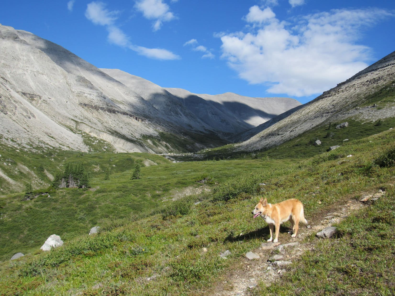
The S ridge became progressively more rocky. The low vegetation began to disappear. Looper came to various rock formations. Sometimes there was a bit of scrambling involved, but nothing significant, scary or long. The trail became less obvious, and began to fade away. Sometimes Lupe followed cairns, though the general direction the route had to take was never in doubt.
SPHP paused frequently to catch breath. The views were incredible! The higher Lupe went, the more spectacular they became.


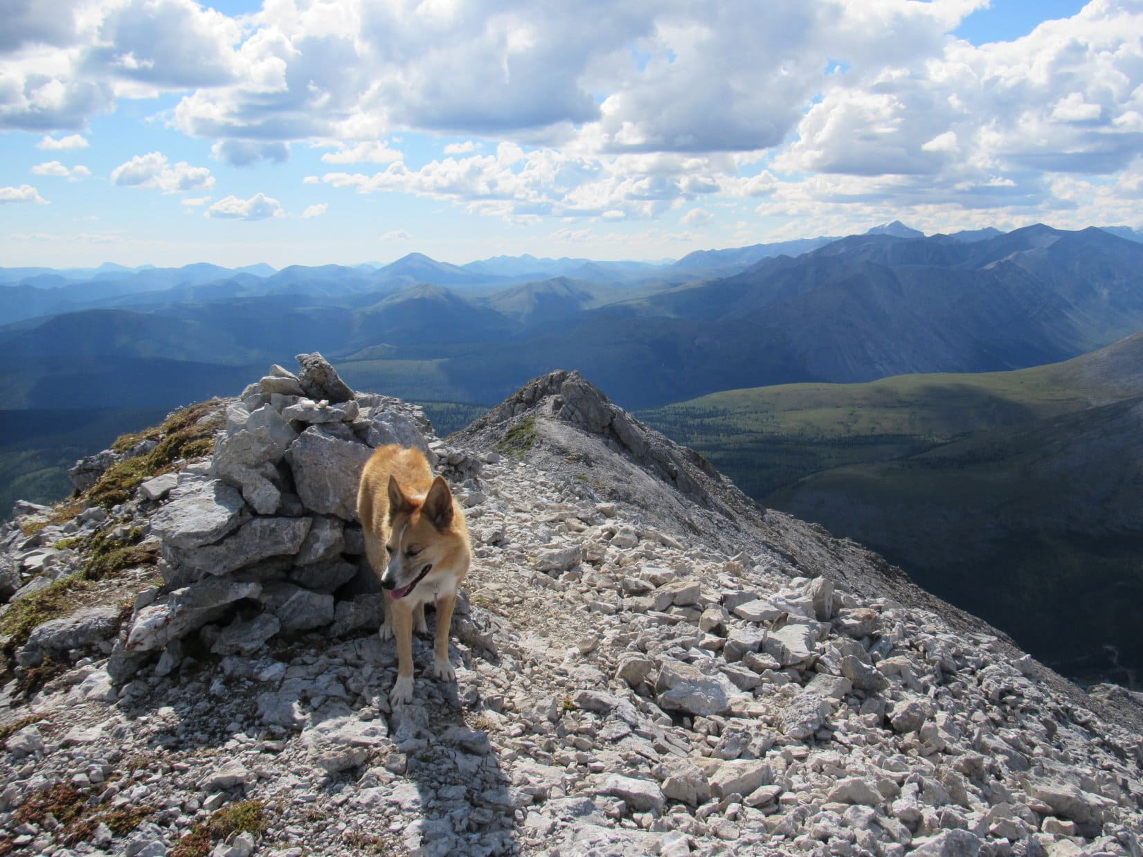
After a long climb, Lupe finally reached the upper end of the S ridge. She was now at the far SE end of Summit Peak’s long summit ridge. This was already a glorious viewpoint, but a somewhat higher point was in view not too far off to the NW. That was the false summit, High Point 6,500 (1981 m), which corresponded to the first star on the trail map that was posted back at the trailhead. The mountain’s true summit could be seen beyond High Point 6,500, still some distance away.


After a pause to take in the views, Lupe and SPHP continued on to High Point 6,500 (1,981 m). Getting there was cake. Lupe stood by a cairn at the top, which she had seen from a distance. This was the location of the first star on the trail map, and the place where most hikers supposedly turn around according to the information back at the trailhead.

All the hard work was done! The weather was perfect. No way on earth were Lupe and SPHP going to turn around here! The American Dingo headed for the true summit.

The stroll along the ridge leading to the summit was pure joy. So easy, such stupendous beauty on all sides, conditions absolutely perfect, and the happy realization that no obstacle was going to prevent Lupe from attaining her peakbagging success!
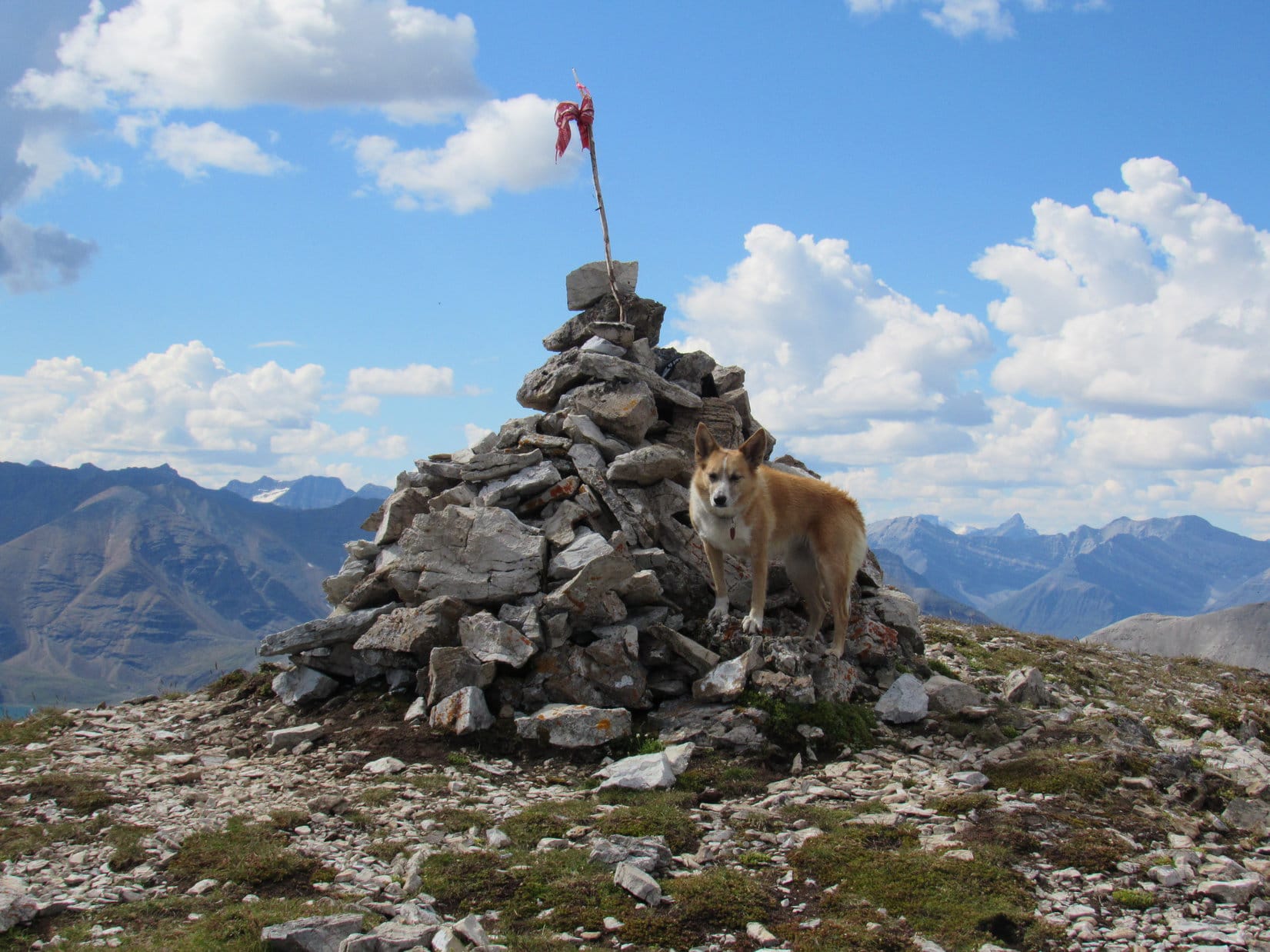
Loopster reached the summit cairn to claim her first Stone Mountain Provincial Park summit.


Getting to the top of Summit Peak had been quite a trek. Lupe and SPHP took a lengthy break at the summit.
There was so much to look at and admire from up here! Many fabulous mountains of the Muskwa Range were in view. Some of the highest, most dramatic peaks were on the far W or SW horizon, sporting big snowfields and glaciers. SPHP had no idea what the names of those mountains might be. They were simply beautiful, remote, and mysterious.
There was no lack of wonderful sights close by, either.


After 45 minutes on Summit Peak, it was time to think about starting for Mount Saint Paul. Lupe and SPHP were about to leave when Lupe spotted movement. People were coming! They would arrive momentarily. Lupe and SPHP waited, and met Dave & Nancy Leckschas.
The Leckschas were from the Okanagan region. They were on a 2 month vacation, with plans to go up the Dempster highway. Dave said he had climbed Mount Saint George once, some 31 years ago. Summit Peak now seemed more difficult than that had been. Encouraging news, since Lupe and SPHP were hoping to climb Mount Saint George tomorrow!

When SPHP mentioned that Lupe intended to go on to Mount Saint Paul from here, Dave said there were already two people up there. Dave lent SPHP his field glasses, and sure enough, two people could be seen very close to Mount Saint Paul’s summit.
After a nice chat with Dave and Nancy, Lupe and SPHP headed out, leaving the Leckschas to enjoy the solitude they had no doubt expected to find on Summit Peak.
Referring to the rest of the route to Mount Saint Paul from Summit Peak, although not in a very clear manner, the information at the trailhead had said “After this viewpoint there are no more rock cairns or a visible trail but the peak can be reached by continuing on along the ridge of the mountain.”
Well, maybe, but that’s not exactly how SPHP would have worded it. Looking toward Mount Saint Paul (6,985 ft.) Lupe could see the ridge the sign was referring to alright. There was one teensy detail that had been left out. Continuing on along the ridge meant dropping more than 1,000 feet (330 m) down an extraordinarily steep rocky slope to a saddle leading to the next part of the ridge.

At first, “continuing on along the ridge” going NW from Summit Peak looked like such a challenge that SPHP hesitated. This route was way steeper than anything the Carolina Dog had faced on the way up. However, there was no doubt this had to be the way. If others had done it, Lupe could too. Lupe started down.

For a while, Dave and Nancy could be seen waving encouragement from up on Summit Peak as SPHP slowly, cautiously trudged down the steep slope. It was soon evident this was actually going to work, although SPHP was clearly destined to chew up a bunch of time on the descent. Finally the terrain began to level out. Lupe reached the saddle leading to the next part of the ridge.

The weather was suddenly starting to become questionable. Each cloud was now sprinkling rain as it sailed by. While Lupe traversed the saddle, the rain showers intensified. SPHP grudgingly called a halt to dig the plastic rain poncho out of the pack.
Putting on the rain poncho worked wonders. Within 10 or 15 minutes the rain showers were kaput. Nada. No more the rest of the day. No doubt failing to have put on the rain poncho would have caused a cloudburst. Life can be like that. Anyway, the rain poncho had done its job. Back in the pack it went. Lupe and SPHP began the process of regaining the 1,000 feet the American Dingo had just lost, and started up the next steep ridge.


At first, the climb up onto the ridge beyond the saddle was steeper and more challenging than anything on the way up Summit Peak had been. Part of the way, SPHP found some use of hands advisable, even necessary. Lupe regained a lot of elevation before the situation improved.
The ridge beyond the saddle didn’t become an easy trek until Loop was back up even with Summit Peak again. She was still gaining elevation from here, though, because this ridge went higher than Summit Peak.


A second saddle existed along this ridge leading to Mount Saint Paul. Even if Lupe followed the very top of the ridgeline the entire way, she wouldn’t lose nearly so much elevation going down to this second saddle from the next high point as she had on that first enormous drop from Summit Peak. However, there didn’t seem to be any reason to gain more elevation than necessary only to lose and regain it again.
Lupe climbed far enough to get a little higher than the second saddle, which she could see ahead. Here a faint, nearly level animal trail went directly across the slope S of the ridgeline straight to the saddle. Following this trail allowed Loop to skip the next high point she’d been approaching on the ridge.
Once Lupe reached the second saddle, only the final steep climb to the summit of Mount Saint Paul remained.


The final climb to the summit of Mount Saint Paul from the second saddle was steep enough so it wasn’t entirely clear if Lupe and SPHP would even make it to the top. At last that happy moment arrived when Lupe popped up onto the summit plateau. The Carolina Dog had made it! SPHP was ecstatic!
An easy stroll brought Lupe to a cairn along the W edge of the summit plateau. This was it, the summit of Mount Saint Paul (6,985 ft.)!


Reaching the summit of Mount Saint Paul was cause for celebration! And a break, a fantastic hour long break. Lupe relaxed by the summit cairn. She had water and Taste of the Wild. She toured all around the whole roomy summit plateau, which was highest toward the NW, but relatively level overall.
And of course, Lupe and SPHP gazed long upon the splendid glories of the Muskwa Range on display in every direction of the compass in Stone Mountain Provincial Park way up here in NE British Columbia.


Lupe’s beautiful, joyous hour on Mount Saint Paul passed by. It was a long way back to the G6. Best get a move on. Looper wasn’t going to return using the same route she had come up. It was late afternoon now, and she didn’t have time to go all the way back to Summit Peak.
Back on Summit Peak, Dave Leckschas and SPHP had commented that Mount Saint Paul’s SE ridge looked like it ought to serve as a good shortcut back and a reasonably easy route down. Now looking down on it from above, it didn’t look quite so amenable. Most of the SE ridge was fine. Getting down to the easy part was the problem. The upper end of the ridge near the top of the mountain was steeper and more challenging than SPHP expected.


Lupe and SPHP started down Mount Saint Paul’s SE ridge. The upper ridgeline was pretty ragged with drop offs that had to be negotiated around. Lupe always stayed on the less steep R (SW) side of the ridgeline when she couldn’t make progress right on it.
SPHP is always terribly, terribly slow on steep rocky descents like this. After a while, SPHP became discontent with the rate of descent. Everything was fine, Lupe would have gotten there, but it seemed like it was taking forever to reach the lower, easier part of the ridge. SPHP got the numbskull idea that things looked easier off to the SW away from the ridgeline.
They weren’t! Soon Lupe found herself far from the ridgeline heading down a slope so steep and rocky that even the Carolina Dog was becoming alarmed. Lupe begged SPHP to stop. She wanted to be held, petted, comforted, reassured. SPHP periodically obliged her, but never for long. It was imperative to get down to the easier terrain far below.
Zigzagging ever so cautiously down the slope trying to avoid drop offs at a series of horizontal rock bands was incredibly slow, and Lupe had to go a lot farther down this way to reach more reasonable terrain than she would have staying on the ridge. The American Dingo made it, though. Anxious to be out of the rocks, she sped ahead long before SPHP was able to move freely.
Deep in the shadow of the mountain, SPHP finally reached the floor of the upper valley. How long had that descent taken? It seemed like hours. Crazy! Pathetic! Nerve-wracking! Thankfully, it was all over now. To SPHP, the trek ahead down the huge valley was just a relaxing end to the long day of peakbagging. To Lupe it was the best part of the whole journey.
Lupe ran and ran, far from SPHP, wherever she pleased. She sniffed, played, explored. SPHP had to keep an eye on that fleet brown and white speck dashing across the countryside, to make sure it never disappeared from sight for very long. Loop periodically returned, grinning ear to ear, panting hard.
It was still a long way back. Lower down, Lupe came to hillsides full of bushes nearly as high as SPHP. Pushing through them threatened to become a difficult, hopefully not impossible, task. The sun was down, and the long twilight of the N country was slowly fading when finally a deep ravine appeared ahead. A creek was at the bottom. Lupe scouted the edge of the ravine until she found a way down to cross the creek.
A 75 foot descent and subsequent higher ascent up a steep embankment on the other side of the creek brought Lupe to a much anticipated link to civilization. The trail! Yes it was here! Lupe was at the base of Summit Peak’s S ridge. No worries now. Puppy ho! Onward! Back to the G6. What a fabulous day! (9:50 PM)

Related Links:
Mount Saint George, Stone Mountain Provincial Park, British Columbia, Canada (8-5-17)
Stone Mountain Provincial Park, British Columbia, Canada
Want more Lupe adventures? Choose from Lupe’s 2017 Dingo Vacation to the Yukon & Alaska Adventure Index, Dingo Vacations Adventure Index or Master Adventure Index. Or subscribe free to new Lupe adventures.