Caribou Mountain, Alaska (8-16-17)

Day 17 of Lupe’s 2017 Dingo Vacation to the Yukon & Alaska!

4:20 AM – Light rain.  The sky showed no improvement.  Lupe wanted out.  SPHP let her go.  She sniffed around in the ditch next to the Dalton Highway on Finger Mountain (2,202 ft.).  It was still dark out, but not completely.  The first faint hint of dawn made it possible to see Loop dimly as she trotted this way and that conducting her investigations.

Suddenly there was movement in the air!  A large bird swooped out of the night to hover directly over Lupe, perhaps 15 or 20 feet above her.  The bird hovered only a few seconds before flying off, but returned a moment later.  It appeared to be some kind of an owl.  An owl intent on Dingo for breakfast!

Lupe took no notice of the owl swooping and hovering above her.  The owl made 7 or 8 different passes before wisely flying off into the gloom, no doubt deeply disappointed that the American Dingo hadn’t been half as big.  Apparently a 30+ pound Dingo was beyond its capabilities.

The Carolina Dog returned to the G6 completely oblivious to the fact that her first and last red eye flight over Finger Mountain’s tundra had been fortuitously cancelled.  Loop curled up and went back to sleep.

7:52 AM – Oh, joy!  SPHP woke to find the rain had ended.  Half the sky was blue!  It was going to be a great day.  Lupe was going to get to climb Caribou Mountain (3,179 ft.) after all!

Before heading for Caribou Mountain, though, Loopster ought to climb Finger Mountain again.  The summit was only 100 yards from the Dalton Highway.  Lupe had been up there yesterday afternoon, but conditions were much better now.  A second journey up Finger Mountain would take hardly any time at all.

In only a few minutes, the Carolina Dog was standing on the summit rocks once again.

On the way to the summit of Finger Mountain. Blue sky had been hard to come by in recent days. It was exciting to see it again! Photo looks NNE.
Lupe back on the highest rock on Finger Mountain. She’d been here yesterday afternoon and in August, 2016, too!
Although half the sky was blue, SPHP soon realized there was fog around, too, some of which can be seen in the background beyond where Lupe is poised dramatically atop Finger Mountain. Photo looks SSW.
Loopster did need a boost from SPHP to get up there. From the other side, it’s not as difficult as it looks from here. Photo looks SSW.
Owls? What owls? I don’t see any owls. Why would I want to keep an eye out for big owls up here? You aren’t making a lick of sense, SPHP!

Back at the G6, SPHP needed to get a few things ready before Lupe left Finger Mountain to look for a place from which to begin her ascent of Caribou Mountain.  After hearing SPHP’s tale about a giant owl that had been ready to swoop down and carry her off into the night to be devoured, Loop decided she would wait inside the G6.

Lupe rests in the G6 while waiting for SPHP to get ready for Caribou Mountain. She pondered the crazy, scary tale SPHP told her about an owl swooping down out of the night sky wanting to devour her. What is an owl, anyway? How big are they really? Are we talking chickadees or pterodactyls here?

Caribou Mountain is only 7 miles WNW of Finger Mountain.  Lupe was going to head a few miles N on the Dalton Highway to see if she could find a place to start closer to it, but the mountain was already in view.  Did Loop want to have a look at Caribou Mountain from Finger Mountain before heading out?

Yes, she did!  No owl would dare swoop down on a fully grown ferocious American Dingo in broad daylight!  If it did, it would be that owl’s last swoop ever.  We’d see just who would devour who.  SPHP was full of it.  Maybe it was August Fool’s Day or something?

Lupe crossed over to the W side of the Dalton Highway.  She climbed up on the same rock formation she had visited yesterday over here.  Sure enough, there was Caribou Mountain (3,179 ft.) off to the WNW.  It looked easy!  Just a miles long, gentle ridge.  Why, Lupe would have a blast up there!  Running around exploring open tundra was one of her favorite things.

Caribou Mountain (R in the distance) from Finger Mountain. Photo looks WNW.
Loop on the Dalton Highway near the G6 before leaving for Caribou Mountain. The summit of Finger Mountain is the knob of rock on the R. Photo looks NE.

After taking a gander at Caribou Mountain from Finger Mountain, Lupe and SPHP took off in the G6 heading N on the Dalton Highway.  The idea was to find a place along the highway where the G6 could be stashed somewhere close to the end of Caribou Mountain’s miles long NE ridge.

SPHP was surprised to see buildings W of the Dalton Highway where the best place to start an ascent of Caribou Mountain seemed to be.  There was no sign of anyone around.  The place looked like an abandoned homestead, but maybe not, too.  The buildings didn’t look old enough to be certain.

Buildings way out here?  A lone house 15 miles from the Arctic Circle?  Was this area private property?  SPHP had no clue.  It seemed unlikely to say the least.  Hmm.  SPHP drove on to see what other possibilities might exist.

After driving back and forth over the same few miles several times, SPHP finally parked the G6 along the edge of a wide gravel road 30 feet from where it left the W side of the Dalton Highway.  Lupe was a little farther N than SPHP would have liked, about a mile S of the Kanuti River, but the chances of an angry landowner suddenly appearing here seemed remote.

The short road was blocked by a large red metal gate.  This road was a link to the Alaska oil pipeline service road only a short distance from the highway.  The G6 was parked leaving plenty of room so service vehicles needing to get by could easily do so.

When Lupe set out (9:39 AM, 50°F), the summit of Caribou Mountain (3,179 ft.) was about 4 miles away as the crow or evil owl flies, perhaps 5 following the NE ridge.  A line of trees blocked views of the ridge from the G6.  Loop and SPHP went around the red gate, which was chained shut, and followed the gravel road.  A short stroll brought Lupe beyond the stand of trees.

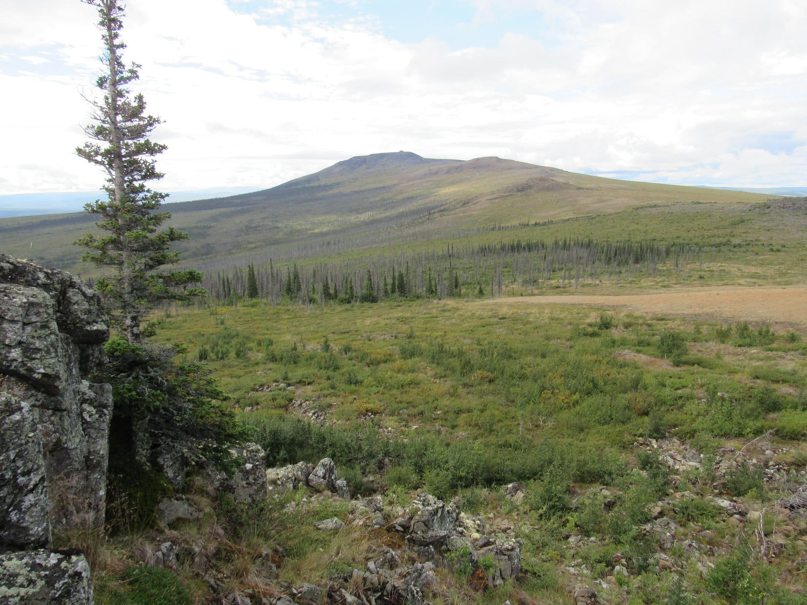
Ahead was a mixed deciduous forest of small trees and tall bushes.  Beyond the forest was a big hill, part of a rounded ridge leading higher and farther S.  A conifer forest was present on lower portions of the big hill, but the upper slopes looked like a mostly barren region of alpine tundra.

Lupe’s first mission was clear.  She needed to get beyond the forests and bushes.  If the Carolina Dog could reach the alpine tundra, she should have an easy obstacle-free climb the rest of the way up the big hill.  From there she could proceed to the ridge beyond it.

Only a few minutes after leaving the G6 and bypassing the red metal gate, Lupe came to this view of a big hill she would need to climb. Beyond the hill, she could continue up Caribou Mountain’s NE ridge. Photo looks SSW.

Loop followed the road as far as it went toward the big hill, which wasn’t far at all.  Directly ahead was an area that looked like flat, easy terrain.  However, it proved to be full of tussocks and boggy.  A tremendously thick layer of spongy vegetation gave way at each step.

It soon became clear that Lupe was heading for a pond.  There seemed to be somewhat higher ground on the N side of the pond, which proved to be true.  The ground here was much firmer and drier.  Lupe managed to circle around the N and W sides of the pond without further difficulties.

Lupe on drier ground along the N side of the pond. The pond had a small island (Center) in it. The hill Lupe is headed for is on the R. Photo looks S.
Looking back at the pond after getting past it. Photo looks NE.

Once around the pond, Lupe was almost immediately confronted with an area dominated by a dense tangle of bushes higher than SPHP’s head.  The terrain was beginning to rise here, but was rough and uneven.  Low spots were filled with water, in some places several feet deep.

This region was a real jungle for Lupe.  Even SPHP couldn’t see a thing.  At least Looper could maneuver through it reasonably well, but for SPHP it was a tough slog trying to force a way through.  Fortunately the dense jungle trek wasn’t terribly long.  The Carolina Dog eventually stumbled upon a little hill about 10 feet high.  Beyond it was a more open slope of scattered conifers and bushes.

Loop down in the jungle wondering why SPHP had led her to this place?
Beyond the jungle of bushes, Lupe came to more open ground where scattered pines and bushes were plentiful. These bushes were not nearly so large as those comprising the jungle had been. Photo looks SW.

The terrain was now rising at a steady clip.  It wasn’t steep, but going up the long slope was harder than anticipated.  The scattered forest was surprisingly wet and boggy.  Small pools of water, often connected by little streams, were all over the place.  Tussocks were present, making footing unreliable.  Deadfall timber was scattered about, but wasn’t too much of a problem since the trees here were stunted.  A fair number of dead trees were still standing.

Lupe and SPHP forged ahead, trying to aim for whatever seemed to be the driest part of the slope.  Gradually the trees and bushes thinned out and disappeared.  The pools of water and little streams faded away, too.  Lupe had made it to the mostly barren upper slopes of the big hill.  Underpaw were small rocks and sparse tundra vegetation.

Lupe reaches the barren upper slopes of the hill she’s been climbing. The trees, bushes and wet terrain have all been left behind down below. The pond Lupe had passed by is now seen beyond Lupe way down at the base of the hill. The Dalton Highway is in view, too. Photo looks NNE.

The climb was steeper up here, but the terrain was great.  No obstacles at all!  Somewhere along the way, Lupe reached the top of the big hill she’d been aiming for, but it was hard to say exactly where.  It was all part of a broad, rounded ridge continuing higher.  The American Dingo just kept climbing.

On the way up to Caribou Mountain’s main NE ridgeline. Steeper here than down below, but this was obstacle-free terrain far easier than what Lupe had dealt with earlier. Photo looks SW.
Getting closer to the main ridgeline. Things are starting to level out quite a bit. If SPHP had been able to park the G6 farther S where originally planned, Lupe would have been coming up the ridge seen in the distance on the L. Photo looks SE.

Lupe reached Caribou Mountain’s main NE ridgeline at a particularly barren point.  Hardly any vegetation was present here.  Small reddish rocks covered the ground.  The area was quite flat, having only a slightly rounded aspect to it.  A couple hundred yards ahead was a cluster of rocks perhaps 25 or 30 feet high.  To the SE was a bigger hill along the ridgeline, High Point 2355 on the topo map.

If SPHP had been able to park the G6 farther S as originally intended, Lupe would have arrived here from the direction of High Point 2355.  As it was, the Carolina Dog had effectively bypassed it.

Lupe reaches Caribou Mountain’s main NE ridgeline. Ahead on the R is a cluster of rocks she would go explore. On the L is High Point 2355. Photo looks S.
Olsons Lake is one of the large ponds in the distance beyond Lupe. Photo looks E.

For the first time, the summit of Caribou Mountain was now in view, about 3 miles to the SW.  Lupe could see much of the very wide, gently rounded NE ridge leading to it.  A number of high points were visible along the way.

The summit of Caribou Mountain is on the L. A huge part of Caribou Mountain’s NE ridge is in view here. After exploring the cluster of rocks nearby (not pictured off the L edge), Loop would next continue on to the closest, but lower, high point seen in shadow on the R. Photo looks SW.

Before continuing on toward the summit, Lupe went to check out the nearby cluster of rocks.  She climbed partway up, getting quite close to the top.

Caribou Mountain from the N end of the cluster of rocks. Photo looks SW.
Lupe up on the cluster of rocks. Photo looks NW.
Intrepid Carolina Dog, Lupe, on her way to Caribou Mountain.

After finishing her fun little scramble on the cluster of rocks, all Lupe had to do was keep following Caribou Mountain’s vast NE ridge toward the summit.  The next high point along the way was a small rocky ridge about 15 minutes away off to the W.  Loopster would actually lose a little elevation going over to it.

As Lupe neared this next high point, the terrain changed a bit.  Medium size rocks were strewn around the area near the ridge.  Small trees and bushes grew here.  The ridge itself was 40 or 50 feet high, consisting of rough rock and assorted large boulders.  A short easy rock hopping scramble would get Loop to the top.

Approaching the next high point along Caribou Mountain’s NE ridge. This rocky little ridge would be a quick, easy scramble for the Carolina Dog. Photo looks WNW.
On the highest rocks. High Point 2355 is in the distance R of Center. Photo looks E.
Still on the highest rocks, but looking NE now.

Lupe had approached this small ridge from the E, which turned out to be its highest and most dramatic side.  Beyond the boulders at the top, the ridge was more like a relatively level hilltop.  Medium size rocks and small bushes covered this area.  Several more large boulders were here, too.  Lupe got up on one of the biggest.

Loop up on another big rock. On the L are some of the bushes and medium size rocks that cover the flat hilltop on the W side of this little ridge. In the distance on the L are several high points leading to the summit of Caribou Mountain. Photo looks SW.
The sky was starting to cloud up, but the weather wasn’t an issue yet. The summit of Caribou Mountain is in the distance on the L. Photo looks SW.
I can see for miles from up here in every direction, but still haven’t seen a single owl, SPHP! You sure you didn’t make that scary owl story up? Hey, isn’t this Caribou Mountain? Come to think of it, I haven’t seen any caribou yet, either! What’s up with that?

Continuing on, Lupe scrambled down the W side of the rocky hilltop.  Two much bigger high points were now ahead to the SW.  The summit of Caribou Mountain was in view beyond them.

After a short scramble down off the rocky hill, two much larger high points are ahead. The summit of Caribou Mountain is beyond them in the distance. Photo looks SW.

These next two high points were not collections of medium to large rocks and boulders, like the two high points Looper had just visited.  They were big, rounded hills covered with alpine tundra and mostly smaller rocks.

Loop did not go clear to the top of either of these next two high points.  Expending the extra energy required to do so was unnecessary.  The smooth, steadily rising slope made it easier to simply skirt around the NW side of each hill, although Lupe did pass fairly close to the summits in both cases.

Loop beyond the first of the big hills. She would go around the NW (R) side of the next hill seen on the R, too. Photo looks SW.

Nearing the second of the big hills, Lupe came to another cluster of big rocks and boulders that formed a small prominent point perhaps 20 to 25 feet high.  SPHP was well beyond this prominence, before realizing that the American Dingo was still back there.

Lupe had discovered some sort of squirrel or pika or something similar that apparently made this cluster of rocks its home.  The Carolina Dog was in hot pursuit of the lively squirrel, which was extraordinarily quick and agile.  The squirrel leapt confidently boulder to boulder, circling the cluster of rocks, suddenly appearing as if by magic first one place then another.

The squirrel had the advantage of being able to scramble way up to the top of the spire where Lupe couldn’t possibly reach it.  However, the squirrel didn’t seem to realize it was completely safe up there, and kept darting down among the lower rocks hoping to get out of sight.

For Lupe this was an exhilarating game of chase!  When it came to speed and agility, she was no slouch either.  She bounded around circling the whole rock cluster at such an enthusiastic, single-minded pace, that SPHP feared Loop might break a leg, if this game wasn’t brought to a speedy end.  SPHP had to call her twice before she reluctantly left the squirrel unharmed, still lord and master of its rock cluster.

Lupe returned to SPHP breathless, panting hard, with an enormous grin on her face.  For the next little while, she roamed far and wide searching diligently for another squirrel, but her efforts were disappointed.

Continuing up toward the second big high point (R). Photo looks SW.
Looking back down Caribou Mountain’s NE ridge. The closest high point (L of Center) is the first of the big hills, which Loop is now well above. The small rocky ridge she had been to before that is beyond it on the L. Photo looks NE.
On rocky ground not too far from where the lively squirrel was. Lupe is already beyond that little adventure. The second big hill is dead ahead.
Looper on her way around the second big hill. She’s fairly high on its upper NW slope, standing on one of a series of minor rock outcroppings in this area. Photo looks WNW.
Still along a line of minor rock outcroppings on the way around the second hill’s NW slope. Caribou Mountain’s summit is ahead on the L. Photo looks SSW.

When Lupe made it beyond the second big hill, she found herself in a moderately sloping area.  This region had a fair amount of small to medium size rock, and was surprisingly boggy.  The water supply made the tundra more lush here.  Ahead, a long ridge slanted steadily up from the N toward the NE end of a dark hill.

The summit of Caribou Mountain was somewhere up on that hill.  From a distance, the summit had appeared heavily forested.  By now, though, Lupe could clearly see that it wasn’t.  The hill consisted of exposed dark colored rocks and boulders.

Lupe traipsed through the boggy area, angling WSW toward the ridge slanting up to the NE base of the summit hill.

Beyond the second big hill, Lupe reaches a surprisingly boggy area full of pools and trickling streams. She headed WSW (R) to get up on the ridge sloping up to the base of Caribou Mountain’s summit hill (Center). Photo looks SSW.

The boggy area was more extensive than anticipated.  It took longer than expected to get through it, and make the trek up the ridge.  Eventually, though, Lupe was approaching the hill of dark rock at the top of Caribou Mountain.  It was maybe 125 to 150 feet high, and would be a pretty steep scramble the entire way up.

Loop approaches Caribou Mountain’s big summit hill comprised of dark rocks. A steep scramble up the NE face awaits her. This hill was perhaps 125 to 150 feet high. Photo looks SW.
Looper could have scrambled up the E end of the summit hill. This route would have been longer, but not as steep. Instead of taking this E route, Loop went right up the NE face. Photo looks S.

The scramble up the NE face of the big summit hill was fun and actually quite easy.  It went quickly.  Most of the rocks were stable, and it wasn’t hard to find routes avoiding the biggest boulders and other impassable spots.  Many rocks were covered with bright orange lichens.

Loop pauses to check out the views on the way up the NE face of the big summit hill. She had plenty of time to look around while pokey SPHP tried to keep up.
Bright orange lichens grew on many rocks.

At the end of the scramble, Lupe reached a gently sloping region.  The top of the summit hill was a vast area many acres in size. The ground was covered with scattered patches of alpine tundra.  Between the patches were ditches full of rocks.  Each patch of tundra was sort of like an island, surrounded by these rock-filled ditches.

From a great distance, a little dark knob had been visible up on top of Caribou Mountain.  As it turned out, Lupe had scrambled up quite near it.  She could now see that the dark knob was actually a hill of rock about 75 feet high superimposed upon the vast general summit region she had just reached.  Unless something higher was hidden beyond it, the true summit of Caribou Mountain had to be up on this final rocky hill.

Lupe reaches Caribou Mountain’s general summit region. The 75 foot high hill ahead is the dark knob she had seen from miles away. Photo looks SW.

The N face of the smaller hill was another fun scramble.  Lupe came up right between the two highest rocks.  It was instantly clear Loop had made it to the true summit of Caribou Mountain (3,179 ft.)!

On the highest rock was a survey benchmark.  It even said Caribou.

To SPHP’s surprise, Lupe found this Caribou survey benchmark on the highest rock on Caribou Mountain.
Lupe reaches the true summit of Caribou Mountain. The survey benchmark is next to and slightly behind Loop on the L. Much of the long NE ridge Lupe had followed to get here is seen beyond her in the distance. Photo looks NE.
View to the NW from the true summit. The deep valley beyond the barren light green territory in the foreground is the Kanuti River valley.

After an initial look around, Lupe found a bigger surprise 25 feet SW of the true summit.  Among the rocks was another survey marker.  Next to the marker were two plaques in memory of Jamie & Jason Burroughs.

25 feet SW of the true summit, Lupe discovered another survey marker and two plaques in memory of Jamie & Jason Burroughs.
Were Jamie and Jason siblings? It seemed likely. They were born within a few years of each other. Both died young. Jamie lived only 18 years. Jason passed away 2 days after his 34th birthday.

Stashed among the rocks near the plaques were a clear plastic jar and a thermos with the Big Dipper and North Star on it.  The jar contained only a plastic bag with a pen and two pencils in it.  The thermos was tightly stuffed with two plastic bags containing more pens, registries, and some other papers.

Stashed among the rocks near the commemorative plaques were a clear plastic jar and a thermos with the Big Dipper and North Star on it.

The registries contained so few entries, SPHP read them all.  One entry of particular interest was by Jason Burroughs dated 2008 or 2009.  Jason had written that he had lived at the base of Caribou Mountain for 2 years.  Some of the additional papers revealed that Jason ran a resort – Old Man Alaska Bed & Breakfast.  There was even a photo of Jason and his two daughters.

Nothing indicated how or why either Jason or Jamie had died so young.  Those buildings Lupe had seen this morning on the W side of the Dalton Highway while SPHP had been looking for a place to park the G6 must have been where Jason had lived.  It was probably the former site of Old Man Alaska Bed & Breakfast.  Absolutely nothing else was around here way out in the Alaskan wilderness.

SPHP signed Lupe into the registry, then put everything back in place.  Time to check out the views from Caribou Mountain.

Looking down from the knob where the true summit of Caribou Mountain is located on the much larger general summit area below. The striking pattern of patches of tundra scattered among a network of rock-filled ditches is evident. Photo looks S.
All the major high points Lupe came to along Caribou Mountain’s NE ridge are in view here. Photo looks NE.
Lupe in sunshine on Caribou Mountain. Photo looks NE with help from the telephoto lens.
The pattern made by the tundra and rocks on Caribou Mountain was so cool to look down upon! Photo looks SSW.

The sky had been totally overcast when Lupe arrived at the true summit of Caribou Mountain. Since then, holes had appeared in the clouds once or twice.  Lupe basked briefly in bright sunshine.  However, as time wore on, it was becoming clear the Carolina Dog was leading a charmed existence.  Rain showers could be seen in every direction.

The showers to the N and E were quite a long way off.  The ones to the W were closer, but weren’t headed this way.  The real threat was from the S.  A long line of showers was advancing toward Caribou Mountain, driven by a steady S breeze.

Lupe had arrived early enough in the day so she should have been able to spend a long time at the summit.  Sadly, it wasn’t going to work out that way.

Rain showers are seen off to the W.
Looking W with help from the telephoto lens.
Looking N with help from the telephoto lens.

Lupe and SPHP spent 45 minutes up on the rocky summit of Caribou Mountain.  Then, with rain showers approaching, it was time to get going.  Before departing glorious Caribou Mountain, Lupe returned to the highest rocks at the true summit.

Lupe on Caribou Mountain’s highest rocks. The survey benchmark (near her rear paw) and long NE ridge are both in view. Photo looks NE.
An American Dingo at the true summit of Caribou Mountain. Looking NE with help from the telephoto lens.
Another look with less help from the telephoto lens. Photo looks NE.
A better look at the NE ridge. Lupe has moved slightly. The Caribou survey benchmark is a few feet beyond her at Center. Photo looks NE.
Final look NE from the true summit.

Lupe remained briefly up at the summit while SPHP started down.

Lupe along the N edge of the knob at the top of Caribou Mountain.
Be there in a minute, SPHP. Keep going! I’m a much faster scrambler than you are.

The return trip was a race against deteriorating weather.  Loop followed the same general route back down the NE ridge.  For a long way, the return trip was a great deal of fun.  Lupe never saw the sun again, but the views were so awesome!  The strengthening S breeze and encroaching clouds created a wild, gloomy, menacing mood enhanced by the knowledge that Lupe and SPHP were alone in northern Alaska.

Looking back toward the summit of Caribou Mountain. Lupe is almost back down to the second big hill she’d come to on the way up. Photo looks SW.

On the way back, Lupe tagged the summits of both the big hills she had skirted on the way up.  Between them, a rain shower caught her.  SPHP had stopped to put on the rain poncho only minutes before.  The S wind drove the rain so hard the raindrops stung a little.  This first shower lasted only 10 minutes.  Lupe got wet, but SPHP hadn’t fared too badly.

Looper now between the first and second big hills she’d passed by on the way up. The first rain shower would catch up with her in only a few minutes. She still had miles to go to get to the G6. Photo looks NE.
The first big hill is the closest one on the L. Beyond it at far L is the little rock ridge. High Point 2355 is near Center. The cluster of rocks Loop came to first on the way up is the little dark knob to the L of High Point 2355. Photo looks NE.
On a scenic knob along the way to the first big hill. Photo looks NE.
Little tundra plants can be so incredibly colorful and beautiful!

Lupe was doing great!  She was making excellent progress.  Rain was all around, but except for that one 10 minute shower, the Carolina Dog was lucky.  She made it all the way back to the area where she had first reached the main NE ridgeline.  SPHP wasn’t eager to go back down the boggy lower slope Lupe had originally come up to get here, however.  It would be nice to avoid that jungle of bushes down near the bottom, too.

Lupe makes it back to the area where she’d originally reached Caribou Mountain’s main NE ridgeline. Photo looks SW back toward the summit.
The original route Loop had taken up to reach the main NE ridgeline is below on the R. SPHP wasn’t eager to repeat a long boggy trek down the lower slope and through the jungle of bushes waiting at the bottom. The Dalton Highway is finally back in sight here. Photo looks NNE.

Instead of taking the same route down that she had come up in the morning, Lupe stuck with the main NE ridge longer.  This time she passed only a little N of High Point 2355.  The Carolina Dog went to the far E end of Caribou Mountain’s NE ridge before turning N.

Turning N near the far E end of Caribou Mountain’s long NE ridge. The Dalton Highway crosses the Kanuti River in the distance on the R. Photo looks NNW.
Lupe needed only another half hour to get back to the Dalton Highway and the G6 from here, but her luck was about to run out. Photo looks E.

The G6 was only half an hour away when Lupe’s luck ran out.  A second rain shower finally caught her.  This time it was no mere 10 minute affair.  Rain poured down twice as long and twice as hard as the first time.

Lupe had avoided the boggy terrain and the jungle of bushes, but it hardly mattered.  Coming down off the ridge, she had to go through a forest with deadfall, meadows of high grass, and stands of tall bushes.  Everything was soaking wet.  By the time Loop and SPHP reached the service road along the buried Alaska oil pipeline, both were drenched.  May as well have gone swimming!  (7:30 PM)

No matter.  The G6 wasn’t far away now.  SPHP would make everything alright there.  The important thing was Lupe had made it to the top of Caribou Mountain today.

Lupe returning from Caribou Mountain, Alaska 8-16-17

Want more Lupe adventures?  Choose from Lupe’s 2017 Dingo Vacation to the Yukon & Alaska Adventure IndexDingo Vacations Adventure Index or Master Adventure Index.  Or subscribe free to new Lupe adventures.

Finger Mountain on the Dalton Highway, Alaska (8-15-17)

Days 15 & 16 of Lupe’s 2017 Dingo Vacation to the Yukon & Alaska!

Day 15, 8-14-17 – Windy!  Waves were crashing into the shore of Kluane Lake when Lupe wanted out in the wee hours of the night.  She was soon back, and apparently famished.  Another generous helping of Alpo, and the Carolina Dog was ready to curl up under her blankie again, still worn out from her big climb up Sheep Mountain (6,400 ft) yesterday.

Hours later, Lupe had chocolate sugar wafer cookies for breakfast as SPHP drove N on the Alaska Highway.  The cookies were a big hit!  In the rear view mirrors, Mount Decoeli (7,650 ft.) could be seen in clear skies far to the S.  Up ahead, though, the sky was cloudy and dark.

The plan for the day was to climb a mountain Lupe had seen near the Donjek River last year.  The mountain ought to have a fabulous view of a long stretch of the braided river, and snowy mountains of the St. Elias Range to the SW as well.  Of course, it all depended on the weather, and SPHP was soon driving through rain showers.

The rain eventually ended.  The sky cleared somewhat.  A mountain came into view that looked like it might be the one Lupe hoped to climb.  Although most of the sky was still cloudy, the mountain was bathed in sunshine.  The upper slopes sported an unexpected dusting of new snow.

A mountain bathed in sunshine and sporting a dusting of new snow on its upper reaches came into view. At first, SPHP thought this was the mountain near the Donjek River that Lupe intended to climb. Turned out it wasn’t. Photo looks N.

The brightly lit mountain turned out not to be the one Lupe intended to climb.  The Donjek River was still farther away than SPHP thought.  By the time Loop was getting close to the river, she was beyond the sunny mountain and seeing wonderful white peaks off to the SW.  One of these peaks, situated on the distant horizon, was a monstrous white spire that dominated everything else.

After crossing the bridge over the Donjek River, SPHP found a place to park the G6.  Lupe got out for a look around.  An easy stroll brought her to a bank overlooking the river.  Beyond the meandering stream, Looper could see the closest of the white mountains.  They gleamed white and gray beneath a mix of soft clouds and pale blue sky.

Lupe arrives at the Donjek River where the Alaska Highway crosses it. To the SW, she could see white peaks in sunshine beneath a mix of pale blue sky and clouds. Photo looks SW.
The forested territory between the Donjek River and these white peaks may be part of the Wolverine Plateau, but SPHP isn’t entirely certain about that. Photo looks SW.
These amazing white peaks are only the start of genuine mountaineering territory in the heart of the mighty St. Elias Range beyond them. Photo looks SW with lots of help from the telephoto lens.

Even higher peaks were seen more to the S, some completely covered with snow.  They made a gorgeous backdrop for the Donjek River.

A couple of entirely white peaks soar above the front range beyond the Donjek River. Photo looks S.

Unfortunately, all the blue sky was way over by the white and gray mountains to the SW.  Apparently, only that one big hole existed in the general layer of cloud cover seen over the rest of the sky.  SPHP still thought the mountain next to the Alaska Highway that Lupe had come to climb looked possible, but the summit was hidden by fog.  Hmm.

On a clear day, the views of the Donjek River and St. Elias Range from up there would be amazing!  No telling what the Carolina Dog might see!  SPHP pondered whether it was worth making an attempt.  Conditions were marginal, if Loop really expected to see much.  No point in taking on trackless wilderness and more than 3,400 feet of elevation gain, if she wouldn’t.  In the end, it seemed like the wrong move.  The mountain near the Donjek River really ought to be saved for a day with brilliant sunshine.

Loop and SPHP continued N.  The American Dingo’s next stop came after crossing the White River.  The White is even bigger than the Donjek.  In fact, the Donjek River becomes a tributary of the White River somewhat farther downstream.

Lupe stops for a look at the White River, a giant braided stream even larger than the Donjek. Photo looks NE.
The White River has a super wide flood plain as it flows N out of the mountains. The SE end of Horsecamp Hill (4,600 ft.) is seen on the L. Horsecamp Hill was another peakbagging possibility that got scratched today. Photo looks NE.

N of the White River was Horsecamp Hill (4,600 ft.), another mountain on Lupe’s list of possible peakbagging objectives.  However, the shortest approaches from the SW off the Alaska Highway looked very steep, and the whole mountain appeared heavily forested.  Even if Lupe made it to the top, she might not get any bird’s eye views of the White River, the whole point of even considering an ascent.  The weather was no better here than it had been at the Donjek River, either.  With so many strikes against it, Horsecamp Hill was out.  Oh, well!  Onward!

Gray skies and occasional light rain showers extended mile after mile.  No blue sky anywhere.  Lupe alternately snoozed atop her pile of pillows and blankets, or stared out the window searching in vain for wildlife.  She left Canada entering Alaska again.  The bridge over the Tanana River came 12 miles before Tok.  It wasn’t raining here, and there was a rest area.  Time to get out and sniff the air for a few minutes.

Lupe takes a break from the G6 near the Alaska Highway bridge over the Tanana River. Photo looks SE.

Though she traveled hundreds of miles, Lupe failed to find even a speck of blue sky the rest of the day.  NW of Tok, the sky was heavily overcast.  Loopster may not have gotten a workout, but the windshield wipers did.  It rained frequently.  It wasn’t raining when the Carolina Dog pulled into Fairbanks at 5:45 PM, but looked like it could again at any moment.

Loop would spend the night in Fairbanks.  Hopefully morning would bring better news.

Day 16, 8-15-17 – The only thing that was clear, was that not much had changed overnight.  No rain at the moment, but the pavement was wet.  Dark clouds still ruled the sky.

SPHP bought supplies and fuel for the G6.  Eventually there was good news.  Patches of blue sky had appeared, and were growing in the W.  It was enough.  Lupe and SPHP left Fairbanks.

On the drive to Livengood, the Elliot Highway was wet the entire way.  Every time the road turned E or N, the weather deteriorated.  Every time it turned W, conditions improved.  SPHP sometimes drove into fog high on forested ridges, but always drove out of it again in the valleys below.  A little past Livengood, Lupe reached the start of the Dalton Highway.

Lupe reaches the start of the Dalton Highway. The Dalton Highway goes 414 miles N to the Arctic Ocean, officially ending only a few miles short of Prudhoe Bay.

The first 40 miles or so on the Dalton Highway were all dirt and gravel.  Today the road was a complete sloppy, muddy mess.  SPHP drove slowly.  The G6 became filthy, but kept going.  Current weather conditions were gradually improving.  Sunshine peeked through gaps in the clouds.  Bits and pieces of blue sky managed to reach the highway.

A 12 mile stretch of pavement led to a few more miles of dirt and gravel before Loopster reached the bridge over the Yukon River at milepost 56.  After crossing the bridge, she stopped for a look at the mighty Yukon.

Looking NE down the Dalton Highway bridge over the Yukon River. The Alaska oil pipeline crosses the river attached to the underside of this same bridge, and can be seen snaking away from the far end.
Lupe has a look at the Yukon River. There is a small visitor center on the N side of the river E of the Dalton Highway. Fuel is available on the W side of the highway, but it ain’t cheap at $5.50 per gallon. SPHP didn’t buy any. Don’t quibble, though, if you’re getting low! The next gas station is at Coldfoot camp 119 miles farther N.
Lupe on the N bank of the mighty Yukon River. She had been here in 2016, too. It was sort of amazing, almost hard to believe, that she had made it all the way back here again! Photo looks WNW.

In addition to visiting the Yukon River, Lupe went to see the Alaska oil pipeline.  Although sometimes miles from the Dalton Highway, the oil pipeline roughly parallels the highway all the way to the Arctic Ocean, and is often in view.

Lupe visits the Alaska oil pipeline during her stop at the Yukon River. In 2016, Lupe learned it could be lots of fun exploring sections of the service road that follows the pipeline. Much of her gorgeous last mile N trek in the Brooks Range in 2016 had been along the pipeline service road. Photo looks NE.
This map showing highlights along the Dalton Highway was on display near the Yukon River visitor center.

N of the Yukon River, the Dalton Highway was dirt and gravel, which meant mud.  SPHP was concerned about the first few miles.  In 2016, when the weather had been sunny and much drier, there had been a mile or two of very soft highway in this area.  The G6 had threatened to bog down even then.  The road might easily be impassable now.

Not to worry.  The road was much improved over the past year.  Despite the mud, the G6 sailed through much more confidently than a year ago.  Loop wasn’t going to be forced to retreat S.  Finger Mountain (2,202 ft.), today’s destination, was only 42 miles N of the Yukon River.  Loopster was going to get there!

On the way to Finger Mountain, the weather deteriorated again.  SPHP drove through intermittent rain showers.  Only tiny patches of blue sky remained.  A couple miles before reaching Finger Mountain, the Dalton Highway turned from mud to good pavement.  That was a relief!

A rain shower was in progress when Lupe made it to Finger Mountain sometime after 3:00 PM.  A strong wind blew out of the W.  Low, ragged clouds raced by at a tremendous pace.  Off to the NW, the summit of Caribou Mountain (3,179 ft.) was hidden from view.  The S side of the Brooks Range, which ought to have been in sight, wasn’t.

Finger Mountain is only a big, rounded, gentle hill.  The Dalton Highway goes right over it around milepost 98.  A few stunted trees exist, but most of the mountain is covered with low bushes and small plants typical of alpine tundra.  E of the highway, a granite rock outcropping juts some 20 or 30 feet above the surrounding terrain.  This rock outcropping is the true summit of Finger Mountain.

Lupe had climbed Finger Mountain only a little over a year ago.  For the American Dingo, it was a quick, easy peakbagging success.  On a clear day, the views had been wonderful, too.  Loopster had every intention of repeating this exploit.  When the rain quit and wind slackened around 4:30 PM, both Lupe and SPHP left the G6 heading directly for the summit.

A short stroll, a tiny scramble, a boost from SPHP, and Lupe was there.  For the second time in her life, Lupe stood at the tippy top of Finger Mountain (2,202 ft.)!

Lupe needed a boost from SPHP to get to the top of Finger Mountain. After an absence of a little more than a year, the Carolina Dog was back!
Lupe remains perched atop Finger Mountain while SPHP scrambles down for a more distant shot. Photo looks N.
Kind of windy up here, SPHP! Can I come down yet? …. No, stay where you are Looper, gimme a couple more minutes!
The granite formation at the summit of Finger Mountain looks the most impressive from this direction. Pretty much the entire elevation gain coming from the Dalton Highway only 100+ yards away is on display here. Photo looks N.
Oh, looks good, Looper! You could be at the top of some towering massive peak the way this photo turned out. You can come on down now, if you like.

With clouds obscuring some of the best views, Lupe was ready to get down out of the annoying breeze as soon as SPHP said she could.  She leapt down all on her own.

A short nature trail circles the hillside immediately NE of Finger Mountain’s summit.  For fun, Loop and SPHP took a leisurely stroll around the loop.  Lupe wound up right back at the base of the summit rocks.  This time she didn’t bother going to the top.

Lupe stands below the summit rock she had been up on top of earlier. Photo looks SSW.

With all the clouds around, the views from Finger Mountain weren’t nearly what they might have been.  Lupe was going to spend the night here.  Maybe they’d be better in the morning?

After having spent most of today and yesterday cooped up, Lupe wasn’t ready yet to retreat to the G6 again.  Fortunately, there were a couple more things to do on Finger Mountain.

Another granite formation, not as large or high as the one at the summit, was right across the Dalton Highway on the W side of the road.  With plenty of time left in the day, and not a whole lot to do with it, Lupe was all for sniffing around and exploring that rock formation, too.

The smaller granite formation on the W side of the Dalton Highway.
On a clear day, Lupe would have had a great view of Caribou Mountain (3,179 ft.) from here. The summit is in the distance on the L, currently hidden by clouds. Photo looks WNW.
Olsons Lake is one of the large ponds near Center. The Dalton Highway winds off into the distance. The Alaska oil pipeline is buried underground here where the strip of bare land is seen on the L. Photo looks NNW.

Finger Mountain is named after a famous tor, Finger Rock, located roughly 0.25 to 0.50 mile SSE of the true summit where Lupe had just been.  Finger Rock is said to point in the general direction of Fairbanks.  Bush pilots have been rumored to use it as a navigation aide.  Lupe may as well go see Finger Rock while she was here.

From the edge of a large parking area off the E side Dalton Highway, a trail led SSE into the tundra.  Lupe followed it down a long gradual slope.  She had a good time sniffing around exploring the tundra.  The trail ultimately became hard to follow, sunken beneath standing water in many places.  SPHP rock hopped part of the way to Finger Rock, which was always in view ahead.

Finger Rock wasn’t anything Lupe could get to the top of, but she did climb partway up its base.

Loop reaches famed Finger Rock. It reminded SPHP of an artillery piece from this angle. Photo looks ESE.
Finger Rock can be seen from the Dalton Highway. SPHP had spotted it on the way up Finger Mountain.
The side trek to Finger Rock was easy and didn’t take Lupe long. In 2016, she hadn’t visited Finger Rock when she came to Finger Mountain the first time. Lupe was glad she’d come to see it today.

After visiting Finger Rock, Lupe returned to the nature trail near the summit of Finger Mountain.  Dark clouds and showers were once again approaching from the W.  Lupe and SPHP fled to the protection of the G6!  (5:45 PM)

Rain showers came and went.  A rainbow did, too, but by then SPHP was chatting with a guy from Indiana and his two sons-in-law.  Finger Mountain was a brief stop on their way N to hunt caribou near Galbraith Lake on the N side of the Brooks Range.  They eventually drove on, but by then the rainbow had departed as well.

From the safety of the G6, Lupe and SPHP spent the evening watching one rain shower after another blow over Finger Mountain.  Traffic on the Dalton Highway faded away long before the late arctic twilight did.  If the weather would cooperate, tomorrow would be a long day.  Time to rest.

Alone on Finger Mountain, less than 18 miles from the Arctic Circle, Lupe and SPHP slept.

Lupe near Finger Rock on Finger Mountain, Alaska 8-15-17

Want more Lupe adventures?  Choose from Lupe’s 2017 Dingo Vacation to the Yukon & Alaska Adventure IndexDingo Vacations Adventure Index or Master Adventure Index.  Or subscribe free to new Lupe adventures.