Part of Day 5 of Lupe’s 2018 Dingo Vacation to the Yukon, Northwest Territories & Alaska!
This had to be it, didn’t it? Two short gravel roads had led up a forested embankment on the N side of Old Babine Lake Road to opposite ends of a big level area, which certainly looked like a trailhead. Absolutely no one around, though. Not even one other vehicle here. SPHP parked the G6 (11:27 AM, 68°F), and Lupe hopped out.

A jeep trail disappeared into the forest from the NE end of the parking area. This was a trailhead, alright. A sign warned about avalanches, a threat not particularly high on Lupe’s worry list in early August. At each of the entrance roads were signs saying user fees were in effect, and trail passes were mandatory. Upon closer inspection, it appeared these rules only applied to snowmobilers.


This must be the place, but would be nice to confirm it before wandering off up the jeep trail. Looper and SPHP took a stroll back down to Old Babine Lake Road. Ah, yes! A sign was posted up on the embankment. Although looking for a sign on the way in, SPHP hadn’t seen it. No doubt at all now. Lupe was definitely at the Onion Mountain trailhead.

Lupe had barely left the trailhead when a colorful billboard appeared in the forest. Posted by the Smithers Snowmobile Association, it was all about The Big Onion Snowmobile trails.

The billboard only served to confirm that Loopster was on the correct route. Her peakbagging objective for the day was to reach the summit of The Little Onion (5,220 ft.). If that went well, maybe she could try for Astlais Mountain (6,037 ft.) and The Big Onion (5,840 ft.), too.
The road climbed steeply through the forest. Loopster had taken a trail to the top of Harvey Mountain (6,083 ft.), which was actually in Babine Mountains Provincial Park nearly a year ago. Back then she had gained something like 2,000 feet of elevation on the Harvey Mountain trail before the forest had thinned enough to get any distant views.
Since Harvey Mountain wasn’t too many miles NW of The Little Onion, SPHP suspected Lupe once again had a long climb ahead of her before she might see much of anything other than the forest. In fact, since The Little Onion was more than 800 feet lower than Harvey Mountain, the big worry was that the summit itself might be heavily forested. Even if Lupe could get there, she might not see a thing.
However, Lupe had only gained a few hundred feet of elevation when the road entered an area where the forest was much more open. She was already getting mountain views to the S and W.

The relentlessly steep march along the road combined with mid-day sun quickly made the day feel hot. Whenever SPHP paused to catch breath, Lupe found shady spots to hide out.

Skies were mostly clear with only a few small clouds, but off to the SE the air was hazy with the smoke of distant forest fires. Yesterday Lupe had traveled hundreds of miles through that smoke. SPHP had driven out of it only a little while ago this morning.

The topo map SPHP had with showed a network of trails or routes in this region, none of which were labeled. As Lupe progressed higher, though, it became clear that this road was definitely one of the routes shown on the map. That was encouraging.
Lupe began coming to places where, according to the map, there were supposed to be intersections. The intersecting routes were frequently overgrown, or faded beyond recognition. Even when these alternate roads actually existed, the route SPHP hoped Looper could take up the Little Onion was consistently in better condition than anything else. And that was very encouraging!

The American Dingo had made substantial progress up the mountain when there was another encouraging development. Many hundreds of feet higher, what looked like it must be the summit of The Little Onion came into view. Although dense forest extended most of the way to the top, the summit appeared to be open ground. Lupe might actually have some fabulous views from up there!

Around 1300 meters (4,265 ft.) elevation, a large shut metal gate similar to one Lupe had seen at Harvey Mountain blocked the road to vehicle traffic. Beyond this gate, the road leveled out in a thickly forested area. This flat stretch led to a signed junction at around 1320 meters (4,331 ft.).

Lupe went L taking the Little Onion Trail. The trail, which was still a road, went through a beautiful forest. The road began climbing again and gradually deteriorated. Although the trailhead was S of The Little Onion, the trail passed well E of the summit before finally arriving at a saddle a short distance NNE.

Upon reaching the saddle, Lupe could see Astlais Mountain (6037 ft.) and The Big Onion (5,840 ft.) off to the N.

The Little Onion Trail was quite rocky by the time it reached the saddle. The trail continued over the saddle going NW down the other side. A much rougher spur road left the saddle heading SSW toward the summit of The Little Onion (5,220 ft.), which was only another 100 feet higher. The spur ended close to the top. Lupe finished her ascent with a short, easy stroll.
The Little Onion’s summit was an open ridge covered with grasses and small stones. The ridge was 20 or 30 feet long, big enough to provide plenty of room to move around. A few stunted trees grew at slightly lower levels along the flanks. None were tall enough to interfere with the marvelous views in all directions.

After SPHP congratulated Lupe on reaching The Little Onion, it was time for a look around. The most eye-catching view was of Hudson Bay Mountain (8,494 ft.) off to the W.


To the SW, a line of snowy peaks looked equally rugged, but they were far away. Notable peaks were off the NW, too, but they were even more distant.


To the N, was a terrific view of Astlais Mountain and The Big Onion.


Views to the S and E were pretty, but less dramatic. Mostly big forested hills and ridges. A SW wind was blowing, which SPHP welcomed, since mosquitoes and small flies had at times been bothersome on the way up. Lupe could see smoke to the SE drifting many miles NE on the breeze.
A small loosely constructed cairn sat 10 or 15 feet SW of the highest ground. The weather was ideal, 60°F and mostly sunny. Lupe and SPHP were both glad to take a break and enjoy the views for a while. SPHP draped a jacket over Loop, since she wasn’t a fan of the wind.


More than half an hour passed by at the summit of The Little Onion. The American Dingo’s ascent had gone surprisingly well. The possibility of going on to The Big Onion and Astlais Mountain had always been there. However, at first, they had looked much higher and far away. The longer SPHP contemplated the view, though, the easier it appeared.
Glimpses of roads could be seen on the ridge leading over to The Big Onion, and the map showed a road going up to the high saddle between The Big Onion and Astlais Mountain. Maybe it wouldn’t hurt to go back down to the Little Onion Trail, and follow it NW down the other side of the nearby saddle? That was the right direction, and according to the signs Lupe had seen, the Little Onion Trail was supposed to link up with the Big Onion Trail again.
Perfect day. Why not? May as well try it. Now or never, in any case! A last look around from The Little Onion, then Lupe headed back down the rough spur road to the Little Onion Trail.


Upon reaching the Little Onion Trail again, Lupe followed it NW. The road lost elevation in fits and starts. The trail divided unexpectedly, causing confusion, but merged again almost immediately. The trail then turned N near the start of the ridge leading to The Big Onion.

Instead of going N directly up the ridgeline, the road stayed lower along the E side of the ridge in a heavily forested area. The trail was level, or nearly so, along in here. Before too long, Lupe reached a junction with the Big Onion Trail.
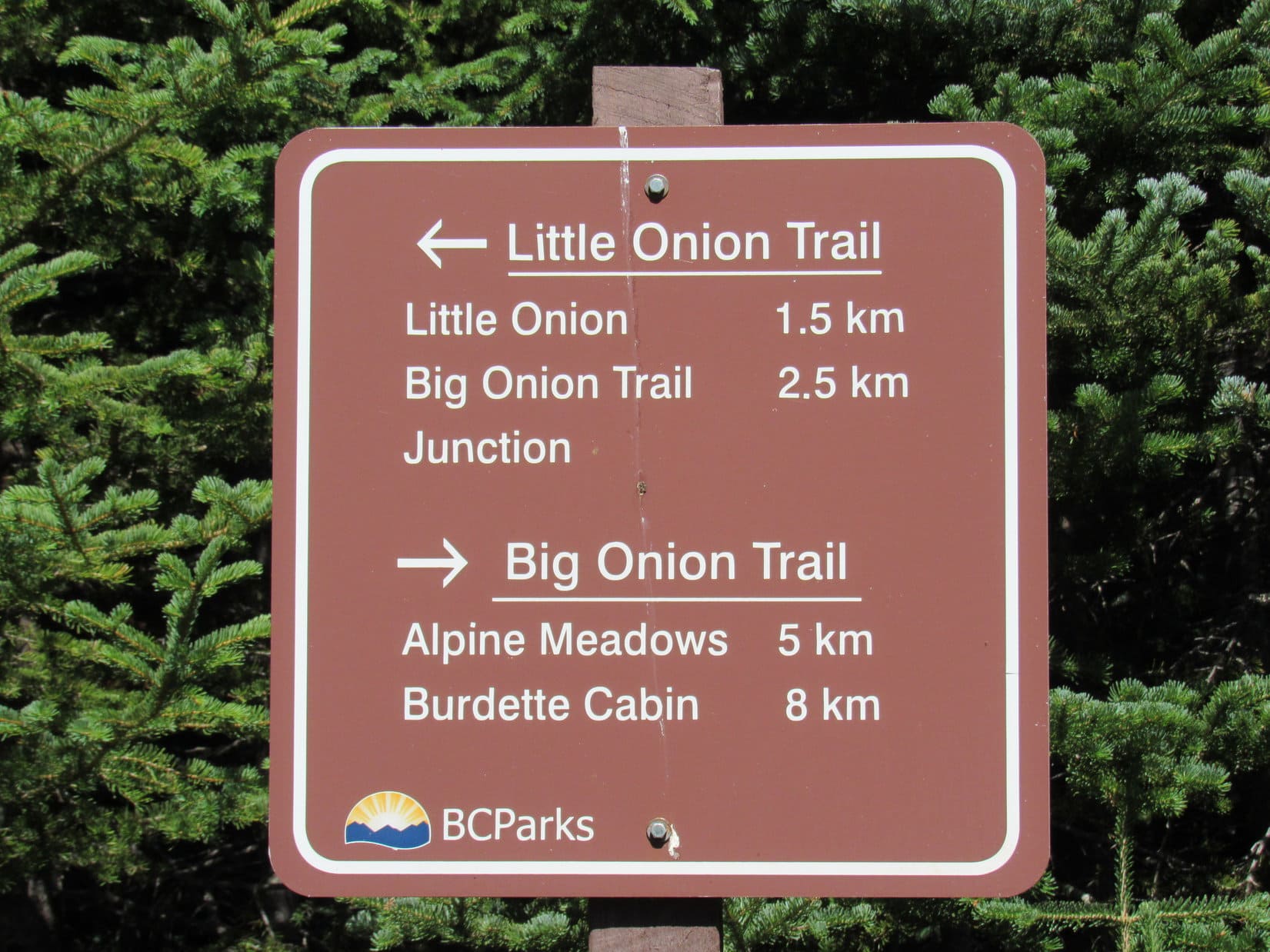
This junction was the official end of the Little Onion Trail. Looper kept going N, now taking the Big Onion Trail toward Alpine Meadows.

A little farther on, the Carolina Dog reached another signed junction. This was the critical one! Lupe had no intention of going all the way to Alpine Meadows. That wasn’t the way to Astlais Mountain or The Big Onion.
At this second junction, a road went W back up onto the ridge leading to The Big Onion. The sign said this road was the Astlais Mountain Trail. The pass below Astlais Mountain was 1.4 km away.
Great news! That was exactly where Lupe needed to go!

So Lupe abandoned The Big Onion Trail, and took the Astlais Mountain Trail W up onto the ridge. Once on the ridge, the road turned N, then subsequently deteriorated to the point where it would be impassable for any vehicle other than an ATV, or perhaps a snowmobile in winter.
The trail did go on, however, and went through a low area where Lupe came to the only water to be found all day. A trickle of a stream formed from little seeping springs ran over the road here, just enough for the Carolina Dog to get a drink. Beyond this point the trail gained elevation at a moderate pace, heading NNW along the SW slope of The Big Onion, but still far below the summit.


Worries that the trail might fade away completely proved unfounded. A much better road soon came in from somewhere off to the SW, and swung sharply around continuing toward the high saddle between The Big Onion and Astlais Mountain.

The new road promptly began climbing at an incredible pace along the very steep W slopes of The Big Onion. Lupe had no troubles, but SPHP lost traction on any loose debris to the point where walking wherever the ground looked firmest, or in piles of loose rock thick enough to offer at least some support, became standard practice.
The mere thought of being in a vehicle going up or down this road was rather frightening to contemplate. Being on paw and foot was certainly much better, even if the long trudge higher was exhausting.


It was a huge relief when the road finally began to level out. Lupe had made it to the high pass between Astlais Mountain and The Big Onion! Beyond the pass, she could see higher peaks to the N for the first time. Those peaks were in Babine Mountains Provincial Park.

After a rest break, the only question now was which to climb first – The Big Onion or Astlais Mountain? Both looked like big hills, basically easy climbs from here. The Big Onion was closer and lower. After initially starting that way, SPHP changed the plan.
Still a lovely day, but more clouds were present than only a little while ago. Maybe Lupe ought to take on Astlais Mountain first? Would be nice to get the higher peak in case the weather deteriorated fast enough to prevent the American Dingo from visiting both. Whatever! Lupe was fine with that.


So Lupe charged up the E slope of Astlais Mountain, while SPHP plodded higher. It hadn’t looked this steep! Nevertheless, this was just a big grassy trudge until fairly close to the top. The terrain then began to get rockier as the slope decreased. The huge summit region was somewhat complex with various rocky knobs and ridges among areas of tundra or bare ground consisting of small loose rock.
It wasn’t immediately clear where the summit was, but a big cairn was soon spotted well W of where Lupe had come up.


The weather hadn’t deteriorated at all during the time it took Lupe to reach the big summit cairn on Astlais Mountain (6,037 ft.). 60°F with a 10 to 15 mph SW breeze, just like at The Little Onion. A beautiful day! Which was great news. Lupe could stay a while!


Hudson Bay Mountain (8,494 ft.) and the other rugged more distant peaks to the SW and NW were all just as beautiful and interesting as they had been from The Little Onion, but the views really weren’t much different in those directions from Astlais Mountain.


The Little Onion (5,220 ft.), which had seemed such an impressive high point only a short while ago, looked small and much lower from Astlais Mountain. Lupe could see part of The Little Onion trail on the N slopes.


Smoke from the forest fires to the S could be seen actually billowing up. The wind must still have been out of the SW way over there, too. A huge plume was drifting NE.

Though Lupe had seen essentially these same views in most directions from The Little Onion, coming to Astlais Mountain had been worthwhile, for off to the N the scene was much different. The American Dingo now had a tremendous view of closer peaks in Babine Mountains Provincial Park (map).
Lupe and SPHP spent a long time gazing N at the splendors on display. SPHP knew the names of a few of the peaks. The Galleon (7,844 ft.) was the most impressive from Astlais Mountain. SPHP scanned the horizon for Mount Cronin (7,861 ft.), and thought Lupe had a glimpse of it, though partially hidden by Mount Hyland (7,478 ft.).


The highest peaks weren’t the only ones of interest. Nearly a year ago Lupe had climbed Harvey Mountain (6,083 ft.), which was off to the NNW. It would have been fun to see Harvey Mountain again, but as it turned out, Padella Peak (6,300 ft.) was in the way.


Astlais Mountain was a fantastic peak! Such a great day, and so much to see from here! 50 glorious minutes shot by at the summit. If Lupe still wanted to visit The Big Onion, too, which she did, it was getting to be time to bid farewell to Astlais. A final look at the mighty Galleon, and the Carolina Dog was on her way.


Upon leaving the summit cairn, Lupe headed E to a high point where she could look down on The Big Onion (5,840 ft.). She then headed N a little way losing elevation gradually, before turning E and descending the much steeper slope to the saddle.


Once down, Lupe crossed the saddle and headed for The Big Onion. She followed a road part of the way, and eventually reached the ridgeline a little way N of the summit. An easy, short trek S along the narrow ridge brought the American Dingo to the top of The Big Onion (5,840 ft.).

The absolute high point consisted of several medium-sized rocks amid tufts of brown grass. The summit was a mostly grassy area atop a rocky knob which dropped off steeply, though not precipitously.
The Big Onion wasn’t high enough to give Lupe quite as grand a view of the heart of the Babine Mountains to the N as she’d had from Astlais Mountain. However, she could see more territory to the E, and the view of Astlais Mountain itself was quite interesting.


Lupe relaxed and enjoyed the beautiful Babine Mountains from the top of The Big Onion for half an hour. Her journey to Astlais Mountain and both Onions had been a huge success! The day had gone far better than SPHP had ever dared to hope. Evening was approaching, however. Lupe began the trek back to the Onion Mountain trailhead.

Lupe’s route back was the same one she’d taken up. The Carolina Dog and SPHP were both in high spirits. The return trip went fast. So fast, in fact, that Loop returned briefly to the summit of The Little Onion. Even after visiting The Big Onion and Astlais Mountain, The Little Onion was still an amazing place! And far to the S, the smoke of distant fires still billowed into the sky.
Then it was down, down, all the way back to the trailhead. (7:26 PM)


SPHP stopped in Smithers for fuel and dinner from Safeway. Twilight was coming on by the time Lupe arrived at a big field along Yellowhead Hwy 16 S of Moricetown. Ancient picnic tables with white peeling paint stood on a bluff overlooking the Bulkley River.
Despite her long afternoon in the Babine Mountains, the American Dingo was still energized. She raced around the G6 playing chase with SPHP, who was, as always, totally outmatched. Lupe was happy, oh, so very happy! And seeing her so, SPHP shared her joy. What a wonderful day this had been!

Links:
Next Adventure Prior Adventure
Babine Mountains Provincial Park Map
Babine Mountains Provincial Park Brochure
Harvey Mountain, Babine Mountains Provincial Park, British Columbia, Canada (9-9-17)
Want more Lupe adventures? Choose from Lupe’s 2018 Dingo Vacation to the Yukon, Northwest Territories & Alaska Adventure Index, Dingo Vacations Adventure Index or Master Adventure Index. Or subscribe free to new Lupe adventures.