Day 4 of Lupe’s 3rd Summer of 2020 Dingo Vacation to Wyoming & Montana!
6:00 AM, near a tarn S of Two Bits Lake – An early start is a good thing, but thankfully Jobe had waited until after dawn to roust Lupe and SPHP. Took SPHP a while to pack the tiny house and everything else up, but it wasn’t too long before that was accomplished. It all had to come with. Proposed base camp on the NE shore of Varve Lake (aka Forsaken Lake) for the attempt on Castle Mountain (12,612 ft.) tomorrow was more than 3 miles away.
Yesterday evening, Jobe had still had the energy to do a little scouting along the ridge W of the stream running down from Two Bits Lake to Triskel Lake. He recommended crossing the ridge at the lower of two possible routes, which was toward the S. However, after rock-hopping the stream at a point where it was practically underground, instead of making the trek S everyone simply started straight up the short, rather steep slope immediately to the W.
The terrain up top leveled out to a considerable degree. Turning SW, Jobe led the way through some rough looking territory. Really wasn’t bad at all due to lanes of vegetation running through this region.

This shortcut soon linked up with the S route Jobe originally proposed. Traveling NW up a valley of mixed meadows and rock, it wasn’t far to a pass where Donelson Lake was in sight directly ahead.
Donelson Lake was a gem! Lupe had never been this close to it before, having seen Donelson Lake only once 7 years ago from higher up when she’d been on her way to Sky Pilot Lake. SPHP recommended going around the N shore, which worked out fine.


What lay ahead was now unexplored territory. Lupe had never been W of Donelson Lake. Responsible for enticing Jobe to take this “Lupe route” to Castle Mountain, SPHP sincerely hoped it was going to pan out, and believed it would.
The topo map didn’t look at all dicey until past Maryott Lake. What could be seen from here appeared fine. A couple of large boulders stood out up on top of a ridge not too far to the W. Maryott Lake was supposed to be on the other side of that ridge. The route up there was a little slow due to all the rock, but not difficult.
Sure enough, when Lupe reached the ridgeline, Maryott Lake was right there where it should be. Surprisingly, both Pilot Peak (11,699 ft.) and Index Peak (11,240 ft.) were in view way off in the distance, as well.


A notably higher ridge was now in view 0.25 mile off to the NW. Three small pine trees growing near the top became the next objective. Some elevation had to be lost leaving the ridge overlooking Maryott Lake, but the terrain N of the lake was relatively easy to cross. However, much rougher ground was ahead. Plenty of talus to deal with on the way up to those little pines.
Upon reaching three pine ridge, Looper not only had a terrific view of a small unnamed lake NW of Maryott Lake, but an even better view of Pilot Peak and Index Peak than before, plus a whole lot more.


Three pine ridge was connected to yet another even higher ridge due N. The Carolina Dog would have had to go over that one, too, except for the presence of a wide, flat shelf along its cliffy SW face. That shelf was a real blessing, saving close to 150 feet of steep elevation gain. Beyond it, a long snowbank could be seen draped along another ridge that wasn’t too much higher than where Lupe was now.
Scouting ahead, Jobe proved it was quite possible to get over to the wide shelf with little difficulty. Lupe and SPHP brought up the rear, as Jobe crossed the shelf to explore the region beyond it.


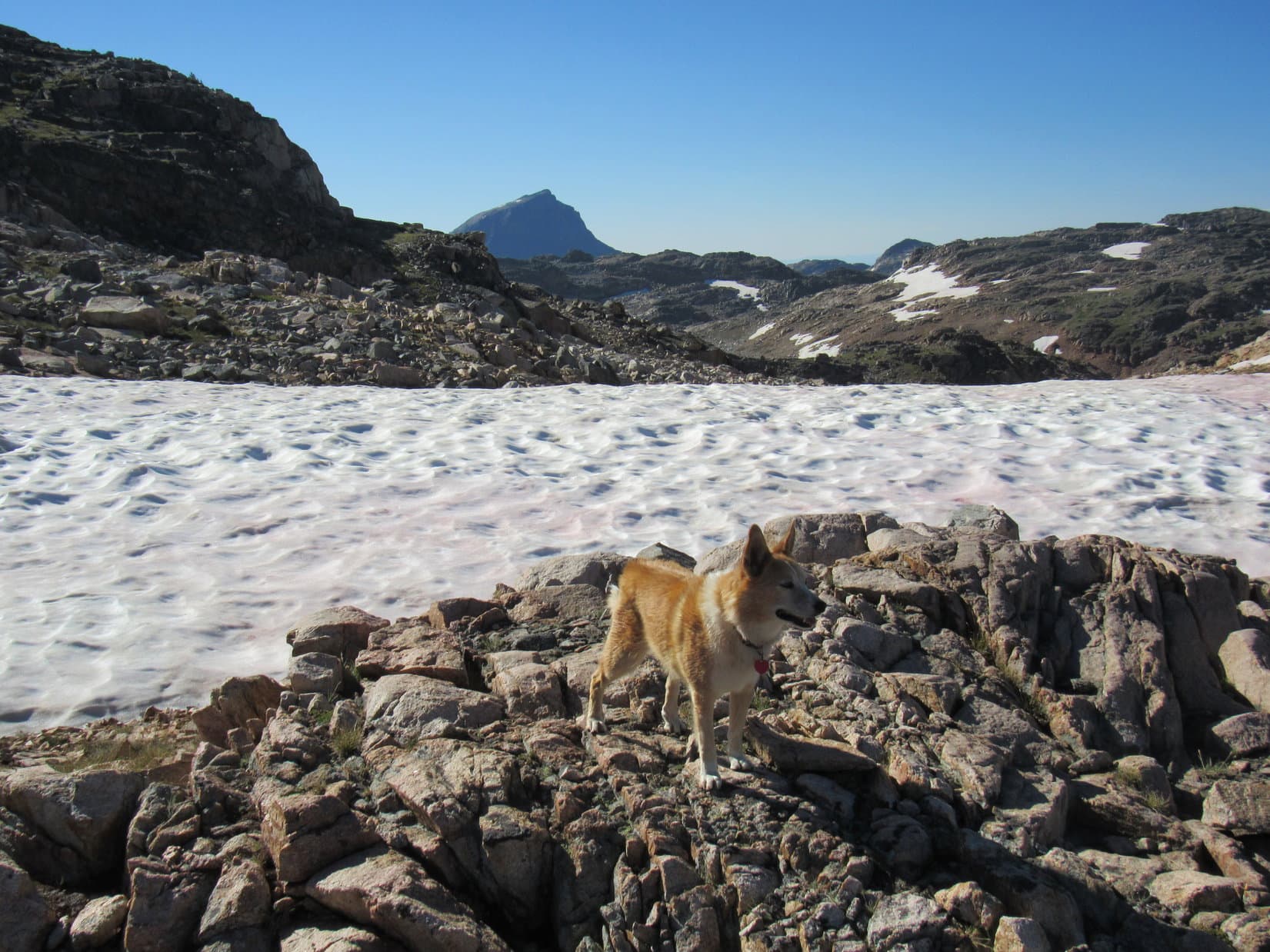
After crossing the shelf, Lupe followed Jobe through a rocky region where a little tarn could be seen to the S. This tarn was fed by the melting snows of the long snowbank only a bit higher and farther W. Upon reaching the snowbank, Loop crossed it angling toward the N (R) end.
This snowbank rested along the SE side of Pass 10660 less than 0.5 mile NW of Maryott Lake. The American Dingo was now coming to a critical point. If the “Lupe route” to Castle Mountain was going to cliff out, it might easily happen as soon as she reached the NW side of the pass, or somewhere in the next 0.75 mile beyond it.
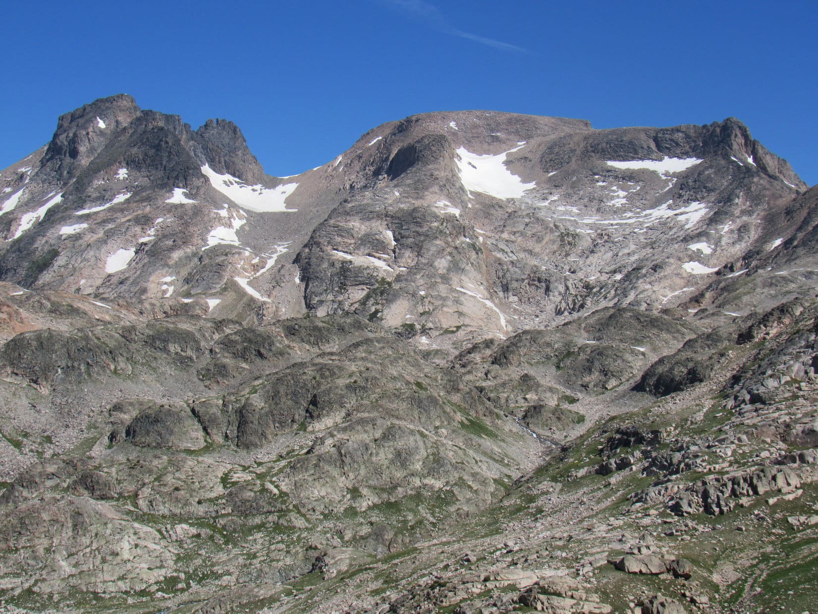
A little beyond the N end of the long snowbank, Jobe was waiting for Lupe and SPHP along the NW edge of Pass 10660. Ahead was a steep drop. The territory just S of Pass 10380, only a little more than 0.25 mile SE of Flat Rock Lake, was now in view. However, Jobe wasn’t fixated on the terrain between here and there. Instead, he stood staring curiously at Castle Mountain (12,612 ft.).
Little more than the large, gently rounded top of Castle Mountain and its steep SW flank could be seen from here. Hidden by the end of a massive ridge jutting SW from Sky Pilot Mountain (12,047 ft.), the critical S face of Castle Mountain wasn’t quite in view yet. That was where the route Jobe and Loopster would take from Varve Lake up to the summit was supposed to be.

Continuing N, Jobe led the way down a long steep slope littered with rock toward a tarn visible on a big shelf. Not too bad a descent. Patches of vegetation lower down provided some relief. Lupe didn’t get all the way to the tarn. Jobe paused upon reaching slabs of bedrock not far from it.
To the SW was an enormous canyon drained by Sierra Creek. Several of the little Pleiades Lakes were in view along with a slice of much larger Summerville Lake well beyond them.


From the slabs, another steep, rocky slope to the W finally got everyone down to a meadow. Lupe was now a good 100 feet below Pass 10380, which was still to come, having lost roughly 400 feet of elevation since leaving Pass 10660.
So far, the “Lupe route” to Castle Mountain had been viable, but not without its trials. Loop had already contended with a lot of rock, and while Jobe didn’t say anything directly against this route, he did describe this latest 400 foot descent as a future “soul-crushing” experience when the time came to ascend it during the return.
Unencouragingly, the topo map showed a similar situation lying in wait beyond Pass 10380, where another 400 foot descent would be required to get down to Flat Rock Lake. Didn’t look like it would be quite as steep as this first big drop, but it sure wouldn’t be anything to look forward to during the return, either.
No point in dwelling on that now. Turning N, Jobe, Loopster and SPHP all headed up toward Pass 10380. Near the upper end of the meadow, a giant boulder sat alone out among the wildflowers and grass. Beyond it, the terrain quickly became increasingly rocky. No doubt anxious for that first really good look at Castle Mountain, Jobe powered on ahead, disappearing over the pass.


11:00 AM, a little N of Pass 10380 – Jobe was again standing on a rock scrutinizing Castle Mountain when Lupe and SPHP caught up with him. The summit was still nearly 2.5 miles due N, but he finally had a good unobstructed view of the whole S face.
0.25 mile NW, part of Flat Rock Lake was visible 400 feet below Looper’s current position. No sign yet of Varve Lake, today’s ultimate objective. It was still hidden somewhere more than a mile away at the base of Castle Mountain.
Happily, the “Lupe route” to Castle Mountain had proven itself! No cliffs! Getting down to Flat Rock Lake looked no worse than the descent from Pass 10660 had been. At Flat Rock Lake the Carolina Dog’s route merged with the known successful approach others had taken from the S up Sierra Creek canyon. Whether Lupe’s route was any better or worse, who knew? At least it had worked.
Even so, Jobe was dismayed.


The view was disturbing. Above the region where Varve Lake had to be were 2 tremendously steep sections of slabs. Above them was a gentler region of slabs partially covered with snow. Unhappily, cliffs towered above the gentler slabs, and a humongous snowbank to the W (L) filled the entire less forbidding slope to the top.
Shortly after SPHP reached Jobe, he sighed and spoke.
Rookie mistake!
Why, what’s wrong, Jobe?
Admittedly, Castle Mountain looked intimidating. Certainly beyond SPHP’s capabilities. Sadly, that meant Lupe was never going to stand at the summit, but Jobe could make it with his vast experience. SPHP was sure of it.
Left my crampons and ice axe in the Rubicon. See that big snowfield on the L? That’s the way up. Steep enough that every step has to be perfect. 100 or more. No room for error.
Jobe didn’t have a problem with any of the rest of it, just that one darn snowfield. He hadn’t expected so much snow on a S facing slope in August. For half an hour, Jobe and SPHP stood mesmerized, pondering the situation and discussing options. Hard to tell from so far away how challenging it all really was, but from here it didn’t look like any route other than that one upper snowfield was likely to prove safely viable.
It all ended with 2 little lightning bolt words from Jobe.
I’m out!
The voice of experience. Three days short of a year ago, Jobe had been injured during a solo attempt on Castle Mountain. On the way up the West Fork of Rock Creek route intending to come over Omega Pass, Jobe hadn’t even gotten all that close when he’d been caught in a rock slide. One of his hands had gotten mangled with compound fractures.
Perhaps even more relevant, also last year, for the first time ever in his climbing career, Jobe had been “on the clock” as he put it. At a different mountain, although fully equipped, he had lost control on a snowfield, hurtling toward doom. “The clock” was a short one. Trying with all his might with precious seconds ticking away, Jobe couldn’t regain control. Not until his ice axe finally bit in at the last possible moment.
Just like that, this attempt on Castle Mountain was over. Rookie mistake! Talk about soul-crushing! After all this way. Jobe took it stoically, but had to be chagrined. Nevertheless, the mountain would still be here, he declared, and someday he would return fully prepared.
Jobe and SPHP picked up the heavy packs again.
Puppy, ho! Onward!
Only in this case, onward meant retreat.
Jobe took the lead, as always, and was soon out of sight S of Pass 10380, lost in whatever dark thoughts one experiences in such disappointment. Not far from the lone, giant boulder, Lupe and SPHP caught up with him again, where he had paused to wait. SPHP wanted to talk to him.
Castle Mountain was one of the few of 414 peaks on the list of Western Contiguous USA County High Points that Jobe hadn’t climbed yet. Nothing else around here was on any list Jobe was working. He could head on out. Lupe and SPHP would be fine. Arrangements were made for a possible Jobe/Dingo encounter at another peak in the near future.
Not even noon yet. The sun blazed overhead in a cloudless sky. Lupe and SPHP hid out in the shade of the boulder, relaxing and watching while Jobe climbed the steep rocky slope back up to Pass 10660. After losing sight of him for a little while, Jobe reappeared way up on the ridge. Half a minute later he disappeared again, this time for good. Jobe was gone.
The whole experience had been a complete waste of time for Jobe, but not necessarily for a certain Carolina Dog. Castle Mountain had always been a long shot for Looper and SPHP. Seeing Jobe again and getting to explore this route had been fun, although it was shocking and terribly sad how it had all ended in such sudden and unexpected denial.
So now what, SPHP? Are we going to go back and check out Varve Lake? See how tough that S route up Castle Mountain is up close?
Hah, no! Faintly tempting, but if Jobe isn’t up for it, neither are we. Let’s do something where we might actually stand some chance of success.
And that would be?
Where we’ve been wanting to go for 7 years now, sweet puppy!
Oh! We’re finally going to do it? Which way then?
Back the way we came. We’ve got to get back over Pass 10660, too.
SPHP had been studying the slope leading back up to Pass 10660 as Jobe climbed it. By heading farther S from the giant boulder before turning E to start up, most of the talus could be avoided. Quite a bit easier, though still a wearying steep climb. Upon reaching the ridgeline, Lupe and SPHP paused to rest and gaze back at the gorgeous territory being left behind.


More or less retracing the same route she’d taken this morning, Looper enjoyed a mid-afternoon frolic on the long snowbank SE of Pass 10660. She then crossed the broad bench N of the unnamed lake NW of Maryott Lake to reach 3 pine ridge where she could see Maryott Lake itself again.


This time Lupe went clear down close to the N shore of Maryott Lake.


4:07 PM, Donelson Lake – Upon reaching Donelson Lake, SPHP called a halt. This was it! Donelson Lake was going to be a lucky American Dingo’s home for the night. SPHP set up her tiny house E of a stream a little way back from the N shore. The sky had clouded up some after Jobe had left, and a 10-20 mph SW wind had kicked up, but it wasn’t blowing that hard here.
Time to rest! The long evening got spent relaxing both in and out of the tiny house. Dinner, with a view, of course! Lupe and SPHP didn’t know it, but Jobe was busy climbing Lonesome Mountain (11,399 ft.), visible 3 miles SSE of Donelson Lake.


If everything had gone as planned, Lupe would have been resting up NE of Varve Lake, getting ready to take on Castle Mountain tomorrow along with SPHP and her friend Jobe. Sadly, that dream had been dashed. Yet here along the N shore of gorgeous Donelson Lake, the American Dingo was perfectly positioned to take a shot at fulfilling another dream, a dream now 7 years old.
High adventure in the morning, Loopster! Guess we better hit the hay!


Links:
Next Adventure Prior Adventure
Sky Pilot Mountain, Beartooth Mountains, Montana (8-9-20)
S Route from the Clay Butte Trailhead to Castle Mountain (8-19 to 8-22, 2006) trip report by Adam Helman
West Fork Rock Creek Route to Castle Mountain (8-12-16) trip report & GPS track by Greg Slayden
Want more Lupe adventures? Choose from Lupe’s Summer of 2020 Dingo Vacations to Wyoming, Utah & Montana Adventure Index, Dingo Vacations Adventure Index or Master Adventure Index. Or subscribe free to new Lupe adventures.