6-30-20 – Hey, Loopster, come here! Get a load of this!
What is it, SPHP?
Now that we’re temporarily back from your first Summer of 2020 Dingo Vacation, I’m checking on some of the cool comments that came in for you on T(M)TAOL while we were gone. You’re never going to believe this one!
Really? Don’t keep me in suspenders, SPHP! What does it say?
Suspense, not suspenders, Loop. Anyway, here goes:
“I hope you don’t mind that I dedicated my book to you, Lupe. If you contact me, I’ll send you a free copy. Even though I’ve been in Tombstone, your adventures helped inspire it, as well as you being who you are.”
A book dedicated to me! Mind? Why would I mind? That’s a great honor, isn’t it? Who wrote that comment?
A great honor? You better believe it is, Loop! Not every day that someone dedicates a book to you. In fact, until now, not any day was. Considering that most people never ever write a book in the first place, and then that the author doesn’t even know you except through T(M)TAOL, this is like getting struck by lightning!
Actually, this is a lot better than getting struck by lightning, SPHP!
Well, of course. I didn’t mean it literally, just that this is an extraordinarily rare event.
So, you still haven’t told me who wrote that comment. And what’s the book called?
The comment is from Chinle, Chinle Miller.
Oh, Chinle! I like Chinle. Chinle has written quite a few nice comments on T(M)TAOL. You never told me she was an author, though.
There’s a reason for that. I didn’t know it, either, until now. Chinle must really like you, too, Looper. One of your biggest fans! Dedicating a book she spent who knows how long writing to you is absolute proof, as if any was needed. Why, Chinle must have been planning this for ages!
Lupe beamed from big soft Dingo ear to big soft Dingo ear.
OK! So back to the name of this book, SPHP. What’s it called? What’s it about? Can you send for my free copy right now?
Sure, we’ll send Chinle a reply. I don’t know what the book is called, but there’s a link that Chinle sent along with the comment. Let’s check it out.
The link went to an Amazon page.
Hey, hey! Here it is, Loop! Wow, totally legit! The Klondike Cafe (Bud Shumway Mystery Series Book 11) by Chinle Miller. Rated 4.7 out of 5.0 stars on Amazon! That’s mighty good. People must really like it!
The Klondike Cafe? Must be about Canada! We’ve been to the Klondike Highway and the Klondike River, right? Don’t remember ever being at the cafe, though. What else does it say, SPHP?
The cafe might be fictional, Loop. Not sure. The Klondike Cafe is a novel. There’s a synopsis. Listen to this:
“When a Mountie shows up in Sheriff Bud Shumway’s Utah office and accuses him of aiding and abetting a possible murderer in Canada’s Yukon Territory, Bud is mystified, especially since he doesn’t even know the guy. And when he receives a gold-mining claim transferred to his name and a cryptic message telling him to come to the Klondike Cafe, Bud is soon on his way, even though he has no idea where the cafe is or why his help is needed.
Join Bud on the adventure of a lifetime, as he discovers the beauty and sometimes deadly lure of the North Country, the land once charted on maps as the “Great Northern Mystery.”
A murder mystery! I didn’t expect that, SPHP, but I was right about Canada, wasn’t I? The sheriff goes to the Yukon to solve the case, and get rich mining gold! Sounds like The Klondike Cafe must have a lot more of a plot than our adventures do. We’re always like, “Here’s a cool mountain, let’s see if we can get to the top?” Usually different mountains, but sort of the same thing every time. No one gets killed on our adventures.
No, they don’t. Planning on keeping it that way, too! If people want more drama than we provide, they’d be better off reading The Klondike Cafe. Anyway, there’s more here, another link. Apparently to a bio about Chinle.
So, read it to me!
Intend to, Looper:
About Chinle Miller
Chinle Miller wanders the outback of Colorado and Utah, eyeing civilization from a safe distance. She’s accompanied by her dogs and occasional ravens.
She has a B.A. in Anthropology and an M.A. in Linguistics and an A.S. in Geology.
Short and sweet, but does sort of explain why Chinle likes you, Loop. She has dogs, and enjoys spending time with them out in remote places, just like you and me. In fact, sounds like she’s more of a real nomad than we are. Most of the time, we’re at home. Civilization does have its perks!
Oh, and she’s a geologist, too, SPHP. Which means she must like rocks. Mountains have a lot of rocks, so maybe she likes that I climb mountains? She might not be such a complete nomad like you’re saying, though. Most nomads don’t spend that much time in school. An M.A. in Linguistics! Wonder if Chinle and her dogs talk like we do?
Of course, they do. I’m sure of it! Here, let’s send Chinle a response right now. Thank her for the grand honor she’s bestowed upon you, and get that free copy of The Klondike Cafe on the way.
Chinle responded the very next day. It was going to take a little while, but she would get The Klondike Cafe sent to Lupe as soon as she could, personally autographed, no less! Amazingly, it got even better than that, as Chinle went on to say “Thanks, but you’re the real star, Lupe, and beautiful to boot! But I think you’ll like Lindie, the dingo in the book, as she’s based on you, though I make her look a little more coyote like.”
A murder mystery in the Yukon with a Dingo named Lindie playing a role! Lupe and SPHP were both excited. The Klondike Cafe was really something to look forward to!
July. Adventure season! The Klondike Cafe arrived while Lupe was out climbing mountains in Wyoming and Utah during her second Summer of 2020 Dingo Vacation. There it was, though, brand spanking new when she returned home on July 26th.
200 pages long, quick-paced, and mostly light-hearted (despite being a murder mystery!) And, oh boy, was The Klondike Cafe ever good! As the synopsis and title of the series indicated, Sheriff Bud Shumway is the star. Early on he is astonished to find himself inexplicably entangled in a murder he doesn’t know anything about, yet suspected by the Canadian Mounties of somehow having a hand in it.
Sheriff Shumway is soon reluctantly leaving his semi-capable deputy, Howie, in charge of things back in his hometown of Green River, Utah, and is on his way to the far north to figure out not only who done it, but exactly what, how, and why they’d done it. Bud’s very capable wife, Wilma Jean, a pilot and business owner, is also left behind trying to stay in touch with her husband while taking care of the watermelon farm they own, plus their two dogs Hoppie and Pierre.
Realizing this trip will be a rare chance for adventure in places he’s only dreamed of before regardless of how the murder mystery he’s wrapped up in turns out, Bud brings along his harmonica, which he is learning to play, and a camera to take photos of the Northern Lights.
In addition to all the fixes Bud finds himself in as the plot unfolds, The Klondike Cafe is sprinkled not only with brief geology lessons, but bits of information on Canadian First Nations, too. Everywhere he goes, Sheriff Shumway meets an interesting cast of characters all with problems, likes and dislikes, motivations, and dreams of their own. Meanwhile, Chinle is busy slipping in snippets of her sneaky sense of humor, as well. “Palatial Estates Trailer Park”! SPHP had to laugh, yet you just know such a contradiction in terms might actually exist.
Bud makes it to Skagway, Alaska, a major cruise ship port and start of the White Pass Railroad that goes through Fraser up to Carcross in the Yukon, passing Lindeman and Bennett Lakes along the way. The action takes him to Whitehorse, capitol city of the Yukon, where paddle wheel steamships once provided transportation and brought in supplies in the days before roads; Dawson City, heart of the Klondike Gold Rush, with its free ferry across the Yukon River to the Top of the World Highway; and up the Dempster Highway to the spectacular trail to Grizzly Lake in Tombstone Territorial Park.
Since Lupe and SPHP have been to so many of the incredible places Bud visits in The Klondike Cafe, that really helped to make it all come alive. Despite Chinle’s considerable descriptive powers, readers who’ve never been to these parts of Canada or Alaska might have a harder time fully appreciating the amazing wilderness stage upon which Sheriff Shumway’s sleuthing plays out.
For Lupe, The Klondike Cafe was more than just an exciting tale of Bud’s adventures and travails while trying to solve the mystery at paw, it was a constant reminder of all the great adventures she’d been on with SPHP in the same areas Bud was getting to know.
Taiya Inlet and Skagway (L) as seen on the way up AB Mountain to join the Arctic Sisterhood, Alaska 8-7-17Cruise ship in Skagway, Alaska 8-7-17White Pass & Yukon Route train in Skagway, Alaska 8-7-17The Most High Exalted Dingo of the Arctic Sisterhood at the Arctic Brotherhood hall in Skagway, Alaska 8-8-17Exploring past the end of the International Falls trail, which crosses the US/Canada border between Skagway & Carcross, 8-8-17On Fraser Peak, British Columbia near the US/Canada border, 8-9-17In Carcross, Yukon Territory, 8-6-17Carcross and Bennett Lake as seen on the way up Nares Mountain, Yukon Territory, 9-10-18In Whitehorse, by the S.S. Klondike, which used to ply the upper Yukon River between Whitehorse and Dawson City, Yukon Territory 8-10-17On Grey Mountain (Canyon Mountain) near Whitehorse, Yukon Territory, 9-9-18Dawson City and the Yukon River from Midnight Dome, Yukon Territory 8-23-18Lupe reaches Tombstone Territorial Park near kilometer 50 of the Dempster Highway, Yukon Territory 9-3-17Approaching Grizzly Lake. Mount Monolith (R). Tombstone Territorial Park, Yukon Territory, 9-6-17At the Dawson City General Store, Yukon Territory 9-3-17The free ferry across the Yukon River in Dawson City, Yukon Territory 9-3-17Top of the World Highway from Swede Dome, Yukon Territory 8-24-18
“They all walked inside and on to better things.” So that’s it, Looper. The end. Wha’dya think?
The Klondike Cafe was a great story, SPHP! You ought to learn to write like that. One bad thing about it, though!
Really? I thought it was terrific! What didn’t you like?
Makes me wish we were up in the Yukon having more adventures of our own right this very minute!
Yeah, me too! Sort of a fabulous trip down memory lane for us, wasn’t it? Got any favorite parts?
Oh, I liked Sheriff Shumway’s adventures and harmonica playing, but I loved Lindie best of all. So courageous! She not only helped Bud find the Klondike Cafe, she even helped solve the murder mystery, too, you know! Good press for all of us American Dingoes! For some strange reason, Carolina Dogs don’t get much of that.
So you loved Lindie best of all, Lupe? Well, knock me over with a feather. Who’da thunk it? Guess we’ve got partners now in Lindie and Sheriff Bud Shumway helping to spread the word on Carolina Dogs and their love of adventure!
Thank you, Chinle!
We’ll always treasure The Klondike Cafe! – Lupe & SPHP
North Klondike River in Tombstone Territorial Park, Yukon Territory 9-4-17Dingo endorsed!
In addition to the Bud Shumway Mystery Series, Chinle is the author of Desert Rats: Adventures in the American Outback, Uranium Daughter, The Impossibility of Loneliness, In Mesozoic Lands: The Mesozoic Geology of Arches and Canyonlands National Parks, plus several U.S. National Park guides.
After that big storm last week, I never dreamed there would be so little snow up here, Loopster! We could have gone up to the high country, if I’d realized it was going to be practically snow-free.
Still can if you want to, SPHP, but this is fine with me.
Eh, I didn’t plan anything out for up there thinking the G6 wouldn’t even be able to get close. Maybe we should just go with the flow? You can knock out a section of the Deerfield trail today. We might even have time for a side excursion to Signal Knob(6,200 ft.) for some peakbagging fun!
You know I’m not picky, SPHP. Happy just to be here! If you are, too, let’s go! Don’t want to keep the early squirrels waiting!
Somehow I doubt an American Dingo is what the squirrels are hoping for, but onward! Puppy, ho!
Lupe was on it, anxious to make tracks and get in some long overdue sniffing action. Sprinting ahead, she left the Daugherty trailhead of Deerfield Trail No. 40 following USFS Road No. 182 W up Whitetail Gulch. Daugherty Gulch was 0.75 mile S of here, and why this wasn’t called the Whitetail trailhead instead of Daugherty had always been a mystery to SPHP.
However, it was more of a curiosity than a real mystery. Whatever the answer was, it made no difference at all to Lupe.
Waiting impatiently at the Daugherty trailhead for the photo to get snapped so the day’s adventures can begin.Starting up Whitetail Gulch.
Not a cloud in the sky! Tiny sunlight diamonds sparkled on thin layers of frost and snow. The air was crisp and clean, summer’s smoky skies at long last a thing of the past. Deerfield Trail No. 40 wound gradually up Whitetail Gulch past ponderosa pine covered slopes and naked aspens. A tiny creek trickled in the ditch next to the roadbed. The road crossed it 10 minutes from the trailhead.
On USFS Road No. 182, which doubles as Deerfield Trail No. 40 in Whitetail Gulch.Loop returning from one of her romps ahead.At the tiny stream crossing 10 minutes from the trailhead.A long straight stretch bordered by white-barked aspens.
All of the terrain Deerfield Trail No. 40 would take Lupe through today was pretty easy stuff. Some variation, of course, but mostly a series of long gentle inclines and descents. A good 0.5+ mile from the trailhead, Whitetail Gulch curved S. The trail, however, continued W a little way before making a short steeper jog up to the N. Turning W again, the road leveled out, reaching a high point shortly after passing No. 182.1D, a side road on the R (N).
Just beyond this high point, the Deerfield Trail curved SSW as it began a gradual descent. Some open ground provided Lupe with her first views of nearby hills. Nothing too spectacular, but pleasant enough.
At the curve beyond the junction with USFS Road No. 182.1D. Photo looks SW.
Lupe was soon past the open grassy region. The trail now dipped more steeply down into a shady canyon, entering a different drainage. At the bottom, the road crossed Crooked Creek, which was considerably larger than the tiny creek in Whitetail Gulch, but still a small stream. Paving blocks in Crooked Creek made for a trivial stream crossing.
Immediately beyond Crooked Creek, the road forked. A brown Deerfield Trail fiberglass wand was in sight ahead along the L branch. Going that way, Loop quickly came to a second Crooked Creek crossing, also blessed with paving stones.
At the first Crooked Creek crossing. Stay L at the road fork ahead!The second Crooked Creek crossing was only a few hundred feet farther.
Crooked Creek was a major low point. From here, Deerfield Trail No. 40 climbed steadily following the creek valley higher. Within 10 minutes, Lupe arrived at another place where the road forked. She stayed to the R entering a shaded, narrower portion of the valley. A snowy trek on a straight stretch led to a curve to the L where the road crossed Crooked Creek yet again, which this time flowed beneath it in a culvert.
Immediately beyond the culvert crossing, the road curved sharply R (NW), starting up a hill at a steeper pace. However, Deerfield Trail No. 40 parted from the road at this curve. SPHP nearly missed the trail as it headed off to the L. The only sign was 25 feet from the road where a big ponderosa pine had a metal “40” diamond nailed to its trunk, and a pink ribbon could be seen behind it flapping in the breeze.
Heading W up the S side of the Crooked Creek valley after the 2nd stream crossing.Looper at the fork 10 minutes W of the 2nd Crooked Creek crossing. Stay to the R here!By the big ponderosa pine with the 40 diamond and pink ribbon. The trail has just left the road 25 feet back and is now a single track. Don’t miss this turn! Photo looks SW.
Deerfield Trail No. 40 now continued SW up Crooked Creek as a single track. At first, the single track looked a little like an abandoned ATV trail, but soon lost that characteristic as it promptly entered a narrow, V-shaped valley. The shady forest seemed dank and dark, but the trail was easy to follow.
Before long, Lupe came to another creek crossing. This one was a bit of a mess. A mostly frozen-over pool of water was surrounded by deadfall and tree trunks that had been cut to clear the trail, but which were still crowding the crossing. The ice wasn’t thick enough to be trusted, and getting past this little spot was more trouble than it ought to have been. On the far side, SPHP had to crawl under a downed spruce, but the Carolina Dog enjoyed plenty of clearance.
As it turned out, Loopster came to 3 of these stream crossings in quick succession. None were significant obstacles, but they did slow SPHP down, which admittedly doesn’t take much.
First of the 3 Crooked Creek crossings that came in rapid succession.Second crossing. The log next to Lupe would have made this one a cinch, if it hadn’t been icy.
Shortly after Lupe passed the third stream crossing, the valley turned S and began to open up. The single track reached an old forest service road again, which continued up the valley at an easy pace, crossing Crooked Creek one last time at a point where the stream was a simple rock hop, almost a step-across.
The old road eventually began curving R (W), and soon arrived at a 3-way junction at a sunny clearing. Another 3-way junction was just 150 feet away up a hill to the S. A check of SPHP’s maps showed that all Lupe had to do was continue straight W on a road clearly marked as USFS Road No. 443.
The valley opens up after the 3 rapid succession stream crossings. Loop is approaching a final easy Crooked Creek ford just ahead. Photo looks SSW.Still following Crooked Creek higher, but we won’t have to cross it again! Photo looks SW.2 different 3-way junctions in this area. Stay straight W on No. 443! Photo looks WSW.
No. 443 headed W from the junction, then gradually curved NW. What was left of Crooked Creek was still on the L (S) side of the road, but was now largely reduced to a strip of mucky terrain with only a little free flowing water among tufted grasses. A little after No. 443 turned NW, Lupe reached an unmarked fork.
Directly ahead, a grassy slope lay between the two choices, either a road to the R (N) which went uphill into an area where several trees had pink plastic ribbons tied around them, or a road to the L (W).
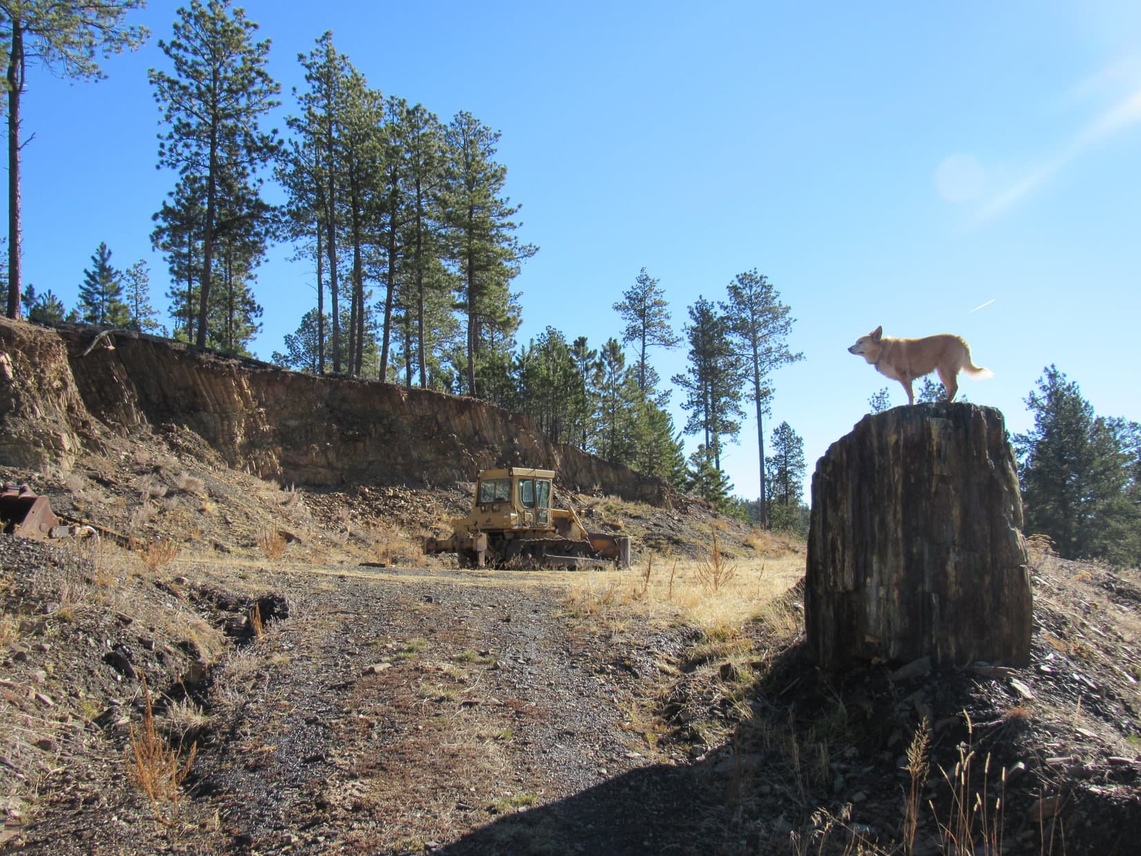
The road to the L looked more heavily trafficked, as though it might be a continuation of No. 443. After some debate, Lupe went that way. She soon came to a place where the hillside N of the road had been carved away by a bulldozer. In fact, the guilty bulldozer was still rusting away up in the scar. Orange signs in the trees nearby said this was an “active” mine site, but it sure didn’t look like it.
Part of the carved up hillside N of the trail. Photo looks E.Looking ahead. No. 443, if that’s what it still was, continues W. Photo looks W.
Continuing W past the inactive active mine site, the road soon curved NW again, leaving the last remaining trickle of Crooked Creek behind for good. Lupe came to a 3-way junction in a large clearing. A tree on the E side of this junction had a 40 diamond nailed to it. The positioning made it look like this meant the road heading NE up a little hill was actually the Deerfield Trail, not the way Loop had just come.
Wondering if the road from the NE was a continuation of the branch to the R that Loopster had not taken at the last fork before the mine, SPHP led her up to the top of the little hill. Off to the L (N) was a somewhat higher ridge that looked like it might provide some distant views. The road kept going NE, instead of bending around to the R (S) like it should have if it was going to head back to that last fork.
Inconclusive. Didn’t really matter. SPHP was certain Lupe needed to go back down and take the road going SW. She sure didn’t need to be going NE. Might as well forget this for now. Maybe the Carolina Dog had taken a little shortcut by going past the mine, and maybe she hadn’t, but it was true that she hadn’t seen any 40’s along the road that went by the mine.
Lupe reached this junction from the R (SE). However, the 40 diamond on the pine at R seemed to indicate that this road to the NE (Center) had been the correct route. Photo looks NE.On a brief foray to the NE to see if this was the route Lupe should have been on. Result: inconclusive. Photo looks NE.
Lupe turned around, went back down the little hill, and continued SW past the 3-way junction. The road climbed gradually for a while, then leveled out. Was this the place? Nothing stood out, but then again, that was to be expected. There wouldn’t be anything to make it stand out. A brown fiberglass “40” wand confirmed Loopster was definitely on the Deerfield Trail again.
On the flat high ground. Photo looks SW.
A long time ago, the Carolina Dog had been this way. In fact, back in the early days of her Black Hills expeditions she had traveled both the entire Deerfield and Centennial trails, among the longest in the Black Hills. That was years before she had her very own adventure Dingo blog. In the last few years, Loop had revisited some sections of both trails, which was more or less what this expedition was all about, too.
Today’s re-exploration had all seemed like a completely new voyage of discovery. Nothing had triggered memories of having been here before until now. Yet a growing eerie feeling of long lost familiarity still wasn’t conclusive.
Keep an eye out, Loop. I think somewhere up here the trail veers off to the R, going downhill as a single track again. If I remember right, the turn is marked, but still easy to miss.
I’ll try, SPHP, but I’m sort of busy watching for squirrels and deer, too. Are we close to the turn you’re expecting, now?
Not sure. Suddenly feel like I’m in an ancient dream walking in a real, but long forgotten land. All I really remember is being up on a stretch of flat high country like this that didn’t offer any views, and subsequently missing the turn. That scarred hill and rusting bulldozer we passed now seem vaguely familiar, too, but I could be confusing all this with some other completely different place.
Well, that’s really helpful, SPHP! Let me know if your dream walk is due to turn into a nightmare somewhere up here. Think I’ll stick to the squirrels and deer in the meantime.
The march SW went on and on, just like SPHP “remembered” it would, but Lupe still didn’t come to anything definitely recognizable, and no single track trail appeared veering off to the R. Instead, Loop eventually came to a 3-way junction SPHP had no recollection of at all with USFS Road No. 429, which was marked with a brown wand and continued SW.
So here we are up in dreamland! Flat high ground, pine trees, no views, but an easy trek. Photo looks SW.So far, so good, but still no single track off to the R (NW)! Photo looks SW.Junction with USFS Road No. 429. (Near HP6006 on the topo map.) Photo looks SW.
No. 429 soon started dropping. Slowly at first, but Looper hadn’t gone far before she was losing elevation at a good clip. She came to a place where the road curved R (N) into a valley. SPHP called a brief halt to check maps, and take a little break. A building was off to the SW on a partially open hillside of mixed grasslands and pines.
Well, we’ve done it again, Looper.
Done what, SPHP?
Missed the turn onto the single track. No harm done, though. I suspect we’ll find it right around this bend. That grassy hillside with the building makes me think we’re getting close to Slate Prairie.
Off the official Deerfield Trail a bit, but getting close to Slate Prairie. Photo looks SW.
Loop wasn’t hungry, but SPHP ate an apple. Once it was gone, onward!
Apparently, the few brain cells that hadn’t suffered a memory dump were right. Continuing around the curve down into the valley to the NNW, Deerfield Trail No. 40 crossed the road only a few minutes from the rest spot.
By the section of single track trail Lupe’d missed. It provides a little shortcut compared to following USFS Road No. 429 around a bend to the S. Photo looks E.From USFS Road No. 429 (which Lupe is standing on), Deerfield Trail No. 40 continues as a single track up the ravine seen beyond her. Photo looks SW.
Leaving No. 429, Lupe turned WSW following a single track up a ravine. This ravine was the upper end of the Bittersweet Creek drainage, a very small stream at this point. The creek was a mucky mess where the trail first met it. Loop avoided crossing it, staying along the S bank for a little way, waiting until SPHP found an easy spot to leap over.
A use path on the N bank led up to a boulder where it merged with the official Deerfield Trail. The use path contained a hazard the official trail did not. Several strands of rusty barbed wire from a downed fence were hidden in the grass just before the boulder. Fortunately, Lupe did not get tangled in it.
An American Dingo forges ahead after successfully avoiding a barbed wire trap only a few feet from this rock. Photo looks SW.
Following the official trail up the ravine, Loop came to a flat region on the edge of Slate Prairie. Signal Knob(6,200 ft.) could now be seen 0.6 mile to the SSE.
Heading up the ravine. Photo looks W.Approaching Slate Prairie. Photo looks WSW.Signal Knob from Deerfield Trail No. 40. Photo looks SSE.
Signal Knob wasn’t impressive, merely a small pine-forested hill isolated out in the Slate Prairie grasslands. Lupe had been there before, more than 5.5 years ago. SPHP remembered a deadfall timber laden summit due to a severe pine bark beetle infestation.
Noon already, but Looper had been making fairly decent time. She was only a little over a mile from the Kinney Canyon trailhead, her minimum goal along the Deerfield Trail today. No more significant peaks were close to this section of the trail, so SPHP figured the Carolina Dog might as well pay Signal Knob another visit. The side trip would cost her an hour or so, but no more than that.
Leaving Deerfield Trail No. 40, Loopster struck out heading S across the rolling grasslands of Slate Prairie. After crossing a ravine containing what remained of tiny Bittersweet Creek, she passed through a big field leading to County Road No. 307. Ducking under a fence to cross the road, she was soon approaching Signal Knob from the NW.
Approaching Signal Knob. Photo looks SE.
The N end of Signal Knob was private property, but the S half was USFS land. Lupe circled S partway along the W slope before turning toward the summit. The entire W slope was a mess of deadfall and stickers, making what should have been a trivial romp higher a slow process.
Signal Knob is sort of a mess, but we knew that! Photo looks SE.
As expected, Signal Knob’s flat summit was still littered with deadfall, but patches of open ground existed, too. Despite the pine bark beetles’ work, enough trees were still standing to interfere with the views. The only really clear view was a nice one of Black Elk Peak(7,231 ft.) far to the SE. The last time Lupe had been here, it had still been Harney Peak.
Black Elk Peak (L of Center) from Signal Knob. Photo looks SE.Black Elk Peak with help from the telephoto lens.
12:29 PM, 55ºF, Signal Knob – A 10-15 mph breeze blew out of the W, but it was still nice up here for almost the end of October. SPHP was glad Lupe had returned to Signal Knob. However, if she was going to get as far along Deerfield Trail No. 40 as SPHP hoped, Loop couldn’t stay long.
Time enough for a relaxing light lunch, and that was about it. Taste of the Wild for Lupe, who was somewhat hungry now. Another apple for SPHP. A small chocolate coconut bar served as desert. Naturally, it got shared with the insistent sweet tooth Dingo.
Back on Signal Knob for the first time in more than 5.5 years. Photo looks NW.Relaxing a bit before pressing on. Photo looks S.
A pleasant 20 minutes, and it was time to go. At least the Carolina Dog had one minor peakbagging success to show for the day! Bidding Signal Knob farewell, Lupe started down the W slope again. The lower part wasn’t forested, and actually provided quite nice views of the E edge of the limestone plateau region off to the W.
South Castle Rock (Center) and Castle Rock (R of Center), both part of the same ridge. Nipple Butte (far R). Photo looks NW over Slate Prairie and more distant Reynolds Prairie with help from the telephoto lens.View to the SW from the lower W slope of Signal Knob.
Once down off Signal Knob, Lupe went NW intent upon getting back to Deerfield Trail No. 40 again. She didn’t return to it at the exact same spot she’d left it, but picked the trail up somewhat farther W where it crossed USFS Road No. 187.
In Slate Prairie, almost back to Deerfield Trail No. 40. Flag Mountain(6,937 ft.) (far L), Peak6962 (L), and White Tail Peak(6,962 ft.) (R) in the distance. Photo looks NW.Back at the Deerfield Trail where it crosses USFS Road No. 187. South Castle Rock (straight up from wand). Photo looks WNW.
From USFS Road No. 187, the trail left Slate Prairie heading W into the trees. Lupe soon came to a metal gate. At roughly 6,220 feet elevation, this gate was the highest point along the entire Deerfield Trail. From here the trail continued WNW on a long gradual descent. At the bottom, Lupe popped out onto County Road No. 307 again, the same road she’d crossed near Signal Knob.
On the other side of No. 307 was a big grassy clearing, site of the Kinney Canyon trailhead.
At the metal gate W of USFS Road No. 187. This is the high point of the entire Deerfield Trail. Photo looks W.Losing elevation after passing the gate. Photo looks WNW.Looking back from County Road No. 307. Photo looks ESE.At the Kinney Canyon trailhead. Photo looks W.
Not yet 2:00 PM, but close to it. Looper had met her minimum goals for this Black Hills expedition. Sure would be nice to continue far enough to link up with the Deerfield Lake Loop Trail No. 40L, though. Another mile would almost do it. SPHP actually hoped the American Dingo could get even farther than that.
Wha’dya think, Loop? How are you feeling?
Great! What’s up?
We can turn around here and call it a day, but want to keep going? Be kind of fun to go all the way to the Deerfield Reservoir dam and see the lake. On the other paw, the sun goes down mighty early these days. We won’t get back to the G6 until well after dark, if we do all that.
I’m having a blast! Let’s keep going! You brought the flashlight?
Yup. Extra batteries, too, if we need ’em.
So onward it was! From Kinney Canyon, the Deerfield Trail continued SW up a little valley, now as a road again. Shortly after the trailhead was out of sight, however, the trail veered off to the R as a single track. A steady climb eventually leveled out in a young pine forest.
SW of the Kinney Canyon trailhead, the Deerfield Trail again becomes a single track as it splits off here from a short stretch of road it had been following. “40” trail wand beyond Lupe. Photo looks W.In the young forest at the top of the next rise. Photo looks WNW.
A long descent was about to begin. Beyond the young pines, Lupe went through a second metal gate. Past the gate, she came to a big field. On the far side was a road. The last of the single track trail led over to it.
Last of the single track trail. The road leading to the junction with trail No. 40L is just ahead. Photo looks W.
Upon reaching the road, Lupe followed it R. It immediately entered the shade of a forested valley. The snowy road lost elevation more quickly than the single track had, but wasn’t steep. Winding W down this valley, Loopster came to a sign for the Deerfield Recreation Area. The junction with Lake Loop Trail No. 40L couldn’t be much farther.
A few more bends in the road, and there was the intersection at a small sunny clearing.
On the snowy road. Photo looks WNW.Entering the Deerfield Recreation Area. Photo looks NW.We’re getting close to the junction with Lake Loop Trail No. 40L now! Photo looks W.This is it! W end of the official Deerfield Trail No. 40. Of course, it links up with No. 40L here, which goes clear around Deerfield Lake. Photo looks SW.
A couple of signs were at the junction of No. 40 & No. 40L. One said Loop was now 7 miles from the Mystic Road trailhead, which is just another name for the Daugherty trailhead. The other sign said the Custer Trails trailhead, accessible from No. 40L, was 2 miles away.
W end of Deerfield Trail No. 40. The E end links up with Centennial Trail No. 89.Still at the junction, but on Deerfield Lake Loop Trail No. 40L now. Photo looks N.The second sign.
Only one more objective left! Lupe headed NW on Deerfield Lake Loop Trail No. 40L. Castle Creek wasn’t as far as SPHP remembered, only 0.33 mile. Another 0.33 mile past Castle Creek, and the Carolina Dog reached the top of the Deerfield Reservoir dam near its NW end.
Approaching Castle Creek below the Deerfield Reservoir dam. Photo looks NW.Deerfield Reservoir from the NW end of the dam. Photo looks SSW.
A cool W breeze swept across the lake. Trotting along the length of the dam, Lupe headed for a grassy region at its opposite SE end. Leaving the dam, SPHP walked along a steep slope below a fence, stopping to rest where as much of the lake was in view as possible. Loopster thought this slope was a little too steep, but SPHP helped her get comfortable.
Deerfield Lake from farther along the dam. Photo looks W.Looking back along the dam. Photo looks NW.The grassy slope. Photo looks W.
Tall strands of yellow grass danced in the wind. Sunlight glittered on Deerfield Reservoir as an unceasing parade of shimmering blue waves rippled into the dam’s rocky shore. Beyond the lake were ponderosa pine forested hills and ridges of the western Black Hills, dark green nearby, bluer in the distance. Other than the wind sighing in the pines, silence. Solitude.
Most of the rest of the Taste of the Wild disappeared. The last chocolate coconut bar vanished. Partially resting on SPHP’s lap, Lupe stayed a while, watching the waves.
3:11 PM, Deerfield Reservoir – Two hours until sunset. Nearly 8 miles to go. Better get with it! The American Dingo paused at the SE end of the dam for a final look, and was on her way.
Deerfield Lake.
The return was fun! Such a beautiful evening! Returning to Deerfield Trail No. 40, Lupe headed E. Long uphill and downhill stretches, but never very steep, and more downhill going this way than uphill. No rest breaks, no photo stops, no side trips, except a brief one that proved the road past the bulldozer and the inactive “active” mine site really was part of the official Deerfield trail.
Looper sniffed and explored to her heart’s content. In Slate Prairie, she saw cattle grazing in the fields N of Signal Knob. Later, she came upon several small groups of whitetail deer in the Crooked Creek valley.
Minus the stops, it all went by much faster than before, yet the last rays of sunlight vanished and dusk came on. A bright star appeared, most likely a planet, and as the darkness grew, a circular glow highlighted the black outlines of pines in the E.
Tomorrow was Halloween, and October’s second full moon – a blue moon. It was nearly full tonight. As the moon rose above the treetops, Deerfield Trail No. 40 became a mix of shadows and moonlight, where a homeward bound Carolina Dog roamed at will. (End 6:54 PM, 50ºF)
Signal Knob (R) from Deerfield Trail No. 40, Black Hills of South Dakota 10-30-20