
Day 17 of Lupe’s Summer of 2016 Dingo Vacation to the Canadian Rockies, Yukon & Alaska.
Was it foggy? No, only condensation inside the G6. Stepping outside, the sky was overcast. No sunshine at all, but the clouds were pretty high. Most of the mountaintops were in view. Hopefully, the clouds would burn off as the day went on.
Yesterday’s feeble attempt to climb Dillon Mountain had ended before Lupe even gained any elevation. It was SPHP’s fault. SPHP had fallen into a blueberry trap. All ambition had drained away as SPHP consumed blueberries, and Lupe dozed on the soft, spongy tundra. The whole attempt had been doomed from the start, anyway. The previous day’s climb of Sukakpak had sapped both Lupe’s and SPHP’s energy.
Today, though, this was it. Now or never. Lupe and SPHP left the G6 (9:41 AM, 57°F) parked N of milepost 207 along the Dalton Highway, and headed S. Lupe followed a faint road through the forest, and then animal trails to the edge of the swamp. Instead of trying to go SE through all those terrible tussocks again, this time Lupe went SW to the river.
Following the Bettles River S, Lupe made much faster progress than yesterday. Part of the time it was possible to travel over exposed parts of the riverbed. Other times, the river forced Lupe and SPHP up onto the E bank, where there were usually trails to follow. Lupe was gaining on her first objective, a low saddle between Dillon Mountain and High Point 2003.

Lupe turned SE, leaving the Bettles River when she got close to High Point 2003. Lupe and SPHP crossed a lot of spongy ground on the way up to the saddle between High Point 2003 and Dillon Mountain. Despite occasional wet areas with annoying tussocks, Lupe had avoided nearly all of the difficult tussock-infested swamp NE of the river.

As a guide, Lupe and SPHP were using a copy of a Peakbagger.com trip report on Dillon Mountain (4,820 ft.) written by Richard Carey. Carey, a highly experienced mountaineer, was the only Peakbagger.com account holder ever to have reported climbing Dillon Mountain. Carey had climbed the mountain more than 21 years ago on August 4, 1995.
Carey’s trip report mentioned an old road in the saddle, but Lupe did not come to it. Lupe and SPHP were staying on the S side of the saddle close to High Point 2003. Maybe it was more toward the other side of the saddle, closer to Dillon Mountain? Or maybe 21 harsh Arctic winters had obliterated the old road?
The ground was spongy with tundra moss, but otherwise travel wasn’t difficult through the saddle area. Lupe and SPHP gave up on finding the old road, instead following animal trails that Lupe kept coming across. According to Carey, the next objective was to reach Dillon Mountain’s S ridge, which was still a mile to the E.
As Lupe continued SE beyond High Point 2003, she came to a wide grassy area free of the tall dense bushes that grew nearby. During wetter periods, the entire grassy area might well be a fairly large pond, but only a remnant pond was here today. The grassy area was easy traveling. Lupe and SPHP went along its NE edge.

Lupe left the grassy area and High Point 2003 behind, re-entering the forest. She angled E, toward Dillon Mountain, crossing the saddle to avoid losing elevation. Soon she started a moderate, steady ascent traversing Dillon’s lower slopes.
Carey advised getting up onto Dillon Mountain’s S ridge, but not until beyond the steep eroded cliffs on the upper portion of the ridge. A glance at the mountain made it easy to see why.

It wasn’t clear exactly how far Lupe needed to go before attempting to climb up onto the huge S ridge. Lupe and SPHP simply pressed on toward the lower end of the ridge looking for any promising way up.
In the forest, Lupe crossed three boulder fields left by landslides. The first one was small. The next two, considerably larger. When Lupe reached the third boulder field, a forested ramp was visible on the far side.

Lupe crossed the boulder field, continuing on to the base of the forested ramp. The ramp was quite steep and fairly narrow, but Lupe began the ascent. Trees and bushes made some parts of the climb annoyingly slow for SPHP, but there was nothing new about that.
About halfway up, water was dripping from the rock wall next to the ramp. By now, it was sunny and warm, the clouds having dissipated somewhat. Lupe seemed to like sitting in the cold dripping water. SPHP immediately dubbed this place the “Dingo Shower”.

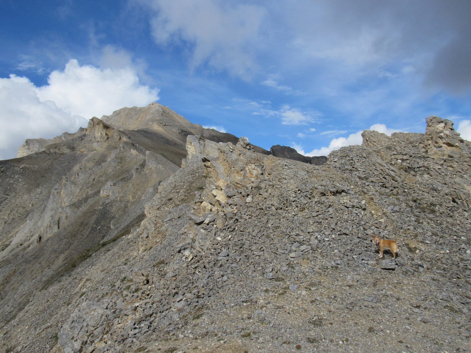
Lupe and SPHP made it to the top of the ramp. There wasn’t really any clear spot where Lupe gained the S ridgeline. Instead, she kept coming to and climbing up a series of benches. All these benches were forested, relatively steep, and separated by stretches of even steeper ground.
The climb went on and on. Lupe gained lots of elevation. SPHP kept trying to lead Lupe toward the NE to see what was on the other side of the ridge, but the ridge was very broad. For a long time there was no open view. Eventually, though, the trees began to thin out.
Finally, Lupe made it above tree line. A steep, open slope continued relentlessly higher. Looking E toward Wiehl Mountain, SPHP could see Lupe must still have a big climb ahead. Wiehl Mountain still looked much higher than where Lupe was.


Lupe climbed and climbed. SPHP started to become concerned. Carey had warned in his trip report that the S ridge was complex. About 4 uplifted bands of rock run E/W across the main S ridge. Carey said they were more easily crossed lower down on the E side.
Lupe was getting mighty high up. Although SPHP had been trying to head NE, the S ridge was very broad. As far as SPHP could tell, Lupe hadn’t gotten around any uplifted rock bands yet. Fear grew that Lupe was going to arrive up on some kind of dangerous pinnacle with no way forward.

At last, a little tor appeared high above Lupe, perched up at the end of the long slope. As Lupe worked her way up to it, SPHP wondered if it was the “Tor of Glad Tidings” or the “Tor of Doom”? The answer would be clear soon.

Lupe reached a shallow saddle at the top of the slope. SPHP’s heart sank. It was the Tor of Doom! Some sort of cliff was almost certainly just out of view beyond it.
The summit of Dillon Mountain could be seen ahead, still many hundreds of feet higher, at the end of the long, jagged S ridge. SPHP had made the fatal mistake, warned against by Carey, and led Lupe straight on up the S ridge to the uplifted rock bands.
Gah! How sickening! Was this defeat? How was Lupe ever going to get to the summit? Going all that way back down to try again farther E was unthinkable. Just getting this far had sucked up so much energy and time!
There was a rounded flat area to the NE, a little higher than the Tor of Doom. Glumly, SPHP climbed up there to take a look around. If nothing else, it was time to take a few photos of how far Lupe had made it. Lupe followed along as happy as a clam.
Sure enough, there was a cliff directly ahead. It wasn’t all that high, maybe 20 feet? Didn’t matter. No way was SPHP going to attempt to navigate it, or let Lupe get hurt trying it either. Even if Lupe could get past this cliff, it looked like a series of cliffs continued along the ridge. SPHP tried to figure out where Lupe was on the topo map. Around 700 feet below the summit seemed likely.
Dang, Carey! Why did he have to be so right?
Well, because he’s an extraordinarily experienced mountaineer! Over 2,600 ascents logged on Peakbagger.com on 6 continents around the world! His top 10 ascents are all over 15,000 feet, the top 2 over 20,000 feet. You did notice that, didn’t you, SPHP?
Oh, thank you so very much Looper! And I’m just a foolish day hiker way out of my league. I get it, and it’s plainly hard to deny given where we are right this very minute!
No need to get sore about it, SPHP, you asked. I still love you, and this is a fabulous spot. Look at the views! Aren’t you all about the views? What’s wrong with this? What a glorious place!
You’re right, of course. And I still love you, too Loop, so very much. The views are fabulous, and we are extraordinarily lucky to be here. The only thing wrong about this place is it’s not the summit, and there doesn’t appear to be a way to it without going way, way back down the mountain. There’s not enough time to do that, even if I had the energy. I thought we were going to make it. Look over there, the summit’s not all that much higher than where we are now, not compared to how far you’ve already come! Anyway, you’re right, picture time. We’ll take a break and think about what to do next. Maybe we’ll come up with something.
Why hadn’t SPHP thought this all through better when clearly warned? Nothing to be done about it now. Take those pictures. Lupe had certainly made it to a dramatic and beautiful spot.


Hey, wait a minute! While taking the last photo, SPHP noticed a wide ledge of relatively level grassy ground in an unexpected direction. It was close by to the SW, only a little below the cliff where Lupe and SPHP were standing. Was there a way down to it? Did it lead anywhere?
Lupe went back down to the small saddle below the Tor of Doom. SPHP had thought there was nothing but a fearsome cliff beyond the saddle. Getting closer to the other side, there was a huge cliff, but there was also a rocky chute leading directly down to the grassy ledge. The ledge appeared to go up and around the 20 foot cliff Lupe and SPHP hadn’t been able to get beyond!
Looper! It’s your Luck of the Dingo again! Looks like we can at least make it to the next uplifted band of rock. Come, on!
Lupe was already leading the way. SPHP picked a way down the steep, rocky slope. Soon Lupe stood on top of the next band of rock. Once again, there appeared to be no way forward along the ridge, but at least Lupe was past the first cliff now!


On top of the second rock band, Lupe was a little higher than before, and a little closer to the summit. The view ahead was still disconcerting. More rock bands and more cliffs. They looked impassable. Now what, indeed?
Looking around, it appeared that Lupe might be able to get by this 2nd cliff by following the rock band she was on down to the SE. About 150 feet lower, the rock band looked like it broke up enough to destroy the cliff’s continuity. Lupe should be able to get around it down there. Only 150 feet of elevation loss was tolerable, but once she was beyond the 2nd rock band, then what?
The valley between the main S and E ridges was in view. Off to the NNE, SPHP could see sort of a gap in one of the biggest bands of rock sloping down the mountain. The gap was at a point not too far below Lupe’s current elevation. If she could get around this 2nd cliff, and make the traverse over to and through that gap, she would be well on her way to the middle of the SE valley. The SE valley was very steep, but maybe Lupe could climb straight up it?
Well, Loopster, that valley doesn’t look any worse than Decoeli (7,650 ft.), and you made it up that. Let’s see if we can get over there.
150 feet of elevation loss to get around the 2nd cliff turned out to be more like 300 feet. Lupe was 1,000 feet below the summit again, but at least she could resume climbing slowly once more, while angling toward the gap. More importantly, by staying well below the S ridgeline as Carey had advised, Lupe could hopefully bypass any more difficulties with cliffs and rock bands.
The summit of Dillon Mountain disappeared from view. A cloud passed over, sprinkling rain. SPHP called a halt to put on an old blue plastic rain poncho. It wasn’t very good, but helped some.
That’s your emergency rain gear, SPHP? You look like the Cookie Monster!
Yeah, yeah, let’s go, Dingo!
The plan worked! Lupe and the Cookie Monster made it to the gap and beyond. Blue sky reappeared. The blue rain poncho went back in the pack. Lupe reached the middle of the SE valley. SPHP began plodding slowly straight up the steep slope. The climb was easiest where there was a little heather, and not just loose rocks. Fortunately, for a while, there were plenty of heather routes to follow.
Way down below, something was moving! A small herd of mountain goats was running single file across the valley. They disappeared over one of the rock bands of the S ridge.


The steep climb seemed endless. Lupe became bored with SPHP’s dreadfully slow pace. She began roaming at will all over the vast SE valley, as if she was a mountain goat herself. She often went out of SPHP’s line of sight, reappearing suddenly hundreds of feet above or below. She returned frequently to check on SPHP’s snail-paced progress.
The energy Lupe displayed was astounding! Once, SPHP became worried. Lupe couldn’t be spotted anywhere. SPHP called and called her. In a couple of minutes, a tiny American Dingo appeared at least 500 feet down the mountain, racing practically straight up. It only took her two minutes to reach SPHP, arriving breathless and panting like a steam engine.
Loopster! That was incredible! You could be at the summit in 3 minutes, couldn’t you? Take it a little easy, though, and stay closer. You’re going to bust a lung doing that!
Bit by bit, the summit was getting closer. SPHP was almost certain Lupe was going to reach the top of Dillon Mountain. Unfortunately, the weather had been deteriorating again for some time. Blue sky was losing the battle against the spreading gray clouds.


300 or 400 feet below the summit, it started raining again. Lupe was so close to success, there was no way she was turning back, even if there wouldn’t be anything to see except fog. Sometimes there were still breaks in the clouds. SPHP continued to hope Lupe would have some kind of a view.
Since it wasn’t raining hard, and the showers were intermittent, SPHP was slow to put the Cookie Monster costume back on again. Another mistake. SPHP wound up getting fairly wet. Should have done it earlier. The Cookie Monster costume didn’t come off again the rest of the day. Lupe’s fur was all soaking wet and cold to the touch, but she wasn’t shivering at all. She still seemed to be in great spirits.
The climb got tougher. Heather was virtually non-existent. Lupe and SPHP climbed among loose, wet, gray rocks. There were bigger, more stable rock formations over toward the E ridge. SPHP worked over that way. The climb remained very steep. Rocks were sliding and tumbling with every step.
Carey had suggested finishing the climb up on the upper E ridge, which leads directly to the summit. However, it looked like pretty rough going on top of the ragged ridgeline. SPHP stayed just below the firm rock formations, using those rocks for assistance.

Perhaps 200 feet below the summit, Lupe reached a sizable, nearly level area with a thin covering of heather right up on top of the E ridge. As expected, the ridge proved too rough to stay up on it. The climb got even steeper, as Lupe and SPHP continued up a little S and below the ridgeline during frequent rain showers.
Lupe returned to the top of the E ridge again above a large rock formation. She was on another fairly roomy level spot. There was a patch of heather, but this level area was mostly covered with sand. A steep slope of sand and small rocks led up to a small saddle between two rock outcroppings about 30 feet higher up. The summit! Was it true?! If so, Lupe was almost there!

A minute or two later, Lupe was there, perched high on Dillon Mountain right next to the summit cairn! Lupe received exultant congratulations and praise from SPHP, who shook her expert mountain-climbing front paws enthusiastically. The luck and persistence of the Dingo had prevailed!


It wasn’t raining when Lupe reached the top of Dillon Mountain. The clouds had lifted somewhat, too. The views, although not nearly as clear as they had been 2 days earlier on nearby Sukakpak Mountain, were still incredible and much better than SPHP had expected.


Tremendous cliffs were in every direction, except toward the steep valley to the SE where Lupe and SPHP had come up. While SPHP took photos, Lupe nestled down in a relatively sheltered spot among the rocks and sand in the saddle between the N and S high points. A gigantic cliff was only a couple feet away.


SPHP realized Lupe wouldn’t be able to spend much time up on Dillon Mountain. Fog and rain showers were visible in many directions. Nearly all distant mountains were obscured by clouds. Rain could start in again any time.
It was also getting late in the day. Although Lupe had demonstrated that she could have made the entire round trip to Dillon Mountain and back in only an hour or two, dawdling around waiting for SPHP to drag up the mountain had taken nearly forever!

Roughly 20 minutes after Lupe arrived at the summit, the rain hit again. Most definitely time to go! Lupe and SPHP were already underway, when suddenly there came a single loud peal of thunder. Lupe never heard another one, nor did she see any lightning, but the thunder lit whatever fire could be lit under SPHP. From then on, it was down the mountain, as fast as possible.
As fast as possible wasn’t fast at all. Going down the super steep slope was harder and slower than climbing it had been. Rocks slid out from underfoot, tumbling hundreds of feet. It rained often, sometimes rather hard. Poor Lupe was absolutely drenched. When she was finally far enough down the mountain so there was some vegetation, she tried desperately to dry herself off on the heather. It didn’t work. Everything was soaking wet.
There was no point in trying to go back to the S ridge where Lupe had left it. The sun would be down soon. SPHP didn’t think it would be possible in fading light to find the steep forested ramp where the Dingo Shower was in order to get down off the ridge. The plan was to just head straight on down the SE valley, then follow whatever river was at the bottom around the S end of the mountain.
Down, down, down! Lupe reached a waterfall in the SE valley. Below it, the valley was narrow and steep on both sides. The terrain forced Lupe and SPHP down onto the valley floor, which continued to lose elevation rapidly. Fortunately, the stream was underground nearly all the time.

Below the waterfall, Lupe continued to lose lots of elevation. Finally, SPHP grew worried. Hours had gone by since leaving the summit. The sun must be down by now. The end of the SE valley looked like it was still a long way off. There was almost certainly a river of some sort at the bottom. What if it went through a narrow chasm boxed in by cliffs? Lupe and SPHP would be stuck out here all night.
That didn’t sound good at all. SPHP had come prepared only for a day hike. No tent or supplies. SPHP had matches, but there was no way to start a fire with everything totally drenched, and more rain coming. Other than cold hands, SPHP was fine. Lupe, however, had been cold and wet for a long time now. She still wasn’t shivering, but what would happen when it got too dark to be moving around generating heat?
Maybe it was better to get out of this SE valley, and try going around the mountain now, while there was still some light? SPHP decided it was the best option. Lupe and SPHP left the SE valley, entering the forest.
The forest floor was covered with thick, spongy, wet moss. It was a lot easier to move here than down in that interminable SE valley. SPHP charged through the woods. Lupe seemed to realize there was a need for speed. She sniffed frantically everywhere, searching out the best routes ahead. Clouds obscured much of the precious twilight. Rain continued sprinkling now and then.
After a while, there were cliffs to the SSE. A river was in view farther down the mountain. Lupe and SPHP stayed above the cliffs, turning more to the SW. The dark outline of Sukakpak came into view ahead. That was great news. Lupe was making progress!
Lupe started coming to landslides full of rocks and boulders. At one of the first landslides she came to, there was a particularly big rock. SPHP laughingly asked Lupe if she remembered that rock. Lupe whined. How odd! Then it struck SPHP. That rock did look faintly familiar.
SPHP looked around, back the way Lupe had just come. Even in the growing darkness, SPHP was almost certain of it. This was the landslide near the Dingo Shower ramp up to the S ridge. In fact, there was the Dingo Shower ramp, barely visible in the gloom. Lupe was already past it on the way back.
Haha, Loop! We’ve got it made now! Since we aren’t going to die of hypothermia tonight after all, maybe we should try to avoid being eaten by grizzlies, too?
SPHP started to sing. SPHP is a terrible singer, but if you are trying to drive away grizzly bears, how good do you have to be? What the singing lacked in quality, SPHP made up with volume. The song of the hour was, of course, She’ll Be Comin’ Around the Mountain!
Lupe crossed the next 2 landslides, she passed through the saddle between Dillon Mountain and High Point 2003, this time staying much closer to Dillon Mountain. She even seemed to find a stretch of Carey’s old road here, though it was hard to tell for certain in the darkness.
Nearing the Bettles River, there were troubles crossing a couple of ravines with water and mud in them. SPHP finally just plunged right through, getting soaking wet feet. Along the river, SPHP got stuck in dense stands of tall bushes, while Lupe continued racing around sniffing as if they didn’t exist.
Lupe drove those 6 white horses around the mountain a zillion times, but at long last she reached the Dalton Highway and the G6.
It must have been after midnight when Lupe jumped in. Up on her stack of pillows and blankets, she started licking herself frantically. SPHP toweled her off, fed her an entire can of Alpo, and put her special blankie on her. She soon felt much warmer, and fell asleep almost immediately.
The Cookie Monster costume was in tatters. SPHP was soaking wet and cold, too. SPHP tore off the old blue rain poncho, stripped down, toweled off, and put on dry clothes. Better! Now to turn on the heater in the G6, and enjoy the luxury of warmth. Click… Click?! Nothing but click? Nope. Click was it. The battery was dead.

Spiffy. Nothing to do about it now. SPHP piled on every available blanket and snuggled down under. The battery was just going to have to wait until morning.
Related Links:
Next Adventure Prior Adventure
Sukakpak Mountain, Brooks Range, Alaska (8-13-16)
Lupe’s Last Mile North, Brooks Range, Alaska (8-14-16)
Want more Lupe adventures? Choose from Lupe’s 2016 Canadian Rockies, Yukon & Alaska Adventure Index, Dingo Vacations Adventure Index or Master Adventure Index. Or subscribe free to new Lupe adventures.
Hello, I really enjoyed reading of your adventure on Dillion Mountain. It is a great peak, but not easy as you found. I wonder why more people don’t try it. I think I left a register in a red can on top. Did you find it or look for it?
Best wishes, Richard
Mr. Carey! Sorry for the long delayed response, but I was gone adventuring nearly all of August and the first half of September.
Dillon Mountain is a great peak! I did not find a register in a red can on top of Dillon. However, a year later when I returned to the Brooks Range in 2017, I did find a register you placed in a red can at the top of Cathedral Mountain more than 2 decades prior. SPHP even took a photo of the first page. Take a look at the Cathedral Mountain post, if you would like to see it. The register had many entries and was still in excellent condition.
It’s exciting to hear from you! SPHP and I used your trip reports on peakbagger.com about Dillon and nearby Sukakpak and Cathedral Mountains to climb all three of these splendid peaks. We would have had an even easier time of it, if SPHP was better at following your directions! Wanted to climb Table Mountain, too, based on your trip report. Went past the Chandalar Shelf 4 times in August 2017, but the weather was never conducive to an attempt.
Lupe I loved reading your adventure on Mount Dillon!!! Which is named after my cousin John Dillon, who was as well a very adventurous soul. If you only knew how wonderful this is and I will be sharing your adventures with my family. Thank you so much!
So glad you liked it, Therese! Yes, both Dillon Mountain and its neighbor Sukakpak Mountain were terrific adventures! Your cousin must have been quite a guy to have Mount Dillon named after him. How did that come about?
Therese, Richard Carey reminds me that he explains how Dillon Mountain came to be named after your cousin John Dillon. It’s right at the start of his trip report on peakbagger.com:
Named for John Thomas Dillon (1947-1987), former geologist with the Alaska Division of Geological and Geophysical Surveys who spent ten years mapping the geology of the southern Brooks Range. He crashed in his plane while returning to Fairbanks from the range at the end of the 1987 season. Named in a decision by the Board on Geographic Names in 1990. – Richard Carey