Along the Shoup Bay Trail to see the Kittiwake Rookery & Shoup Glacier, Alaska (8-20-19 & 8-21-19)

Days 16 & 17 of Lupe’s 2019 Dingo Vacation to the Yukon & Alaska!

8-20-19, 6:04 AM, MP 32.8 of the Taylor Highway W of Mount Fairplay – The American Dingo was still conked out.  Had Loopster been up half the night watching the northern lights?  Probably not.  Although the sky had been clearing to the N late yesterday evening, it was clouded over now.  SPHP hadn’t seen a thing during a night of wild dreams.  Cold out!  SPHP fired up the G6.  Conscious or not, Lupe was underway.

The G6 had warmed up nicely by the time SPHP stopped at a pullout at MP 11 or 12.  Lupe had rejoined the living.  She hopped out to bid a fond farewell to Mount Fairplay (5,541 ft.), already on the horizon.

Farewell to Mount Fairplay (L)! Photo looks NE.

As the G6 purred deeper into Alaska, Lupe relaxed.  Plenty of time for additional Dingo beauty rest!  Hours passed.  SPHP needed to stretch.  A stop was made at a pullout a mile or so before reaching the W end of the Tok Cut-off at Gakona Junction.  Lupe always stops here for a look at the Copper River.  Still impressive, the mighty river looked lower than usual.

Copper River from bluffs 1.5 miles E of Gakona Junction. Photo looks E.
The downstream view. Photo looks S.

8-20-19, 3:00 PM, Valdez, Alaska – For the first time in 3 years, Lupe was back!  In 2016, Valdez had been one of the very first places she’d ever visited in Alaska, hoping to explore the Shoup Bay trail far enough to see the kittiwake rookery and the Shoup Glacier.  A gray, steady rain with no break expected for days had dashed those hopes.  Today, however, things were looking up!  Sunshine and blue skies!  Only a hint of haze to mar the beauty of Port Valdez nestled among soaring peaks.

After stops for supplies, lunch, and a lengthy stint at a car wash trying to remove as much of the Dempster Highway as possible from the filthy G6, SPHP found the Shoup Bay trailhead easily enough at the far W end of Egan Drive.  A sign advised checking on current trail conditions.  At the Valdez visitor center, the Shoup Bay trail was glowingly recommended in a glossy local area guide, but with the same admonition.  However, no one at the visitor center seemed to know a thing about trail conditions beyond Gold Creek, only about a third of the way to Shoup Bay.

Guess, we’ll have to find out for ourselves, Loopster!

Not today, though.  Way too late for that.  The Shoup Bay trail was 10 miles long one way, supposedly a 14 hour round trip for most mortals, and who knows how long for SPHP?  Happily, the guide also mentioned a much shorter Dock Point trail, which makes a 1 mile loop with views of the Port of Valdez and Alyeska Oil Terminal.  An easy, evening stroll sounded like fun before a long trek tomorrow.  The Dock Point trail started in SE Valdez near the small boat harbor.

Early evening at the Richardson Highway entrance to Valdez. Photo looks SW.
Dock Point is right across South Harbor Road from the small boat harbor.

Before hitting the trail, Lupe paused at Harbor Cove, part of Port Valdez.  The tide was out, and the harbor smooth as glass.

Harbor Cove from Dock Point. Photo looks SSE.

The Dock Point trail started out heading E along the N side of a heavily forested peninsula.  The trail soon split, forcing a choice on which part of the loop the American Dingo wanted to explore first.  Lupe stayed to the L (N) on the lower part of the loop that ran along the S side of Duck Flats, a shallow salt marsh.

Sign at the start. E is up on the map.
Part of Duck Flats. Photo looks NE.

The Dock Point trail was wide and well-worn all the way to the start of private property near the E end of the peninsula.  Here the trail veered S climbing 30 or 40 feet up into the forest.  The peninsula wasn’t terribly wide.  Lupe soon came to the first of two viewing decks overlooking Port Valdez.  Unfortunately, the forest had grown up to such an extent that the view was now almost non-existent.

On the Dock Point trail after leaving Duck Flats behind. Photo looks SW.
A boardwalk led to the first (E) viewpoint. Photo looks S.

Hmm. The lovely view from the E viewpoint.

The best view was actually from a narrow embankment just outside a fence between the two official viewpoints.  SPHP hoisted Looper over the fence and onto the embankment so she could see it.

Highlight of the Dock Point trail was this view of Port Valdez. Photo looks S.

Lupe enjoyed watching a sea otter playing in the harbor, while SPHP had fun reading various informational signs.

The Dock Point trail was pleasant enough, but Lupe was soon back at the start.  The real adventure would come tomorrow.  Before leaving the area, the Carolina Dog crossed South Harbor Road for a look at the crowded small boat harbor.

Maybe you could rent us a boat tomorrow, SPHP! Photo looks WNW.
Evening at Dock Point. Photo looks SW.

What little remained of the evening was spent exploring the NW bank of Mineral Creek close to the Shoup Bay trailhead.

Creek? Mineral Creek looked more like a river! Photo looks NE.

8-21-19, 8:22 AM, 41ºF, Shoup Bay trailhead, Valdez – The weather had held.  Unfortunately rather hazy, but clear and calm – Shoup Bay was a go!  Once ready, SPHP paused long enough to grab a long-handled pair of loppers hanging on the back side of the trailhead information board, and slid it into loops on the back of the backpack.

Comments in the trail logbook all talked about a lot of overgrowth to deal with, but here at the start, a wide level path led into a tightly-packed forest of tall thin trees.

Loop about to set off for Shoup Bay!
Tools at the trailhead. SPHP took the hint, and grabbed the most formidable weapon available, a pair of sturdy loppers hanging on the back side of the trailhead information board.

The forest proved small.  Beyond it the trail continued between walls of extraordinarily healthy-looking bushes 2 or 3 times taller than SPHP.  Nothing to see here!  Even a bear would be invisible until it stepped onto the trail!  Lupe set a lively pace sniffing ahead along the level path.

Beyond the trees already, between the magnificent bushes. The pair of loppers SPHP grabbed at the trailhead is at lower R.

At first, the brush along both sides of the trail had been mowed back a few feet.  Whoever did the mowing had gotten less ambitious as the trail went on, but the path remained clear and easy.

Farther along. The route wasn’t quite as wide here.

0.8 mile from the trailhead, the Shoup Bay trail broke out of the bushes entering a grassy plain.  The trail split almost immediately.  No sign.  Lupe tried the L branch first, which went straight toward the ocean.  It ended at a 2 foot high bluff overlooking a vast mud flat, no doubt normally underwater at high tide.

Entering the beautiful grassy plain 0.8 mile from the trailhead. Photo looks SW.
At the edge of the mud flats. Photo looks SW.

Worth seeing, but the wrong way.  Lupe doubled-back, this time taking the R branch where the trail divided.  Staying near the bushes, the trail curved around the N side of the meadow.  Metal grate bridges got Loop over a couple of small creeks.

Crossing the first, and largest, stream. Photo looks NE.

Even the meadow looked prone to becoming mighty muddy during wet weather.  Boards provided support along the NW edge of the plain.  As Lupe traveled along them, it became obvious the trail was destined to disappear into the bushes again.

Along the NW edge of the plain. Photo looks SW.
A look back at the mud flats before heading into the bushes. Photo looks SE.

Soon after re-entering the bushes, the trail began a slow climb.  Lupe gained elevation in fits and starts as she headed due W traversing the steep slope at the base of a towering mountain immediately to the N.  Bushes crowded in on the narrow trail on both sides.  Often Lupe led the way in a green tunnel, as SPHP stumbled after her over numerous roots and some stones.

Every now and then the vegetation opened up revealing fabulous views of Port Valdez to the S and the mountains on every side.  Ahead along the N shore, a delta could be seen, and well beyond it, a forested ridge.  The S end of Shoup Bay lay hidden somewhere beyond that ridge!

Looking WSW across Port Valdez with lots of help from the telephoto lens.
Look at that! Now we’re getting somewhere! Port Valdez (L) from the Shoup Bay trail. The yellow area jutting out ahead (Center) is the Gold Creek delta. Photo looks WSW.

The trail eventually climbed a good 200 feet above the ocean.  After that, it sort of leveled out, if one considers sizable bounces up and down along the slope level.  A number of small washes were easily crossed, since they were all nearly bone dry.

We’re in luck today, Looper!  Not even any water in these little streams.  Can you image how absolutely soaked we’d be if these bushes were wet?

Totally drenched almost as soon as we left the meadow, SPHP!  Not a good rainy day trail, that’s for sure.  Say, mind if I ask you a question?  I’ve been wondering.

Wondering what, Loop?

We’ve seen glaciers before, but what is a kittiwake, anyway?

As far as I know, kittiwake is just a fancy name for a seagull.  The rookery is where they have their nests, up on the side of a cliff, I believe.

They nest on the side of a cliff?

Yeah, to keep safely away from wandering Dingoes, you know.

Well, what fun is that?

None for you, maybe, but the kittiwakes are apparently happy with it.

Guess I’ll just have to settle for seeing the Shoup Glacier.

Maybe.

Why maybe?

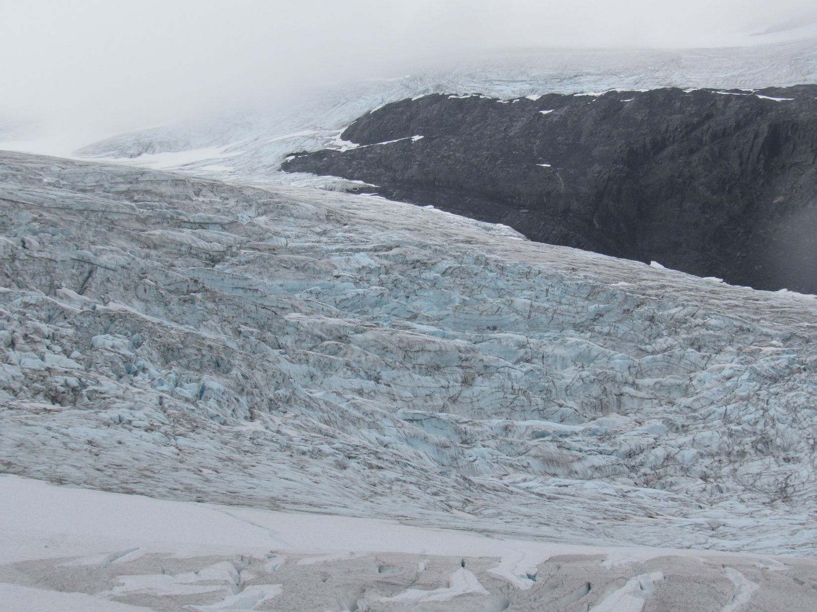
You might have to settle for just seeing Shoup Bay.  I’ve read that the glacier has retreated a mile and a half in recent times.  The topo map (scroll WSW) shows Shoup Glacier might have retreated around a corner we can’t get to.  This trail might not go far enough now to even see it.

Oh!  That would be disappointing.  Makes this an even bigger adventure than I thought, though.  Promise me one thing, SPHP!  Let’s keep going as far as we can, even past the end of the trail, if necessary.  I’d really like to see the glacier.  Maybe we can get all the way to it!

That’s the spirit, Loopster!  And the plan, too!  Shoup Glacier or bust!

Approaching the Gold Creek delta (Center). The S end of Shoup Bay is beyond the more distant partly forested ridge (R).

As Lupe drew near a yellow delta jutting S out into Port Valdez, the trail began to drop toward it.  She was almost all the way back down to sea level, in an absolute jungle, by the time she reached a junction.

Truly scenic! You do pick some fine trails, SPHP!
At Jungle Junction. Yes, another trail does go off to the R behind that fern.

Again, no sign.  The trail to the L had to go to the yellow delta, so Lupe tried it first.  The American Dingo soon passed a bank of metal bear-proof storage lockers.  Dinosaur-proof lockers would have seemed even more appropriate in this ferny wilderness.

Try to stay alert, SPHP! This is Allosaurus territory!

Looper kept going and came to a lone tent tucked beneath ancient pines.  Instead of glittering brightly, nearby Gold Creek was a disappointing milky gray.  Even so, this was still a gorgeous campsite, and it turned out that Gold Creek was chock full of salmon!

The secluded campsite near Gold Creek.
A Zen moment along Gold Creek.

At first, no one seemed to be around, but beyond the pines two women were examining rocks along Gold Creek.  SPHP chatted briefly with them, while Loop sniffed about roaming the Gold Creek delta.

Exploring the Gold Creek delta. Photo looks SW.

Turned out that the women had arrived just yesterday evening.  Their original intention had been to press on to Shoup Bay and the kittiwake rookery this morning, but they’d changed their minds.  They didn’t say why, but Gold Creek was a gorgeous spot.

As lovely as the Gold Creek delta was, Lupe couldn’t dawdle.  Gold Creek was only 3.25 miles from the trailhead.  The end of the Shoup Bay trail was still more than 6 miles away.  Once again, the Carolina Dog plunged back into the jungle.  At the junction beyond the bear-proof lockers, she now took the trail heading W.

It wasn’t far from Jungle Junction to a big metal bridge over Gold Creek.

Crossing Gold Creek.
Wow, this is quite a bridge! You coming, SPHP?

The big metal bridge was impressive, but at times Gold Creek must be equally so.  The bank the trail approached from had been completely washed away, leaving a gap between the trail and the bridge.  Four logs were positioned to bridge this gap.

Don’t be a klutz! You can do it, SPHP!
A look back from the far end.

After crossing the bridge, Lupe hopped up on a mossy stump that had been cut to produce a Dingo-sized chair.

On the Gold Creek bridge stump chair.

The trail ahead looked encouraging – no bushes and easy to follow!  Beyond Gold Creek, the American Dingo made rapid progress.  Slowly gaining elevation again, Looper trotted W amid ferns in a pine forest.

Beautiful, and so much easier than the bushes!

Lupe’s great progress didn’t last.  The Shoup Bay trail soon leveled out.  Emerging from the forest, the trail entered a region thick with bushes.

As soon as the trail left the forest, the bushes were incredible!

Although she couldn’t see a thing, the Carolina Dog kept going.  Shortly after the trail started downhill, SPHP called a halt.

Loopster, you there?

Of course!  What’s up?

Is there a trail down there?

Yes, you’re on it!  I’m in a green tunnel again.

I thought so.  I can sort of feel the trail with my feet, but there’s no trail up here.  I’m up to my neck in bushes, and can scarcely push through them.

Sounds like lopper time to me!  Good thing you brought ’em along!

Uh, yeah!  You’re a riot, Sweet Dingo!

I am?  Why?  What’s wrong, SPHP?

A few days and a giant machete might do it, Loop, but these loppers are useless – a cruel joke!  I’d need a month of Sundays to clip a way through this jungle.  Nothing but bushes as tall as I am as far as I can see!

Well, get down here then!  We’ll take the tunnel!

Crazy Dingo!  We’re barely 15 minutes beyond Gold Creek.  I’m not going to crawl for 6 miles with neither of us able to see where we’re going!  It’s not worth it!

You don’t want to see the kittiwake rookery and the Shoup Glacier?

Of course, I do!  But not this bad!  Face it, this trail exists only in the over-active imaginations of Valdez tourist guide authors.  I mean, look around you.  Other than your little green tunnel, do you see any sign that anyone else has come this way?  Small wonder they don’t know what conditions are like on this part of the trail back at the visitor center.  No one’s been this way in months, maybe years!  We need one of your Allosaurs to come stomp a route through this mess.

Allosaurs are no laughing matter, SPHP!  If you don’t want to bother with the loppers, and simply want to turn around, fine!  We can just forget this whole thing – kittiwakes, glaciers, and all!  Just don’t jinx us by tempting fate with Allosaurs!

The invisible Shoup Bay trail ahead. Photo looks SSW.
Hiding out from Allosaurs down in the green tunnel.
Looking E back over the Gold Creek delta.

And that was that.  Lupe’s Shoup Bay adventure was over without ever even having gotten halfway to Shoup Bay.  Destined to fail, the Carolina Dog never did see the kittiwake rookery or the Shoup Glacier.

On the way back, just before reaching the Gold Creek bridge, a faint side trail led N.  Hearing a roar in the same direction, Lupe followed this path intent upon discovering the source.  Nope, not an Allosaurus.  Only a couple minutes off the main trail, a lovely waterfall gushed from a rocky mountainside into a pool where lucky Gold Creek salmon must spawn less than 0.25 mile from the sea.  Definitely worth seeing!

Gold Creek falls.

8-21-19, 2:33 PM, 73ºF – It was over.  Back at the Shoup Bay trailhead, SPHP returned the sturdy, yet completely inadequate loppers.  Sunny and warm in Valdez, but even hazier than before.  Odd.  Humidity?  Pollution?

By 5:00 PM, Lupe was on the Richardson Highway on her way out of town.  Hours later, the Carolina Dog snoozed peacefully on her pink blankie while the G6 rolled W on the Glenn Highway.  A pink-orange sun sank into the murk.  As the dim outline of Gunsight Mountain (6,441 ft.) came into view, SPHP finally figured it out.

Smoke!  Alaska was on fire!

At Gold Creek falls, Shoup Bay trail, Valdez, Alaska 8-21-19.

Links:

Next Adventure                       Prior Adventure

The Worthington Glacier, Alaska (8-11-16)

Shoup Bay State Marine Park

Want more Lupe adventures?  Choose from Lupe’s 2019 Dingo Vacation to the Yukon & Alaska Adventure IndexDingo Vacations Adventure Index or Master Adventure Index.  Or subscribe free to new Lupe adventures.

The Worthington Glacier, Alaska (8-11-16)

Days 12 & 13 of Lupe’s Summer of 2016 Dingo Vacation to the Canadian Rockies, Yukon & Alaska.

Lupe’s adventures in the Yukon were done for now.  Only yesterday, she’d enjoyed an epic day climbing Mount Decoeli (7,650 ft.) in Kluane National Park.  From afar, she had seen Canada’s highest mountain, Mount Logan (19,541 ft.).  Today was going to be a well-deserved day of rest for the Carolina Dog.  Lupe would spend much of it snoozing in the G6, while SPHP drove N.

Lupe was on her way to Alaska!

Lupe's morning on 8-10-16 started near Kluane Lake in Kluane National Park in the Yukon. Mount Decoeli, which Lupe had climbed the day before, is seen here on the far (L) across Kluane Lake. Photo looks SE.
Lupe’s morning on 8-10-16 started near Kluane Lake in Kluane National Park in the Yukon. Mount Decoeli, which Lupe had climbed the day before, is seen here on the far (L) across Kluane Lake. Photo looks SE.
 Lupe at Kluane Lake in the Yukon. Photo looks SSE.
Lupe at Kluane Lake in the Yukon. Photo looks SSE.

Lupe and SPHP made frequent stops along the way.  Sometimes Lupe stopped at scenic highlights.  More often, SPHP was forced to stop due to road construction.  The Alaska Highway had buckled and heaved in many places.  Lupe & SPHP spent a good deal of time following pilot cars across dusty, torn-up, sections of road.  All the way, fascinating Yukon scenery was right outside the window of the G6.

Mountains of the Saint Elias range. Not a bad bit of scenery to enjoy while waiting for the pilot car to appear! Photo looks SW.

When Lupe crossed the mighty Donjek River, SPHP was stuck following a pilot car and couldn’t stop.  Farther N, she did get to stop and see the White River.

The vast floodplain of the White River. Photo looks downstream toward the NE.

The frost-heaved road, and all the construction made driving slow, but there was no real hurry.  By early afternoon, Lupe reached the border crossing from Canada into Alaska.  SPHP was disappointed when there was no colorful “Welcome to Alaska!” sign Lupe could pose by, only a dull, wordy, official sign at U.S. customs.  Oh well, at least there were no problems crossing the border.

Just being in Alaska was exciting!  Lupe had technically already been to a tiny piece of Alaska at Hyder on her way to see the Salmon Glacier, but now she was about to travel hundreds of miles across America’s largest, wildest, and most remote state.  The feeling was almost spine-tingling.  Who knew what adventures awaited Lupe in the Last Frontier State?

At Tok, Lupe left the Alaska Highway when SPHP turned S on the Tok Cut-off.  Near the SW end of the Tok Cut-off, Lupe got to see the Copper River from a high bluff.  If there hadn’t been so many clouds, Lupe might also have seen some of the giant snow and ice-capped peaks in Wrangell – St. Elias National Park & Preserve.

Lupe at the Copper River in Alaska. Photo looks W or SW in the downstream direction.
The Copper River from a pullout along the Tok Cut-off. Clouds prevented Lupe from seeing giant snow-capped peaks to the S in Wrangell - St. Elias National Park & Preserve. Photo looks upstream.
The Copper River from a pullout along the Tok Cut-off. Clouds prevented Lupe from seeing giant snow-capped peaks to the S in Wrangell – St. Elias National Park & Preserve. Photo looks upstream.

Near Gulkana, Lupe reached the Richardson Highway (No. 4).  SPHP took it going S toward Valdez.  By late evening, Lupe was approaching the Worthington Glacier.  It was an impressive sight, even from the highway!

Upper reaches of the Worthington Glacier as seen from the Richardson Highway. Photo looks WSW.
Worthington Glacier. Photo looks WSW using the telephoto lens.

Lupe’s long day of rest traveling through the Yukon into Alaska was almost over.  Tomorrow she would have several options, among them the Worthington Glacier Ridge Trail.  Where she would go would be decided tomorrow morning.  Until then, Lupe and SPHP settled in for the night.

The next morning did not bring good news.  The sky was socked in with low clouds.  A light mist was falling.  Conditions did not seem conducive to a hike near the Worthington Glacier.  SPHP drove over Thompson Pass toward Valdez.  In Keystone Canyon, many amazing, beautiful waterfalls tumbled down the mountainsides.  Lupe stopped briefly for a closer look at Bridal Veil Falls and Horsetail Falls.

Bridal Veil Falls in Keystone Canyon.
Lupe at Horsetail Falls.
Lupe at the base of Horsetail Falls. Both Bridal Veil Falls and Horsetail Falls can be viewed from pullouts along the Richardson Highway in Keystone Canyon on the way to Valdez. They are no more than 0.5 mile apart, but on opposite sides of the highway.

By the time Lupe reached Valdez, it was raining harder.  The rain wasn’t heavy, but it was steady.  With the rain falling, there wasn’t any urgency to do anything outdoors.  SPHP dropped by the local Safeway store, and bought a roasted chicken to share with Lupe.  Oddly, she wasn’t hungry.  She refused any chicken.  That seemed strange, but OK.  Lupe and SPHP watched the rain fall, while SPHP consumed part of the chicken.

It was soon apparent why Lupe didn’t want any chicken.  Without warning, she threw up.  Poor, Loopster wasn’t feeling well!  SPHP cleaned up her soiled blanket, then took Lupe out for a short walk in the rain to let her get anything else bad out of her system.  She seemed to feel better.

There were a couple of awesome adventures near Valdez that SPHP was hoping Lupe might be able to do.  One was to take the trail to Shoup Bay to see the Shoup Glacier and Kittiwake rookery.  To do the whole trail was a long day hike, but maybe Lupe could do it tomorrow, if the weather cleared up.

The other adventure had been suggested by Richard Baker, whom Lupe had met on Mount Decoeli in the Yukon.  Richard had highly recommended taking a cruise on Prince William Sound aboard the Lu-Lu Belle to see the Columbia Glacier, the second largest tidewater glacier in North America.  Whales, eagles and other wildlife are sometimes seen from the Lu-Lu Belle, too.

Lupe had to wait in the G6, while SPHP went into the Lu-Lu Belle office to inquire about the Columbia Glacier tour.  The receptionist was very courteous and friendly.  She said the Lu-Lu Belle goes to the Columbia Glacier every day in season, pretty much regardless of the weather.  The cost was $125 per person for an approximately 7 hour long tour aboard the luxury yacht.

It all sounded wonderful!  Time for the big question.  What about Lupe?  Bad news.  Lupe couldn’t go.  They had dog-sitting services available, but the tour was a no-go for poor Looper.

No doubt it would have been a fantastic excursion, but if Lupe wasn’t going on the Lu-Lu Belle, neither was SPHP.  This isn’t The (Mostly) True Adventures of SPHP, you know!  So that was that, but before leaving the Lu-Lu Belle office, SPHP asked about the weather forecast.

The receptionist looked up the Valdez forecast on her computer.  100% chance of rain today and each of the next four days, then dropping to only 80%, 70%, and 40% for the three following days.  She then said it had already been raining in Valdez for 3 straight weeks.

Yikes!  That changed everything.  Lupe and SPHP were willing to wait out a day or two of poor weather, but sitting around for more than a whole week of rain made no sense.  SPHP returned to Lupe with the glum news.  No Lu-Lu Belle, no Shoup Glacier, no Worthington Glacier.  What to do?

If the Alaskan coast was going to be socked in with rain for another week or more, the only thing SPHP could think of doing was to head back inland.  It meant Lupe wouldn’t get to do any of the cool stuff near Valdez on this trip, but Alaska is a huge place.  There were other adventures in store for Lupe elsewhere.

Unfortunately, there was no point in hanging around Valdez.  Amid rain and mist, Lupe and SPHP left town to start the long drive inland again on the Richardson Highway.  Once again, Lupe traveled along the Lowe River, up Keystone Canyon, past Horsetail, Bridal Veil, and lots of other gorgeous waterfalls.  She crossed Thompson Pass, and took a last glance at the Worthington Glacier as SPHP drove on by.

Wait a minute!  The sky was still completely overcast, but only the tops of the mountains were in the clouds.  The Worthington Glacier was in view.  It was barely misting here.  SPHP turned the G6 around.  Lupe was going to get to see the Worthington Glacier after all!  If the rain would hold off for only a few hours, a little mist wouldn’t stop an American Dingo!

SPHP drove back to the Worthington Glacier State Recreation Site.  A dozen other vehicles were in the parking lot.  People were coming and going.  Nearly all of them were taking the short nature trail down to a viewpoint where the toe of the glacier could be seen.  Nice, but not what Lupe had come for.

Lupe was here to take the much longer Worthington Glacier Ridge Trail, which goes W for a mile and a half, or more, on a ridge S of the glacier.  Lupe and SPHP could see a couple hikers coming down the ridge trail.  When they got to the start of the trail at the parking lot, SPHP talked to them.  How were conditions up on the ridge?  How far had they gone?  Was anyone else up there right now?

Conditions were cloudy, a bit damp and rainy at times.  They had made it all the way to what they considered the end of the trail.  The glacier views were spectacular.  Not another soul was up on the trail now.  They were the last ones down.

Wonderful, that settled it!  Lupe and SPHP started up the ridge.

Lupe starts up the Worthington Glacier Ridge Trail. Photo looks W.

The Worthington Glacier Ridge Trail began climbing along the top of a very narrow ridge with steep sides.  To the S (L) was a very green valley of mixed alder and tundra.  To the N (R) was the valley the Worthington Glacier flows down.  The trail followed the ridgeline W.  As Lupe gained elevation, the views of the Worthington Glacier up ahead became progressively more impressive.

The very green mixed alder and tundra valley on the S (L) side of the trail is shown well here. Part of the trail leaves the ridge near unstable cliffs to travel safely through this valley a little way before returning to the ridge. Lupe loved the green valley, but there were mosquitoes down there. They weren't too bad. Up on the ridge, a breeze blew them away. Photo looks W.
The very green mixed alder and tundra valley on the S (L) side of the trail is shown well here. Part of the trail leaves the ridge near unstable cliffs to travel safely through this valley a little way before returning to the ridge. Lupe loved the green valley, but there were mosquitoes down there. They weren’t too bad. Up on the ridge, a breeze blew them away. Photo looks W.
As Lupe climbed, the views of the Worthington Glacier steadily improved. The big rounded hump seen ahead on the L looked like it might be the end of the trail. Photo looks WNW.
The Worthington Glacier has two arms, separated by the ridge of rock seen on the upper R. Near the lower end of the glacier, both arms drop steeply as seen here. A little farther up, the glacier is one big river of ice. Photo looks NW.
Gotta love that beautiful blue glacier ice!

The ridge trail left the ridge temporarily to bypass dangerous cliffs.  It entered the green valley of mixed alders and tundra.  There were a few mosquitoes down here to deal with, but they weren’t too bad.  They were pretty much limited to the valley on this day.  A breeze kept them from being much of a bother up on the ridge.

Lupe loved the green valley!  SPHP thought it was great, too.  The valley was full of wildflowers.  The tiny, delicate plants growing on the tundra were fascinating.  They were so incredibly varied and colorful!

Bright wildflowers in the lush green valley S of the ridge.
For Lupe, the beautiful green valley was one of her favorite parts of the whole Worthington Glacier Ridge Trail. The glacier isn't in view here, but it can be seen from virtually everywhere else on the ridge trail. Lupe was completely convinced the wildflowers and tundra were worth seeing, too! Photo looks E.
For Lupe, the beautiful green valley was one of her favorite parts of the whole Worthington Glacier Ridge Trail. The glacier isn’t in view here, but it can be seen from virtually everywhere else on the ridge trail. Lupe was completely convinced the wildflowers and tundra were worth seeing, too! Photo looks E.
Delicate, vibrant little plants of the tundra. They were only an inch or two high.

Before long, the trail left Lupe’s lush, green valley and returned to the ridge.  The Worthington Glacier was always in view from here on.  The trail headed up toward a high, barren, rounded mound of dark colored soil and rock.  It looked like that hill might be the end of the trail.  The climb up to the top was steep!

Back on the ridge again, the Worthington Glacier was always in view.
Lovely blue crevasses as seen with a little help from the telephoto lens.
As Lupe climbed the last high, barren, rounded hill, she had this view of the Worthington Glacier as a single river of ice above where the glacier split in two. Photo looks WNW.
Near the top of the last high, barren, rounded hill. From below, this hill looked like it might be the end of the trail. Maybe it is the end of the formal trail, but Lupe found out it was possible to go quite a long way farther. Cairns showed the way. Photo looks W.

Lupe reached the top of the high, barren, rounded hill.  The trail leveled out and went right on over it.  At first, SPHP wasn’t certain if the trail continued or not.  Lupe and SPHP left the ridgeline to explore farther W along the N side of a mountain.  Others had been this way, too.  The terrain was rocky and uneven.  There was no longer a distinct, continuous trail, but now and then Lupe came to cairns along the way.

Part of the time, Lupe was traveling over relatively level, wide, rock shelves.  Other times, she had to climb steep slopes.  Lupe passed by occasional bright patches of wildflowers.  Some places bright green moss clung to dark rocks next to trickling waterfalls.  To the S was the mountain.  To the N, Lupe looked down upon the Worthington Glacier.  And to the W, Lupe’s route rose toward a white, gray and black world of clouds, snow, ice, and dark earth.

As Lupe explored farther W above the Worthington Glacier, she sometimes came to colorful patches of wildflowers in an otherwise bleak world. Photo looks WNW.
Wildflowers bring a splash of color to the Worthington Glacier.
A mighty American Dingo explores the harsh environment of the Worthington Glacier! Actually, the worst Lupe had to face was some light rain and heavy mist that came and went. The temperature wasn't that bad, either - maybe in the upper 40's °F. Photo looks WNW.
A mighty American Dingo explores the harsh environment of the Worthington Glacier! Actually, the worst Lupe had to face was some light rain and heavy mist that came and went. The temperature wasn’t that bad, either – maybe in the upper 40’s °F. Photo looks WNW.
A glacial tsunami surges over the lip of a vast bowl of snow and ice above. Lupe had seen what was higher up from the Richardson Highway yesterday evening, but the upper part of the glacier wasn't visible now. Photo looks WNW.
A glacial tsunami surges over the lip of a vast bowl of snow and ice above. Lupe had seen what was higher up from the Richardson Highway yesterday evening, but the upper part of the glacier wasn’t visible now. Photo looks WNW.
A really big cairn beckons, showing the way ahead. Photo looks W.
Lupe reaches the really big cairn. She kept going for a considerable distance from here. Smaller cairns continued to confirm her route. Photo looks NW.

Lupe at the Worthington Glacier, Alaska 8-11-16After traveling a considerable distance along the mountainside, Lupe reached a really big cairn at a high point.  SPHP thought maybe the big cairn meant Lupe was getting close to the end of how far she was going to be able to go W.

This wasn’t the end yet, though.  Onward!  The slope of the terrain lessened.  Lupe still had to climb some, but gained elevation more slowly than before.  The bold, damp Carolina Dog went on and on.  Small cairns marked the route.  The farther Lupe went, the more streams of rain and meltwater she encountered pouring over the rocks.

At last, it could be seen that Lupe was nearing a point where she would be surrounded by snow and ice on 3 sides.

Through light rain and mist, Lupe presses on toward the end. Soon she would be surrounded by snow and ice on 3 sides. Photo looks W.

Lupe reached the end of how far she could go W.  The view was stupendous, even on a cloudy, drizzly day.  Beneath the misty clouds, the sense of grandeur, solitude, and isolation was supreme.  Snow, ice, mist, and dark rocks comprised the whole visible world.

To the SW, a big patch of pink snow was close at hand.  SPHP was chilly enough, but the hot-blooded Carolina Dog thought a frolic on the snow would be fun!

A hot-blooded Carolina Dog frolics on a patch of pink snow at the end of the line. The glacier, no doubt, melted a little more from this abuse.
Lupe at the end of the line. She was surrounded on 3 sides by snow and ice. Photo looks WSW.
Looking back down the Worthington Glacier from close to the W end of Lupe's advance. The Richardson Highway is seen far below. Photo looks ENE.
Looking back down the Worthington Glacier from close to the W end of Lupe’s advance. The Richardson Highway is seen far below. Photo looks ENE.
Lupe at the end of the line. The Worthington Glacier flows down from higher still, but this was as far as Lupe could go. Photo looks NW.

After the Carolina Dog had cooled down sufficiently, Lupe and SPHP stood at the final high point Lupe reached, contemplating the Worthington Glacier and enjoying this rare, exquisite moment.

As SPHP looked around, it looked like Lupe might be able to go back to the SE, and climb 200 feet higher on the mountainside above.  Any higher up than that, the mountain was buried beneath deep, pristine snow.  Lupe might have seen more from up on the mountainside, but SPHP decided against it.

On a clear, bright day, the additional climb would have been worth it, but everything was wet and slippery now.  A cold, light rain was falling.  Even if Lupe had climbed higher, clouds and fog might easily have negated any benefit.  In truth, Lupe was lucky the weather had cooperated enough to let her get this far.  She’d had an unexpectedly wonderful day.

Lupe and SPHP stayed for a while at the far W end of Lupe's advance contemplating this slow-moving river of ancient ice and snow known as the Worthington Glacier. Photo looks NW.
Lupe and SPHP stayed for a while at the far W end of Lupe’s advance contemplating this slow-moving river of ancient ice and snow known as the Worthington Glacier. Photo looks NW.
Lupe thinking deep thoughts at the end of the line – There hasn’t been a squirrel here in 25,000 years!
Looking NE.
Looking NE.
Lupe stands near the small cairn at the end of her Worthington Glacier exploration. Photo looks NE.

There was only one way back, which was to retrace Lupe’s entire route up here.  Of course, going in the reverse direction provided a different perspective.  One thing didn’t change.  Lupe continued sniffing and exploring.  Even SPHP stopped to examine a few details along the way.

Bright green moss grew near trickling waterfalls.

Moss near the Worthington Glacier, Alaska 8-11-16

The really big cairn is seen ahead, this time to the E.
Lupe explores near a patch of wildflowers. At least there was something worth sniffing! Photo looks E.
Don't jump, Loop! You forgot your SUPER DINGO cape!
Don’t jump, Loop! You forgot your SUPER DINGO cape!
Looking NE. The weather wasn't really improving on the return trip.
Looking NE. The weather wasn’t really improving on the return trip.
Lupe back on the Worthington Glacier Ridge Trail on top of the high, barren hill. Photo looks ENE.
Uh, Lupe did mention that the route up the high, barren, rounded hill was sort of steep, didn't she? Photo looks E.
Uh, Lupe did mention that the route up the high, barren, rounded hill was sort of steep, didn’t she? Photo looks E.
What makes that glacial blue so appealing, anyway?

Four or five hours after she’d left, Lupe was back at the G6.  Her adventure on the Worthington Glacier Ridge Trail had been a very worthwhile success!  SPHP was so glad she’d done it!

The long trek had cured any remaining queasiness from earlier in the day.  Lupe was famished!  She made up for having missed breakfast by doing more than her fair share helping SPHP devour every last bit of the leftover roasted chicken.  Once full of chicken, Lupe felt a tad sleepy.

Full of roasted chicken, Lupe passed out in the G6.

Digesting all that chicken took awhile.  Lupe had a nice long Dingo nap.  By the time she woke up, it was evening.  There was still time, though, to take the short nature trail to the viewpoint looking up at the S toe of the Worthington Glacier from below.

The trail to the viewpoint took only a few minutes.  There were, however, unofficial trails that people had made going closer to the glacier.  Naturally, Lupe and SPHP thought it a good idea to go find out what could be seen along them.

The unofficial trails were wet, muddy and slick.  They climbed an incredible jumble of rocks.  The terrain looked like an explosion had taken place.  Of course, there hadn’t been any explosion.  The rocks were just as they had been unceremoniously dumped at the not-too-long-ago terminal moraine of the Worthington Glacier.

Among the rocky debris left by the retreat of the Worthington Glacier. Photo looks W.
Lupe got close enough to see the toe of the glacier. Photo looks W.
Near the toe. Photo looks W.
S toe of the Worthington Glacier in Alaska.

After scrambling over the jumble of rock close enough to get a good look at the S toe of the glacier, there was one more thing to go see.  Earlier, on the way back to the G6, while Lupe was still way up high on the ridge trail, SPHP had noticed a very long stream of water cascading down the lower N side of the Worthington Glacier valley.

From above, the stream of water had presented a rather bizarre optical illusion.  It looked like the water cascaded up and over a ridge of solid rock!  Simply impossible, but that was how it had looked to SPHP.  Lupe wasn’t far now from the bottom of that stream.  Time to go take a closer look!

Lupe at the bottom of the anti-gravity waterfall. Everything was normal, the water fell down, not up. Photo looks N.

When Lupe got to the base of the falls, everything was normal.  The water fell down, not up.  Which is how it should be, and always will be.  The mystery wasn’t completely solved for SPHP, because the part of the long stream that had seemed to cascade uphill was out of sight much higher up.  Illusion that it no doubt was, this stream had earned the nickname “Anti-gravity Creek” as far as SPHP was concerned.

It had been quite a day at the Worthington Glacier for Loopster, but it was getting dark.  The rain was starting up again.  Almost back at the G6, SPHP thought of one more thing Lupe might want to check out.  When SPHP turned and headed toward the glacier once more, Lupe let out a single, no-nonsense woof!

She’d had enough!  Time to dry off and get some shut-eye!  Meekly, SPHP obeyed.  Back to the G6.  Sometimes Dingoes know best!

SPHP, you might want to have your eyes checked! Water falls down, got that? Down!

Links:

Next Adventure                                Prior Adventure

Want more Lupe adventures?  Choose from Lupe’s 2016 Canadian Rockies, Yukon & Alaska Adventure Index, Dingo Vacations Adventure Index or Master Adventure Index.  Or subscribe free to new Lupe adventures.