Abercrombie Mountain, Selkirk Mountains, Washington (8-11-21)

Day 6 of Lupe’s 3rd Summer of 2021 Dingo Vacation to the West Coast!
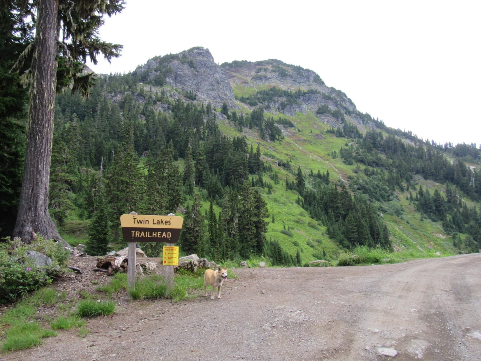
9:42 AM, Hwy 508, far NW Montana

Hey, Loop!  Yaak Falls is coming up!  Any interest in sniffing the air, and having a peek at it?

Sure, SPHP!  Let’s do it!

And why not?  This was probably going to be just a rest and positioning day, anyway.  Bit of a drive to Abercrombie Mountain (7,308 ft.) in NE Washington from here.  With the sky looking as smoky as it was this morning, didn’t look like Lupe needed to be in any big rush to get there.

Yaak Falls was practically right along the highway.  SPHP parked the RAV4 at a pullout, and Lupe sniffed her way over to the river for a look at the falls.  Drought conditions appeared to have the Yaak River running very low, even for August.

The Yaak River on a smoky August morning. Photo looks N.
Yaak Falls.
A better angle.

Very nice, SPHP!   Bet Yaak Falls is a lot more impressive in the spring, though.

Heh.  Doesn’t seem to be much doubt about that, does there?  Probably many times the flow we see here today.

Yaak Falls was the last stop in Montana.  The American Dingo was soon cruising in air-conditioned comfort through the Idaho panhandle.  An otherwise scenic drive was marred by the discouraging amount of smoke in the air.  Loopster might have to skip Abercrombie Mountain entirely.

The drive W was mighty inefficient, since the highways kept making big swings N and S.  By the time Lupe was in NE Washington, she was ready for another waterfall.  SPHP stopped at Crystal Falls on the Little Pend Oreille River, but only a rather restricted view of it was available.

Crystal Falls.

Entering Colville from the E on Hwy 20, SPHP spotted Aladdin Road on the R.  That was the way to the W approach to Abercrombie Mountain, which was still many miles NNE.  A quick stop for supplies in Colville, and Lupe was on her way!  Road construction close to town caused a few delays, but eventually the RAV4 was bouncing along USFS Road No. 300, which was soft, and a bit rough, after having been recently churned up while graded.

Glad we’ve got the RAV4, Loop!  Not sure the trusty old G6 would have made it!

Oh, ye of little faith!  Don’t be dissing the G6 now, SPHP!  Got us to the Arctic Ocean twice, and Alaska 4 times!  The G6 could have done this.

Come on, Looper!  You know I would never disparage the G6!  Even so, a little better clearance sure improves confidence.

Still quite narrow, but No. 300 had improved a great deal by the time a very encouraging sign appeared.  Abercrombie trailhead!  Right around the next bend, No. 300 dead-ended at a small, vacant parking area.

Hah!  Made it!  You’re golden now, Loopster!

The sign of success!
Parked at the Abercrombie trailhead.

3:48 PM, 79ºF, Abercrombie trailhead –  Plenty warm out, but definitely cooler up here at the trailhead than it had been during the drive through Idaho into Washington.  Overhead, despite some smoky haziness, the cloudless sky looked surprisingly blue.

What do you think, Looper?  I’d been expecting on the way over that it was going to be too smoky to climb Abercrombie Mountain (7,308 ft.) today, and that we’d just have to hope for the best in the morning.  Really doesn’t look all that bad right now, though.  Want to try it?

Do we have time, SPHP?  How far is it?

Less than 4 miles one way, I believe. Under 2,400 feet of elevation gain, with what’s supposed to be a decent trail all the way.

Shoot, we can do that, SPHP!  Why wait and take a chance on what the smoke will be like tomorrow?  Should cool off some more as the sun sinks, too.  Might be a pretty pleasant evening on Abercrombie Mountain!

For better or worse, Abercrombie Mountain was a go!  A wooden box next to the start of Trail No. 117 contained registration forms, but they were all old and already used.

Guess we can skip this step, Loop.  Doesn’t look like anyone cares.

American Dingoes don’t care for paperwork, that was for sure.  Not their strong suit, nor SPHP’s for that matter, either.

Onward!  Puppy, ho!

Start of Trail No. 117 to Abercrombie Mountain.

Trail No. 117 was good – smooth and easy to follow, with few rocks or roots.  Lupe trotted gradually higher on a series of long switchbacks that snaked through a jungley forest full of ferns and big-leafed plants.  10 minutes from the trailhead, she got a drink from a small stream.

On the easy path higher.
Crossing the shallow stream.

This same stream crossed the trail a couple more times higher up.  Last time Loop came to it, the stream was reduced to a mere mossy trickle.  The switchbacks went on and on, steepening and getting tighter as they worked up the side of a big ridge.  Nothing to see, really.  Dense forest hid whatever views there might have been.

Amid the ferny jungle.
By the mossy remnant of the stream.

Definitely a tougher climb toward the end, but Trail No. 117 never did get all that steep before finally starting to level out up on the big ridge.  Lupe had gained more than 800 feet of elevation by now, at least a third of what she needed to do.  No ferns or big-leafed plants up here, but the forest was otherwise unchanged.

Heading S across the ridge at a saddle just E of HP5985, Loop came to a 3-way intersection.  An old sign was only partially legible.  Trail No. 119 came up from the North Fork of Silver Creek here, a starting point to the SW nearly 2,000 feet lower than the Abercrombie trailhead.

At the junction with Trail No. 119. Photo looks S.

How about a short break, Looper?  Want to split a chocolate coconut bar?

Panting while laying in the shade, the Carolina Dog showed no interest in the chocolate coconut bar.  SPHP ate the whole thing.  How often did that happen?

Are you OK, Loop?  You aren’t getting sick, are you?

I’m fine.  Just hot, that’s all, SPHP.

Well, here.  Have some water, then.

Sticking with Trail No. 117, Lupe left the junction going ENE.  A mere 50 feet brought her to a tree bearing a marker.

By the tree with the trail marker. Photo looks ENE.

Hey!  Guess what, Loop?  This is a PNT marker!

We’re on the Pacific Northwest Trail again, SPHP?  We could have taken the PNT all the way from Northwest Peak to Abercrombie Mountain?

Heh.  Yeah, if we weren’t interested in doing much of anything else on this Dingo Vacation.  Probably could have been here by September!

The trail was almost flat.  Lupe gained only a little elevation as it curved around the N side of a minor hill along the ridgeline.  Once beyond the hill, No. 117 swung S, dipping 20 feet down into a ravine before starting up again.

Heading down into the ravine. Photo looks S.

Climbing steadily now, No. 117 began switchbacking higher with long runs SE interrupted by shorter ones N.  Soon the trail seemed sunnier.

The forest is thinning out, SPHP!  Maybe we’re finally going to get to see something?

Getting sunnier as the trail climbs more steeply. Photo looks SSE.

Sure enough!  At the end of one of the first long runs SE, Lupe reached a meadow.  There was a big view to the S.

Not good.

A lot smokier now. Photo looks S.

Gone were the blue skies that had prevailed when the American Dingo set out from the trailhead.  A smokey haze, brought in by a breeze that had sprung up, filled the air.  Still sort of blue to the E, but the air quality was much worse, an opaque white, off to the W where the breeze was coming from.

Criminitly, Loop!  We better pick up the pace, or we aren’t going to be able to see a thing from Abercrombie Mountain!

Trail No. 117 turned N back into the forest.  More switchbacks.  Same pattern.  Long runs SE interspersed with shorter ones N.  The hillside steepened, but the trail wasn’t bad at all.  The forest continued to thin.  All views told the same story.  Better keep at it, if Lupe hoped to have any possibility of a view from the top.

Heading SE.
Going N.

The switchbacks ended shortly before reaching Abercrombie Mountain’s S ridge.  The broad, rounded ridge sported only scattered stands of live forest.  Gnarled skeleton trees, bleached white by the sun, stood forlorn and alone whispering of days long past, dead companions collapsed here and there about them.

Too late!  Air quality was getting worse.  Blasted breeze!  Why couldn’t it have held off for an hour or two?  Would have made all the difference.

Finally up on the S ridge. HP6631 (R). Photo looks S.

0.5 mile away and 600 feet higher, the summit was now visible almost due N.  Hurrying on, Trail No. 117 dipped over to the E side of the ridge before heading straight for it.

Abercrombie Mountain summit (Center). Photo looks N.

Up the rest of the way, a relatively easy trudge higher as mountains go.  Naturally, it got steeper toward the end.  Lupe roamed the meadows at will, enjoying this landscape with it’s mixture of trees and open ground.

An easy trudge higher. Summit (Center). Photo looks N.
Making progress. Photo looks NNW.

Lupe was already very high, getting close to the end, when Trail No. 117 went right past an incredibly gnarled Ent at the base of a hill where the mountain finally became rocky.  Immediately beyond this first hill was a larger and even rockier one.

Near the Ent (L) guarding access to the summit region. Photo looks N.
On the rocky path to the summit plateau. Photo looks N.

At the top of the second hill, Lupe reached the S end of a summit plateau that sloped higher to the N.  Somewhat surprisingly, the plateau wasn’t all rock, but featured grassy areas and even a few stunted trees.  As Loop headed for the summit at the N end, she passed assorted human-made rock walls, remnants of the foundation of a now absent lookout, and even a Dingo fort.

Sweet!  Hang on, SPHP.  Gotta check out this fort!

On the summit plateau. Dingo fort (L)! Photo looks N.
Checking out Fort Dingo.
Approaching the old fire lookout foundation. Photo looks N.

6:35 PM, 63ºF, Abercrombie Mountain (7,308 ft.) – Maybe should have waited until tomorrow, after all?  Visibility was poor when Lupe reached the true summit at the N end of Abercrombie’s summit plateau.  An hour earlier that might not have been the case.  Disappointing.

In the odd, diffused light of a sun soon sinking into the murk, Lupe stood on what appeared to be Abercrombie Mountain’s natural highpoint.  Hard to say if these rocks really were undisturbed, or not.  The highest rocks on the mountain were part of an artificially created rock wall.  Perhaps this mound had been rearranged, too?

Nearby, a brass survey benchmark was fastened to the top of a chunk of concrete.  Several rocks were stacked on top of a green metal box.

At the apparent true summit of Abercrombie Mountain. Photo looks ENE.
The battered brass survey benchmark.

Visibility wasn’t totally obscured.  Outlines of mountains and ridges could be seen through the haze.  Hooknose Mountain (7,210 ft.) 3 miles NE was about it, though, as far as being able to see any detail.  The W breeze was bringing even worse smoke this way, so even these views might vanish.  After a few quick photos in case that happened, SPHP opened the green box.

Hooknose Mountain (Center). Photo looks NE.
Abercrombie’s summit plateau from the true summit. Photo looks SSW.
Another look at Hooknose Mountain showing more of the territory leading to it. Photo looks NE.

Mostly trash inside.  Only one decent registry, a small one with a green cover that had been started in 2020.  It was already full of entries.  No room to add Lupe’s name.  A much larger registry was all chewed up by animals to the point where it was basically worthless.  SPHP shoved it into a sack along with rotten candy, sopping wet playing and business cards, empty plastic bottles, etc. for disposal later on, leaving only the green registry, pens, and pencils in a zip lock bag.

Mind if we take a break, SPHP?

Retreating back down to some stunted conifers along the W edge of the summit plateau, Lupe found a place with some greenery to relax.

Going to take it easy for a bit. Summit (R) beyond Lupe. Photo looks ENE.
Old lookout foundation (L). Back side of Fort Dingo (Center). Photo looks SSW.

Facing W toward HP6014, Loop and SPHP hung out together for a while watching the sun sink as horrid, thick smoke drifted in out of the NW.

HP6014 (L of Center) in the haze. Photo looks W.

Not even going to be any sunset, is there, SPHP?

Naw.  Too smoky!  At some point the sun will just vanish in the murk.

Are we still close to Canada?

Yup!  We should have been able to see Canada again from up here.  It’s less than 6 miles N.  Not going to happen tonight, though, Looper.

Being on Abercrombie Mountain, a super prominent peak with more than 5,000 feet of prominence, was still pretty cool, even if the views were basically shot.  Not too many supers around!  Intent upon staying up here for her traditional full summit hour, Lupe had time enough for another tour of the true summit region.  Might as well!

Near the true summit again. Photo looks N.
Looking SE. Survey benchmark (lower L).
By a cairn along the N edge. Photo looks W.
Hooknose Mountain (Center) again. Photo looks NE.

Well, getting to be about that time.  Rooting for a sunset, but knowing it wasn’t going to happen, Lupe and SPHP watched the golden orb turn red as it sank into the smoke.  Didn’t even get close to the horizon before, suddenly, it was gone.

Sunset, sort of, from Abercrombie Mountain.

A few minutes later, the Carolina Dog was gone, too.  With a great trail to follow, the descent was fun and went fast.

Starting down. Photo looks S.
By the ancient Ent again. Photo looks S.

Dusk came on even faster.  SPHP was forced to bring out the flashlight well before Loop made it back to the junction with Trail No. 119.  Soon there was movement in the gloom of the forest floor next to the trail.  Lupe got her first sniff ever of a big, fat mountain toad.

Mountain toad?  Even SPHP had never heard of such a thing!  But there it was, a real, live, ugly mountain toad hopping along in the underbrush.  Turned out it wasn’t the only one on Abercrombie Mountain, either.  Kind of creepy in the dark, but hardly dangerous.  (End, 9:18 PM, 65ºF)

You’ve got to be kidding me, right SPHP?  That’s it?  “Mountain toads – hardly dangerous.”  That’s how you’re going to end our tale of adventure about Abercrombie Mountain, a super prominent peak?

Well, what do you expect me to say, Loop?  Mountain toads seem unusual enough to deserve mention, but beyond that, they give me writer’s block.

Oh, I don’t know, SPHP, but snazz it up a bit!  How about something about the Attack of the Killer Mountain Toads!

Attack of the Killer Mountain Toads?  No one’s going to believe that, Looper!

Use your imagination, then, SPHP!  This is Washington state, right?  I know!  How about an amusing or scary tale about Big Wart!

Big Wart!  You mean like Big Foot, only, umm …

Yes!  Wartier!

Wartier!  That’s not even a word, Loopster.  I’m calling it.  Scintillating end or not, it’s just plain old, never-even-heard-of them-before mountain toads, and this is a wrap.

On Abercrombie Mountain, Selkirk Mountains, Washington 8-11-21

Links:

Next Adventure                     Prior Adventure

GPS track by Scott Rice (7-7-18)

Want more Lupe adventures?  Choose from Lupe’s Summer of 2021 Dingo Vacations to New Mexico, Wyoming & the West Coast Adventure Index, Dingo Vacations Adventure Index or Master Adventure Index.  Or subscribe free to new Lupe adventures.

Gold Mountain, the Kitsap County, Washington High Point (11-28-18)

Day 6 of Lupe’s 2018 Dingo Vacation to Washington State!

I might have known.

Known, what?  What’s wrong, SPHP?

Oh, nothing much, Looper.  Mountains of gold are notoriously difficult to find.  No doubt this is just par for the course.

You can’t find Gold Mountain?

Not exactly, not yet, but I’m certain we can’t be too far from it.

Well, maybe you should quit driving in circles and back and forth, and just follow the treasure map!

That was part of the problem.  SPHP had only printed out the portion of the treasure map that actually showed Gold Mountain (1,761 ft.) and a small area close to it.  Additional notes on what roads to take to get to the trailhead, and what SPHP could remember about their configuration, weren’t matching up with reality.  The topo map was old, as treasure maps are apt to be.  Apparently new roads had been built, and new names given to old roads.

Talk about confusing!  SPHP drove right past the Gold Creek trailhead thinking it couldn’t be the right place since the roads to it weren’t as shown on the ancient treasure map.  Half an hour plus of useless driving around later, Lupe was back.  Yeah, this was it!

The Gold Creek trailhead was huge.  Two different trails left it, just as Lupe’s friend mountaineer Jobe Wymore had said.

Lupe arrives at the entrance to the Gold Creek trailhead. Photo looks ESE.
The Gold Creek trailhead was huge, and practically empty. Photo looks SSW.

Only a couple of other vehicles were around when SPHP finally parked the CX3.  (12:18 PM, 47°F)  The low, gray sky promised a genuine Pacific Northwest experience.  Light rain fell as Lupe sniffed about the parking lot while SPHP tried to remember which trail to take.  A map posted at the trailhead showed a trail to Green Mountain (1,700 ft.), but none to Gold Mountain.  Hmm.

Yesterday evening, Jobe had been very specific about which trail to take.  It had all been so clear then, that SPHP hadn’t bothered writing it down.  Pure genius!  All SPHP could really remember was that the correct route started out going E or NE sort of in the direction of Gold Creek, but soon took a turn to the SE.  Actually following the creek was a no-no.

Well, how hard could it be?  Lupe only had two options.  The Gold Creek trail left the N end of the trailhead heading NE.  Hundreds of feet farther S, the Tin Mine trail went E.  Both trails immediately disappeared into the forest.

Not at all certain it was the right thing to do, SPHP let Lupe start up the Gold Creek trail.

Loopster at the start of the Gold Creek trail. Photo looks NE.

The Gold Creek trail was a wide, well-worn path.  It wound through a dense forest.  The dreary sky wept a steady rain.  Lupe came to many puddles and places where the trail itself was a small stream.

Exploring the Gold Creek trail.

SPHP watched for a turn to the SE, but Lupe didn’t come to one.  She had only been on the trail 10 minutes when the roar of Gold Creek could be heard to the N.  Peering through the forest, it was soon possible to see Gold Creek down in a big ravine.  Gold Creek was much larger than SPHP had imagined.

After 10 minutes on the trail, Gold Creek could be seen in a deep ravine to the N. Photo looks NE with help from the telephoto lens.

SPHP checked the treasure map.  The map showed a GPS track up Gold Mountain that never got this close to Gold Creek.  The Carolina Dog was going the wrong way.  Oh, well!  Lupe returned to the trailhead.

Of course, the intention was to check out the Tin Mine trail next.  Hah!  As soon as Looper reached the trailhead, she noticed what seemed to be a long abandoned road immediately S of the Gold Creek trail.  Cursory examination revealed an unmarked trail disappearing into the forest.  Could this be the right way?

Upon returning to the trailhead, Lupe stands on what appears to be an abandoned road disappearing into the forest. Photo looks ENE.

Probably not.  Jobe hadn’t mentioned any unmarked trails!  Still, it seemed worth a brief exploration.  SPHP followed Lupe into the forest.  Surprisingly, instead of fading away, the unmarked trail became better defined.  It headed E or ENE gaining some elevation.

On the unmarked trail. Photo looks E.

Within 5 minutes, Lupe came to a junction with a somewhat better trail coming in from the SW.  Perhaps this was the Tin Mine trail?  Maybe Lupe had taken a shortcut to it?  There were no signs here, either, but it at least seemed possible.  Loop continued ENE on the better trail.

The climb was steepening.  The trail began to bend around to the SE.  This was all exactly what was supposed to happen.  However, there were complications.  The forest was full of trails!  Lupe kept coming to forks going in all sorts of directions.  No signs, no arrows, nothing.

Evidently the trail was braided.  SPHP checked the treasure map.  After a fairly steep 400 or 500 foot climb, the terrain ought to level out.  The goal was to keep going SE around the W end of Gold Mountain.  If Lupe could get to the S side of the mountain, she eventually ought to find a road there that would take her E.

At one of many forks in the trail.

The American Dingo kept climbing.  She tried to gain elevation rapidly while heading SE or E.  It seemed important not to get too far N or S, but the towering forest made it hard to tell if Lupe was going the right way.  At the many trail junctions, she sometimes took the L fork, sometimes the R.

Success seemed far from certain.

Lupe went L here, but there wasn’t much method to the madness other than trying to gain elevation while continuing mostly E or SE. Photo looks ESE.

Lo and behold!  After a particularly long steep stretch, having gained what seemed to be about the right amount of elevation, the terrain did level out.

Oh, maybe we’re on the right track! The ground is flattening out! Photo looks NE.

After a couple more short uphill spurts, the Carolina Dog reached a trail junction where there were several fallen tree trunks.  The ground was level again here.  One trail headed SE toward an area where the forest didn’t look as dense.

If you come to these logs, take the trail behind me! Photo looks SE.

Lupe didn’t have to follow the trail to the SE far at all before the news was good.  Real good!

We’re heading for riches now! Here’s the road! Gold Mountain, here we come!

Lupe had found a road!  This was unexpected boon.  The Carolina Dog couldn’t possibly be close to the road shown on the map yet.

In any case, the road Loop had stumbled upon was nice and wide and level.  She had reached it at a clearing at its NW end.  The road left the far side of the clearing heading SE along the SW flank of Gold Mountain.  By all appearances, the American Dingo was precisely where she needed to be.  The road was going the right direction.

What could be easier?  Lupe and SPHP followed the road.

Finding this road up on the SW end of Gold Mountain where none was shown on the map was an unexpected boon! Photo looks E.

Amid fog and mist, only the nearby forest could be seen.  Gold Mountain felt quiet and mysterious.

After 20 minutes, Looper came to a T intersection.  Directly ahead, the forest had been clear cut revealing part of Gold Mountain’s S slope.  This new road was probably the one shown on the treasure map.  In that case, Lupe needed to go L.  The road curved uphill that way, a good sign.

Lupe reaches a T intersection. She went L here. Photo looks ESE.

The new road wound along a steep hillside heading E.  Loop was gaining elevation again.  Less than a 0.5 mile from the T intersection, a sharp curve to the N appeared.  Everything was making sense.  This road was matching up well with the one shown on the treasure map.

Following the road to the L higher from the T intersection. Photo looks E.

For the next 0.33 mile, Lupe climbed steadily N, ultimately reaching an extremely foggy pass.  The main road curved NE here, while several side roads branched off to the W or N.  Strange electronic noises emitted from a dimly perceived hill to the NW.  Loop wasn’t far from High Point 1687.  The noises must have been coming from equipment up there.

After a climb to the N, Lupe reaches a super foggy pass. From here, she stayed on the main road seen curving to the R (NE). Photo looks N.

Lupe stuck with the main road as she went over the pass.

Beyond the pass, still on the main road. Photo looks NE.

The American Dingo had made it to the N side of Gold Mountain.  She was already within 200 vertical feet of the top, but the summit was still more than a mile away.  The road now headed E bouncing along the mountain’s upper N slopes.  Lupe both gained and lost elevation, but without much net effect.

After a little while, a side road appeared on the R (S).  A brief foray along it revealed a metal fence.  Signs indicated the presence of antennas and broadcasting facilities.  The gate was open.  Lupe did not go in.  SPHP thought the Carolina Dog might be close to High Point 1737 by now, but was pretty certain Gold Mountain’s summit was still farther E.

Sorry, Looper! Don’t think this is it. Photo looks S.

Lupe continued E on the main road.  She soon came to a section of the N slope which had been clear cut.  Short dirt roads left the main one in all directions.  Square concrete pads with metal covers saying “Electrical” in the center were along both sides of the main road.  No structures or for sale signs were present, but it appeared as if a subdivision was in the early stages of development.

Despite the absence of trees, there was nothing to see except fog.  Lupe continued E.  Beyond the clear cut area, the road re-entered the forest.  There were still a few concrete pads around, but not nearly as many.

According to the map, the road was going to pass N of the summit taking Lupe clear to the E end of Gold Mountain.  It would then curl back around to the S side of the mountain before approaching the summit area from the SE.  This added an extra 0.5 mile, but trying to take an off-road shortcut directly to the summit from the N through the thick, wet forest in dense fog seemed like an incredibly bad idea.

So the road went on and on.  Drizzle, mist, and fog!  Lupe was beginning to tire of the whole Pacific Northwest experience thing, but had no way to dry off.  Fortunately, it wasn’t cold out, merely cool.  Persevering, Loop started coming to huge puddles swamping the entire road.  Some were fed by small streams.  Lupe and SPHP splashed right through them.

Huge puddles covered the whole road, often fed by small streams. Photo looks E.

At last the road began to turn S.  It seemed like Lupe was losing elevation steadily.

Another dip in the road leading to another big puddle ahead. Photo looks S.

Fortunately that trend didn’t last.  After winding SE then S for a bit, the road made a sharp turn to the W.  Lupe had made it around the E end of Gold Mountain!  She climbed a steep, short section of pavement.  The road became gravel again.  Before long, Loop went by a couple of side roads.  The main road angled NW (R) climbing toward a minor pass.

Loop reaches a minor pass after rounding the E end of Gold Mountain. Taking the road seen on the R ultimately proved to be the way to go. Photo looks WNW.

Lupe went as far as the pass.  A side road angled to the L here.  Lupe had already passed a dirt road on the R, and a paved road with a gate that went to the L.  It didn’t seem like Loop had gone far enough back to the W yet to be close to the summit of Gold Mountain, but Lupe and SPHP weren’t used to traveling through fog and rain like this.

Complicating matters, both Jobe and trip reports on Peakbagger.com had mentioned that the true summit of Gold Mountain (1,761 ft.) is near a couple of sets of towers.  The summit was actually a little off the road up on a mossy knoll sort of to the NW between the towers.  The treasure map showed only one road leading to a point SE of the summit, and no towers.  Maybe Lupe better check out some of these side roads to see if they led to towers or an obvious high point?

The paved road with the gate was only a short way back.  Surely it went to something.  Lupe would go check that out first.

This paved side road looked like it must lead to something. Photo looks WSW.

The gate was open.  Lupe headed down the paved road.  After a dip, the road curved to the L (S) and climbed to a forested high point.  A huge fenced-in tower rose into the fog.  The highest ground in the area was outside the fence.  A concrete platform sat among trees a little NE of the tower.  This couldn’t possibly be the true summit of Gold Mountain, but Lupe went to it anyway.

The paved road curved S then climbed to a huge tower lost in the fog. Photo looks SE.
At the concrete high point a little NE of the first tower. Photo looks E.

Finding the tower was encouraging!  Lupe returned to the minor pass.  The side road to the L here might be the way to the mossy knoll!

No such luck.  The side road went only 100 feet or so then dead-ended.  There was higher ground to the W, but no definite high point or mossy knoll was within sight.  The forest looked forbidding.  Hmm.  Couldn’t rule this out, but it didn’t look all that promising.  Maybe it was better to explore other possibilities first?

Near the minor pass another dirt road went E meeting up with the one that had left the R side of the main road a bit earlier on.  A short climb led to another fenced-in area.  Two smaller towers were within the fence.  The gate was closed.

Lupe discovers a 2nd set of towers at another high point a little E of the minor pass. Photo looks E.

Well, that made 2 sets of towers, which was all there were as far as SPHP knew.  Maybe Lupe was going to have to charge off into the wet, gloomy forest from the side road near the minor pass after all?  The idea wasn’t appealing.  The forest looked like a tough slog.  With no trail to follow, the fog would make it super easy to become disoriented.

Checking out both sets of towers and the side road at the pass had only taken 20 minutes.  Where did the main road go beyond the minor pass?  Even though it didn’t appear too promising either, perhaps it was best to check it out before doing anything rash.

Beyond the minor pass, the main road headed W.  5 minutes brought Lupe to a final fork in the road.  The most traveled branch was to the R (NE).  Lupe went that way.  Another short climb led to a 3rd collection of towers and metal buildings at yet another high spot.  This one seemed higher than any of the other points Lupe had been to so far.  The highest ground was on a small rocky ridge N of the towers.

Lupe discovers a 3rd set of towers after taking a R at the final fork in the main road. Photo looks S.
The shorter of two large towers at the 3rd set. Photo looks S.
On the highest ground N of the 3rd set of towers. Photo looks S.

How many sets of towers were there on Gold Mountain anyway?  Lupe was going to find out!  After visiting the highest spot on the little ridge, she went back down to the final fork in the road.  This time she took the branch to the L as she’d originally approached the intersection.

Lupe at the final fork in the main road. She had already explored the road to the R, which led to the 3rd set of towers. The last road remaining to explore is seen beyond her on the L. Photo looks W.

This last road was more interesting than the other side spurs.  It seemed less traveled and went through a more primeval forest.  Two minutes brought Lupe to an intriguing small pond on the R (N).  A bit farther on, the road curved S.  Loop arrived at a 4th set of towers.

Exploring the last road. Photo looks W.
Remember this little pond! It turns out to be important! Photo looks N.
Lupe arrives at the 4th set of towers. The last road ended here. Photo looks S.
At the highest point near the 4th set of towers. Photo looks E.

That was it.  No more roads to explore.  Lupe had her answer.  The E end of Gold Mountain had 4 sets of towers.  Now what?

Somewhere there was one true summit.  The mossy knoll was supposed to be NW of the end of the road between 2 sets of towers.  Did that mean NW of the final fork in the road, which Lupe had just been to twice now?  Seemed like it did.  Lupe and SPHP went back to it.

The terrain NW of the intersection was densely forested.  No telling what was hidden in there.  Lupe had seen that the ground N of the little pond was definitely higher, though.  Hmm.

For a second time, Loop and SPHP headed back up the R fork of the road leading to the 3rd set of towers.  Looking back to the W before reaching the towers, Lupe could see a hillside dimly through the fog.  How high it went was difficult to say.  The hillside looked steep.  The most interesting thing about it, though, was that it wasn’t entirely forested.  A narrow clearing ran partway down the E slope.  The clearing was light green compared to the forest, as if it was covered with moss!

A steep ravine was between the road and the hillside.  Lupe had to go all the way back down to the intersection to avoid it.  Now or never!  Lupe left the final fork, plunging NW into the dank forest.

Searching for the mossy knoll NW of the last fork in the road. Photo looks NW.

The forest was an absolute jungle compared to what Lupe is used to at home in the Black Hills.  Strange plants and ferns, moss hanging thickly from dead tree branches – it was all so exotic!  The American Dingo pressed on, climbing a rapidly steepening hillside.  Soon she was above the steepest part.

Several feet to the R (N) was the light green mossy slope that had been visible from the road.  Upon reaching it, Lupe couldn’t see the road or the 3rd set of towers when she looked off to the E.  The fog was too thick.

On the mossy slope. Photo looks E.

A little higher!  20 feet, that was all.  Presumably this was it – the summit of Gold Mountain (1,761 ft.)!

Wet and tired, at the top of the elusive mossy knoll, dear Lupe stood next to a tree stump looking profoundly disillusioned.

At the summit of Gold Mountain. Photo looks NE.

So is this it?  The place where the treasure map said to go?

Yes, Looper, this seems to be it.

So there’s no treasure?  No gold left on Gold Mountain at all?

Oh, Loop!  By the time a mountain gets named Gold Mountain, someone has already made off with all the gold, or at least staked a legal claim to it.  The road brought us almost all the way here, you know.  We are far from being the first to arrive.

I see.

You, alright Loopster?

I had my hopes up.  We were going to be rich!  With a pile of gold, we could get a new Rubicon like Jobe and go on all kinds of adventures!

We’ll still go on plenty of adventures.  We always do!  The G6 may not be a Rubicon, but it gets us to lots of terrific places.

Maybe, but it’s not the same.  Even a little bit of gold would have made this a better day.  It all would have been worth it then.

Well, sorry to say, there’s no gold here.  That’s a fact.  At least not laying around.  But there is a treasure.  And it’s here right now!

A treasure?  Where?

You’re my treasure, Lupe.  And I’m yours, aren’t I?  We’re both rich enough as it is.  Hardly anyone is as rich as we are as long as we have each other.

That was all true, and Lupe knew it, but sometimes philosophy just doesn’t cut it by itself no matter how correct it might be.  Sometimes it just sounds like cheap platitudes.  At the moment, the disappointment was simply too much for the American Dingo.  She cheered up, but only a little, when SPHP suggested looking around to see if the “Gold” survey benchmark was somewhere around here.

It turned out there actually was a physical treasure on Gold Mountain.  Near a metal rod, a couple of large pieces of bark were propped up against the SW side of the stump at the top of the mossy knoll.  They hid a plastic jar containing a registry and a geocache.

Only the registry was of genuine interest.  The most recent entries were Michael Quint on 5-26-18, his 6th county high point.  Denis Dean on 10-13-18, his 1,072nd county high point!  Wendy and Max Schrempp on 11-9-18, a beautiful day.  SPHP added Lupe’s name.

The Gold Mountain geocache was hidden behind a couple of large pieces of bark at the base of the stump. Photo looks NE.

Lupe did find the “Gold” survey benchmark about 8 feet N of the stump, but that didn’t lift her spirits.  It wasn’t made of real gold, just ordinary base metal.

Oh, whoopee! Here’s the fake “Fool’s Gold” survey benchmark. Photo looks S.
The most disappointing benchmark ever! It should have been a glittering, shiny yellow.
The benchmark (in front of Lupe) was about 8 feet N of the stump (R) where the geocache is hidden. Photo looks SE.
Just makes me want to cry!

Only yesterday at Mount Walker, Lupe and SPHP had learned that Jobe was sort of an expert on mushrooms.  One big mushroom grew at the top of Gold Mountain.  Maybe Jobe would like to see a picture of it?  It later turned out that Jobe was more fascinated by the little mushrooms growing beneath the big one.

Maybe Jobe would be interested in this big mushroom discovered at the top of Gold Mountain?
As it turned out, Jobe was more impressed by the little ones.

Well, there wasn’t much more to see.  Even so, despite the fog and mist, Lupe rested for a few minutes on the mossy knoll at the summit of Gold Mountain.  SPHP offered her Taste of the Wild, but she wasn’t hungry.  She just seemed to be pondering this day, thinking sad thoughts.

Resting on the mossy knoll. Photo looks W.
If we’d gotten here sooner, we could have had a Rubicon!

It was getting late.  Nearly 3:45 PM on a dark November day with miles to go to get back to the rented Mazda CX3 at the Gold Creek trailhead.  Time to buck up and take action!  Before leaving the mossy knoll, SPHP returned the geocache to its hiding place.  Gold Mountain had at least turned out to be a peakbagging success.  The American Dingo posed at the summit to commemorate the occasion.

Loop at the summit with the geocache safely hidden again behind the pieces of bark at the base of the stump. Photo looks ENE.
At the summit of Gold Mountain!

Puppy, ho!  Onward!

Heading back to the road from the mossy knoll, Lupe discovered a faint trail.  It brought her down E of the little pond by the road to the 4th set of towers.  This was a slightly longer route than her direct ascent NW from the last fork in the road, but probably a better way to go since it wasn’t as steep.

From the pond, a couple of minutes got the Carolina Dog back to the last fork in the main road.

Back at the last fork in the main road. Lupe had made a direct ascent to the mossy knoll in the forest behind her from the point where she’s standing here. Photo looks NW.

A long, damp, foggy march back the way Lupe had come ensued.  Quiet forest, splashing through puddles, mist and light rain, fading light, fog and solitude.  By the time Lupe got back to the start of the first road, it was a black, black night.

The flashlight came out.  Into the forest!  Down, down the maze of trails.  Some points did seem familiar.  The adventure ended when Lupe emerged at the start of the Tin Mine trail.  There was the rented CX3, waiting faithfully at the trailhead.  (5:25 PM, 53°F)

Lupe and SPHP were supposed to spend the night at Jobe’s place again, but Loop should have been back hours ago.  Jobe must be wondering what was going on.  All the confusion finding the trailhead had caused such a late start.  SPHP tried to call Jobe.  No phone service.

Near Gorst, SPHP finally got through.  Yeah, Jobe had been starting to get a teensy bit concerned.  All was well, though.  Lupe was late getting back, but another terrific, fun evening was spent enjoying Jobe’s company and hospitality.

Gold Mountain was the last big adventure of Lupe’s 2018 Dingo Vacation to Washington State.  The next morning, after thanking Jobe and bidding farewell, she and SPHP drove away from the Olympic Peninsula.  Two pleasant days were spent in the CX3 cruising E on I-90 before Lupe was home again.  (11-30-18)

I-90 bridge over the Columbia River, Washington 11-29-18
At a rest area near Coeur d’Alene, Idaho 11-29-18
Cruising through Montana in the CX3 watching for cows and horses! 11-30-18
In the mountains, Montana, 11-30-18
Taking a break from the Mazda CX3 near the Bighorns, Wyoming 11-30-18
Bighorn Mountains, Wyoming, 11-30-18

Gold Creek Trailhead Directions: From Gorst near the end of the Sinclair Inlet SW of Bremerton, take NE Old Belfair Highway (Old Navy Yard Way on the topo map) W 6 miles.  Turn R on Bear Creek Dewato Road.  Go 3 miles to a R turn onto NE Gold Creek Road.  The Gold Creek trailhead will be 3 miles N on the R (E).

On Gold Mountain, the Kitsap County, Washington High Point, 11-28-18

Links:

Prior Adventure

Prior Dingo Vacation       This Dingo Vacation       Next Dingo Vacation

Want more Lupe adventures?  Choose from Lupe’s 2018 Dingo Vacation to Washington State Adventure IndexDingo Vacations Adventure Index or Master Adventure Index.  Or subscribe free to new Lupe adventures.

Mount Walker, Washington with Mountaineer Jobe Wymore (11-27-18)

Day 5 of Lupe’s 2018 Dingo Vacation to Washington State!

Rain.  It was pouring down when Lupe got up early on the last morning of her stay at the Baymont Inn in Bellingham, WA.  The sky was so dark and gloomy and wet that the Carolina Dog only got to go on a very short walk before SPHP insisted upon returning to the Baymont.  May as well go back to sleep!

Lupe’s U-Haul adventure, which had brought her to Washington state, was over.  Today was supposed to be a big day!  The Carolina Dog was now free to do whatever she wanted to.  Arrangements had been made to climb Mount Walker (2,804 ft.) this afternoon with her friend mountaineer Jobe Wymore, whom she hadn’t seen since the Crazy Peak, Montana adventure more than a year ago.

The dreary downpour was discouraging.  Maybe Mount Walker wasn’t going to happen?

Only a few hours later, though, things were looking up!  The sky was brighter, the rain reduced to intermittent drippiness.  For the last time, Lupe and SPHP went for a walk in the woods on the Shopping Cart Trail as far as the little creek.  Back at the Baymont, Lupe again selected ham and cheese for her free continental breakfast.  After checking out, the American Dingo and SPHP headed S out of Bellingham on I-5 in the newly rented Mazda CX3.

At Burlington, SPHP turned W on Highway 20.  Mount Walker is on the Olympic Peninsula, and Jobe had suggested taking the Keystone to Port Townsend ferry to avoid a drive clear around Puget Sound through Seattle and Tacoma to get there.  Jobe lives on the Olympic Peninsula, and could meet Lupe in Port Townsend after he got off work.

Jobe had another suggestion.  Mount Erie (1,273 ft.) is an easy peak just off Highway 20.  Maybe Lupe would like to climb Mount Erie on her way to the ferry?  That would have been fun!  The weather had improved tremendously.  It was actually sunny out.  Unfortunately, SPHP didn’t have any maps of the area, didn’t see any signs for Mount Erie, and didn’t know where to stop.

Probably best to get to Port Townsend in plenty of time to meet Jobe, anyway.  Who knew how long the ferry was going to take?  Reservations were recommended, and SPHP hadn’t made any.

S of Coupeville, SPHP started watching for signs on how to get to the ferry.  A single R (W) turn was all that was required.  Lupe arrived at the Keystone ferry landing before 11:00 AM.  Hardly anyone was around.  There was going to be a bit of a wait before the next ferry would depart for Port Townsend.

The fare was $11.90 for Lupe, SPHP and the CX3.  Not bad at all.  SPHP paid it and got the Mazda into the short line awaiting the next ferry.  Lupe had plenty of time to get out and take a sniff around.

Here we are at the Keystone ferry terminal!

A campground was right next to the ferry terminal.  Loop and SPHP walked through it.  At the far end, Lupe could see the Olympic Peninsula across the Admiralty Inlet to Puget Sound.  Soon Lupe would be sailing for Port Townsend!

The Keystone ferry terminal from the campground. Photo looks NE.
Oh, look! There’s the Olympic Peninsula! Jobe lives somewhere over there! Photo looks SW.

Lots of vehicles were waiting for the ferry by the time the next one came along.  The Mazda CX3 was buried in among big trucks on the ride over to Port Townsend.  Confined to the CX3, Lupe could only see a little sliver of the ocean ahead.

The ferry ride took about half an hour.  Lupe arrived in Port Townsend early in the afternoon.  Jobe wouldn’t be available for a couple of hours yet, so Loop and SPHP took a walk near the ocean.

Near the Port Townsend ferry landing. Photo looks E.
One of the ferries. Riding the ferry was like being in a big tunnel. The CX3 was buried among big trucks. Lupe didn’t see much on the way over to Port Townsend, since SPHP wasn’t certain if Dingoes were allowed up on deck.

Jobe showed up at the appointed time right on the dot.  It was so good to see him again!  However, there wasn’t any time to lose.  Daylight was burning!  Lupe and SPHP followed Jobe in his glorious new Rubicon to the Mount Walker trailhead.

Lupe couldn’t contain herself when she hopped out of the CX3, and saw Jobe standing right there in front of her!  She went into a barking frenzy, greeting Jobe for the first time since Crazy Peak.  Fortunately, Jobe was not alarmed as Loopster danced around him.  The Carolina Dog finally calmed down.  Time was a wasting!  After this tumultuous greeting, the trek up Mount Walker began without further delay.  (3:30 PM)

Loop and Jobe at the Mount Walker trailhead.
Starting up the Mount Walker trail.

Lupe had first met Jobe after scouting out route conditions to Odakota Mountain (7,200 ft.) for him way back in late March, 2016 when he was contemplating a one day lightning trip to the Black Hills.  Jobe actually did show up a few days later, and Lupe had gotten to accompany him to Odakota Mountain.  She even went on with Jobe for a prickly adventure in the Wildcat Hills of Nebraska.

Now Lupe was in Jobe’s home territory, and he was about to return the favor by guiding Loop up Mount Walker.  Jobe had only recently moved to the Olympic Peninsula.  For the last year or so, Mount Walker was his training peak.  Sometimes he climbs Mount Walker 3 or 4 times a day, with each ascent involving over 2,000 ft. of elevation gain.  Today’s stroll up the mountain was going to be his 235th.  Yeah, Jobe’s a monster!

The Mount Walker trail was in great shape.  It would have been easy to follow even without Jobe’s intricate knowledge of every twist and turn.  The trail wound steadily up the mountain from the S.  While relatively level sections exist, mostly it was just relentlessly up at a moderate to somewhat steep pace.

Early on, glimpses of the summit were occasionally present, but most of the time about the only thing that could be seen was the lush forest of towering Douglas fir the trail passed through.  With daylight fading, Jobe set what was for him a leisurely pace, but about all SPHP could manage.  Loopster trotted along just fine, sticking close by right on the trail while listening to the conversation.

Jobe & Lupe lead the way.

With Jobe’s enormous and varied mountaineering experience, conversations with him are always fascinating.  While SPHP did a Big Bad Wolf impersonation, huffing and puffing up the trail, Jobe expounded upon a number of subjects.  Before long, he pointed out a mushroom.

After Jobe pointed out this mushroom, they became the topic of the day.

Jobe maintained that almost everyone who lives in the Pacific Northwest develops some degree of interest in mushrooms.  The cool, moist climate is conducive to the growth of a wide variety.  Hunting for mushrooms is a popular PNW pastime.  Jobe has a collection of books about them, and is well read on the subject.

As it turns out, keeping a sharp eye out for rare mushrooms is one aspect of climbing the same mountain 235 times that helps keep the experience fresh and full of possibilities.  Jobe started talking about Bird’s Nest mushrooms, which are seldom seen.  As these mushrooms mature, they resemble bird’s nests complete with eggs.  He had recently discovered some on Mount Walker, and promised to show them to Lupe and SPHP.

A bit farther on, Jobe paused and looked carefully at a particular spot on an embankment along the upper side of the trail.  There they were!  Jobe pointed out several Bird’s Nest mushrooms growing next to each other in a little clump.

No wonder Bird’s Nest mushrooms are seldom seen!  They were teeny tiny!  True to their name, they did resemble bird’s nests.  Itsy bitsy “eggs” were present in a couple of them.

These Bird’s Nest mushrooms which Jobe pointed out were teeny tiny. He knew exactly where they were, however, so he could show them to Lupe & SPHP.
Jobe points to diminutive Bird’s Nest mushrooms. Photo by Jobe Wymore taken on another day.
Close up of Bird’s Nest fungi (Nidulariaceae). Photo by Jobe Wymore.

Lupe had already made considerable progress up Mount Walker, when suddenly the sky looked leaden.  In the PNW, one has to be prepared for rain.  Soon SPHP was putting on the old plastic Cookie Monster outfit (blue rain poncho).  Jobe had a waterproof jacket.  Only the Carolina Dog was getting wet, but she didn’t seem to mind too much.

In darkness and rain, Loop, Jobe & SPHP continued up the trail.  The mushroom dissertation was still in progress when Jobe unexpectedly announced that this was it.  The American Dingo had made it to the top of Mount Walker (2,804 ft.)!

By flashlight, it was possible to see that Loop had arrived at a flat open area.  A signboard stood along one side.  Perhaps it contained a map or information about the view.  Of course, nothing beside a black void was observable under current conditions.

Jobe said the true summit of Mount Walker was only 10 feet higher and quite close by.  He led Lupe right to it.  If Jobe hadn’t been here, Lupe and SPHP never would have found it in the dark.

With Jobe’s help, Lupe claims a successful ascent at the true summit of Mount Walker.

For some reason, the camera’s flash didn’t seem to be working.  SPHP seldom takes photos at night.  No doubt the apparent malfunction was a simple case of operator error.  In the rain, it didn’t seem worth trying to figure out what SPHP was doing wrong.  After a few grainy shots by flashlight of the open area where the viewpoint was, Lupe, Jobe & SPHP called it good and started back down.

A nice blurry shot of Lupe’s curly tail and Jobe as a dark presence (L) over by the signboard in the viewpoint area.
Jobe & Loop by the signboard.
Slightly better, or simply awesome if you like fuzzy.

On the way down Mount Walker, Jobe showed Lupe and SPHP several Cat’s Tongue mushrooms.  Even in pitch blackness, he knew right where they were.  The Cat’s Tongue mushrooms had a ghostly appearance.  They were soft and gelatinous to the touch.  A real cat’s tongue would have been rougher.

The rain stopped well before Looper made it back to the CX3 (6:15 PM).  Although her Mount Walker experience was over, Lupe’s time with Jobe was not.  Jobe had cordially invited Lupe and SPHP to stay with him at his condo overnight.  A most interesting and comfortable evening was ahead.  While Jobe and SPHP chatted over dinner and on into the night, Lupe enjoyed a long snooze on Jobe’s red couch.

Perhaps her Mount Walker adventure wasn’t completely over?  Maybe Loop was still out in the rain and darkness heading ever higher up the trail?  Even Jobe noticed that as she slept, those Dingo paws were still twitching.

Lupe with Jobe at his condo on the comfy red couch.

Note:

Jobe Wymore later kindly furnished the following mushroom photos.  All of these photos, except for the mature Devil’s Tooth (from the web), were taken during other ascents of Mount Walker.

Cat’s Tonguepseudohydnum gelatinosum
Funnel Mushroom – genus clitocybe
Golden Chanterellecantharellus formosus
Elfin Saddle (gray) – genus helvella
Elfin Saddle (tan)
Scaly Vase Chanterelletubinellus floccosus
Devil’s Tooth (immature) – hydnellum peckii
Devil’s Tooth (mature)
Lobster Mushroomhypomyces lactifluotum

Jobe Wymore also furnished the following Mount Walker viewpoint photos from ascents made in the days shortly before or after accompanying Lupe to the summit:

What’s this! A German Dingo? Apparently American Dingoes have competition on Mount Walker! Unidentified person is not Jobe.

Links:

Next Adventure               Prior Adventure

Want more Lupe adventures?  Choose from Lupe’s 2018 Dingo Vacation to Washington State Adventure IndexDingo Vacations Adventure Index or Master Adventure Index.  Or subscribe free to new Lupe adventures.