Start (9:30 AM, 29°F), 5 miles WSW of Deerfield Reservoir at the junction of USFS Roads No. 294 & 591 at the S end of Coulsen Hughes Draw.
Gray skies and a sub-freezing temperature. Patches of snow covered the dry, dead grass making the dark green of the forest appear even darker. A quiet scene, forlorn and remote. At the S end of Coulsen Hughes Draw, it felt like the start of winter.
Lupe wasn’t concerned. She was ready to go exploring! For her, it was the start of good times on Expedition No. 71. Her friend, Sidney, was along, too. This would be his 5th expedition with Lupe. Big Sid was also enthusiastic about the prospect of a day spent roaming the hills, now that he understood he wasn’t being dog-napped.
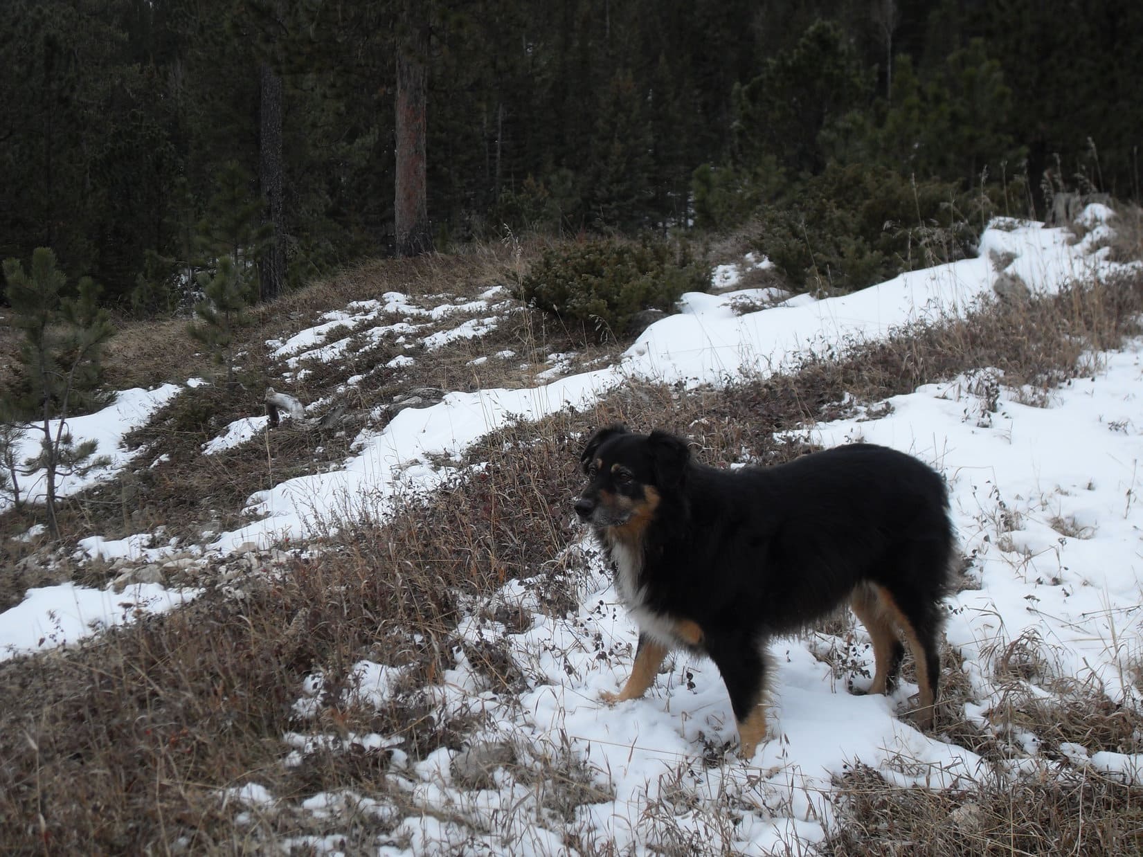
Lupe along USFS Road No. 294 at the start of Expedition No. 71. Despite the chill air and gloomy gray sky, Lupe was looking forward to a romp up Coulsen Hughes Draw with her friend Sidney. Photo looks W.
Abandoning the G6, Lupe, Big Sid, and SPHP started N up Coulsen Hughes Draw on USFS Road No. 591. Coulsen Hughes Draw is a moderately wide, shallow, grassy valley between two pine forested ridges. Snow covered much of the ground near the trees on the W side of the valley, but the road was close to the E side and largely snow-free.
On Expedition No. 68, Lupe and Sidney had reached the N end of Coulsen Hughes Draw from a different direction. It was about as far as they had gotten that time. SPHP’s old Black Hills USFS map showed that Crows Nest Peak(7,048 ft.) was only 2 or 3 miles farther NW from there. Lupe had never been to Crow’s Nest Peak. Maybe Lupe and Big Sid could find and climb it today, after exploring the length of Coulsen Hughes Draw?
Loop and Big Sid had only been running around sniffing for 15 or 20 minutes, when suddenly a vehicle could be heard coming down the draw. A pickup truck appeared with 3 guys in it dressed in camouflage and bright orange (the one defeating the other). SPHP chatted with them for a few minutes. They were elk hunters, but had seen nothing. Had SPHP? Nope.
Truth was, even if SPHP had, the hunters wouldn’t have gotten much help. Lupe and SPHP are more on the side of the elk.
The trek up Coulsen Hughes Draw was an easy, scenic, gentle climb. Lupe and Big Sid had a great time roaming at will.
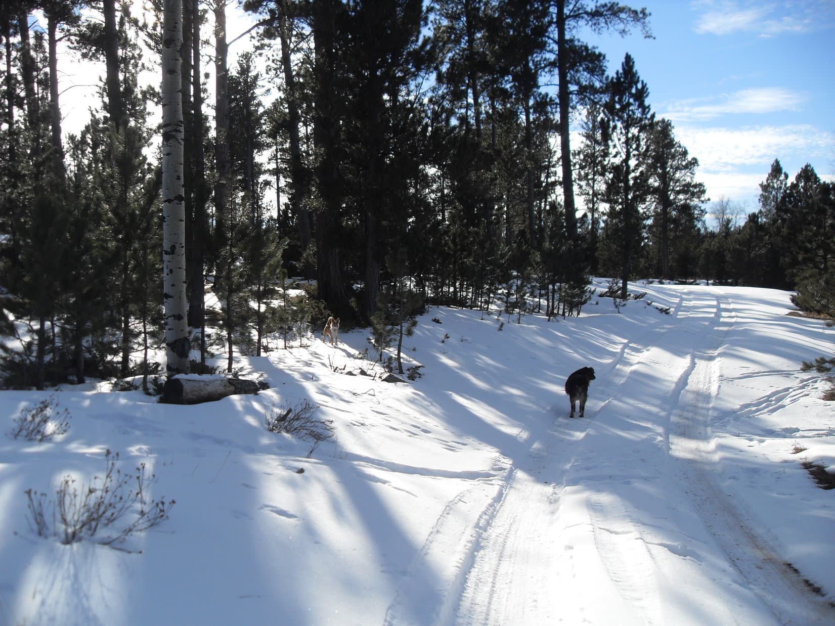
Looking SSE back down Coulsen Hughes Draw.Lupe on USFS Road No. 591 as it rounds a small hillside. Photo looks W.Sidney near the forest at the edge of the valley. Looks like he’s spotted something!A typical scene looking NW up Coulsen Hughes Draw. It was a pretty place for the dogs to run around. After the hunters went by early on, Lupe and Big Sid saw no one other than SPHP the rest of the day.Lupe comes running back after an exploratory foray up into the forest.
As Lupe and Sidney traveled up the draw, they passed by several stock ponds. The valley was gradually becoming snowier. The ponds were all frozen. By the time they’d gone 2.5 miles, Loop and Big Sid were getting close to the N end of Coulsen Hughes Draw. One more stock pond was up ahead. Beyond it, Coulsen Hughes Draw split in two.
The valley was wider and snowier by the time Lupe and Sidney reached the upper end of Coulsen Hughes Draw. The last stock pond is up ahead hidden behind the earthen dam seen a little R of Center. Here the draw split in two. Beyond the stock pond, Lupe and Sidney took the branch seen on the L. Photo looks NW.
Even before Lupe and Sidney reached this final stock pond, SPHP recognized the larger branch of the draw going N (R) as being the place Lupe and Big Sid had made it to on Expedition No. 68 before starting back for the G6. The smaller branch of the draw going NNW (L) looked more intriguing. This branch was totally new to Lupe, and led more directly toward Crows Nest Peak.
USFS Road No. 591 went up the larger N branch. Lupe and company left the road to explore the smaller NNW branch of the draw. An easy 0.5 mile trek brought Lupe to another dirt road. This had to be USFS Road No. 157, although the only sign present was an old wooden one that didn’t mention No. 157. It said only “Coulsen Hughes Draw” and pointed back the way Lupe had just come.
At this point, Lupe and Sidney were at least halfway to Crows Nest Peak, which was still another 2.5 or 3 miles to the NNW. However, SPHP’s USFS map showed no roads at all leading any farther in that direction. Going NE on No. 157 would only take Lupe away from Crows Nest Peak. Going W, the road disappeared into a dense forest. It would eventually lead to Miller and Procunier Springs, which were at least a little closer to Crows Nest Peak.
The last day of November is short. Time would be an issue. SPHP decided on a more direct route. Lupe and Big Sid crossed No. 157, covered the last of the open ground at the end of Coulsen Hughes Draw, and plunged into the forest traveling NNW straight for still unseen Crows Nest Peak.
There was considerably more snow in the forest than on the open ground in Coulsen Hughes Draw, but it wasn’t too bad. Before long, the terrain leveled off and looked like it was about to start descending. SPHP thought it best for Lupe to stay high. Off to the W was a higher ridge, so Lupe, Big Sid, and SPHP turned that way to gain as much elevation as possible.
The top of the ridge was all forested with no views in any direction. Lupe and Sidney turned N again and continued onward, picking a way forward through the snow, low juniper bushes, and scattered deadfall timber. Although the terrain went up and down a little, SPHP thought Lupe was still gaining net elevation, and hoped to get a glimpse of even higher ground toward Crows Nest Peak at some point.
Lupe started coming to little-used logging roads. Since travel was easier on the roads, Loop and Big Sid followed them for short stretches when they seemed to be going the right direction. Along one of these roads, suddenly Sidney was staring straight ahead. Movement in the trees! Sidney had spotted 3 of Lupe’s “giant deers”! Lupe hadn’t seen them yet, but the elk had seen Sidney. They were already disappearing into the forest.
The giant deers made another appearance 10 or 15 minutes later. This time both Sidney and Lupe saw them and took off after them. The elk had a huge lead, however. Within a couple minutes, both Loop and Sid gave up and returned, the elk long gone.
The logging road Lupe was on ended in the forest. Although it seemed like Lupe was quite high, no views existed in any direction. SPHP led on through the forest trying to head NNW while staying on the highest ground possible. Presently, open ground could be see ahead between the trees. Before reaching it, Lupe came to another logging road. The logging road took her to the edge of a long, wide field.
After leaving Coulsen Hughes Draw and USFS Road No. 157 behind, SPHP tried to lead Lupe and Sidney through the forest NNW toward Crow’s Nest Peak. Lupe ultimately arrived at this long, wide field. Photo looks S(?)Intrepid American Dingo explorer Lupe on her Expedition No. 71 search for Crow’s Nest Peak.Exploring is fun!
The new road divided almost immediately upon entering the field. Lupe had her choice of going S while gradually losing elevation, or going NW gradually gaining elevation.
Lupe and Sidney followed the road going NW up a hill. Soon the land leveled out on top. A few inches of snow were on the ground. Another group of 4 or 5 giant deers disappeared NE into the forest, but this time only SPHP saw them.
Near a stand of aspens, the road divided again. Lupe had her choice of going W or N. A marker was at the intersection. SPHP eagerly anticipated this possible clue to how close Lupe was now to Crows Nest Peak.
At the top of the hill, the road leveled out and passed by this stand of aspens. Beyond the aspens, the road divided again. Approaching the intersection SPHP could see a marker ahead, and looked forward to this possible clue as to how close Lupe and Big Sid were to Crows Nest Peak. Photo looks NW.
What the marker said came as a complete shock. No. 157! The same road Lupe and Sidney had left at the N end of Coulsen Hughes Draw! How was that possible? Lupe and Sidney scarfed up Taste of the Wild, taking a lunch break while SPHP sat on a log staring dumbfounded at the USFS map while pondering the implication of this news.
The map didn’t show No. 157 coming anywhere near Crow’s Nest Peak. Of course, the USFS map wasn’t very detailed. It was possible unshown minor side roads branching off No. 157 did. However, side roads would normally have an additional designation after the “157”, and this marker didn’t. Hmmm. SPHP shared a cheese stick with Looper and Sidney. The cheese was much appreciated.
The most likely conclusion SPHP could come up with was that Lupe and company had not been going N, but W. SPHP must have become disoriented somewhere along the way. With no landmarks or views, and the sun hidden all day by clouds, it could have easily happened. Oh, well. Now what? SPHP was no longer certain where Lupe was, or which direction was which.
Snack time was over! Lupe was still going to find Crow’s Nest Peak! SPHP led Loop and Big Sid along the road that supposedly went W. That lasted only a couple of minutes. Peering through the forest N of the road, it looked like the terrain was about to start losing elevation in that direction. Maybe there would be a view from the hillside? Lupe, Sidney and SPHP abandoned the road. Back into the forest! Onward!
Soon a view did appear. A noticeably higher ridge could be seen farther N. Crow’s Nest Peak? It looked like it was still 2 miles away, about right if Lupe had been going W earlier instead of N. Even though it meant losing elevation, SPHP decided to head straight for that ridge.
Lupe and Sidney were still having a great time! They enjoyed the march down the forested hillside. Lupe came to two large water tanks. Water was pouring into one of them from a pipe. A small overflow stream trickled down the hillside below the water tanks forming an ice flow.
Lupe followed the ice flow as far as it went, proceeding down into a valley. As soon as she got to the bottom, she regained lost elevation climbing up the other side. At the top she made a turn to the W, and once again emerged from the forest at the edge of another long, wide field.
About this time, the cloud cover started breaking up. It became possible to discern the position of the sun. SPHP thought Lupe had been going NW. The sun said she had been going SW, or maybe even straight S. Crazy! Simply crazy! One thing was certain, though. There’s no arguing with the sun.
A period of wandering through big fields and pastures began. Lupe started off heading first NW then N according to the sun, though it all felt wrong to SPHP. As near as SPHP could figure out, Loop was somewhere N of Miller and Procunier Springs. If true, Crow’s Nest Peak(7,048 ft.) was still as much as 2 miles N. However, from none of this territory could Lupe see the high ridge she had seen earlier.
The Carolina Dog came to a number of roads (all unmarked) and fences. After traveling N and circumnavigating a wooded area in the middle of an enormous field, Lupe made a foray into a forest even farther N. Traveling E near the forest’s edge, she came to another long stretch of open land extending NE from the enormous field. This area looked promising, but the sun was now clearly past its zenith. Lupe retreated S across the enormous field again.
Near the S edge of the field, Lupe and Big Sid found another road. This road was marked No. 157.2C. A short journey E on it led to a fallen log, suitable as a rest area. Lupe and Sidney finished off the Taste of the Wild. SPHP shared another cheese stick with them, while consulting the map.
Looking N back across the enormous field. SPHP remains convinced that Lupe and Sidney had come within almost a mile of Crow’s Nest Peak while on the far side.Sidney on USFS Road No. 157.2C. Photo looks ESE.Lupe relaxes in the sun on dry ground next to the rest spot log.Big Sid relaxes, too, wondering what’s next?Say, SPHP, I realize this is just crazy talk, but have you ever considered investing in a GPS device, or even just a decent compass? Maybe then we could actually get to where we’re going!I second that motion! Also, how about putting some more supplies in that pack? A bite of cheese stick every 3 hours just ain’t cutting it for me!
The map still didn’t show USFS Road No. 157.2C. It wasn’t any more enlightening than it had been earlier. Sigh.
Turning S and crossing the enormous field again had been an admission of defeat as far as reaching Crow’s Nest Peak was concerned. It wasn’t going to happen. Not today, anyway. Way out in the western high country of the Black Hills on the last day of November with the sun starting to slide toward the horizon, the only thing that made sense was to figure out where Lupe was, and begin the journey back to the G6.
SPHP decided Lupe should head W on No. 157.2C staying near the big fields. Sooner or later, the road would lead back to No. 157, probably right to that intersection near the grove of aspens where Loop and Sidney had taken their first rest break.
Even if one measly bite of cheese stick was inadequate, the second rest break was over. Onward! Big Sid seemed a little tired, but Lupe was still full of energy as they headed W on No. 157.2C.
A last look NNW across the enormous field. Somewhere out there, not too far away, was Crow’s Nest Peak. Lupe and Sidney weren’t going to reach it today.Time to start for home! Big Sid heads W on USFS Road No. 157.2C, seemingly a bit tired. Lupe still had energy to bound around. Here she’s standing at the edge of the forest. Photo looks WSW.Lupe races back to SPHP while Big Sid pauses to wait patiently for the signal to continue.
No. 157.2C went W only far enough to sweep around the W end of the forested hill to the S. Upon reaching the other side, it wound E and SE all the way back to the intersection with No. 157 near the grove of aspens. At least that had worked!
It would have been easy to simply follow No. 157 all the way back to Coulsen Hughes Draw, but now that SPHP was certain where Lupe was again, there wasn’t as much urgency as before. Lupe and company took a snowy road heading S from the aspen grove. Lupe could explore a different valley W of Coulsen Hughes Draw this way.
This route was beautiful and a pleasant trek. Lupe found a squirrel to bark at. Her excitement revived Sidney’s spirits as he got into the act, too. Another adventure was ahead. Lupe and Sidney saw 6 or 7 giant deers, the biggest herd yet! Oddly, they had been congregated near a large skeleton. As the live elk ran off, Lupe and Big Sid carefully investigated this most interesting find.
Lupe and Big Sid cautiously sniff an old skeleton. For some odd reason, 6 or 7 live elk had been congregated near it.
Lupe reached USFS Road No. 294 again a couple miles WNW of where the G6 was parked. SPHP was pretty certain she had come down the Dowell Spring drainage after passing E of Dowell Spring itself.
Instead of staying on No. 294 the rest of the way, Lupe and Sidney traveled through the grassy valley just to the S of it. More to sniff! More to explore! Although the sun was still shining on the ridges, all was in shadow down here.
After going a mile E, another road left No. 294 going first SW, but curving SE as it went up a side valley. SPHP was seized with a desire to see the sunset. Lupe and Sidney started up this side valley, eventually climbing the W side of it. Everyone reached the top of the ridge to the W, but there was no view due to the thick forest. All that could be seen was a final, filtered, glimmering between the trees.
With the last of the sunlight gone, a feeling of solitude descended. The sky was clear. No colorful sunset could develop. Still, quiet, remote. That was this place, this moment.
Still, quiet, remote, cold and dark was coming. Better get going!
Sidney was done. Filled with joy when he finally saw the G6, he trotted ahead of Lupe and SPHP as fast as tired paws would take him. He stood waiting for SPHP to arrive to open the door. Big Sid jumped in without the slightest hesitation the instant the door opened. Home, James!
It was nearly dark, but Lupe wasn’t in such a hurry. She was used to long days exploring. The Carolina Dog paused for several minutes, still sniffing the light breeze. Maybe she knew winter really was coming, and she wouldn’t be back in the high western hills again for a long time.
Lupe hadn’t made it to Crow’s Nest Peak, but Coulsen Hughes Draw had still been an adventure. Together with Big Sid, the Carolina Dog had out-hunted the hunters, and seen the giant deers. No one was shot dead or wounded as a result. Everyone, including the giant deers, would live to see more adventures in the days to come. End (4:44 PM, 27°F)
Day 19 of Lupe’s 2017 Dingo Vacation to the Yukon & Alaska!
6:02 AM, 37°F – The sky had been almost clear before sunset. SPHP expected to wake to blue skies. No such luck. Nothing but gray overhead. Lupe was famished. She gobbled down generous helpings of Alpo and Taste of the Wild before going back to sleep. The Carolina Dog was still exhausted after yesterday’s Cathedral Mountain(3,350 ft.) adventure. SPHP worked on the trip journal while rain showers came and went.
10:15 AM – Loop was awake again. Not raining now. Scattered patches of blue could even be seen. May as well hit the road. Lupe and SPHP left Cathedral Mountain heading N on the Dalton Highway.
As it turned out, Coldfoot (milepost 175) was only half a dozen miles away. SPHP gassed up the G6. Only $4.599 per gallon! Same as last year, and a bargain compared to the $5.50 per gallon they wanted back at the Yukon River. Be grateful for what you can get in the Arctic. Especially when they’re practically giving it away!
25 miles N of Coldfoot was a thrilling sight. Sukakpak Mountain was dead ahead! Lupe had climbed Sukakpak in 2016. As far as SPHP was concerned, Sukakpak Mountain(4,459 ft.) had been one of her most memorable adventures ever!
Sukakpak Mountain came into view 25 miles N of Coldfoot. The beautiful mountain was a thrilling sight! In 2016 Lupe had one of her most memorable adventures ever on Sukakpak. Photo looks NE.
A repeat of Lupe’s 2016 Sukakpak Mountain adventure would have been great fun, but the weather was just too iffy for that. Too little blue sky, and too many rain showers around. A huge effort that might easily wind up totally socked in and wet didn’t seem worth the risk.
Although Lupe and SPHP would have enjoyed a repeat of last year’s exploits up on Sukakpak Mountain, the weather seemed too iffy today. Too many rain showers around and not enough blue sky. Photo looks NE.Lupe along the Middle Fork of the Koyukuk River with Sukakpak Mountain in the background. Photo looks SE.
However, there was an easy adventure near Sukakpak Mountain that Lupe and SPHP would both love to do again. This part of the Brooks Range was the farthest N Lupe had ever been. In 2016, Lupe had gone on her Last Mile North adventure. This involved only a relatively short walk along the Alaska oil pipeline to a creek N of Dillon Mountain(4,820 ft.), then W to its nearby confluence with the Dietrich River.
From that confluence, Lupe had seen a mysterious dark mountain 10 miles farther N. She had seen it the day before from the top of Sukakpak Mountain, too. Not knowing its real name, or if Lupe would ever in her whole life be this far N again, SPHP had named that dark mountain the Mountain of the Midnight Sun.
Both to commemorate last year’s achievement getting so far N in the Brooks Range, and to celebrate her return, Lupe was going to repeat her Last Mile North trek to see the Mountain of the Midnight Sun again. Upon return, Loop was then going to go farther N than she had ever been before, exploring new territory and shattering her old record.
It was raining again when SPHP parked the G6 at a pullout on the W side of the Dalton Highway right before the bridge over the Dietrich River shortly before noon. After a bite to eat, and finishing catching up the trip journal while Loop napped, the rain was over. Still overcast and cool, but conditions were fine for the Last Mile North trek. SPHP donned a jacket and the rain poncho, and Lupe was underway. (1:01 PM)
The morning’s inactivity and early afternoon nap had done Lupe a lot of good. She was ready for action again! She crossed the bridge over the Dietrich River continuing N to milepost 207 on the Dalton Highway. In 2016, a small pullout slightly N of this point was as far N as the G6 had made it. Milepost 207 was exactly halfway along the 414 mile trip on the Dalton Highway from Livengood to Deadhorse at Prudhoe Bay.
Lupe crosses the bridge over the Dietrich River. Sukakpak Mountain is on the R. Photo looks SSE.Lupe visits milepost 207, the halfway point on the Dalton Highway. Milepost 207 is as far N as the G6 made it in 2016, and is just N of the Dietrich River. Dillon Mountain is in the background. Photo looks E.
Near milepost 207, Lupe took a short gravel access road W to the service road along the Alaska oil pipeline. Here, SPHP turned N following the service road.
Following the Alaska oil pipeline N was fabulous! For once, a nice level hike. Better yet, one surrounded by wonderful, remote mountains way up here in the unspoiled Brooks Range of N Alaska. It was an incredible feeling. And as much as SPHP liked this place, Lupe adored it. Her enthusiasm was boundless! The Carolina Dog ran, and ran, and ran.
Lupe repeating one of her easiest and favorite adventures of 2016, her Last Mile North trek along the Alaska oil pipeline W of Dillon Mountain. Photo looks NE.
Looper spent nearly all of her time out of sight in the bushes and forests just off the pipeline service road. She raced back and forth across the road as the mood struck her. Periodically she suddenly appeared a great distance away, and would streak back along the service road to check on SPHP’s progress. Her joy could be measured by the size of that huge pink tongue dangling from her open mouth.
Lupe on the oil pipeline service road coming back to check on SPHP. Photo looks N.Looking back at Sukakpak Mountain. Photo looks S.
After following the Alaska oil pipeline a little more than a mile N, Lupe reached a creek flowing W from the region N of Dillon Mountain. A huge area gets washed out by this creek when water levels are much higher in late spring and early summer. Now the creek was quite low, and occupied only a small portion of its rocky riverbed.
Lupe reaches the wide rocky stream bed now only partially occupied by the stream flowing W from the region N of Dillon Mountain (R). Photo looks SE.
The sun had come out. Lupe must have been hot. She drank deeply from the clear, cold creek. She plunked herself right down in the water numerous times. The current was so strong some places that it swept her downstream. Looper didn’t seem to care. The water wasn’t deep. She could get out whenever she pleased.
This Last Mile N adventure is just the best, isn’t it SPHP? I’m so glad we came back! Photo looks E.Hey, SPHP! We could stay right here the rest of my Dingo Vacation and do this every day! Great idea, aye?Loopster cools off in one of the stream’s main channels. This stream flows W to the Dietrich River from N of Dillon Mountain. Photo looks NE.Oh, yeah! My case of hot paws is cured!
Lupe and SPHP followed the creek downstream toward its confluence with the Dietrich River about 0.33 mile W of the Alaska oil pipeline. When the stream moved to its far S bank, SPHP was forced up into forest and stands of tall bushes. This slowed SPHP’s progress down a great deal. Meanwhile, Loopster returned to the forest to resume her free roaming adventures. SPHP had to call her back periodically so she didn’t wander too far away.
Approaching the confluence with the Dietrich River (coming in from the R). The mountain on the L is Peak 4363. Photo looks WNW.
Suddenly Lupe was there, back at the confluence of the Dietrich River and the clear stream she’d been following. This was the farthest N Lupe had ever been. A year and four days ago, she had been here. Off to the N, Lupe could see the Mountain of the Midnight Sun again. The top of the mountain was hidden by clouds.
Lupe in the clear stream she has been following W from the Alaska oil pipeline near its confluence with the much larger Dietrich River. The Mountain of the Midnight Sun is in the distance on the R. Photo looks N.The top of the Mountain of the Midnight Sun (R) is hidden by clouds. It felt wonderful, natural, and strange all at the same time to be seeing this view again. Photo looks N.Once again, a year and 4 days after the only other time she’d ever been here, Lupe stands at the confluence of the clear creek and the Dietrich River. The Mountain of the Midnight Sun (Center) is partially obscured by clouds. This was as far N as Lupe had ever been in her whole life. It was wonderful to be back! Photo looks N.
Being back here was an emotional experience. When Lupe had left this place last year, it was with a feeling that she would probably never ever be here to see this fabulous view and the mysterious Mountain of the Midnight Sun again, it was so far N and so far from home. Yet here she was, only a little over a year later. And Lupe had returned as the Most High Exalted Dingo of the Arctic Sisterhood! Being here seemed both so familiar and so natural, yet at the same time strange and incredibly remote again. It was wonderful to be back!
This time was going to be different, though. The plan SPHP had eventually put together for Lupe’s 2017 Dingo Vacation was that she would indeed return to the Yukon & Alaska. Lupe would come back here, to this very spot, but this time she would go even farther. Lupe was going to continue N beyond Atigun Pass, crossing the spine of the mighty Brooks Range. She was going to see Galbraith Lake beyond the end of the mountains, and climb Lake Benchmark Mountain(5,000 ft.) where she would have a tremendous view of the North Slope of Alaska.
Yes, Lupe was going to see that distant far N land beyond Alaska’s last mountain range! The Carolina Dog would get to see the North Slope’s vast empty boreal tundra extending beyond vision to the Arctic Ocean at the top of the world.
SPHP had learned something since Lupe had last been here. For many months after Lupe returned home from her 2016 Dingo Vacation, SPHP had purposely not looked at the topo maps to see if they showed a real name for the Mountain of the Midnight Sun. Finally though, SPHP did look. Yes, the maps did show a name. The Mountain of the Midnight Sun’s real name was Snowden Mountain (6,420 ft.).
The topo maps confirmed one other thing. SPHP had hoped Lupe might be able to climb the Mountain of the Midnight Sun if she ever returned, but feared that the mountain was probably too difficult. The topo maps concurred. It wasn’t likely SPHP would be able to climb such a rugged peak, which meant Lupe never would either. Still, Lupe could drop by for a look at the mountain today when she went by it heading N. A slim chance still existed an ascent might look feasible.
Lupe and SPHP lingered at the confluence of the Dietrich River and the clear stream a while. Loop relaxed on exposed riverbed next to the river, while SPHP pondered this place and this moment. For more than a year, this had been the farthest N Looper and SPHP had ever been. For more than a year, it had been a dream, at first only faintly held, to come back some day. Now, after today, this hike and this confluence would no longer be Lupe’s last mile N. However, it would forever be a special place. The Carolina Dog and SPHP both loved being here.
Lupe relaxes on exposed riverbed next to the Dietrich River with Sukakpak Mountain in the distance. Photo looks S.
The long dreamed of moment passed. Lupe was ready. Time for action! New adventures, glorious ones, were ahead! First things first, though. The American Dingo was eager to relive all the great fun of coming here on the way back to the G6 again.
The forest rang with the shrill, excited barking of the Happiest Dingo on earth. Lupe sped through the forests following whatever secret paths her nose led her to. She didn’t waste a single minute. It was another grand time for both Loop and SPHP, and like all grand times, over too soon. There seemed to be little doubt that Lupe would have rated the past two hours the very best of her entire Dingo Vacation so far.
Oh, yeah! I got to enjoy this bliss all over again. Am I the luckiest Dingo on earth, or what? Sukakpak Mountain dead ahead. Photo looks S.Back at the Dietrich River again with only the bridge to cross to get back to the G6. Sukakpak Mountain in the background. Photo looks S.Sukakpak Mountain in the Brooks Range from the Dietrich River. Photo looks S.
The sun was out. The temperature had soared to 66°F by the time Lupe reached the G6. (3:06 PM) This was a rare opportunity to dry some things out on the roof. Lupe rested in the shade, listening to the rippling Dietrich River with a beautiful view of Dillon Mountain(4,820 ft.), still the northernmost mountain Lupe had ever climbed.
While wet stuff dried on the roof of the G6, Lupe rested nearby in the shade listening to the Dietrich River with a view of Dillon Mountain, still the northernmost mountain she had ever climbed. Photo looks E.
Rain showers were visible not too far away the whole time. The sunny half hour ended as clouds returned. At least some things had dried off. SPHP took everything off the roof of the G6 and put it all away. It was time. (3:45 PM, 59°F)
Come on, Loopster! Our time’s up here.
Oh, are we really going N now? Farther than ever before?
Yes ma’am. The Most High Exalted Dingo of the Arctic Sisterhood is going to see some territory she’s never seen before. With a title like that, it’s almost an obligation for you to explore more of the Arctic, you know.
Are we going to climb the Mountain of the Midnight Sun?
We’ll see. Probably not. Don’t think it’s anything we can do, but we’ll stop and take a look just in case. It’s not that far away from here. At least you will get to see your Mountain of the Midnight Sun up close.
And then what?
Well, we’ll have a beautiful drive through the Brooks Range along the Dietrich River valley. Eventually we’ll get to another mountain Richard Carey wrote a trip report about on Peakbagger.com. He hasn’t steered us wrong yet. I’m hoping you’ll be able to climb it.
What mountain is that, SPHP?
Table Mountain. We should be able to see it from the Chandalar Shelf.
Table Mountain? Sounds kind of boring. Plenty of Table Mountains, but there’s never a Chair Mountain, is there? Chandalar Shelf sounds sort of exotic, though. I like it here, but I suppose you’re right, as Most High Exalted Dingo of the Arctic Sisterhood, I ought to explore more of the Arctic. It would be hard to explain to the rest of the sisters, if I didn’t.
Clever, Loop, but actually you have climbed a chair mountain. Remember Kings Throne Peak near Kathleen Lake back in the Yukon? A throne is a fancy chair.
Oh, I never thought of that, SPHP.
The Dalton Highway’s beautiful pavement ended even before Lupe reached milepost 210 a couple miles N of Dillon Mountain. That was a shame. The highway was now mud, gravel, and potholes. Only a few miles farther, as Lupe was nearing the Mountain of the Midnight Sun, SPHP saw an impressive view of Dillon Mountain in the rear view mirror. It was worth a quick stop.
Lupe near milepost 213. Her Mountain of the Midnight Sun (R) is only a few miles away now. Unfortunately, the Dalton Highway has already reverted to mud and gravel. Photo looks NNW.An impressive view of Dillon Mountain from milepost 213 of the Dalton Highway. Photo looks SSE.
Lupe reached the Mountain of the Midnight Sun at milepost 216. A glance told the story. It was a great mountain, but SPHP wasn’t prepared to tackle anything like that. Despite the mountain having been a dream goal for over a year, Loop and SPHP paused only briefly before continuing on.
The summit of the Mountain of the Midnight Sun is hidden in the clouds somewhere to the R, perhaps off the edge of this photo. SPHP could tell at a glance that this just wasn’t happening for Lupe. Disappointing, but not unexpected. Photo looks NE.
The drive up the Dietrich River valley was as beautiful as SPHP had promised it would be. The Dalton Highway eventually left the river, climbing fairly steeply up the side of a ridge. Near the top, the road curved to the R. A broad plain flanked by mountains came into view ahead. SPHP parked the G6 at a large pullout on the R (milepost 237). Lupe had reached the Chandalar Shelf.
Clouds prevailed over most of the sky, but Lupe stood in weak sunshine when she got out of the G6 for a look. (6:00 PM) The Chandalar Shelf was gorgeous! A treeless tundra of colorful low bushes stretched away for miles. The flanking mountains were dark beneath the clouds, but weren’t rough or particularly high.
Loopster arrives at the Chandalar Shelf. Photo looks E.
Table Mountain(6,314 ft.) was in view more than 4 miles S of the pullout. Though the summit was partially obscured by clouds, and looked like it might have a dusting of new snow on it, SPHP was excited to see that Table Mountain looked like an eminently climbable peak for Lupe!
It was much too late, and weather conditions weren’t right anyway, to consider an ascent today. If she stuck around, Lupe could climb Table Mountain tomorrow, though, if the weather would cooperate. If Loop stayed here overnight, she could get an early start in the morning.
Beyond the Chandalar Shelf, the summit of Table Mountain (R of Center) is partially obscured by clouds. SPHP could see enough to tell that Lupe ought to be able to climb Table Mountain easily enough, if the weather would cooperate. Photo looks S.
Lupe was interested in making a brief foray out onto the Chandalar Shelf. It seemed like a good idea. Loop and SPHP quickly learned that the ground was soggier than expected. When the time came, the best route to Table Mountain across the Chandalar Shelf would likely be on the highest terrain possible. Fortunately, this was pretty much the most direct line to the mountain, anyway.
Lupe makes a brief foray out onto the Chandalar Shelf. Photo looks E.Lupe discovered this faint set of vehicle tracks heading straight for Table Mountain. When the time came to climb the mountain, she intended to start out for it this way. Photo looks S.
Perhaps Lupe and SPHP should have stayed at the Chandalar Shelf overnight. Then Lupe might have climbed Table Mountain the next day, but the prospect of seeing new territory made continuing on exciting and attractive. The Arctic stays light a long time, even in mid-August. Lupe had hours of daylight left. Besides, she would eventually have to return this way. She could climb Table Mountain then.
Looking back at Table Mountain (L) as Lupe continues N on the Dalton Highway. Photo looks SSW.
Lupe was only a few miles beyond the Chandalar Shelf when it became apparent that the Dalton Highway would soon start climbing to Atigun Pass (4,739 ft.). The road was wet, soft, and slick, and the tops of the mountains here were definitely sporting new snow. What would the road be like? Could the G6 even make it to Atigun Pass?
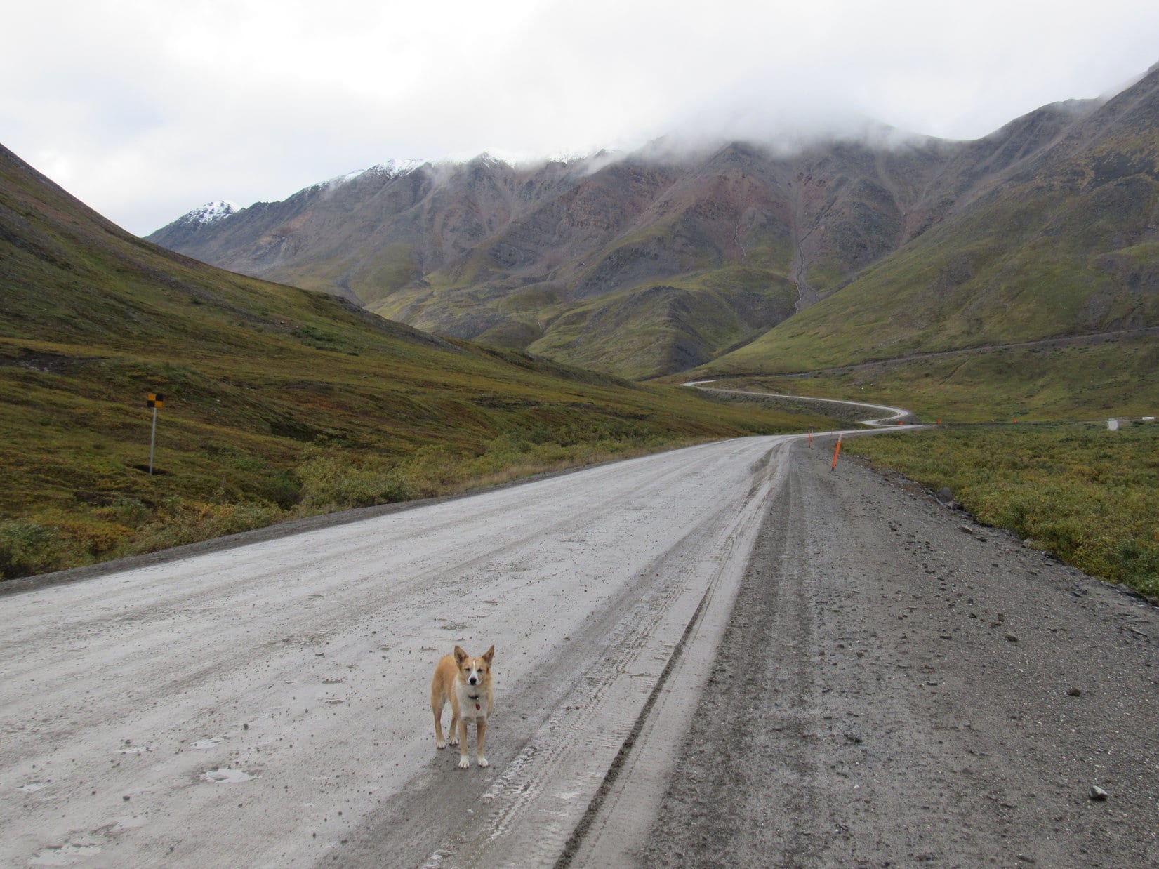
Lupe on the Dalton Highway only a few miles N of the Chandalar Shelf. The highway would soon start its ascent of Atigun Pass. Photo looks NNE.The Dalton Highway starts up to Atigun Pass ahead on the R. Photo looks NNW.18th of August, and the mountaintops were sporting a dusting of new snow. Photo looks NW with help from the telephoto lens.
The climb up to Atigun Pass initially seemed daunting. The road was steep, wet and slick. A light rain was falling, and the possibility of snow on the road ahead was worrisome. However, the G6 was doing fine.
The Dalton Highway climbs to the R toward Atigun Pass. Doesn’t look scary from here. Photo looks NNW.Lupe stands on the Dalton Highway partway up to Atigun Pass. So far, so good. Photo looks NE.Looking back down. The G6 was doing fine despite the wet road. Photo looks SW.
The top of Atigun Pass (milepost 245) was only 2.5 miles from the big curve where the Dalton Highway began gaining elevation in earnest. Despite initial trepidation, the ascent had gone quickly and smoothly. The pass was 38°F when Lupe arrived. There was a huge pullout on the E side of the highway. Sadly, and rather surprisingly, Loop found no commemorative sign of any kind.
Lupe arrives at Atigun Pass for her first time ever to find 38°F weather on August 18th, light rain, a huge wet pullout, and no commemorative Atigun Pass sign of any kind.
Atigun Pass (4,739 ft.) is the high point of the Dalton Highway, and on the continental divide along the spine of the Brooks Range. S of the pass, water drains W to the Bering Sea, part of the North Pacific Ocean. N of the pass, water flows N to the Arctic Ocean.
As geographically significant as Atigun Pass might be, it didn’t take a Carolina Dog long to conclude her inspection of cloudy mountains, cool damp weather, and a muddy parking lot. After a few minutes, Loop was ready to go see whatever was N of the pass.
The drive down the N side of the Brooks Range was fascinating! For a couple of miles, the Dalton Highway seemed steeper here than it had been S of Atigun Pass. The road wound around making big curves along the sides of the mountains. Up high, a heavy mist was coming down. Fog drifted among mountains capped with new snow, most summits hidden in the clouds.
SPHP drove slowly so Lupe could take it all in. The American Dingo stopped a couple of times on the way down, too, just to better appreciate being N of Atigun Pass for the first time ever.
Lupe on a little side road just off the Dalton Highway. Wow! Here she was, N of Atigun Pass in the Brooks Range!Though it would have been fun to see these mountains in bright sunshine, the chill mist and fog only added to the sense of mystery and remote solitude.Looking up at the new snow on the mountaintops, SPHP was struck by the notion that maybe Lupe shouldn’t stay too long N of Atigun Pass. It wouldn’t take much of a snowstorm to make the Dalton Highway impassable to the G6, and apparently it was already autumn here in mid-August!
After a couple of miles of steep, wide turns, Lupe could see she was now down close to where the road’s grade was about to moderate. The Dalton Highway was heading into a long valley. Small streams by the road were some of the headwaters of the Atigun River beginning a long journey to the Arctic Ocean.
A couple miles from Atigun Pass, the Dalton Highway headed for a long valley. Creeks near the road were the beginnings of the Atigun River. Photo looks N.
The Dalton Highway began straightening out. It made gentle curves along lower slopes of the mountains following the newly forming Atigun River down the valley. A dozen miles from Atigun Pass, a major tributary came in from a big valley to the SW. The Atigun River was already getting big, and the valley was widening out.
Lower down, the Dalton Highway started leveling out making long gentle curves along the base of the mountains as it followed headwaters of the Atigun River downstream. Lupe was beyond the rain and mist she’d experienced at Atigun Pass. Photo looks N.The Atigun River was much larger and the valley widened out after a major tributary of the river joined in from a big valley to the SW. Lupe stands in sunshine within sight of a few encouraging patches of blue sky in the widened valley. Photo looks N.
Not a tree grew anywhere. Tall bushes were uncommon, though plenty of low ones grew. The Atigun River valley was a starkly beautiful boreal tundra flanked by some of the northernmost mountains in Alaska.
Before too long, it began to look like the Dalton Highway would soon be approaching the end of the Brooks Range. SPHP didn’t realize it yet, but Loopster could already see Lake Benchmark Mountain(5,000 ft.), the mountain she would try to climb tomorrow hoping for a glorious view of Alaska’s vast North Slope.
The Dalton Highway is starting to approach the N end of the Brooks Range here. SPHP didn’t realize it yet, but Lake Benchmark Mountain (far L in the distance), which Lupe hoped to climb tomorrow, is already in sight. Photo looks N.
Where the Atigun River came closer to the Dalton Highway, SPHP parked the G6. Being here was a dream come true! Time to get out and enjoy! Loop happily explored the tundra, while SPHP walked over to the river.
Lupe stopped here where the Atigun River flows close to the Dalton Highway. Alaska’s North Slope starts beyond the mountains seen in the distance. Photo looks N.Lupe visits the fabled Atigun River in the northern Brooks Range. Photo looks N.The Atigun River really is beautiful, SPHP! However, I have a feeling I won’t be barking at any squirrels around here. I haven’t seen a single tree since before we reached Atigun Pass! Photo looks N.Hi, there! This is Lupe, the Most High Exalted Dingo of the Arctic Sisterhood reporting in from the E bank of the Atigun River on the N side of the Brooks Range, just in case any of you other Arctic sisters are thinking of coming up here and would like to know what to expect. Photo looks SSW.
Lupe enjoyed a short romp near the Atigun River, but she was getting very close to being as far N as SPHP had planned for her big 2017 Dingo Vacation. She would soon be close to Lake Benchmark Mountain and Galbraith Lake where her journey N would end. In fact, a dark cluster of peaks up ahead must be where Lake Benchmark Mountain was!
It was exciting being here, nearing a new even more northerly last mile N record for Lupe. What would she see there? Lupe and SPHP returned to the G6 to keep going. Soon a gap appeared in the mountains ahead. Beyond the gap was a distant flat land. The North Slope! That was where it began!
Only a little farther on, this gap appeared in the mountains ahead. Beyond the gap, Lupe could see the beginning of the North Slope (Center)! Photo looks NW.SPHP was certain that the highest ridge R of Center in this cluster of dark mountains was Lake Benchmark Mountain, the peak at the N end of the Brooks Range that Lupe had come all this way to climb! However, Lupe later discovered SPHP was in error. (Hardly a first!) Photo looks N with help from the telephoto lens.Mountains W of the Dalton Highway beyond the Atigun River. Photo looks W.A look back to the SSW. The Atigun River valley is on the L.
The Atigun River did not flow N through the gap Lupe had seen directly out onto the North Slope. Instead, shortly before reaching the gap, the river turned E entering a narrow valley between high mountains. Near this E bend, the Dalton Highway crossed a bridge over the Atigun River, leaving it behind and continuing N toward the gap.
The highway was going uphill now, bordered on one side by the Alaska oil pipeline and a high ridge Lupe would climb tomorrow on her way to Lake Benchmark Mountain somewhere to the E. On the W side of the highway, Lupe ought to be seeing Galbraith Lake any moment now. Sure enough, Galbraith Lake quickly came into view.
The Dalton Highway continues N after crossing a bridge over the Atigun River where the river turns E. The Alaska oil pipeline parallels the highway below the last mountains of the Brooks Range. Photo looks N.A couple miles N of where the Dalton Highway crossed a bridge over the Atigun River, Lupe reaches a view of Galbraith Lake. Only the S end of the large lake is seen here. Photo looks SW.
Galbraith Lake lies at the base of the N side of the Brooks Range. The S end of the lake is in a wide plain near high mountains, but the N end of Galbraith Lake extends out into the beginning of the North Slope. Lupe could see the entire lake from the Dalton Highway. She was now about as far N as SPHP had planned for her to go – at the end of her northern explorations.
Lupe stands on the Dalton Highway with a view of the N end of Galbraith Lake. This was about as far N as SPHP had planned for her to go. Photo looks W.
Standing there on the Dalton Highway, with glistening Galbraith Lake in full view beneath a gray sky, SPHP was seized with the notion that Lupe ought to go farther. Yes, Loop could see the beginning of the North Slope at the N end of Galbraith Lake from here, but the sky was lighter over that way, and the Dalton Highway was still going up as it continued N.
Maybe by going a few miles farther, Lupe could get to some higher point where the light would be better, and she could see much more of the North Slope? It seemed worth a shot. It was late in the day. Lupe and SPHP had nothing better to do before sunset.
It was a good decision. As SPHP drove N, the light did improve, and so did the views of the North Slope. The Dalton Highway reached the top of the hill it had been climbing. SPHP continued driving N over a couple minor rises looking for a place to park the G6. Several miles beyond the last hills of the Brooks Range, a wide side road appeared on the W side of the Dalton Highway near milepost 236 or 237. Yes!
Loopster, Loopster, come on! Hurry! This is it! What you’ve come so far to see! We’re in the nick of time!
Lupe was almost alarmed by SPHP’s excited, wild behavior, but being a bold American Dingo, leapt out of the G6 ready for anything.
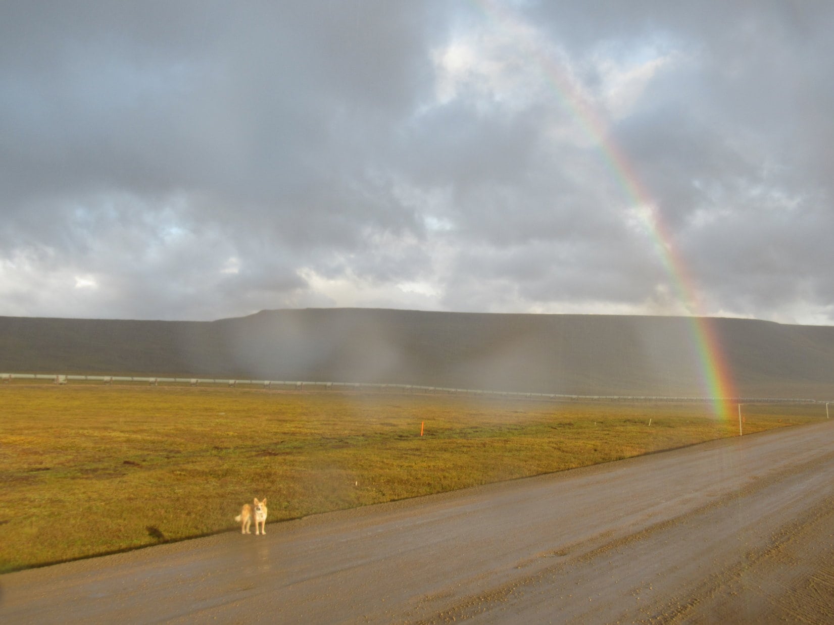
It was raining. And sunny. Gentle rolling fields of gold extended N as far as Lupe could see toward big hills bordering on small mountains on the horizon. To the W a line of much higher mountains marked the N edge of the lonely, remote Brooks Range. To the SE, a last ridge stood high and dark in a shadowy gloom. In sunlight, before this forbidding ridge, extending down to the golden boreal tundra, glowed a double rainbow.
It was raining. Photo looks NW.Gentle golden slopes extended as far as Lupe could see to high hills and small mountains on the horizon. Photo looks N.And sunny. Remote peaks along the N edge of the Brooks range appear miles beyond the North Slope’s billowing sea of gold. Photo looks WSW.In front of the last high, shadowy ridge of the Brooks Range, glowed a double rainbow. Photo looks SE.Loop in dazzling sunlight at the end of the rainbow on Alaska’s North Slope.
It was an amazing moment, so full of joy! This was it! This was the unbelievable North Slope even better than any dream. Lupe had arrived when the whole world appeared as a boundless treasure. The North Slope’s limitless tundra was a promised golden land at the end of the rainbow.
Such magical moments can’t last. They flit away, never to return, like carefree butterflies blown far and wide, lost wherever soft breezes take them. The rainbow, the dazzling sunlight, the glistening raindrops would all quickly fade or pass by. Yet for a few wonderful fleeting moments, it was all so very real, as real as anything ever was.
On the Dalton Highway in the promised land of Alaska’s North Slope. Photo looks E.Sweet Loop near the end of the rainbow. Photo looks SSE.N of the Brooks Range. Photo looks SE.
Chasing rainbows, Lupe got cold and wet. She was tired and hungry. SPHP turned the G6 to face the sunset. Alpo for Lupe, then her warm blankie. At evening’s end, a pale sun sank into a bank of gray clouds. No colors, no beauty, simply gone. The vast gray tundra stretched away to infinity. Lupe snoozed as SPHP watched the North Slope fade away. (10:30 PM, 41°F)
In North Slope Dingo Dreamland.So this is it? The promised land of the North Slope with a rainbow and everything? I’m going to close my eyes and make a wish. Maybe there will be squirrels here when I open them!A magical moment on the North Slope, Alaska 8-18-17