Lupe was back, and that meant she already had good news! There were a few more inches of snow around than when Lupe had been here on Black Hills, SD Expedition No. 164 just 4 days ago, but once again the G6 had made it to the intersection of Six Mile Road and USFS Road No. 301.1A (4-1-16, 11:06 AM, 32°F), only 0.33 mile E of Copper Mountain.
The good news was that there was now absolutely no question whether it would be possible to get up on the summit of Odakota Mountain (7,200 ft.) tomorrow morning. Odakota Mountain was just a couple of miles away from the G6 as the roads went, and SPHP believed the G6 could get even closer.
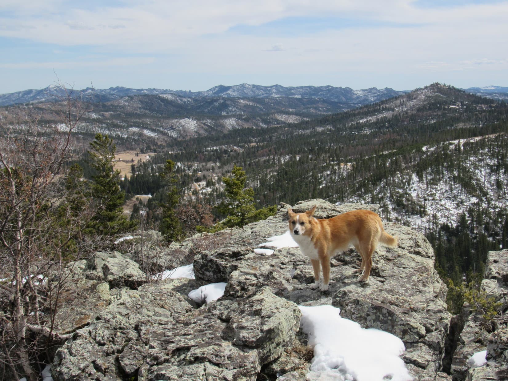
Although it wasn’t really necessary for Lupe’s updated scouting report, Lupe and SPHP went on to climb both Odakota Mountain and Copper Mountain (6,920 ft.).


Lupe’s updated scouting trip had been necessitated by a 3 hour rain at Lupe’s home on Wednesday morning, 3-30-16. To add insult to injury, the following day, Thursday, 3-31-16, featured a series of intermittent mini-blizzards as squall lines repeatedly passed through the Black Hills region all day long. It was impossible to know how much snow had fallen at over 7,000 ft. without coming here again today. Lupe didn’t mind in the least. She was having fun!
The amount of new snow near Odakota Mountain was perfect! Enough to beautify the mountains, yet not enough to prevent easy access. Lupe and SPHP were excited and pleased!
Back at home, SPHP served as Lupe’s secretary and emailed out her updated Odakota road condition report to the interested party. “It’s ON! … Meet as previously planned.” The response came a short time later. “Perfect! This is EXACTLY what I wanted to hear! … Looking forward to making this happen, Jobe Wymore”
The next morning (4-2-16), Lupe and SPHP were waiting for Jobe at Medicine Mountain Road 2 miles S of Crazy Horse. Within 30 minutes, Jobe arrived in a rented silver vehicle that was an absolute BEAST! High clearance, 4WD, huge knobby tires. SPHP should have known. The quote on Jobe’s Peakbagger.com account homepage read “The will to win means nothing without the will to prepare. – Juma Ikaanga, 2:08:01 marathoner.” Jobe was ready for anything.
A few minutes later, with the G6 safely ditched a few miles in on Medicine Mountain Road, Lupe and SPHP joined Jobe in the BEAST. Before long it was parked at the junction of Six Mile Road and USFS Road No. 693 near Odakota Mountain. Lupe, Jobe & SPHP began the 0.5 mile, snowy trek to the summit of Odakota.
On 3-26-16, Jobe Wymore had selected Lupe to serve as his local peakbagging expert after seeing that she had been to Odakota Mountain several times. He had emailed Lupe. All he ready wanted to know was how much snow there was, and whether or not the roads were open. Lupe emailed back that she would find out. That’s how Lupe came to be Jobe’s advanced scout.
Jobe lives in the Portland, Oregon area and had already bought a plane ticket to Denver. His main peakbagging objectives were Wildcat Mountain (5,025 ft.) and Hogback Mountain (5,062 ft.) in the Wildcat Hills S of Scottsbluff, Nebraska. However, if Odakota Mountain in the Black Hills of South Dakota was accessible, he wanted to drive the extra 200+ miles N to ascend it, too.
SPHP hadn’t initially recognized Jobe Wymore’s name. A day or two after Lupe had promised Jobe she would check out conditions near Odakota Mountain, SPHP finally looked Jobe Wymore up on peakbagger.com. It was an eye-opener. Jobe was not your average, casual day-hiking peakbagger like Lupe and SPHP. Jobe was a real mountaineer!
Over 2,400 ascents, over 1,300 different mountains climbed, 205 ascents of Grandeur Peak (8,299 ft.) over 19 years, and 600 ascents of Malans Peak (6,960 ft.) alone in less than a 2.5 year period. Jobe had climbed the highest mountains in all 50 U.S. states including Denali (20,310 ft.) in Alaska. All but 6 of them, twice. The lowest peak in his top 10 summits by elevation was Mt. Whitney (14,495 ft.), the highest peak in the lower 48 U.S. states.
It went on – successful summits in Puerto Rico, U.S. Virgin Islands, Mexico, Guatemala, Chile, Argentina, Ecuador, and Australia. Jobe had been up extremely remote peaks including Mt. Angayukaqsraq (4,700 ft.) in NW Alaska, and Mt. Bona (16,500 ft.) in SE Alaska. Jobe had been to the highest points in every county of Wisconsin, Colorado, North Dakota, Oregon, New Mexico, Utah, Wyoming and Nevada.
Furthermore, Jobe had climbed with other people whose names SPHP did recognize from Peakbagger.com – Edward Earl, Dick Ellsworth, Dave Covill, Greg Slayden, Gustav Sexauer and Steve Mueller.
Yes, meeting Jobe was like meeting a celebrity. Lupe wasn’t fazed. Carolina Dogs are celebrities themselves! Soon advanced scout and Black Hills peakbagging expert Lupe was posing with peakbagger extraordinaire and mountaineer Jobe Wymore at the summit of Odakota Mountain.


Although Odakota Mountain is the 2nd highest in all of South Dakota at 7,200 feet, the mountain is kind of a mess covered with deadfall timber. There are still enough trees around to interfere with the views in every direction at the top. SPHP was a little afraid that someone of Jobe’s vast experience might find Odakota disappointing.
Jobe’s reaction was surprising. For a few moments he was entranced. He said he had been meaning to climb Odakota for 20 years. For Jobe, it was a beautiful moment, the fulfillment of a long held ambition.
Lupe and SPHP were glad Jobe liked Odakota Mountain and the Black Hills. Jobe wanted to visit a couple more peaks in the few hours he had remaining before having to head S to Nebraska. Lupe, Jobe and SPHP went to nearby Copper Mountain, which isn’t as high as Odakota, but has a better viewpoint.


There were lots of places Lupe would have liked to take Jobe in the Black Hills, but Jobe’s time was very limited. Cicero Peak (6,166 ft.), S of Custer, SD has a 1.5 mile long access road (USFS Road No. 338), which goes almost all the way to the top. The road was closed, but Jobe had time to hike it with Lupe and SPHP.
Lupe enjoyed trotting along on and off the road, while Jobe and SPHP were engaged in conversation. Jobe was full of fascinating tales about people and mountains. SPHP recognized some names and places, but knew nothing about many others.
Jobe told of a mountaintop writhing with baby rattlesnakes emerging from a huge den at the summit. He had stories about a life-threatening storm on Mt. Bona (16,500 ft.) in Alaska, and being forced to turn back on 3 separate occasions by weather on Aconcagua (22,841 ft.), the highest peak in the Andes of South America.
Perhaps the most riveting tale of all was about the tragic death of Edward Earl. Edward drowned on 6-19-15 while attempting to cross the Jago River in NE Alaska after two failed attempts at climbing Mt. Isto (8,976 ft.), the high point of the Brooks Range. Although Jobe had not been on that trip, Jobe personally knew Edward Earl and all three of the friends that had been with him on that fateful day.
It was all so interesting, that SPHP failed to take any photos, except at the top of Cicero Peak, and then forgot all about the camera case.

After climbing Cicero Peak, Jobe’s few hours in the Black Hills were up. He had to head S to the Wildcat Hills of Nebraska to complete his main peakbagging objectives of this trip before flying back home late tomorrow afternoon. Even though Jobe had to leave the Black Hills, Lupe’s adventures with Jobe weren’t over yet! Jobe didn’t mind if Lupe and SPHP tagged along and went to the Wildcat Hills, too.
So, Lupe and SPHP in the G6, followed by Jobe in the BEAST, headed S for Scottsbluff, Nebraska. The drive went through desolate, sparsely populated SW South Dakota and NW Nebraska. It was the sort of territory Lupe and SPHP love. Unspoiled vistas of hills and prairies for SPHP, and an abundance of cows and horses to bark furiously at for Lupe.

After gassing up in Scottsbluff, Jobe took the lead in the BEAST, with Lupe and SPHP following in the G6. Jobe drove through Scottsbluff and Gering, continuing S on 4-lane Highway 71. A couple of miles S of the Scotts Bluff/Banner County Line, Jobe turned W on County Road No. 40. After a mile, it turned SW for a short distance before dead-ending at a yellow house, apparently the only home served by County Road No. 40.
Jobe knew that this house was the home of Richard Archer, who refers to himself as either “Arch” or “The Bluffman”. Arch is actually a tenant and not the owner of the property, but both Arch and the owner are not only tolerant of respectful hikers, but curious and friendly toward them as well. Wildcat Mountain and Hogback Mountain are both on the owner’s ranchlands.
There was no answer when Jobe knocked on the door. Since it was late afternoon already, the plan had been to get permission from Arch to come back and climb Wildcat and Hogback Mountains in the morning. Unfortunately, Arch wasn’t home. Jobe needed paper to write a note to leave at the house. By the time SPHP returned with the paper, Jobe had a new idea.
Although it was fairly late in the day, there were still probably a good 3 hours of daylight left. Would Lupe and SPHP be willing to climb Wildcat and Hogback Mountains now? The whole round trip was only about 5 or 6 miles, give or take a little. Lupe and SPHP were fine with that. Sure! Sounds realistic. Maybe we can even get some sunset shots from Hogback Mountain?
Jobe wrote out two notes, one to leave on the door of the house and one on the dashboard of the BEAST. As soon as they were in place, Lupe, Jobe & SPHP headed out through a pasture behind the house. A faint road lead WSW for a while before being forced to turn S by a ravine to the W.
The climb was gradual at first, but became steeper as the road continued on. Eventually, the road played out. A muddy single track trail continued S, climbing at a moderately steep pace. There was an incredible amount of cactus around, but amazingly, Lupe didn’t seem bothered by it. She trotted right along with SPHP, following Jobe up.
When the trail reached the S end of the ravine to the W, the trail more or less disappeared too. The summit of Wildcat Peak was now just 0.5 mile to the W. Lupe, Jobe, and SPHP followed a long slope up the mountain. The very last part was a steep little climb up to a flat, roomy summit. Jobe made it up there first, followed by Lupe and SPHP a couple minutes later.


After 10 minutes or so spent enjoying the views up on Wildcat Mountain, the slanting rays of the sun indicated it was time to press on to Hogback Mountain, now just a mile away to the NW. There were small cliffs on the NW side of Wildcat Mountain, and larger ones to the S. Everyone had to go back to the NE end of the summit area to lose a little elevation before turning W along the rather steep N slope.
It wasn’t too far down to the long ridge NW of Wildcat Mountain that led to Hogback Mountain. SPHP was a little slow coming down, but Lupe and SPHP soon caught up with Jobe, who was waiting on the ridge. The way ahead looked easy! Jobe and SPHP pressed onward.
Poor Lupe didn’t. She wasn’t coming. She didn’t bark; she didn’t whine. She just sat silently on the snow being left behind. Jobe noticed first.

The cactus had finally gotten to Lupe. Jobe and SPHP returned to her. Several times, Jobe and SPHP inspected all her paws and pulled fine little cactus spines out of them. Lupe started onward again a couple of times, but she didn’t get far. Cactus loaded with more sharp spines were practically everywhere.
Back home in her Black Hills of South Dakota, Lupe has become a local peakbagging expert. Most places in the Black Hills, except at lower elevations near the prairie or toward the drier southern hills, there aren’t any cactus, or very few. Here in the Wildcat Hills of Nebraska, the cactus infested ridge had reduced the intrepid American Dingo to just Tenderpaw Lupe.
The cactus were terrible. Lupe kept stopping. She was done. She didn’t whine. She just sat there and lifted one paw up to SPHP and Jobe asking for help. As far as Lupe was concerned, the Wildcats and Hogs could have these hills! SPHP told Jobe to go on. SPHP would start back to Arch’s house with Lupe. Jobe asked if SPHP was sure? Absolutely! Jobe had come all this way to climb Hogback Mountain. He had to go while there was still light. Jobe took off running.
SPHP picked Lupe up. No doubt the most reliable route back was the known route Lupe had taken to get here. However, that meant climbing back up to go around the steep N slope of Wildcat Mountain. Even though it was a bit risky, SPHP decided to carry Lupe downhill to the NE. SPHP would try to stay up on the ridge as long as possible before descending down into the steep Badlandy cedar breaks below. Maybe it wouldn’t even be necessary?
It was. The ridge finally ran out. Lupe and SPHP had already lost quite a bit of elevation. Hopefully, there would be a way through in the big gullies down below. This was badlands type terrain, a land of narrow, very steep-sided ravines. If Lupe and SPHP could lose enough elevation, the ravines would ultimately empty out onto wide open flatlands near Arch’s house.
SPHP found a way down to the bottom of a ravine. It continued to lose elevation at a rapid pace. The ravine was choked with cedar trees, making it difficult to force a way through. The real danger, though, was that there might be a 10 foot drop along the way, with no safe way down. That would have forced a climb back out. Fortunately, it didn’t happen. There were a few 4-6 foot drops along the way, but Lupe and SPHP managed to scramble down each time.

The damp, muddy ground down at the bottom of the ravines was friendlier to Lupe’s paws. For one thing, there wasn’t nearly so much cactus down here. There was still some, but it wasn’t everywhere. Part of the time Lupe was willing to trot along on her own power. It was generally slow going fighting through the cedar trees in the narrow gullies, but Lupe and SPHP continually made progress. Gradually, the ravine was getting bigger.
Suddenly, Lupe and SPHP both heard it – a human voice. It was Jobe! Jobe was looking for Lupe somewhere up above. SPHP shouted back. Soon Jobe was in view close by a little higher up. Jobe joined Lupe and SPHP. It was kind of amazing. SPHP hadn’t told Jobe which way SPHP intended to take Lupe on the way back. Jobe had followed footprints in the patches of snow, though, to pick up the general direction.
It hardly seemed like Jobe would have had enough time to get to Hogback Mountain and way back here already. Had he made it? Jobe had. In fact, he had explored all three high points in contention for being the true summit. In Jobe’s opinion, the middle one was the highest. SPHP felt rather sorry that Jobe couldn’t have had much time to enjoy the summit he had come all this way to see, but it was very kind of Jobe to come back so fast to help Lupe.
For a while Jobe and SPHP took turns carrying Lupe. Occasionally, Lupe went short stretches under her own power. Jobe’s superior physical conditioning enabled him to carry Lupe longer, farther and faster than SPHP could.


The cedar break ravines were getting bigger and wider. After carrying Lupe through the winding ravines for a while, Jobe spotted the faint road to Arch’s house just up a short slope to the E. Soon Lupe, Jobe and SPHP were up there. Arch’s house was in view no more than 0.5 mile ahead across gently sloping pastureland. Funnel Rock could be seen to the SE.


Between Jobe and SPHP, Lupe got carried the entire rest of the way back to Arch’s house. The Bluffman was home! He had seen Jobe’s notes. Arch invited Jobe, Lupe and SPHP in.
For maybe 45 minutes, Lupe, Jobe and SPHP got acquainted with The Bluffman. The house was very rustic. It was filled with animal heads, antlers, rattlesnake skins mounted on boards, and beard balls. A self-extracted tooth dangled on dental floss. It was easy to imagine The Bluffman as a character straight out of the Old West. He looked plenty tough enough to have fit right in with the pioneers on the Oregon and Mormon Trails along the North Platte River 160 years go.
Lupe was happy laying on the floor listening to the conversation, while giving her sore paws a break. SPHP asked about rattlesnakes? Yes, there were plenty in the area. The Bluffman didn’t like to kill them unless they were near the house. These hills were their home, too, after all. The Bluffman had something like 14 rattlers that had strayed too close in the freezer! The Bluffman mentioned elk, eagles, coyotes, mountain lions, and all kinds of smaller creatures living in these hills.
The Bluffman asked if Jobe and SPHP had any money? He offered to sell elk antlers, and a turkey claw back scratcher he had made himself. Arch makes a variety of frontier-days type items to supplement his income.

When the time came to go, SPHP asked Arch if he would mind letting Lupe get a photo taken with him? He not only didn’t mind, he went and put on his finest 3 skunk-tail hat for the occasion. It was already getting so dark out the photos turned out rather grainy and fuzzy (learn to use the flash, SPHP!), but they are still kind of unique.


Arch had sure lived up to his reputation as a friend to hikers and peakbaggers interested in Wildcat and Hogback mountains. He had treated Lupe, Jobe and SPHP very kindly. Meeting him and seeing his home had been quite a pleasure, and an unusual experience to say the least.
Out in the driveway, after Arch had gone inside the house, it was time to say goodbye to Lupe and SPHP’s new friend Jobe Wymore. Jobe only had 2.5 hours sleep in the past two days, and must have been exhausted. He needed to check into his motel in Gering, and get some sleep before starting on his way back to Denver and then home in the morning.
Lupe’s time with Jobe had sure been fun! (At least up until the whole cactus ordeal, and even then Jobe had been a true friend.) It had certainly been a memorable day from start to finish. Jobe and SPHP said goodbye, then Jobe came around to pet Lupe already relaxing on her soft perch in the G6. The BEAST then took Jobe away along dusty County Road No. 40 back to the highway.
Maybe Lupe and SPHP will see Jobe again some day, but who knows when? If so, you can be certain there will be more American Dingo adventures in store!
After Lupe’s adventure with Jobe Wymore in the Wildcat Hills, she emailed him asking how he first got interested in climbing mountains. “I guess in its simplest terms it had a tad to do with as a young lad stumbling upon Expedition to the Ultimate by Reinhold Messner, and just having the stars align after that. A person’s most devoted undertakings in life are seldom drawn up by one moment, but rather that one moment being polluted and molded into something substantial.”
Links:
Mount Powell, Montana with Mountaineer Jobe Wymore (7-20-17)
Naya Nuki Peak & Sacagawea Peak, Montana with Mountaineer Jobe Wymore (7-21-17)
Crazy Peak, Montana on the Verge of EPIC with Mountaineer Jobe Wymore (7-22-17)
Want more Lupe adventures? Choose from Lupe’s Black Hills Expeditions Adventure Index, 2016 Dingo Vacation to Western Nebraska Adventure Index, Dingo Vacations Adventure Index or Master Adventure Index. Or subscribe free to new Lupe adventures.