It was evening, already dark, when Lupe arrived at the cabin on Kabekona Lake in northern Minnesota. Surprisingly, no one seemed to be around. However, the door was unlocked. Presumably everyone would be back soon. Lupe and SPHP went right on in.
Lupe had been here before, way back in June of 2014 – a very long time ago for the Carolina Dog. Did she remember the cabin? Lupe sniffed around curiously. She went up the stairs to the loft she’d loved where she and SPHP had stayed before. The Carolina Dog’s eyes grew wide, but she didn’t jump up on the bed. Did she remember the loft? It was hard to say.
Lupe discovered there were two cats in the basement, but Laddie, the old cat that had been here in 2014, was nowhere to be seen. The two new cats were both curious and rather alarmed to see an American Dingo in possession of the main floor of their cabin. SPHP closed the door to the basement. Even though Lupe likes cats, it was best to keep the cats down there for now.
SPHP crashed on the couch. Lupe was 700 miles from home. It had been a long day’s drive. Best to get a little shuteye, before the gang returned. Lupe sniffed around a little more, then curled up with SPHP.
Suddenly Lupe was barking furiously! She had leapt up to defend the cabin from intruders! Of course, the intruders happened to be John and Joyce, owners of the cabin, returning home from eating out. With them were Claire and Laura, who had arrived yesterday for the same sad reason Lupe was here. Lupe calmed down when she realized SPHP was glad to see these intruders. She most graciously permitted John and Joyce to enter their own cabin.
Service at the restaurant had been extremely slow. It was already after 10 PM. Tomorrow there would be a ceremony after church for Connie. The next day’s schedule was discussed. Then it was time to hit the hay. Everyone retired for the night.
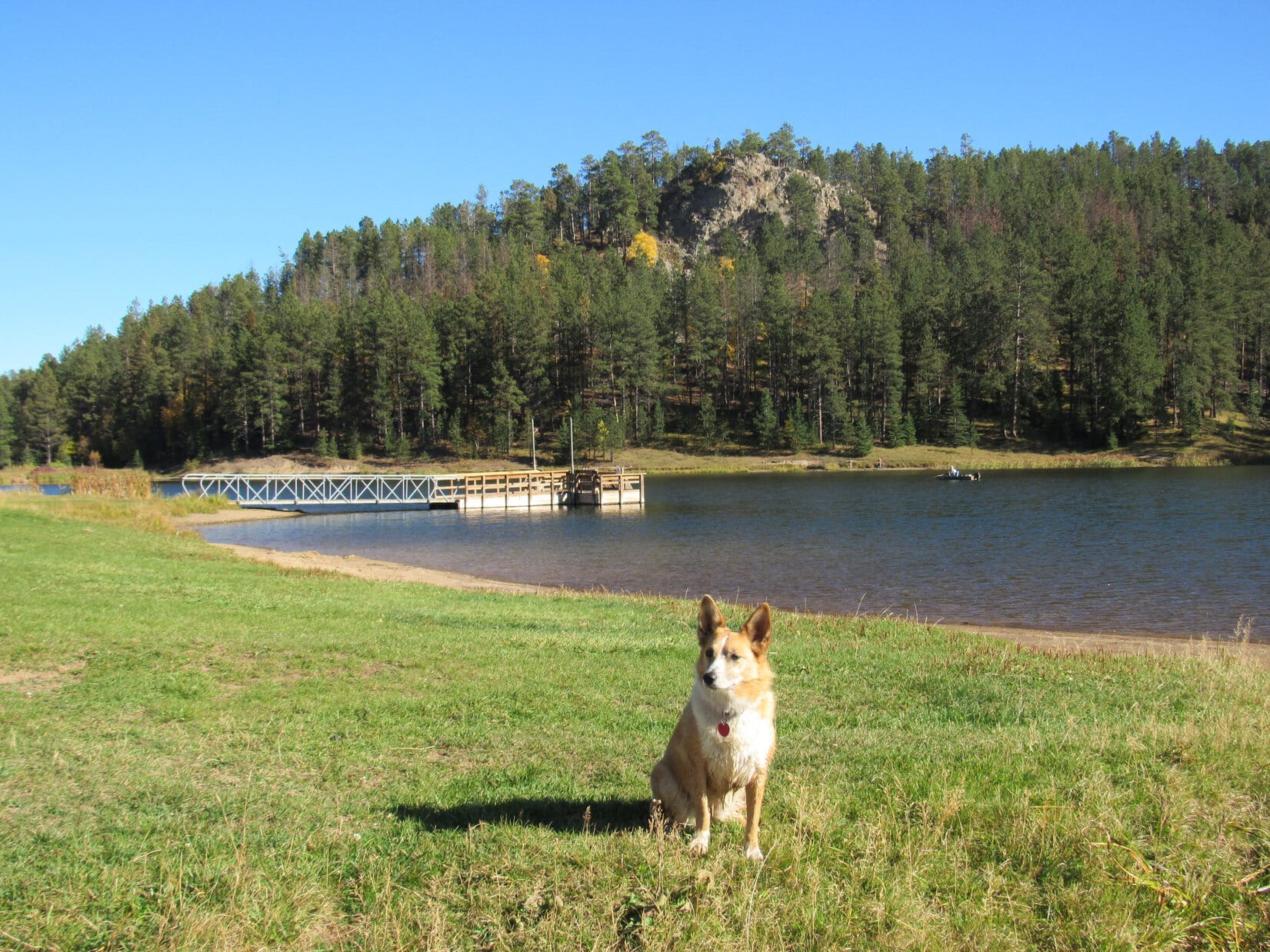
The next morning, Lupe, Sandy and SPHP went down to take a look at Kabekona lake. The lake looked wonderful! It was going to be a beautiful day! Lupe would only have half of the afternoon and this one evening before sunset to enjoy the lake, though. The rest of the day she would be stuck in the G6. Tomorrow she would be headed home again.
Lupe checks out Kabekona Lake early on 10-2-16. It was going to be a beautiful day at the lake!Kabekona Lake is SW of much larger Leech Lake in N central Minnesota. Photo looks NE.
It was an amazingly warm day for northern Minnesota in early October. During church, Lupe was confined to the G6 with the windows rolled down as far as possible without allowing her a possible escape route. She had plenty of water to help her stay cool. She would be bored, but fine.
After church, SPHP took Lupe for a short walk to a small lake nearby. Lupe was soon back in the G6, though, until social hour was done. SPHP brought Lupe a pastry from the church meant for social time attendees. Lupe wanted to go back with SPHP into the church, since SPHP had neglected to bring her any coffee, but SPHP wouldn’t hear of it.
A little after noon, social hour ended. Now it was time to go to the cemetery for a short ceremony for Connie. The cemetery wasn’t far away. Fortunately the road went right by a field full of black cows and Canadian geese. Lupe had an exciting, if brief, respite from boredom barking furiously at the cows.
Post ceremony at the cemetery, a luncheon was held back at the church. Lupe was still stuck in the G6. However, she did receive a much appreciated ham and cheese sandwich, plus another pastry, to ease both hunger and the monotony of confinement.
Lupe with flowers for Connie.
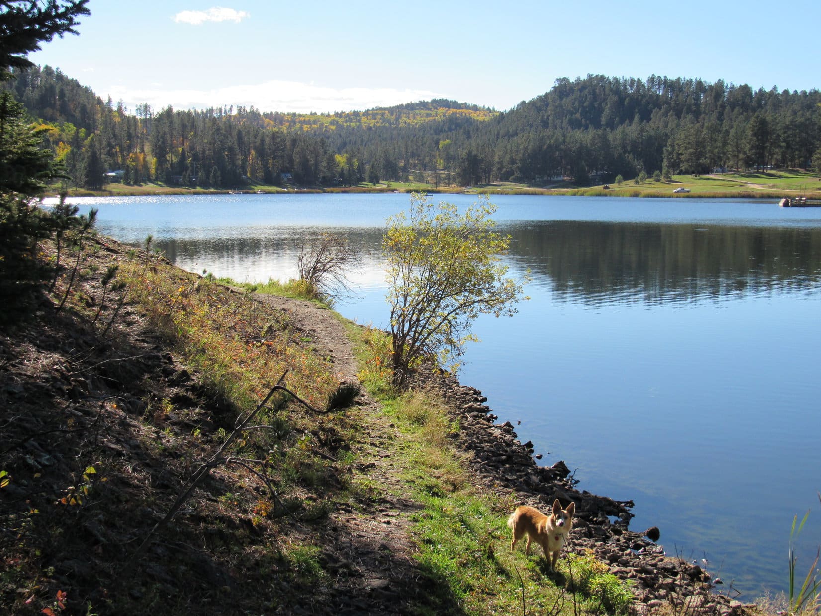
It was after 2 PM by the time Lupe was back at the cabin. Finally, she could go exploring outside. Was she ever ready! The Carolina Dog charged through the N woods, nose to the ground, delighted to be free again.
Lupe bounded around the cabin. She went with SPHP down to the dock for another quick look at Kabekona Lake. She explored the driveway and woods out to County Road No. 37.
Lupe at the Kabekona Lake cabin.Cabin life at Kabekona Lake in northern Minnesota is awesome! This message has been approved by an American Dingo.Lupe at the cabin’s shed for boating equipment and supplies.On the dock.So, SPHP, will you take me boating? Pretty please?Lupe on the cabin’s driveway out to Country Road No. 37.Early October is a great time to be in the north woods of Minnesota! Fall colors are on display. Better yet, the mosquitoes are all dead!
After Lupe’s outdoor reconnaissance, it was time to go back to the cabin to pop the big question. SPHP asked John about the possibility of taking the boat out on the lake?
John didn’t say no, but as SPHP expected, the events of the past summer meant John hadn’t had the boat out on the lake even once yet this year himself. There was a long list of tasks to accomplish to get the boat and motor ready for launch. Lupe wouldn’t get to spend much time actually on the lake. Nevertheless, SPHP was prepared to spring into action, when John made another suggestion.
Why not take the canoes instead of the boat? John had a canoe, and there was another one that could be borrowed at the cabin where Sandy and Lib were staying. That made more sense. It was a calm day with hardly any waves on the lake. The canoes would be fun, and would require almost no prep time at all! The plan was set. John went with Lupe and SPHP to launch the first canoe.
Soon Lupe was in the canoe out on Kabekona Lake! John and SPHP paddled over to the neighbor’s dock. SPHP climbed up a short ladder onto the dock intending to go get the second canoe. SPHP had barely reached the top of the ladder, when suddenly Lupe decided she wasn’t getting left behind. She launched herself out of the canoe!
Of course, Lupe didn’t realize the canoe would tip as she made her leap for the dock. Consequently, she didn’t jump quite high enough. For a fraction of a second, she clung to the edge of the dock trying to dig her claws in and scramble up, but she couldn’t. Lupe plunged back into Kabekona Lake sinking beneath the surface!
Now Carolina Dogs, at least this Carolina Dog, are not water dogs. Although Lupe likes wading in puddles and streams, and even laying down in them, SPHP has almost never seen Lupe swim. Maybe it was because of her first swimming experience.
When Lupe was 3 months old, on her first trip to the park, Lupe had hurled herself for no apparent reason into Rapid Creek. Of course, the tiny puppy sank far below the surface. SPHP was on the verge of wading in to save her. However, Lupe popped back up to the surface and swam against the current for shore, managing to extricate herself all on her own.
That first experience must have been quite a shock, though. Puppy Lupe had had no idea she would sink and start to drown. It was March. There was 6″ of snow on the ground. The water in the creek couldn’t have been much above freezing. Ever since then, Lupe has carefully avoided water that’s over her head.
Did Lupe even remember how to swim? SPHP peered anxiously into Kabekona Lake. Lupe did swim back up to the surface! She was doing the Dingo paddle for all she was worth, but she was confused. She swam around to the wrong side of the canoe where she couldn’t see the near shore.
SPHP called to Lupe and encouraged her to come. She swam back around the canoe again, and headed for shore. When she reached it, she released a great spray of water as she shook herself off. Despite her unexpected baptism in Kabekona Lake, Lupe was fine. She went with SPHP to launch the second canoe.
Before long, Laura and Sandy joined Lupe’s canoe fleet crew as paddlers. Laura went with John, and Sandy with Lupe and SPHP. It was sunny and warm. Lupe dried off quickly. She was quite content to stay in the canoe.
John and Laura in Canoe No. 1 of Lupe’s fleet.Sandy and Lupe in Canoe No. 2.Lupe’s canoe fleet headed for Preacher’s Point for no particular reason, other than to relax and enjoy the outing.John and Laura again, having a good time.Meanwhile, back at Canoe No. 2, Sandy was having fun, too. Lupe was still getting used to life as a sea dog. She was careful not to leap out of the canoe a second time.
There was no particular goal other than to paddle around lazily enjoying the day. Preacher’s Point along the SE shore of Kabekona Lake became the canoe trip’s destination by default.
After going a bit beyond Preacher’s Point, Lupe’s canoe fleet turned around and headed back for John’s cabin. There was no rush, just a leisurely paddle. Over two hours had gone by on the lake by the time the tiny fleet arrived back at the dock. John, Laura and Sandy were done for the day.
However, Lib hadn’t gotten a chance to be out on the lake yet. She joined Lupe and SPHP for a one canoe sunset cruise back to Preacher’s Point. The water was glassy smooth.
Sea dog Lupe enjoys the ride while Lib paddles.Lib near Preacher Point on Kabekona Lake.
On her second return trip from Preacher Point, Lupe was sailing toward the now setting sun. Her afternoon and evening on Kabekona Lake was almost over. The canoes had been a great idea. Even so, the hours had flown by fast.
Sunset from Kabekona Lake.Evening glow.The colors fade.
By the time it was all over and the canoes were put away, there wasn’t much light left at all. Lupe and SPHP took one last look at Kabekona Lake from the dock before heading to the cabin for supper.
Lupe on the dock again at dusk. Sea dog Lupe, like most sailors, was glad to be back on terra firma on shore leave.
Supper was well underway in the cabin by the time Lupe and SPHP appeared. The evening was spent in pleasant conversation, except for a brief altercation between Blackie, the jet black cat, and Lupe.
Apparently Blackie resented Lupe getting too close to his dinner bowl. Blackie let her know it in no uncertain terms. In return, Lupe made it clear that American Dingoes have no intention of being bossed around by mere cats. Fortunately, a truce based on mutual understanding was reached in two seconds.
The next morning, it was already time to say good-bye. Laura had left well before dawn to catch a plane. Sandy and Lib departed right after breakfast. A little while later, it was Lupe and SPHP’s turn to hit the long road home.
Lib and Sandy say good-bye.Joyce and Lupe with Claire looking on from the table.John & Joyce with Lupe.John shares a nugget of Norwegian philosophy.Claire and Joyce bid Lupe farewell.
Day 4 of Lupe’s summer of 2016 Dingo Vacation to the Canadian Rockies, Yukon & Alaska.
Well, Looper, how about we go see Lake Louise again before hitting the trail? Lupe was all for it, which was a good thing, since SPHP would have pretty much insisted on it. The view of snow-clad Mount Victoria(11,375 ft.) from Lake Louise is among the most beautiful and famous scenes in the Canadian Rockies.
The stroll down the trail from the upper parking lot to the boat house where they rent out canoes took only a few minutes. Suddenly, Lupe was back at Lake Louise for the first time since her summer of 2014 Dingo Vacation over 2 years ago. The tranquil, turquoise lake was as gorgeous as ever. Maybe there was a little less snow on Mount Victoria, but it was still an awesome scene.
Lupe arrives near the Lake Louise boat house early on this cool, clear morning.Mount Victoria from Lake Louise. Photo looks SW.
It was still relatively early (7:11 AM, 39°F). No one was out on the lake yet, although the usual crowd from Chateau Lac Louise was already gathering to admire the scene. Lupe and SPHP ambled over closer to the grand hotel. See that mountain, Loop? That’s Fairview Mountain(8,986 ft.) where you’re going today!
Fairview Mountain, seen here from Lake Louise, was Lupe’s main peakbagging objective for the day. Photo looks SSW.
Lupe posed for a photo from the shore of Lake Louise with Fairview Mountain in the background. A couple minutes later, when she jumped up on a low rock wall for another shot of Mount Victoria, tourists seemed to think it was quite a trick. Lupe basked in love and admiration. Cameras clicked like she was about to hold a press conference.
When Lupe leapt up on this low rock wall for another shot of Mount Victoria beyond Lake Louise, tourists seemed to think she had performed quite a feat.
Before the Carolina Dog could address her new fans with any long-winded speeches, SPHP led her away. After all, she had a mountain to climb! Lupe and SPHP headed for the Saddleback Trail, which splits off of the short path between the boat house and upper Lake Louise parking lot.
The Saddleback Trail begins climbing through a dense forest at a moderate to fairly steep pace. For quite a distance, there’s little to see except trees. After 0.4 km or so, Lupe passed by junctions with the Moraine Lake Highline trail and the Fairview Overlook trail. A sign said the Fairview Overlook trail went 0.7 km to the viewpoint, which presumably looks out over Lake Louise. A 2.3 km loop can be made back to the boat house.
The Fairview Overlook trail sounded like a nice little jaunt, likely rewarded with a great view of Lake Louise, but Lupe was going higher, much higher! Lupe and SPHP pressed on. Lupe had easily gone over half of the 3.7 km from Lake Louise to Saddleback Pass by the time she reached the first big opening in the forest. Now Lupe could see Saddle Mountain up ahead.
On the Saddleback Trail on the way to Saddle Pass. Here Lupe’s broken out of the mature forest to get her first clear view of Saddle Mountain up ahead. Photo looks S.
The slope up to Saddle Pass became steeper. Switchbacks appeared along the trail to help make the climb easier. As Lupe gained elevation, more glorious sights began to appear. Soon she could see the snowy summit of Mount Temple(11,614 ft.) poking up over Saddle Pass.
Mount Temple pokes up above Saddle Pass, an early indication of the glorious scenes in store for Lupe higher up.
As Lupe neared Saddle Pass, the trail gained elevation much more gradually than before. Sheol Mountain(9,117 ft.) and Haddo Peak(10,072 ft.) were in view directly ahead.
The trail climbed much more gently as Lupe neared Saddle Pass. Sheol Mountain (L) and Haddo Peak (R) were now in view.
When Lupe reached Saddle Pass, she came upon a sign clearly marking the side trail that goes the rest of the way up Fairview Mountain. The Saddleback Trail continued over the pass down into Sheol Valley, eventually reaching Paradise Valley far below.
Fairview Mountain from Saddle Pass. Lake Louise is on the other side of the mountain from here. Photo looks NW.This sign was along the Saddleback Trail as it headed for Sheol Valley a little beyond the side trail to Fairview Mountain. Sheol Valley and Paradise Valley are prime grizzly bear habitat.
Lupe and SPHP left the Saddleback trail to take the side trail up Fairview Mountain. The side trail passed through a short section of forest, then began a steep rocky ascent above tree line.
Looking SE down on Saddle Mountain (L) from the spur trail up Fairview Mountain. Saddle Pass and the intersection of the Saddleback Trail & Fairview Mountain Trail are seen at the lower R.
There was a fair amount of loose rock on the steep, narrow trail, but Lupe had no problem climbing up. She had plenty of opportunity to relax and enjoy the views while SPHP frequently paused for air. Lupe followed the trail all the way to the summit of Fairview Mountain. Magnificent views were in every direction, but Mount Victoria was the first splendor to attract the eye.
Lupe reaches the summit of Fairview Mountain! Mount Victoria is in view beyond her. Photo looks SW.Lupe up at the NE end of the Fairview Mountain summit. Photo looks NE at peaks of the Canadian Rockies on the other side of the Bow River valley.
Despite the splendid mountain scenery all around, a different view caught and held Lupe’s attention. A chipmunk was only a few paces away right here at the very top of Fairview Mountain!
While SPHP gazed at scenery, this chipmunk kept Lupe entertained up on Fairview Mountain! Mount Victoria in the background. Photo looks SW.Apparently the chipmunk appreciated a grand view, too, and was able to earn a living up on Fairview Mountain panhandling from visitors. Haddo Peak(10,072 ft.) (L), Mount Aberdeen(10,358 ft.) (Center – look straight down to see the chipmunk), and Mount Lefroy(11,293 ft.) (R) are in view here.Lupe and the chipmunk stare each other down.
The nimble chipmunk was a world class, lightning fast, scrambler. Lupe stared helplessly at the enticing Dingo treat. Meanwhile, the chipmunk pondered how to get safely past Lupe to plead for a handout. During the impasse, SPHP admired the planet from this terrific vantage point, occasionally interrupting Lupe’s reverie to demand that she pose for the camera.
Mount Daly(10,328 ft.) (Center) with the Bath Glacier below it. Photo looks NW with help from the telephoto lens.Mount Hector(11,135 ft.). Photo looks N using the telephoto lens.Looking down on Saddle Mountain (lower L). The Bow River valley is seen beyond it. Sheol Valley leading down into Paradise Valley is in view at the lower R. Photo looks SE.Haddo Peak (L), Mount Aberdeen (Center), Mount Lefroy (R of Center), and part of Mount Victoria (R). Photo looks SW.Mount Victoria. Photo looks SW.Mount Victoria with a little help from the telephoto lens. Photo looks SW.A closer look at Haddo Peak (L), Mount Aberdeen and the Aberdeen Glacier (Center), and Mount Lefroy (R). Photo looks SW.Mount Temple(11,614 ft.) is seen beyond Lupe on the L. Photo looks S from Fairview Mountain.Mount Temple (Center) is seen beyond Sheol Mountain (R). Photo looks S.The N face of Mount Temple. Photo looks S using the telephoto lens.Mount Aberdeen and the Aberdeen glacier (L) and Mount Lefroy (R). Photo looks SW.
For 20 minutes, Lupe and SPHP were alone at the top of Fairview Mountain. After that, a steady stream of climbers came and went. Lupe and SPHP met Krystin, a civil engineer from Calgary, who had once scrambled up Mount Temple. SPHP was mightily impressed, but Krystin said lots of people do it, although certain moves are required going up a band of cliffs.
Scrambling up Mount Temple didn’t sound like anything Lupe and SPHP could tackle. Lupe settled for having her picture taken with Krystin.
Krystin & Lupe on Fairview Mountain with Mount Temple in the background on the L. Krystin, a civil engineer from Calgary, had once scrambled up Mount Temple. Photo looks S.
People came and went. SPHP chatted with Krystin and a few others. The chipmunk stuffed its cheeks with peanuts, raisins and granola offered by the crowd, unmolested by Lupe. Conditions were perfect for hanging around enjoying the stupendous views!
Looking down on part of Lake Louise. Photo looks NW.Mount Victoria again. The Plain of Six Glaciers trail on the NW side of the valley below leads up to the base of Mount Victoria and a view of the Death Trap. Lupe took the Plain of Six Glaciers trail on both her summer of 2013 and 2014 Dingo Vacations. It is another trail in the area very much worth exploring, and sports a tea house along the way. Photo looks SW.The summits of Mount Aberdeen (L) and Mount Lefroy (R) using the telephoto lens. Photo looks SW.A final look at Mount Victoria from Fairview Mountain. Photo looks SW.
After more than 2 wonderful hours on Fairview Mountain, it was time for Lupe to get moving again. SPHP intended to simply follow the spur trail up Fairview Mountain all the way back down to Saddle Pass. Somehow though, before getting even 0.25 of the way down, SPHP realized Lupe was off the intended trail and on some kind of steep shortcut.
Lots of others had come this way, too, but the shortcut didn’t really save any time. The very steep “trail” eventually evaporated in a jumble of boulders. When Lupe and SPHP finally reached the Saddleback Trail again, Lupe had to take it back up to Saddle Pass. Lupe wasn’t ready to return to Lake Louise quite yet! She was going to climb Saddle Mountain, too.
SPHP looked for a side trail off the Saddleback Trail leading to Saddle Mountain, but found none, despite there being one on the maps. Lupe and SPHP finally just headed into the forest toward the mountain. As Lupe climbed Saddle Mountain’s W ridge, she did come to a faint, braided trail among the rocks.
Lupe climbing the W ridge of Saddle Mountain. Although she found a faint trail, most of the way up was simply an easy scramble among rocks and boulders. Photo looks E.
The summit ridge on Saddle Mountain was hundreds of feet long NE/SW with high points toward each end. Lupe arrived first up at the SW end where there was a big cairn. Although Saddle Mountain isn’t nearly as high as Fairview Mountain, it did offer beautiful views farther up Paradise Valley.
Lupe arrives on top of Saddle Mountain. For some indiscernible reason the American Dingo had a sly look on her face. Beyond her are Mount Temple (L), a view farther up Paradise Valley, and part of Sheol Mountain (R). Photo looks SSW.The upper end of Sheol Valley (Center) with the top of Mount Victoria looming over the ridge. The junction of the Saddleback trail and Fairview Mountain trail in Saddle Pass is seen to the R of Lupe. Sheol Mountain is on the (L), with Haddo Peak (L of Center). Photo looks WSW from Saddle Mountain.Looking NNE along the summit ridge of Saddle Mountain. Mount Hector is seen in the distance on the (L).Fairview Mountain as seen from Saddle Mountain. The Saddleback Trail is seen far below leading to Saddle Pass toward the L. The very steep “trail” Lupe took down Fairview Mountain is seen faintly leading straight down toward the switchbacks on the Saddleback Trail right above Lupe. Parts of the Fairview Mountain trail are seen even more faintly zig-zagging down toward the forest on the L. Photo looks NW.
Since the high point near the NE end of the summit ridge appeared to be slightly higher than the one near the cairn at the SW end, Lupe had to go over there to reach the true summit of Saddle Mountain. By the time she got there, Lupe and SPHP were no longer entirely alone. Another climber had appeared back at the cairn.
Lupe at the true summit of Saddle Mountain. Photo looks SW at Sheol Mountain (L) and Haddo Peak (R).Haddo Peak (L) and Mount Victoria (R) from the true summit of Saddle Mountain. Photo looks WSW.The little turquoise blue gem at the base of Mount Temple is Lake Annette. Lupe had taken the Paradise Valley trail to Lake Annette on 7-22-13 during her summer of 2013 Dingo Vacation. Photo looks S.Mount Temple, Lake Annette and Paradise Valley from Saddle Mountain. Photo looks S.Mount Victoria from Saddle Mountain using the telephoto lens. Photo looks WSW.Summit of Mount Temple using the telephoto lens. Photo looks S.
The other climber was gone by the time Lupe returned to the cairn at the SW high point. Lupe and SPHP spent a fabulous 30 minutes in solitude on Saddle Mountain. Then it was time to begin the return trip to Lake Louise.
Chateau Lake Louise from Saddle Mountain. Icefield Parkway Hwy 93 winds its way N past Mount Hector in the distance. Photo looks N.
It was almost dinner time for the American Dingo by the time she was back at the G6 (5:27 PM, 78°F). Instead of eating right away, though, Lupe and SPHP left Lake Louise heading N on Hwy 1 to Icefields Parkway Hwy 93.
Lupe arrived at the picnic ground on the E shore of lovely Bow Lake in time to have her evening meal there. By then the sky had clouded up. Although the mountaintops were no longer in view, the gloomy sky soon caused everyone else to depart. Lupe and SPHP had Bow Lake to themselves.
Tomorrow, Lupe would continue N to more adventures in the Canadian Rockies, hoping for a break in the clouds. In the meantime, though, Lupe dined and relaxed listening to gentle waves breaking on the shore of Bow Lake.
SPHP parked the G6 at the intersection of USFS Roads No. 134 and No. 626.1F (9:08 AM, 64°F). Lupe leaped out. She seemed surprised. Yeah, Loop, it has been a while, but summer is over. It’s time to resume your Black Hills expeditions again! Lupe was all in favor of that. Soon she was running through the forest sniffing madly, while SPHP struck out along No. 626.1F.
The road went NW a short distance before turning SSW. Near the turn was a big mud puddle off the W side of the road. The leaves of the aspen trees beyond the puddle were turning yellow, contrasting nicely with the green pines, murky brown water of the puddle, and clear blue skies. Come on over here, Loopster! Fall colors are going to be near their peak today. Let’s get a picture.
Lupe at the first big mud puddle she reached along USFS Road No. 626.1F. Lupe would see plenty of golden aspens this day, since fall colors were near their height in the Black Hills.
Lupe passed more mud puddles as she continued SSW along USFS Road No. 626.1F. The puddles were of little interest for her, except as occasional sources of mineral water. Lupe was far more interested in trees, specifically the exciting possibility that they might contain squirrels! She dashed through the forest, frequently stopping to check out the most promising prospects.
Lupe engages in one of her favorite pastimes, checking trees for squirrels.
In addition to her squirrel objectives, Lupe also had several peakbagging objectives for the day. The first one was Citadel Rock(5,480 ft.), located over 2.5 miles SW of the G6. Lupe’s route, though, was going to be circuitous and considerably longer.
Lupe followed USFS Road No. 626.1F for a couple of miles to an intersection with No. 626.1 at a point a mile E of Citadel Rock. Instead of immediately turning W, Lupe and SPHP followed No. 626.1 going NW to No. 626.1A. No. 626.1A subsequently went W, and then SW, to No. 626.1C.
No. 626.1C wasn’t really even a road any more. It was overgrown with weeds, and blocked at many points by mounds of dirt and rock that had scooped up out of the roadbed for that very purpose. Lupe and SPHP finally got a glimpse of Citadel Rock high above while heading S up a valley on No. 626.1C. The road passed to the W of Citadel Rock before curling E and climbing to the top of a ridge.
From the ridge it was possible to get the first halfway decent look at Citadel Rock, which was now 0.25 mile N.
Citadel Rock juts up above the trees. Photo looks NNW.
A single track trail led NNW through the forest following the ridgeline toward Citadel Rock. Lupe soon reached the base of the rock formation.
Lupe reaches the base of Citadel Rock. Photo looks NW.
Citadel Rock was only about 40 feet higher than the rest of the ridge, but the walls of the rock formation were nearly vertical. Although experienced rock climbers would have no problem reaching the top, Lupe could only get part way up the S face.
Lupe and SPHP went counterclockwise around the base of Citadel Rock looking for an easier way up.
Looking up at Citadel Rock from the ESE.Below the N face.The N face of Citadel Rock was even higher and more vertical than the S face.
There was no route up from the E. As Lupe proceeded around the shady N face, it began to dawn on SPHP that maybe there wasn’t a way up for the American Dingo. The N face was even more vertical than the S face had been.
By the time Lupe was around to the SW face, things were looking better. However, after some initial investigation, SPHP didn’t think Lupe could get up from here either.
The W face.The SW face. At first SPHP thought Lupe might be able to climb up the steep slope seen on the R and find a route to the top, but further investigation proved discouraging.
Lupe went clear around Citadel Rock, but found no safe way up for a Carolina Dog.
To SPHP, it seemed just ridiculous. Lupe had found a way up many a towering, impressive peak on her Summer of 2016 Dingo Vacation. In fact, she had ultimately succeeded in reaching the top of every peak she attempted. Now, here, back in the Black Hills of South Dakota, there was no way up to the top of the very first little peak she tried!
Back at the S face of Citadel Rock, Lupe and SPHP made one last attempt to find a way up. She could get higher here than anywhere else, but there simply wasn’t a reasonably safe route to the top.
Lupe stands as high up on Citadel Rock as she was going to get. Photo looks WNW.
Well, Loopster, looks like you are either going to have to sprout wings or leave this one to the rock climbers. Although SPHP was a bit disappointed, Lupe took it all in stride. She took a break, enjoying Taste of the Wild, water, and half of SPHP’s chocolate coconut granola bar.
Lupe was more interested in what was going on in the forest than in reaching the top of Citadel Rock.Loop relaxes after circumnavigating Citadel Rock. She didn’t get to the top, but was in fine spirits nevertheless.
Lupe had a couple more peakbagging goals for the day after Citadel Rock, but they were far enough away so she needed to return to the G6 to get closer to them. Lupe and SPHP gave up on Citadel Rock, and followed the trail along the ridge back to the S. Instead of returning to the G6 the way she had come, Lupe continued S up onto a larger ridge before turning E.
A single track trail wound along the bigger ridge past scenic aspens before continuing on down to USFS Road No. 626.1F. Lupe reached the road well S of its junction with No. 626.1 where she had left it earlier.
Colorful aspens decorated the big ridge S of Citadel Rock. Photo looks SE.
Loop on her way down to USFS Road No. 626.1F again. Terry Peak(7,064 ft.) is seen in the distance on the R. Photo looks SE.
Lupe followed USFS Road No. 626.1F all the way back to the G6 (1:48 PM, 72°F). Despite failure at Citadel Rock, Lupe still had two more peakbagging goals – Beartown Hill and The Needles. After a short drive, she would start first for Beartown Hill from the intersection of USFS Roads No. 222 and No. 222.1N (2:16 PM, 72°F).
Getting to the top of Beartown Hill(5,880 ft.) took hardly any time at all. Lupe gained only a little elevation from where she started. She followed USFS Road No. 222.1N less than 0.25 mile NE to reach two high points a little E of the road that appeared to be candidates for the true summit of Beartown Hill. The high points were separated by perhaps 400 to 500 feet. Lupe visited both.
Lupe on the first high point that was a candidate for the true summit of Beartown Hill. Photo looks NE.Lupe at the second candidate for the true summit of Beartown Hill. The summit area was so large and flat that it hardly seemed like Lupe was on a mountain at all. Photo looks N.
Well, that was easy. Too easy, actually! The summit area on Beartown Hill was so flat and wide it hardly seemed like Lupe was even on a mountain. At least going to Citadel Rock had involved some elevation gain, even though Lupe hadn’t been able to reach the top. Now, here she was at the top of Beartown Hill with virtually no effort. So far, Lupe had enjoyed nice outings in the woods, but as a peakbagging day, the results were not inspiring.
Only one peakbagging goal remained – The Needles(5,880 ft.). In the Black Hills of South Dakota, the area normally referred to by locals and tourists alike as “The Needles” is in the southern Black Hills in NW Custer State Park. That area includes the Cathedral Spires(6,840 ft.) as well as other granite spires commonly viewed from along The Needles Highway (Hwy 87). The Needles in Custer State Park are a rather famous tourist attraction.
However, The Needles that Lupe intended to climb this day, was in the far NW part of the Black Hills of South Dakota. In fact, SPHP had never even heard of this The Needles before noticing it labeled on an old USFS map. Was it another grouping of granite spires? Was it just another mountain? SPHP had no idea, but Lupe was going to find out. This The Needles was located about 2 miles NNE of Beartown Hill.
From the second high point on Beartown Hill, Lupe and SPHP returned to USFS Road No. 222.1N. Quite encouragingly, the road continued NNE in the general direction of The Needles. As Lupe followed the road, SPHP was hoping it might continue all the way to The Needles. No such luck. The road soon reached a dead end.
Lupe left the road, temporarily turning NNW to stay up on a ridge, which hopefully would eventually lead to The Needles. At first, the terrain along the ridge seemed encouraging, but after 0.25 mile or so, Lupe came to a dense part of the forest. Ahead to the N, the ridge seemed to end, dropping steadily down a forested slope as far as SPHP could see. Other ridges and valleys were partially in view to the NW and NE.
SPHP consulted the maps. To get to The Needles, Lupe needed to stay up on the ridge, although she would have to drop temporarily down into a couple of saddles along the way. Although the topo map made the ridge look like an easy thing to follow, in the real world, the terrain seemed confusing and more complicated. Already, SPHP wasn’t quite sure Lupe was even on the right ridge.
Staring down the densely forested slope, SPHP lost confidence. There weren’t many landmarks around. It looked like it would be easy to get turned around and lost in this territory. If it had been earlier in the day, that wouldn’t have been too big a deal, but it was already close to mid-afternoon. Lupe waited expectantly, wondering what the hold up was, while SPHP pondered.
SPHP wasn’t at all confident that Lupe would even be able to climb The Needles, assuming she could find them. She certainly couldn’t climb any of the vertical granite spires called The Needles in Custer State Park. Maybe it didn’t make any sense to continue. On the other hand, if Lupe didn’t climb The Needles, Expedition No. 175 was going to be pretty much a complete peakbagging dud, however much Lupe enjoyed her romp in the woods.
Sigh. We better turn back Loopster, I don’t like the looks of this, not this late in the day. How would you like to go see Iron Creek Lake instead? Lupe barked enthusiastically. She was fine with Iron Creek Lake or wherever, as long as SPHP started moving again. Lupe wanted action, not all this indecisive dawdling around! Lupe and SPHP turned around and headed back to the G6 (3:20 PM, 72°F).
A short drive brought Lupe to Iron Creek Lake, a small lake hidden at the end of a gravel road (3:36 PM, 70°F). There were cabins on private property around the W end of the lake. Along the N shore was a store (closed for the season), a boat launch, small beach and a dock. The lake looked great to Lupe! She was thirsty. Lupe immediately ran down to Iron Creek Lake for a big thirst-quenching drink.
Lupe dashed down to Iron Creek Lake for a drink. Photo looks SW.Iron Creek Lake. Photo looks SW.
Although Iron Creek Lake looked like it might be quite a busy place in the summer, it was pretty quiet this time of year. A few people were fishing along the shore, and one was fishing from a small boat trolling slowly around the lake. Other than that, no one seemed to be around.
The little lake was quite beautiful, sparkling in the sunlight. A path led around the E end of the lake. Lupe and SPHP took a pleasant stroll not only around the E end, but clear around the lake. The people Lupe passed by were having some luck catching rainbow trout. Lupe saw a few ducks fly off, and even saw a family of ducklings paddle away.
Lupe on the N shore of Iron Creek Lake. Photo looks E.Lupe along the E end of the N shore. Cattails grew in profusion around much of the lake. Photo looks WSW.Lupe stands on the dam at the E end of Iron Creek Lake. There are no natural lakes in the Black Hills. Photo looks WNW.Looking WNW from the SE corner of Iron Creek Lake.Looking W.Ducklings on Iron Creek Lake.
Although Lupe and SPHP were in no hurry, it took less than 40 minutes to stroll all the way around Iron Creek Lake (4:14 PM, 70°F). By then, SPHP had a new idea. Maybe Lupe could still climb The Needles? Although The Needles was 2 miles N of Beartown Hill, there was another possible approach from a much closer starting point. USFS Road No. 130 passed only a little over 0.5 mile to the E of it.
Earlier, SPHP had rejected the notion of climbing The Needles from the E. The topo map showed Lupe would have to leave the road, drop down into Beaver Creek canyon and find a way across the creek, before even attempting to ascend The Needles. SPHP had thought that the E side of the canyon might be a cliff from the close spacing of the contour lines on the topo map, or that Beaver Creek might be difficult to cross.
What if these obstacles really weren’t that bad? It was now pretty late in the day, but why not at least take a look? Lupe and SPHP left Iron Creek Lake (4:14 PM, 69°F) determined to at least drive far enough along USFS Road No. 130 to see if there was any realistic possibility of climbing The Needles from the E.
Initially, the drive N along USFS Road No. 130 was not encouraging. Although the road was on high ground E of Beaver Creek canyon, the forest hid any views to the W. SPHP parked the G6 briefly at a junction with USFS Road No. 222.1D, intending to follow it W at least far enough get a view of the canyon. Lupe, however, refused to budge from the G6.
SPHP reviewed the maps again. Maybe the Carolina Dog was right. Another mile N, and USFS Road No. 130 would be at its closest point directly E of The Needles. SPHP got back in the G6. OK, we’ll try it your way, Loop! Lupe grinned, but said nothing as SPHP started driving slowly N again.
After going more than 0.75 mile, two hills close together could be glimpsed off to the W. The view didn’t improve much as SPHP continued driving N. At 1.25 miles, SPHP parked the G6 along USFS Road No. 130 at a point already a little N of the two hills. Lupe again refused to leave the G6, preferring to wait until SPHP returned with a quick scouting report.
Loopster, come on out! This must be it. That highest hill toward the W has to be The Needles. Let’s see if we can get there. Lupe wasn’t sure this was a good idea, but with a little coaxing, she hopped out of the G6. It was already 4:50 PM (69°F). Rough terrain and lack of daylight might prove an insurmountable combination of obstacles. Lupe and SPHP struck off to the W through the forest, regardless.
Almost immediately, the ground started falling off more and more steeply. Lupe descended rapidly into the Beaver Creek canyon. SPHP hoped she wouldn’t cliff out, and she didn’t. After losing nearly 200 feet of elevation, a creek bed of light gray rocks appeared below. It was totally dry. Lupe and SPHP were soon down there, following the creek bed N.
The creek bed was rough terrain full of stones. The canyon made a sharp turn to the W, after Lupe had followed it only a few hundred feet N. If anything, the creek bed was even rockier after turning W. Lupe and SPHP abandoned the creek bed and scrambled up the opposite bank. Lupe headed SW through forested territory full of brambles, gaining elevation as she went.
For a while, SPHP wasn’t certain if Lupe had crossed Beaver Creek, or if she had only made it over a dried up tributary in a side canyon. As Lupe continued gaining elevation steadily, though, it slowly became apparent that she actually was across Beaver Creek. That was encouraging!
Lupe soon got more good news. She got out of the worst of the brambles, and reached the top of a low forested ridge. The two hills to the W were in view again, closer than before. The S hill was lower than the N one, but they weren’t too far apart. The ridge Lupe was on rose toward the SW. A check of the topo map showed that Lupe should probably follow this ridge toward the lower hill.
The ridge went SW farther than SPHP expected. Finally, Lupe found a saddle leading W toward the two hills. Lupe crossed the saddle and started climbing. Near the top, the climb up the S hill was tougher than expected. A combination of large boulders and deadfall timber made the going very slow.
By the time Lupe reached the top of the S hill, it was decision time. The N hill wasn’t far away, but the sun was low in the sky. Clearly, going on to climb the N hill meant Lupe wouldn’t be able to get back to the G6 before dark.
Nope! No way Lupe was turning back! As long as Lupe could get halfway back before dark, SPHP was confident the terrain was distinctive enough so that Lupe wouldn’t get lost. Lupe and SPHP hurried down into a shallow saddle leading to the N hill. Soon Lupe was gaining elevation again. The climb was moderately steep, but without all the big boulders and deadfall that had slowed her down on the S hill.
It looked like Lupe didn’t have far to go to reach the top of the N hill. What would she find there? Would she be able to reach the summit? Was this hill really The Needles?
The sun was sinking, as Lupe reached a collection of medium-sized stones at the top of a very small summit area. And sure enough, there it was! A survey benchmark saying “Needles” was affixed to a rock next to the highest rocks on the mountain. Lupe had her first notable peakbagging success of the day!
The Needles survey benchmark. Finding this benchmark up at the top of the N hill confirmed that Lupe had really found and climbed The Needles, despite failure earlier in the day. Suddenly Lupe’s peakbagging efforts on Expedition No. 175 finally seemed successful and worthwhile.Lupe up on top of The Needles(5,880 ft.)! Photo looks N.Looking SW from The Needles summit. The small granite spires on the R likely gave the mountain its name, although they are tiny compared to the famous Needles in Custer State Park.
Lupe and SPHP stayed up on The Needles as long as the sun remained above the horizon. The mountain wasn’t particularly high or prominent. The views were nice, but not particularly impressive. Yet it was still fun to be here, up on a seldom visited remote outpost of the northern Black Hills – a remote outpost that had almost eluded Lupe on this beautiful early autumn day.
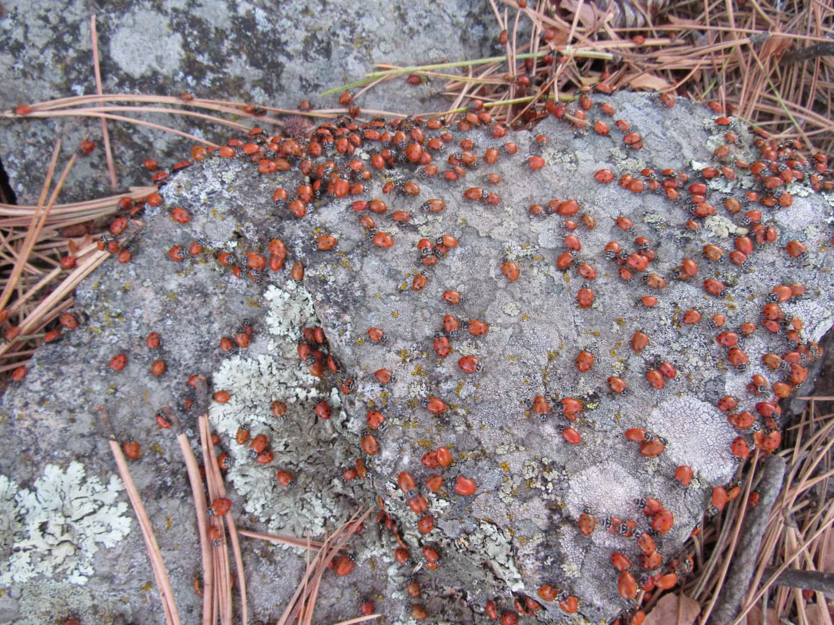
Ladybugs were having a major convention up on The Needles when Lupe came along.Lupe at the summit. The survey benchmark is in view below and to the R of her. Photo looks SSW.Lupe in the fading light on The Needles. Photo looks NNW.Looking NE up at the summit.Lupe just below the highest rock. She looks concerned, because she heard a single gunshot a moment earlier. Photo looks NE.
Before leaving The Needles, Lupe went down near the granite spires that likely gave the mountain its name. When the sun disappeared from view, it was time to go. Lupe and SPHP hurried through the darkening forest, bypassing the S hill to the E.
Lupe near the granite spires. Photo looks WSW.
Sunset from The Needles.
Stars were shining by the time Lupe made it back to the low ridge W of Beaver Creek. It was so dark out, SPHP had to bring out the flashlight. The batteries were dead! They had been dying for a long, long time. SPHP had been carrying spare batteries around for more than 2 years. Would they work? They did!
By the light of the little flashlight, Lupe and SPHP scrambled down a steep bank to the dry creek bed of Beaver Creek. Lupe was somewhere S of where she had crossed it on the way to The Needles. Climbing up the E side of the canyon, cliffs came into view above. Fortunately, there was a narrow passage between them. Lupe made it above the cliffs. The steep slope began leveling out.
Lupe and SPHP plunged E through the inky forest for a long way after the ground was almost level. Sooner or later Lupe had to come to USFS Road No. 130, no matter where she had crossed Beaver Creek. SPHP looked to the Big Dipper in the night sky to stay oriented. Suddenly the road appeared only a few feet away.
In darkness and silence, Lupe and SPHP enjoyed a surprisingly long march N beneath the faint glow of the Milky Way. When Lupe finally reached the G6, her Black Hills Expedition No. 175 adventures were over. (8:32 PM, 57°F)