Start – 9:09 AM, 68°F, Spring Creek trailhead of Centennial Trail No. 89
Half a dozen vehicles were at the Spring Creek trailhead off Sheridan Lake Road when Lupe arrived. Apparently the day was going to get off to a busy start, at least by the Carolina Dog’s standards.
Lupe didn’t mind having an opportunity to meet a few people and sniff with other dogs. They were all likely to be concentrated around this first part of the trail along Spring Creek and Sheridan Lake. She would have plenty of solitude soon enough. Loop was eager to get going, and was underway as soon as SPHP was ready.
The Spring Creek trailhead provides access to Flume Trail No. 50 and the 111 mile long Centennial Trail No. 89. A spur trail follows Spring Creek upstream for a mile to Sheridan Lake where intersections with both of the main trails are found. Spring Creek is one of the larger streams in the Black Hills. The upstream trek is easy and beautiful.
By Spring Creek only a short distance from the trailhead.
Several beam bridges cross Spring Creek on the way to Sheridan Lake. Before the first bridge a shortcut to the Dakota Point trailhead appears on the R. This seldom used side route is easy to miss, if not looking for it. The shortcut avoids the rest of Spring Creek and Sheridan Lake entirely.
Lupe wasn’t looking for a shortcut now. Water in all its forms lends beauty and tranquility to almost any scene. The American Dingo had plenty of time to take the scenic route. She skipped the shortcut and went on to the first bridge.
On the first beam bridge across Spring Creek. Lupe would cross a couple more of these bridges on her way to Sheridan Lake.
Lupe did meet several people and a couple of dogs, but only briefly. A fisherman hadn’t had any luck fishing Spring Creek. Although the sky was overcast, everyone was enjoying the unseasonably warm day.
On the second beam bridge.Crossing these beam bridges is fun!
The spur trail was practically level almost all the way to Sheridan Lake. Near the dam the trail became steeper, but not for long. Loop was soon up on the S end of the dam. She had reached Centennial Trail No. 89.
Lupe arrives at Sheridan Lake near the S end of the dam. Photo looks NNE.
Lupe could have taken Centennial Trail No. 89 SE along Sheridan Lake from here. Alternatively, Flume Trail No. 50 branches off just S of the dam. However, the plan was to explore the Centennial Trail N to the Brush Creek trailhead, a distance of nearly 8 miles.
The American Dingo trotted across the dam heading N. At the far end, a winding stone stairway led to the top of a small hill.
Looking S at the Sheridan Lake dam. The hill on the R is Bluelead Mountain(5,170 ft.) where Lupe had seen a mountain lion on Leap Day in 2016. The more distant higher hill R of Center is Calumet Ridge(5,601 ft.).E end of Sheridan Lake. Photo looks SW.
Leaving Sheridan Lake behind, Lupe crossed a footbridge over the Spring Creek outlet.
This footbridge spans the narrow chasm where Spring Creek flows out of Sheridan Lake. Lupe crossed it on her way to the Dakota Point trailhead.
After crossing this last bridge over Spring Creek, Lupe had nearly a mile to go on Centennial Trail No. 89 to get to the Dakota Point trailhead. This entire route was on an old road through the forest. For the first 0.5 mile, the road went N up a valley until it reached a saddle. At the saddle, the road leveled out and turned W the rest of the way.
No vehicles were at the Dakota Point trailhead. The road hike from Sheridan Lake to get here had been a bit dull. However, Lupe still had 6.8 miles to go to get to the Brush Creek trailhead, and the trail was about to get more interesting. The trail crossed a gravel road becoming a single track going downhill on the other side.
Being on the single track was more fun. The trail went both up and down in a forest that had been thinned. Overall, Loopster lost a little net elevation by the time she reached Sheridan Lake Road 0.5 mile NW of the Dakota Point trailhead.
After passing the Dakota Point trailhead, Centennial Trail No. 89 becomes a single track for 0.5 mile on the way to Sheridan Lake Road. Photo looks NW.
Once Lupe crossed Sheridan Lake Road, Centennial Trail No. 89 took her NW up a long valley. This was the start of a much more private and less traveled region.
Lupe had hardly gotten started up the valley when she crossed a tiny trickle of a stream. The day was quite warm, very warm if wearing a fashionable fur coat like Lupe was. The tiny stream featured a small, rather slimy green waterhole. The American Dingo was not shy about helping herself to a slimy drink, and a quick slimy, cooling bath.
Slime? What slime? This is great! Nice and cool!
Centennial Trail No. 89 followed an abandoned USFS Road up the long valley. The grassy road seemed like a part of nature.
Going up the long valley. Photo looks NW.
The trail continued NW or N following a maze of old roads. Most of this area was forested, but Lupe passed a few meadows, too. At one point she went by a large rock formation on the R. It was the only one, though. This wasn’t rough territory.
Lupe gained elevation steadily at a modest pace. A mile from Sheridan Lake Road she reached a minor crest. Beyond the crest the trail brought her to a large power line.
About a mile from Sheridan Lake Road, Lupe reaches a big power line. Centennial Trail No. 89 follows the power line for a couple hundred yards before disappearing back into the forest on the R. Photo looks NE.
Centennial Trail No. 89 turned NE here, following the power line for 200 yards before heading E back into the forest. Lupe quickly crossed a small saddle before losing elevation slowly as the trail entered a more open region. Stands of aspens were common.
After leaving the power line and crossing a small forested saddle, Lupe enters a shallow valley where aspens were common among the pines. Photo looks ESE.
Much of the Centennial Trail sees only light use. Trail maintenance is spotty. In many places trail markers are missing, have faded or fallen over. Unless some degree of alertness is maintained, it can be easy to miss turns. SPHP sensed Lupe might be approaching one of these places. The trail was going E or even SE. Somewhere around here, it would have to turn N again fairly soon.
The grassy road the trail followed took Loop well into the aspens before she reached the turn N. Fortunately, this turn was marked. Otherwise it would have been so easy to keep following the grassy road SE.
Centennial Trail No. 89 turns N (L) here. Fortunately, the turn is marked by an arrow on the brown wand (R). Photo looks ESE.
As soon as the trail turned N, Lupe began gradually regaining the nearly 100 feet of elevation she had lost on the way down into the aspens. She regained it all and more before reaching another saddle in a pine forest. This saddle was SE of High Point 5302 and SW of High Point 5331.
It was time for a short break. Small rock outcroppings a little SE of the trail seemed like a good spot. Lupe had water. She wasn’t interested in her Taste of the Wild yet, but was quite happy to help SPHP out with that chocolate granola bar.
Although there had been sections of downhill on the way here, none of them had been too significant. For the most part, Lupe had been gaining elevation. She was now at 5,200 feet, the highest point she would reach while actually on Centennial Trail No. 89 all day.
At the high point of Centennial Trail No. 89 between the Brush Creek trailhead and Sheridan Lake. Lupe’s at 5,200+ feet here. Photo looks N.
When break time was over, Lupe started the first significant downhill stretch she’d come to all day. At first, on the steepest part of the decline, Centennial Trail No. 89 followed an old road. Once Looper had lost 200 feet going generally N, the trail swung E while losing another 150 feet.
After losing more than 200 feet of elevation from the high point, Centennial Trail No. 89 leaves the road here to skirt the hillside on the L. Photo looks E.Although the Black Hills are full of deadfall timber resulting from a pine bark beetle infestation, Lupe came to very little deadfall on the portion of Centennial Trail No. 89 that she explored today. This short stretch was an exception. Photo looks ENE.
0.75 mile from the high point where Lupe had taken her short break, Centennial Trail No. 89 bottomed out. It now started up a valley that led NNE. Lupe was about to enter the Bald Hills, an area of grasslands covering 2+ square miles within the Black Hills National Forest. She soon arrived at a saddle E of Twin Sisters(5,244 ft.).
Centennial Trail No. 89 passes right by the Twin Sisters. The E Twin Sister is the hill seen here. Photo looks WSW.
The E Twin Sister is the highest, and sits along the edge of the Bald Hills. Centennial Trail No. 89 goes right by it. This was an opportunity for Lupe to get a little peakbagging in! Loop and SPHP left the trail and made the short climb to the top.
Loop arrives at the summit of the E Twin Sister. Peak 5800 is seen on the L. The lower grasslands are part of the area known as the Bald Hills. Photo looks WNW.Peak5800 is on the L. The most distant forested hill R of Center is the mountain Lupe knows as New Year’s Eve Peak(6,046 ft.). Photo looks WNW.
The summit of the E Twin Sister was a short ridge running N/S. Deadfall timber littered the entire N end, and part of the S end, too. A patch of ground right at the true summit was open and only a bit rocky. Many dead trees had fallen over, but enough dead and live pines were still standing to mar the views in most directions.
Still, this wasn’t a bad vantage point. Lupe could see a number of peaks she had been to before. She also enjoyed a commanding view of the Bald Hills to the E.
Five Points(6,221 ft.) (L of Center) is on the horizon. The nearest ridge beyond Lupe is the lower W Twin Sister. Photo looks SW.Lupe liked this commanding view of the Bald Hills. Photo looks E.
The temperature must have been in the 70’s °F. The physical exertion of following the trail and climbing E Twin Sister was enough to make it seem very warm. Lupe and SPHP were both ready for water and a longer break. The Carolina Dog thought maybe it would be best to eat the other chocolate granola bar right now before the chocolate melted. That seemed like a good idea, and the deed was done.
The heat made Loop and SPHP lazy. Twin Sisters was a nice spot with at least some views. Why not relax a bit? Lupe laid down next to SPHP. She enjoyed being petted while scanning the Bald Hills below for any signs of movement. A few insects buzzed by. The warm air and light breeze felt good when you weren’t doing anything.
SPHP woke up. The American Dingo was still right there. She hadn’t moved a muscle. The sky had been overcast when Lupe arrived up on Twin Sisters, but now it was sunny. That really had been a nice break, but it was time to get going. Loop and SPHP headed NE down toward Centennial Trail No. 89.
After a nice long break up on Twin Sisters, Lupe heads back down to Centennial Trail No. 89. Photo looks NE.Looking back up at the E Twin Sister from Centennial Trail No. 89. Photo looks SW.
Centennial Trail No. 89 headed NE losing elevation as it crossed the Bald Hills. It looked like it was going to go down a long valley, but instead curved E. The trail climbed again staying in the Bald Hills a little longer before turning N and heading for the trees. Before it reached the forest, Lupe took another look back at Twin Sisters.
Looking back across the Bald Hills toward Twin Sisters (L), Peak 5800 (Center) & New Year’s Eve Peak (R). Photo looks SW.
0.5 mile NE of Twin Sisters, Centennial Trail No. 89 entered the forest once more. Lupe lost elevation gradually over the next 0.5 mile. The trail rounded a ridge and came to a tiny Dingo-sized forest.
Approaching the tiny forest. Photo looks NNW.
After climbing through the tiny forest, Lupe reached a saddle where she crossed a gravel road. On the other side Centennial Trail No. 89 began losing elevation again. The Carolina Dog was now on the final stretch approaching Brush Creek.
Near the start of the final stretch leading down to Brush Creek. Photo looks N.I’ll have you know this was a very exciting part of the trail. I found a squirrel! Photo looks N.
Before long, Lupe was at Brush Creek. Brush Creek didn’t amount to much. Hardly a trickle. However, there were a couple of nice pools of water. The Carolina Dog was glad to see them!
I was so thirsty after barking at that squirrel!Maybe we should follow streams all the time now that it’s getting warm out? So nice to be able to cool off!
The Brush Creek trailhead was across a gravel road from Brush Creek. One vehicle was here, but no one was around. The trailhead featured a map and information about Centennial Trail No. 89.
Loopster at the Brush Creek trailhead.Centennial Trail No. 89 winds 111 miles from Bear Butte near Sturgis, SD to Wind Cave National Park in the southern Black Hills.Zoomed in a bit more on the map.History of Centennial Trail No. 89.
At the Brush Creek trailhead, Lupe was somewhere around 8.5 miles from where she’d started out at the Spring Creek trailhead this morning. This was far enough for one day, since she now had to go all the way back. When SPHP was done looking at the posted map and information about the trail, Lupe set off again. This time she was heading S.
By the time Loopster made it back to the Bald Hills, the sunny day had vanished. A thunderstorm was approaching out of the SSW.
A thunderstorm was approaching out of the SSW by the time Lupe made it back to the Bald Hills. The E Twin Sister is dead ahead. Photo looks SW.
Loop and SPHP left the trail to take a shortcut across the Bald Hills to Twin Sisters(5,244 ft.). The original plan had been to climb both the E and W Twin Sisters on the return trip, but with the storm approaching, Lupe would be lucky to beat it to just the E Twin Sister.
People were shooting guns somewhere off to the E not too far away. Lupe couldn’t see them, but the sound of gunfire so close by made her a nervous wreck. She wanted to find a place to hide, but SPHP urged her on toward the E Twin Sister.
Pasque flowers, the state flower of South Dakota, were blooming out on the Bald Hills.
When Loopster reached the summit of the E Twin Sister again, she felt better. The gunfire was far away now. She really wasn’t as safe as she thought, though. Trees swayed in a gusty S wind, light rain was falling, thunder rumbled, and occasional lightning flashes could be seen only a few miles away.
Back at the summit of E Twin Sister for the 2nd time today. Photo looks NW.Five Points on the horizon seen through light rain. Photo looks SW.Five Points(6,221 ft.). Photo looks SW.
Although the storm wasn’t bad yet, due to the lightning SPHP was eager to leave the summit almost as soon as Lupe arrived. All thoughts of climbing the W Twin Sister had gone out the window, too.
When SPHP started down, Lupe didn’t follow. She wanted to stay. She felt safe from the gunfire here, and apparently had fond memories of the earlier nap on E Twin Sister. Clearly, the Carolina Dog was hoping for a repeat performance.
Despite the storm, Loopster wanted to stay up here on E Twin Sister. She was looking forward to another nap!
Loopster still had a long way to go. Even if there hadn’t been a storm, there wasn’t time for another nap. SPHP coaxed Loop into returning to the trail.
The storm struck only a glancing blow. It rained, but never too hard. After a while the sun came out. The air was cool now. It was evening. The secluded trek along Centennial Trail No. 89 was wonderful. Loop saw deer and wild turkeys. She went on and on, sniffing happily.
Another storm came and went, striking another glancing blow. Lupe got wet, but not soaked. Near the end of the day, she took the shortcut leading down to the spur trail near the first bridge over Spring Creek. The sun was down and light was fading by the time Lupe was closing in on the Spring Creek trailhead again. It wasn’t dark when she arrived back at the G6, but would be soon. (8:06 PM, 52°F)
Time to head home for Alpo, and a night dreaming of days yet to come on Centennial Trail No. 89.
Evening on Centennial Trail No. 89, Black Hills of South Dakota, 4-29-18
Day 20 of Lupe’s 2017 Dingo Vacation to the Yukon & Alaska!
3:12 AM, 36°F – Already seems like there’s a bit of light. Lupe was out of her blankie. Pulled it back over her. Keep the puppy warm! Too early. Back to sleep.
4:18 AM, 35°F – Definitely light out now, but the whole world is densely fogged over. Maybe a ground fog like the morning after Lupe climbed Caribou Mountain(3,179 ft.)? If so, it may burn away, but the weak Arctic Sun will take hours to do so. Meanwhile, nothing to do but sleep.
5:35 AM, 35°F – Except for the patch of boreal tundra right here, the whole world is invisible. Misting lightly. Loop went out. Everything’s cold and wet. She’s back in the G6 licking herself off. Have to wait for the fog to lift. Maybe Lupe’s next Dingo Vacation should be to some place with palm trees?
Okay … so what are we thinking here, SPHP? Cause I’m thinking it’s back under the blankie time!
8:48 AM, 38°F – The weakling sun has managed to make some progress against the fog. Can see 0.5 mile now. Shared a can of chili and a can of beef and barley soup with Looper. She’s back to dozing.
10:18 AM, 39°F – Sunshine on the hills. Visibility is a few miles. A patch of blue sky is off to the NW. Loopster still conked out! A small knoll exists out on the North Slope maybe 0.25 mile away. It’s lower than where the G6 is, but a bit higher than what’s around it. Should make a decent objective for Lupe’s farthest point N ever. Guess it’s time for her Stroll to the North Slope Knoll!
View of the first high ridge on the N side of the Brooks Range from the S edge of the North Slope. (Area near Dalton Highway milepost 278.) Photo looks SSE.Loopster still catching some Z’s in the G6. She must really have been tired!
Daylight in the swamps, Loop!
Hmm? You mean get up? Can we even see the swamps yet, SPHP?
Yes, we actually can. Time for your Stroll to the North Slope Knoll!
Stroll to the North Slope Knoll? What’s that supposed to mean?
Off to the N or NW from here, I see a little rise, a knoll, only slightly above the surrounding terrain. It’s not far at all. We’re going to start what’s left of this morning off with a quick stroll over there. The knoll isn’t even as high as where we are now. Super easy. We’ll be back before you know it.
Oh! A little romp on the North Slope tundra? Sounds like fun to me! Any particular reason we’re doing this? It’s not much like you to want to go to a knoll, SPHP.
Yes, there is a reason. There’s a good chance that knoll is going to wind up being as far N as you and I will ever be in our whole lives. Remember your 2016 Last Mile North trek, which we did again only yesterday? This is like that, except the updated 2017 version of it. Out here on the North Slope just beyond the Brooks Range, you are 71 miles farther N than last year’s record.
So we aren’t going any farther N than this? Yesterday evening you were practically a nutcase about the North Slope!
Oh, I’ve thought about it a lot. If you could take the Arctic Ocean tour, we’d go for sure, but Dingoes aren’t allowed. I don’t think there’s much in the way of mountains we could climb between here and the ocean either. At least I don’t know of any. So maybe it doesn’t make sense to go any farther than this, though I am curious. Galbraith Lake and Lake Benchmark Mountain are as far N as I’d planned for us to go, so this is probably it. We are already a few miles N of both of them.
I see. So we’re just going to take this short Stroll to the North Slope Knoll, oooh and aaah a bit looking at whatever we can see of the North Slope from there, then turn around and come right back?
Eh, yeah, guess that’s about the size of it. So, come on, let’s do it. We have bigger fish to fry after your Stroll to the North Slope Knoll, too.
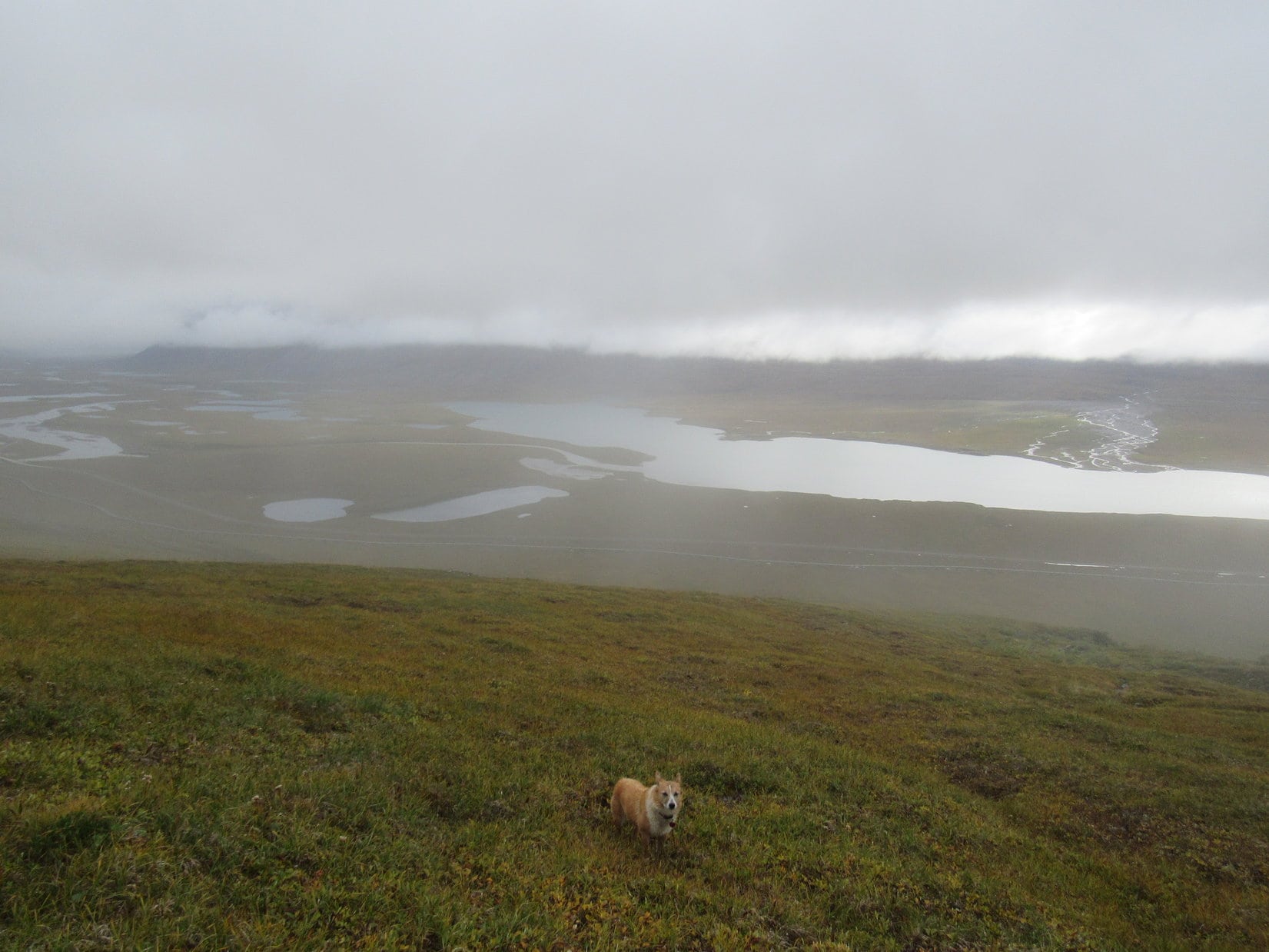
The Stroll to the North Slope Knoll was a marvelous journey! Learned something right away. Where the tundra was yellow and gold, the ground was boggy and wet. Where reddish and pale green plants were dominant, small rocks and drier, firmer footing existed. The tundra had way more yellow and gold on offer than reds and pale greens, but SPHP found ways to link up the reds and greens sufficiently to avoid getting wet feet. Lupe sniffed and played wherever she pleased, unconcerned by such trifles as wet paws.
Lupe stands near the start of a long stretch of reds and pale greens leading toward the nearly imperceptible North Slope Knoll she was heading for. Photo looks NW.
The tundra also harbored large mushrooms, many more than half a foot in diameter. They weren’t super common, but it wasn’t necessary to look long before finding one, either.
The tundra harbored large mushrooms, often half a foot in diameter.
The North Slope Knoll turned out to be more like 0.33 mile from the G6, not 0.25 mile. Even so, the strange, incredible sensation of walking as far N as one ever would was over all too soon.
The knoll wasn’t all that perceptible even standing there right on it. The rise was almost a figment of SPHP’s imagination, amounting to little more than a short ridge only a few feet high. This was it, though. Likely as far N in the world as Lupe and SPHP would ever be.
A patch of green next to a barely medium-sized rock seemed to be as high as anything else. That rock would do. It could be the official endpoint of the Stroll to the North Slope Knoll. Naturally, congratulations were in order. SPHP shook Lupe’s paw, praising her for reaching the North Slope of Alaska beyond the Brooks Range.
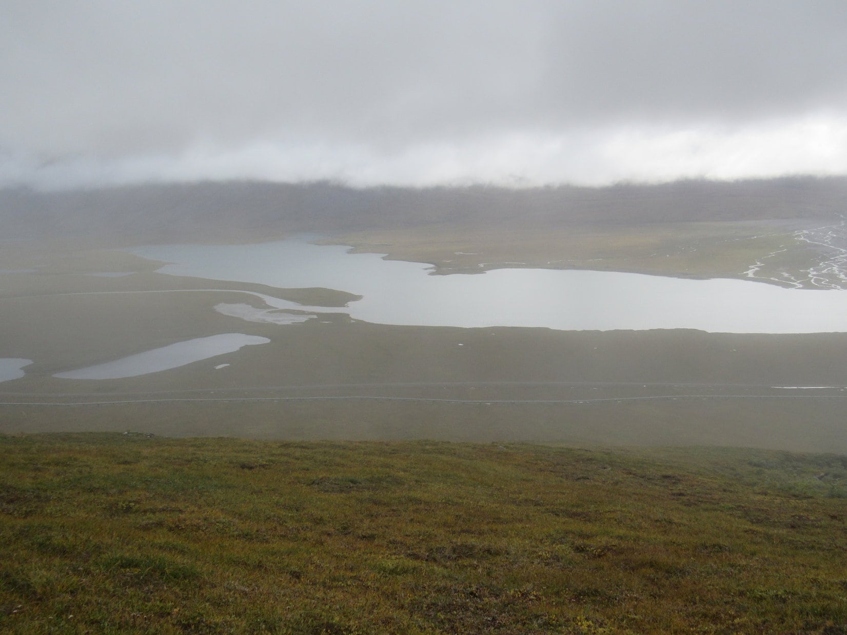
The views of the North Slope were beautiful. Rolling tundra, small lakes, big hills. In the distance, small mountains. All empty and pristine, as if humanity’s teeming billions didn’t exist. The world looking as it always had for eons, yet for how much longer? A blink of an eye? A depressing thought, but only SPHP’s. To the American Dingo the world looked as it should, completely normal.
Completely normal? Oh, I don’t know about that, SPHP! The North Slope is pretty and vast and empty enough, but is in desperate need of more squirrels! Photo looks N.On the patch of green at the end of the Stroll to the North Slope Knoll. Photo looks NW.Looper at the North Slope Knoll, as far N as she had ever been. She’s broken her old 2016 record by 71 miles here.Looking back from the North Slope Knoll toward the Dalton Highway and Alaska oil pipeline. The G6 is a mere dark spec on the R. Photo looks SSE.
Lupe and SPHP returned to the G6 energized and enthusiastic! (10:58 AM, 40°F) The Stroll to the North Slope Knoll, though short, had been an amazing, fun experience to remember always. Now it was time for Lupe to make an attempt on Lake Benchmark Mountain, the mountain at the far N end of the Brooks Range she had come so far to climb.
Feeling sad, SPHP drove S on the Dalton Highway. If the sky would clear up for a little while this afternoon, Lupe should have a tremendous view of Alaska’s North Slope from Lake Benchmark Mountain. However, she would never again actually be out on the North Slope, and as far N as she had just been at the little knoll.
Lupe on the Dalton Highway on her way S again. She hasn’t gotten far yet. Galbraith Lake is in view. Photo looks S.The Galbraith Lake airport is beyond Lake 2660 on the L. Photo looks SW from the Dalton Highway.
After crossing the bridge over the Atigun River, SPHP parked the G6 at a large parking lot on the W side of the Dalton Highway. Lupe would start for Lake Benchmark Mountain(5,000 ft.) from here. (11:32 AM, 42°F)
Lupe at the parking lot on the W side of the Dalton Highway just S of the Atigun River. SPHP mistakenly believed Lake Benchmark Mountain was the high distant ridge seen straight up from Lupe. Photo looks N.
Lupe started out by crossing the Dalton Highway bridge back over to the N bank of the Atigun River. She continued N on the highway to a side road that went E to the Alaska oil pipeline service road.
Following the oil pipeline service road is always fun and easy! Lupe had a good time racing around on the tundra nearby, while SPHP stuck to the road going N.
Looper on the Dalton Highway bridge over the Atigun River. Peak 5308 is at Center. Photo looks E.Loopster having a blast on the Alaska oil pipeline service road. Soon she would have to leave it to climb the big ridge on the R. Photo looks N.A crow wonders what a Carolina Dog is doing way up here at the N end of the Brooks Range?The Dalton Highway and Alaska oil pipeline head off to the NW. Alaska’s North Slope is only a few miles away. Photo looks N.
A beautiful, high rounded ridge was NE of the Alaska oil pipeline. That ridge was the way to Lake Benchmark Mountain. After 0.5 mile, Lupe and SPHP left the pipeline service road to start climbing. The lower and upper slopes of the ridge were spongy, boggy, and full of tussocks. Only the steepest part of the ridge was relatively dry. Lupe followed a long ravine containing a small stream as she climbed NE.
Loop enjoys fresh bog water shortly after leaving the oil pipeline service road.At the base of the beautiful rounded ridge Lupe was about to climb. The ridge proved to be surprisingly wet territory except where it was steepest. Photo looks ENE.
SPHP marched steadily upward while Lupe ran happily exploring the wide open spaces. Once in a while, the Carolina Dog roamed so far away she was completely out of sight. SPHP had to call her back then lest she decide the life of the wild Dingo was for her. Meanwhile, the views of Galbraith Lake and the Atigun River back to the S and W were becoming increasingly impressive.
After a good climb, Lupe has a terrific view back toward the Atigun River valley. Photo looks S.
Lupe went on beyond the end of the stream. The slope of the ridge was gradually diminishing, but Lupe never came to any definite ridgeline. She was wandering up an enormous slope that kept going higher. The whole place was spongy, boggy tundra, full of tussocks.
A big hill was ahead at the far N end of the ridge. SPHP believed this hill was either part of Lake Benchmark Mountain or would lead to it, but wanted to get a view of the territory E of here in order to confirm that opinion. Although Loop went NE for what seemed like a long way, she never did get to a viewpoint. She just kept going higher and higher.
Ahead was a big hill that SPHP believed was either part of Lake Benchmark Mountain or would lead to it. Efforts to get a view of what was E (R) of here failed. The slope just kept going gradually higher and higher that way. Photo looks N.
Before Lupe got high enough to see anything to the E, clouds and fog blew in out of the W. Hopefully they were temporary phenomena. Looper was looking forward to a glorious panoramic view of the North Slope from the top of Lake Benchmark Mountain.
The fog made it certain Lupe wasn’t going to be able to get a view to the E now. She gave up on that idea, and headed straight for the big hill at the end of the ridge.
With fog starting to roll in, SPHP decided maybe Lupe ought to head straight for the big hill. Photo looks NNW.
Fog completely took over. The hill Lupe was heading for disappeared. So did everything else except immediately surrounding terrain. SPHP used occasional large isolated boulders to help keep Loop aimed in the right direction, sighting along them to the next boulder the American Dingo should head for.
Lupe reached the base of the hill, and began to climb more steeply. She went up a series of rocky ramps and benches. Although Lupe still came to patches of vegetation, overall this was much firmer ground free of the bogs and tussocks present lower down on the big ridge. SPHP had a far easier time here, despite the greater angle of ascent.
Loop keeps going up the rocky ramps despite the fog.Fog is getting thicker, SPHP! … I see that Loop. It’s about the only thing I see besides you.
Partway up the hill, Lupe came to a level area where there was more vegetation again. By now a cold rain had started in. Suddenly Loop wasn’t having as much fun as before.
SPHP started becoming concerned about what little could be seen. A substantial cliff dropped into a gray abyss along the NE side of this level area. According to the topo map, it shouldn’t have been there. It most certainly was, though. To the NW, the hill went still higher, but nothing at all could be seen to the E except more fog.
Partway up, Lupe stumbles onto a flat spot with more vegetation again. To the NW, the hill rose still higher, but to the E there was a cliff on the NE side of the hill. According to the topo map, that cliff shouldn’t have been there. Photo looks NW.
That cliff was bothersome. It couldn’t be reconciled with the topo map at all, if Lupe was actually on her way up Lake Benchmark Mountain. SPHP was beginning to suspect maybe Lupe was too far W. Who could tell, though, in this rain and fog?
May as well check out the rest of the hill to the NW. Lupe climbed two higher ridges. She wasn’t at the top of anything significant yet. All she could see was another two even higher ridges farther up the slope. The highest ridge was shaped vaguely like what Lake Benchmark Mountain’s summit ought to look like, but hardly any detail could be seen. How much higher was it? SPHP guessed maybe 500 or 600 vertical feet.
The rain, which had slackened up for a little bit, now turned to snow. The snow wasn’t sticking yet, but added to SPHP’s growing sense of uneasiness. Lupe wasn’t uneasy. She was just getting plain old wet, cold and miserable.
Wandering around up on mountains at the N end of Alaska’s Brooks Range in rain and snow with almost no visibility? Maybe this was getting just a little too stupid. SPHP asked Loopster if she wanted to go back to the G6? The American Dingo gave her most ecstatic, enthusiastic response possible.
A bitter defeat, but there seemed to be no sensible alternative. Dang weather, anyway! How long had it been since Lupe had seen a truly sunny day now? Seemed like forever ago. Every day it was dodging clouds and rain. Lupe and SPHP headed WSW, starting back down.
Loop on a huge rock shortly after starting down. Photo looks NW.I hate to give up, but we can’t see a thing. It’s raining or snowing all the time so I’m cold and soaking wet, and SPHP doesn’t seem to have a clue where we are. Under the circumstances a meal and a warm blankie back at the G6 is sounding mighty good to me! I mean, what would you do?
Lupe hadn’t lost much elevation yet when suddenly a break appeared in the clouds. Galbraith Lake was in sight! Out came the topo map for comparison with the lake to try to get reoriented again. SPHP quickly became convinced Lupe wasn’t on Lake Benchmark Mountain at all. She was somewhere on the upper S slopes of Peak 4700! She was indeed a mile too far W, as SPHP had begun to suspect a while back.
While SPHP was still pondering the implications of this discovery, the sky cleared off to the NW, too. Lupe could clearly see several high points over that way. Another review of the topo map convinced SPHP that Peak 4700 was really the next peak over to the WNW. In that case, Lupe actually was somewhere on Lake Benchmark Mountain.
The views disappeared again as another batch of clouds plunged the hill Lupe was on back into fog. Still, the brief break in the weather had been encouraging. Maybe conditions were beginning to improve? The hasty decision to return to the G6 was rescinded. Lupe and SPHP set off back up whatever hill or mountain this was.
The climb to the top wasn’t nearly as far as the fog had made it seem. After gaining only 200 to 250 feet of elevation, Lupe was approaching a line of boulders on what appeared to be part of a summit ridge. Looper scrambled up a gap between boulders. A survey pin could be seen only 20 feet away to the E! Hopes soared that maybe Lupe had just stumbled upon Lake Benchmark?
No, there wasn’t a benchmark, just a survey pin. Looper and SPHP searched the tops of the highest boulders along the ridgeline. Nothing. The top of the survey pin was clearly stamped “Coronary Apsoo No. 4”. Clear alright. Clear as mud. Meant absolutely nothing to SPHP. It may as well have been Chinese.
“Coronary Apsoo No. 4”. Big help that.Lupe relaxes near Coronary Apsoo No. 4 (Center), while SPHP draws a blank as to what it meant. The obvious next step was to go to the higher point seen through the fog. Photo looks NE?Oh, of course I know what Coronary Apsoo No. 4 means! Who doesn’t? I’m just seeing if you know, SPHP. Come on, figure it out!
Apparently Coronary Apsoo No. 4 meant “Go to the obviously higher point so close by that you can even see it through the fog, dummy!” Nothing else really sprang to mind. So after drawing a blank by this first survey pin, Lupe and SPHP headed NE on a short easy ridge walk to a noticeably higher point nearby.
The next high point appeared to be the top of the mountain. The summit area wasn’t huge but was plenty big enough to wander around a bit. No survey benchmark could be found up here, either, only another survey pin stamped with an equally cryptic message.
Lupe must be at the top of either Lake Benchmark Mountain or Peak 4700, but which was it? Lupe stood in the rain while SPHP tried to work it out. A slightly lower narrow rock ridge was in view to the E or SE, but didn’t look nearly large enough or long enough to be Lake Benchmark Mountain’s E ridge. A short distance to the N was a subpeak nearly as high as where Lupe was. That didn’t look right either.
In mist and fog Lupe stands at the top of the mountain. The question was, which mountain was it? The narrow, slightly lower rock ridge seen in the fog beyond Loop didn’t appear nearly large or long enough to be Lake Benchmark Mountain’s E ridge. Photo looks ESE?Not too far to the N was a subpeak almost as high as where Lupe was. That didn’t match up with what the topo map showed for Lake Benchmark Mountain, either. Photo looks N.
On a sunny day, there wouldn’t have been any question where Lupe was. It appeared more and more that she might well be at the top of Peak 4700. However, if this was actually Lake Benchmark Mountain, there ought to be a “Lake” survey benchmark back somewhere along the line of boulders near the first Coronary Apsoo No. 4 survey pin. Looper returned to the pin and once more searched diligently along the line of boulders. Nothing.
One last thing to try. Loop and SPHP returned to the mountain’s summit, then continued over to the N subpeak. Nope. Not a thing here either. So this was almost certainly Peak 4700. Due to the fog, Lupe had climbed the wrong mountain!
The heavy mist turned to snow. Sheesh! Better head down.
Lupe lost 200 feet of elevation. The snow quit again. Already it wasn’t as foggy as higher up. Maybe Looper should angle SE hoping to catch a glimpse of Lake Benchmark Mountain? Seemed like a reasonable course of action.
On the way down Peak 4700, the mountain Lupe had no intention of climbing, but did. Photo looks N.
Going down the ramps and benches, Lupe started to discern the faint foggy outline of some big hill off to the E. Lake Benchmark Mountain? Seemed like it had to be. The Carolina Dog reached the fairly level area she had been to on the way up Peak 4700. She headed E near the cliff to the NE. Yes! No mistake. Lake Benchmark Mountain was in view!
The big hill at Center is the W end of Lake Benchmark Mountain. Photo looks E.
Wow, there was still a pretty big elevation drop between here and there! At least it wasn’t as foggy out as earlier. The really good news was that what could be seen of Lake Benchmark Mountain looked climbable. Just a really big, fairly steep hill, but no worse than that.
Now or never! By the time Looper had worked her way down Peak 4700’s long SE ridge to a wide boggy flats leading to Lake Benchmark Mountain, she had lost 600 feet of elevation. She would have to regain it all plus another 200 feet to reach Lake Benchmark’s summit.
The climb was definitely steeper than Peak 4700 had been. The lower slope was easy. As things became steeper, lanes of vegetation leading up scree covered slopes helped. Lupe eventually reached areas of nothing but scree. Fortunately she had already regained a ton of elevation by then.
Starting up the W end of Lake Benchmark Mountain. Easy down here, just a big hill! Photo looks NE.Higher up on the scree slopes looking back at Peak 4700, which Lupe had just climbed in the fog by mistake. Photo looks W.
By the time the slope of the mountain moderated, Lupe was pretty high. She was back into fog, and it was snowing. The snow was starting to stick. A series of wide, relatively level areas covered with vegetation ran roughly E/W in long strips. These strips of land were separated by minor slopes or ridges, which presented walls of rock or lines of boulders in some areas, although it was always possible to go around them.
Lupe followed each of these vegetated bands some distance E before turning N and climbing up to the next one. The climbs were short and never difficult.
Loopster fairly high up on the W end of Lake Benchmark Mountain now. She’s near the start of the E/W bands of vegetation separated by ridges where there was more rock. The bands to the N were higher than those to the S. Photo looks NNE.Loop on another strip of vegetation with a typical rock wall providing separation from the next higher band beyond it. Photo looks NE.
After crossing several of these vegetated bands and climbing to higher ones, Lupe was faced with a more formidable, longer wall of rock. Was that the summit ridge? It certainly seemed possible. The Carolina Dog traveled E below the wall of rock until she reached a place where it was possible to scramble up. Nope. Not the summit. Off to the NE was an even higher rounded hill.
Lupe could get up on that rounded hill easily enough! She went right to it and was soon on top. Poking around a collection of rocks at the high point revealed nothing. Then suddenly, there it was! Lower down, a little farther E, some sort of survey marker was sticking up from a loosely assembled modest cairn. Was it true? Was that it?
Oh, yeah! This was it! Lupe had found the really, truly, genuine Lake Benchmark. Celebration time!
The really, truly, genuine Lake Benchmark.A wet Dingo stands next to the authentic Lake Benchmark.All I can say is, thank heavens it’s not stamped Coronary Apsoo No. 5! Loop next to the Lake Benchmark (lower R). Photo looks W.
Although finding the Lake Benchmark was cause for joy and undeniable proof that Lupe was actually on the right mountain this time around, the survey benchmark was not quite at the top of the mountain. The topo map showed an elevation of 4,928 feet here. However, it also showed a small area within a 5,000 foot contour not too far away to the E.
If Lupe wanted to claim a peakbagging success, she needed to go find that higher ground where the true summit of Lake Benchmark Mountain had to be. After going through all this miserable weather and climbing the wrong mountain, the Most High Exalted Dingo of the Arctic Sisterhood most certainly did want to claim a peakbagging success here, too! Whether she could see anything or not!
So after congratulations and a brief celebration at the actual Lake survey benchmark, Lupe and SPHP headed E along a relatively narrow level ridge looking for the summit.
Joy turned to dismay. Loop hadn’t gone far, when up ahead, ghostly rock formations appeared in the fog. They looked potentially unclimbable for the American Dingo.
Lupe hadn’t gone far from the Lake survey benchmark when she saw a potentially unclimbable rock formation ahead. No!!! Photo looks ENE.
SPHP’s fears were unjustified. Lupe reached the summit area to find massive boulders and a wall of rock, but open lanes existed providing her an easy scramble to the top. And just like that, Lupe was there, perched at the undeniable summit of Lake Benchmark Mountain(5,000 ft.)! Oh, happy day!
Ta da! Lupe stands at the true summit of Lake Benchmark Mountain at the N end of the Brooks Range in N Alaska. Photo looks WNW.Could maybe have picked a better day for this, SPHP! The mighty, spectacular, sweeping view of the North Slope from here isn’t all it’s been cracked up to be!
The summit was a knob of rock perhaps 20 feet long and 5 feet wide. The S side of this knob was a solid rock wall 6 to 8 feet high next to a level patch of tundra. To the N, the knob sloped steeply away toward a chasm of undetermined depth. Of course, standing up there in light rain and fog, Lupe could see none of the glorious view of the North Slope that she had come so far to see, and would have had on a clear day.
Lupe astride the true summit. Most of the summit knob is seen here. Photo looks NW.
Lake Benchmark Mountain was a grand peakbagging success for the Carolina Dog, but a complete scenic fail. That really was a shame, since Lake Benchmark Mountain was likely destined to be the northernmost peak Loopster would ever climb in her whole life, and the views ought to have been spectacular.
Lupe thinking deeply profound Dingo thoughts about the significance of being way up here in N Alaska at the top of this fabulous mountain in the Brooks Range.Hey, SPHP! I was just thinking, since the views are a total bust, did you bring anything to eat?
At least Loop had gotten to see the North Slope this morning on her Stroll to the North Slope Knoll. Better yet, yesterday evening she had arrived at a fantastic, magical moment to see it for the first time ever when there was rain and sunshine and rainbows and a sea of gold out there. Still would have been fantastic to see the North Slope from up here, but that’s the way it goes.
With no views, and no real hope of seeing them anytime today, there wasn’t much point in hanging around up here in the chilly rain for long. Shaking her cold, wet paw and trying to make her achievement sound as grand as possible, SPHP congratulated Lupe on her Dingo persistence and ultimate success in getting to the top of Lake Benchmark Mountain. Lupe loved the attention, but looked rather miserable.
Loop ready to begin the descent.
Lupe was ready to go. A mere 10 minutes after arriving, Lupe and SPHP began the descent. By the ghostly rocks, Loop paused for a final look back.
Looking back at the ghostly summit. Photo looks ENE.Leaving Lake Benchmark Mountain. Photo looks ENE.
The rocky apparitions vanished from sight almost as soon as Lupe left them. She would never see them again.
Going back down the bands again was pretty easy. SPHP had built a cairn on the way up to help mark the route, but Loop didn’t come across it. It started snowing again for a little while, but turned to rain lower down on the steeper scree slopes.
For 10 minutes, the clouds lifted a bit. Lupe could see the Atigun River 2,000 feet lower at the bottom of a deep valley to the S. Off to the SW, where it was still foggy, the fog had a strange brownish tinge. It looked like smoke. Smoke? How could that possibly be? SPHP puzzled for a moment or two, before the fog thinned.
That wasn’t smoke! That was the golden boggy tundra way down there on the big ridge Lupe had come up at the start. Loop was going the right way. She was heading straight for it.
Lupe reaches the low ground W of Lake Benchmark Mountain. Peak 4700 is in fog ahead. Lupe wasn’t going there again. She went SSW (L) instead. Photo looks WNW.
The fog returned. The big boggy ridge seemed endless. It rained the whole time. For a while, Lupe trudged along sopping wet and depressed at SPHP’s heels. Finally, something caught her interest. The Carolina Dog was off like a shot. Despite the rain, she ran great distances. Loop was having fun again! She ran and sniffed the rest of the way.
At last, Lupe was far enough down to get below the clouds. Galbraith Lake came back into view. The Dalton Highway and Alaska oil pipeline were down there, too.
Near the end of a long wet march along the huge boggy ridge, Galbraith Lake came into view again. Photo looks SW.Getting there! The S end of Galbraith Lake is in view. Lupe still needed to get back down to the Atigun River (far L), but that wouldn’t take too long. Photo looks SSW.N end of Galbraith Lake. Photo looks W.
Wouldn’t be too long now before Looper was warm and dry, snoozing snugly beneath her blankie with a full belly. Lupe never would see that glorious view of the North Slope from Lake Benchmark Mountain, but she had been up there. She had stood at the very top of a mountain at the N end of the Brooks Range in northern Alaska. Not many Dingoes can say that. (7:29 PM)
On Lake Benchmark Mountain, N end of the Brooks Range in Northern Alaska 8-19-17