Days 10 – 13 of Lupe’s 2017 Dingo Vacation to the Wind River Range, Wyoming & Select Peaks in Montana
Day 10, 7-17-17 For the first time on this Dingo Vacation, the night sky was clear. Lupe wanted out. She sniffed around invisibly in darkness. Overhead, the Milky Way gleamed in the heavens amidst diamond bright constellations. The Carolina Dog was still tired, though. She quickly returned to resume her snooze.
Morning arrived. Time to leave the magnificent Wind River range. Lupe and SPHP went down to lower Green River Lake. The American Dingo gazed once more upon Squaretop Mountain (11,695 ft.), the massive NW sentinel of the Winds, looming silently beyond the clear, still lake.

Lupe’s attempt to climb Squaretop had ended in failure, though she did look down on its summit from New Benchmark (11,850 ft.), the high point of her 3 day journey. Though ultimately unsuccessful, the effort to reach Squaretop from Porcupine Pass had been a beautiful and challenging adventure.

Today would be the first of several travel and rest days. After stopping in Pinedale for supplies, Lupe and SPHP headed NW on Hwy 191 past Bondurant and Hoback Junction. The S approach to Jackson was teeming with tourists and activity. The mob scene at the heart of it all was avoided by turning W on Hwy 22, which took Lupe over Teton Pass (8,429 ft.).
Lupe crossed the border into Idaho for the first time in nearly 5 years. W of the Teton Range, Lupe and SPHP were in unfamiliar territory. Dark clouds hung over the Tetons. N of Driggs, Lupe experienced 20 miles of cloudburst, as SPHP drove N on Hwy 33. Beyond the thunderstorm, it was sunny again.

SPHP drove all day. Lupe saw beautiful scenery she’d never seen before. She barked at cows and horses. She lapped up chocolate milk. After several hours in Idaho, she left it again crossing into Montana on Hwy 87. By day’s end, Lupe was a mile S of Silver Star at a pullout along Hwy 41 overlooking the Jefferson River.


Day 11, 7-18-17 The next morning, Lupe and SPHP headed N. Approaching Deer Lodge on I-90, Mount Powell (10,168 ft.) came into view a dozen miles to the W. SPHP left I-90 at Exit 195 and drove all the way to the trailhead to see if the G6 could get there. The roads weren’t bad, although the final stretch on USFS Road No. 670 was so narrow it was a good thing no vehicles were coming the other way. Lupe spent most of the afternoon at the trailhead, happily relaxing in the shade watching squirrels and chipmunks.


Mount Powell was Lupe’s next peakbagging objective, but no attempt on the mountain was going to be made today. Late in the afternoon, Lupe and SPHP went down to Deer Lodge where Lupe enjoyed a McDonald’s ice cream cone. Lupe’s evening was spent watching boats, sea gulls, geese, and little fish jumping at Georgetown Lake W of Anaconda.


Day 12, 7-19-17 Three miles E of Georgetown Lake, SPHP noticed a sign for Storm Lake on the S side of Hwy 1. Lupe had time, why not check it out? The G6 made it nearly 8 of the 9 miles to Storm Lake on USFS Road No. 675. Lupe and SPHP continued on paw and foot. Clearings in the forest near the road were full of colorful wildflowers.

Several groups of people were fishing at Storm Lake when Lupe arrived. Across the lake Looper could see Little Rainbow Mountain (9,989 ft.), which didn’t look like it would be too hard a climb. A trail led across a dam at the N end of the lake. At the W end of the dam, Storm Lake Creek exited the lake. Lupe and SPHP crossed the creek, and followed the trail S along the W side of Storm Lake.

After a long week in the Wind River range, SPHP wasn’t too ambitious. Instead of climbing Little Rainbow Mountain with the American Dingo, SPHP opted for a swim in the lake. Lupe was content to go wading, too.

The trail continued SE beyond the S end of Storm Lake. Several hikers came along about this time. One of them showed SPHP a map indicating that the trail would wind its way S for a mile or so to Storm Lake Pass. Mount Tiny (9,848 ft.) was supposed to be an easy climb from there. Still feeling lazy, Lupe and SPHP skipped Mount Tiny. Lupe left the trail to circumnavigate Storm Lake instead.
After returning to the G6, Lupe and SPHP spent part of the afternoon at a park along Warm Springs Creek in Anaconda. By evening, Loop was back at the Mount Powell trailhead.
Day 13, 7-20-17 After a day of travel and two days spent lazing around, the Carolina Dog woke up at 5:20 AM. SPHP joined her outside the G6. Today was the big day! Lupe was going to climb Mount Powell! SPHP had everything ready in short order, but then did nothing. Lupe was puzzled. What was the holdup? She was anxious to get going.
Suddenly, those big soft Dingo ears heard a noise. Something was coming! A yet unseen vehicle was approaching the trailhead. A minute later, a silver Jeep Wrangler Rubicon appeared. Lupe ran over barking to greet it. Much to her surprise, out of the Rubicon stepped someone she knew – mountaineer Jobe Wymore!
Lupe hadn’t seen Jobe since she’d served as his advance scout at South Dakota’s second highest mountain, Odakota Mountain (7,200 ft.), back home in the Black Hills. That had been more than 15 months ago. On 4-2-16, Lupe had actually accompanied Jobe to Odakota, and then gone on to the Wildcat Hills of Nebraska with him that very same day. In Nebraska, she’d climbed Wildcat Mountain (5,025 ft.) before succumbing to the prickly terrors of cacti. Jobe had helped carry the tenderpaw Dingo out of danger back to the Bluffman’s house.
Now Jobe was coming with Lupe to Mount Powell! She could hardly believe it! She barked, leapt, and danced wildly around Jobe. Of course, Jobe’s arrival was no mere coincidence – it had been prearranged. And actually, Jobe wasn’t really coming along with Lupe and SPHP. It was the other way around, Lupe and SPHP were tagging along on a mountain that Jobe needed to climb.
Mount Powell (10,168 ft.), the high point of Powell County in Montana, is on two massive peakbagging lists Jobe has been working on for years. One list with 245 peaks (the short list!) contains all of the US county high points in all 48 contiguous states with at least 2,000 feet of prominence. The other, longer list includes all 414 county high points of the western contiguous states (all the mountain states W of the prairie states).
After greetings were exchanged, Jobe, Lupe and SPHP set out on USFS Road No. 670, which was extremely rough W of the trailhead. The road led steadily up the forested valley of the Dempsey Creek drainage.
SPHP’s prior research of possible routes up Mount Powell had shown that most climbers stay with the road at least as far as the mountain’s S ridge beyond Bohn Lake. Some go all the way to a SW ridge in the vicinity of the Elliot Lakes. These ridges were described in various reports as brushy, steep, cliffy, and containing boulder or scree fields.
However, climber Eric Higginbotham had explored a different route which sounded a lot easier. The Higginbotham route left the road much sooner. It passed through a huge alpine meadow (Marble Park on the map) early on, climbed in forest to High Point 8708, continued NW over a saddle, and eventually broke out of the forest on a broad ridge a mile SSE of the summit.
Higginbotham’s 7-19-15 Mount Powell trip report included a GPS track, an excellent description of how to find the trailhead, and a rather amusing account of his experience as well. SPHP favored trying Higginbotham’s route. Jobe must have, too. Being technologically competent, he had already loaded Higginbotham’s GPS route into his smart phone.
The first thing to watch for was an open grassy slope on the NW side of the road about 0.67 mile from the trailhead. The steep hillside soon came into view as Higginbotham had described it. Jobe and Lupe led the way up.

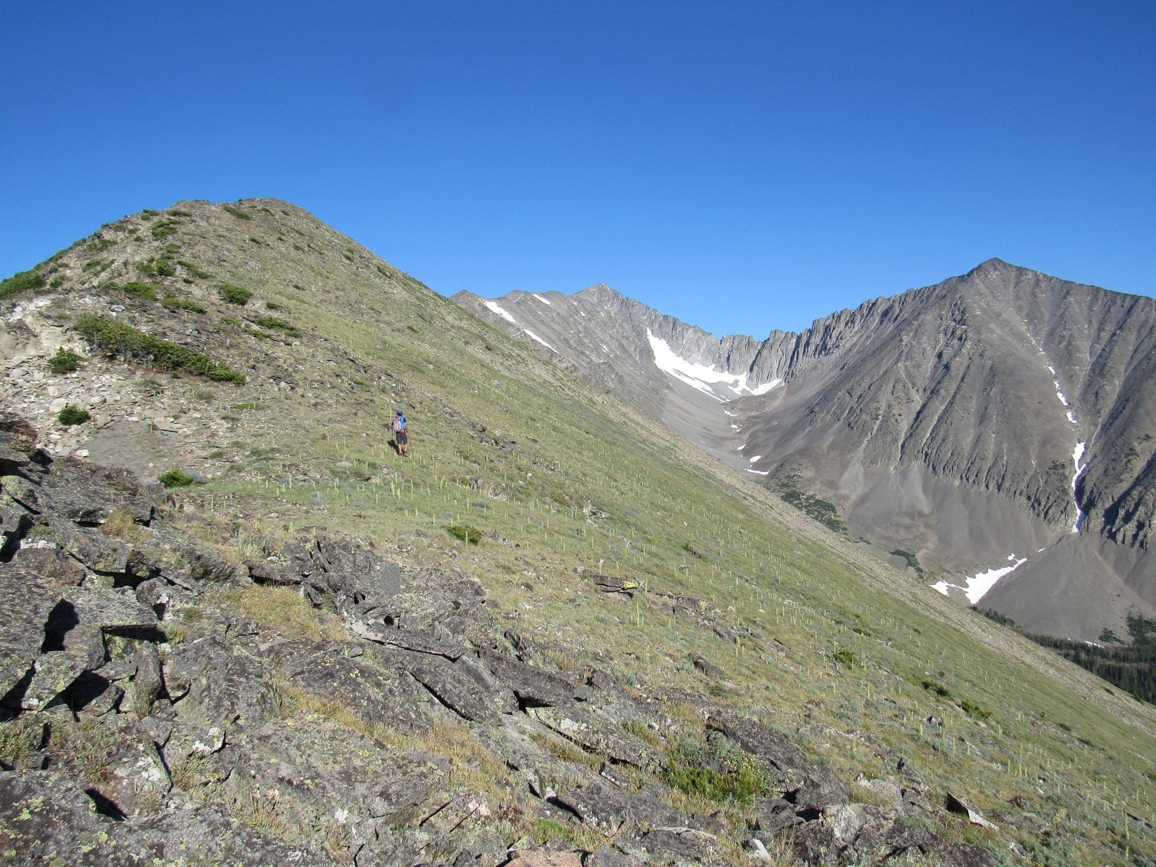
At the top of the steep hillside, Lupe re-entered the forest. The ground leveled out to some degree as she continued up, heading W near the edge of the steep stuff. Before too long, the terrain started pushing her N. Loop quickly came upon the S end of Marble Park, the giant alpine meadow Higginbotham had mentioned.


Marble Park was completely free of obstacles. Jobe, Lupe and SPHP made rapid progress up the steady, moderately inclined slope. Lupe stayed in the giant meadow as long as possible. She didn’t re-enter the forest again until reaching Marble Park’s upper N end. This allowed the American Dingo to completely avoid a shallow drainage to the W.
Once back in the forest, the next landmark along the way was High Point 8708, about 0.75 mile to the NW. The forest was mostly open, the only real obstacle being scattered deadfall timber. The climb initially steepened somewhat, but quickly became more gradual again. Now and then, Jobe checked Lupe’s position versus Eric Higginbotham’s GPS track on his phone, but very little course correction was ever required.
When Lupe, Jobe and SPHP reached High Point 8708, the top of Mount Powell was in view 2 miles to the NW.


At High Point 8708, Lupe had already climbed 2,450 feet of the over 3,900 feet of elevation gain required to get to the summit of Mount Powell from the trailhead. SPHP was amazed at how easy it had all been, and how quickly the time had gone by. Credit for the easy route went to Eric. Credit for making the time go by fast went to Jobe.
Lupe and SPHP really didn’t know Jobe well at all. The only other time Lupe had been with Jobe was on that one day over 15 months ago. Jobe had been friendly, considerate, and very kind. He’d come to Lupe’s rescue carrying her over cactus infested badlands in Nebraska. Jobe had also been a great conversationalist, expounding upon a variety of topics of interest to SPHP.
Shortly after leaving the trailhead this morning, Jobe had launched into a discussion of one of his favorite subjects – Jerry Garcia and the Grateful Dead. Of course, SPHP was familiar with some of their top 40 hits, but that was about the extent of it. Jobe, however, was an expert. He didn’t consider the Dead’s top 40 hits even remotely among their best work.
Virtually the entire time it took to reach High Point 8708, Jobe had expounded upon the Grateful Dead. A truly dedicated (fanatical?) fan, he listens to them almost exclusively. Jobe knew not only all of the Dead’s songs, but how the songs had evolved and been perfected over time, at exactly which live concerts Jerry Garcia had performed the best renditions, all of the lyrics and their meanings, etc., etc.
SPHP couldn’t begin to absorb it all, but did gather that of the many Grateful Dead songs Jobe liked, he considered Morning Dew and Terrapin Station among their finest work. Even though the subject matter was almost entirely unfamiliar to SPHP, Jobe’s enthusiastic and lively conversation had been so entertaining, it hardly seemed possible Lupe was already so close to Mount Powell.
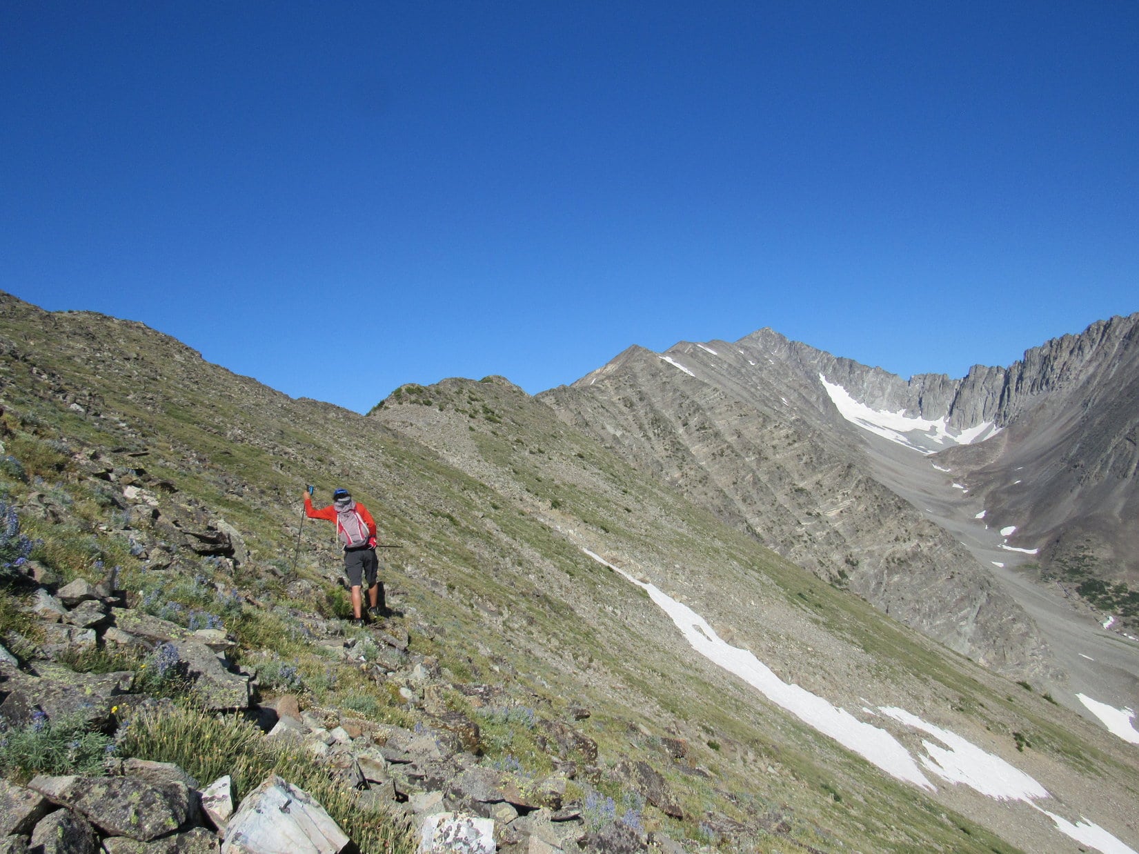
Close she was, though. Only a 0.75 mile long forested area, a significant portion of which was a relatively level saddle, now stood between Loop and the broad, bare S ridge leading to the final steep climb to the top of the mountain. As Lupe left High Point 8708, and proceeded NW across the saddle, Jobe continued his time and distance warping commentary. In no time at all, almost as if she had been teleported, the Carolina Dog broke out out of the forest and stood on the bare S ridge.
The lower part of the S ridge was a gentle incline, generously strewn with medium-sized flattish rocks, which were interspersed with small green plants and a few wildflowers. Mount Powell was directly ahead.

The final ascent wasn’t any steeper than the grassy hillside Lupe had gone up right after leaving the road early on. This slope was much rockier, but still just a walk up a hill. Vegetation was present most of the way. Lupe faced only a few short sections of nothing but scree.

Loopster arrived at the summit of Mount Powell (10,168 ft.) at 9:00 AM. Between Eric Higginbotham’s excellent route, and Jobe’s scintillating conversation (which by now had switched from the Grateful Dead to how life would be affected by coming technological changes), the whole trek up had taken only 3 hours. To SPHP, it seemed like the easiest 3,900+ feet of off-trail elevation gain ever.

The summit area was roomy, flat and strewn with rocks. Lots of rocks had been piled up to make a big circular Dingo fortress with a cairn in the middle of it. A survey benchmark was easily found. Not a tree or a bush grew anywhere, so the summit provided commanding 360° views. Unfortunately, smoke from forest fires farther W made the air rather hazy. Smoke could be seen rising from several points.


Lupe, Jobe & SPHP remained at the top of Mount Powell for a whole hour. Jobe pointed out several peaks in the distance he had been to, or at least recognized. As a treat, he shared chocolate brittle with Lupe and SPHP, who were both quite taken with it. An hour was plenty of time to gaze at the grand views in all directions. As a W breeze grew stronger, smoke began billowing up more noticeably from a fire to the SW.


Other than the haze, conditions on Mount Powell were near perfect with a light W breeze and temperatures in the low 70’s °F. Nevertheless, the time to depart drew near. Lupe took a final look around, while Jobe used his phone to enter data on this successful ascent.


Eric Higginbotham’s route up had worked great! There was no reason to stray from it on the way back to the trailhead. Jobe helped the time go by with stories of the exploits of other mountaineers he knew, and adventures he’d had with some of them. He discussed some of the major peakbagging goals he has been working on for many years, how he was within a few years of completing them, and what he might want to do when they were finished.


By the time Lupe was back at the trailhead (12:40 PM), she knew about an odd medical condition affecting Jobe’s hair, and the sad passing away of his favorite cat, known simply as “H”, in January. Only partly in jest, Jobe had pronounced himself a 3 dimensional person due to his 3 main interests in life – peakbagging, the Grateful Dead, and craft beers.
Climbing Mount Powell with Jobe had been super fun! The best news of all was that Loop’s time with Jobe wasn’t over yet. Tomorrow, Lupe would get to climb another peak with him! The original plan had been to go to Old Baldy South Slope (8,640 ft.). However, that plan had changed. Sacagawea Peak (9,650 ft.), with nearly 4,000 feet of prominence was up next!
Once details for the next rendezvous had been settled upon, Jobe roared off in his Rubicon. A short while later, Lupe and SPHP headed out, too. When Lupe reached I-90, temperatures were in the 90’s °F. So much smoke was in the air now that Mount Powell was barely visible. SPHP stopped to buy a box of ice cream bars in Anaconda. A certain eager Carolina Dog provided dedicated assistance in devouring all 6 on the spot.
An air-conditioned ride E to Bozeman ensued, where SPHP obtained a roasted chicken for dinner. Taking Hwy 86 N out of Bozeman, SPHP eventually found the road to Fairy Lake. The poor G6 took considerable abuse on USFS Road No. 74, making it 3/4 of the way to Fairy Lake before SPHP had mercy and parked at a big pullout. By nightfall, an American Dingo stuffed full of roasted chicken was ready for Dingo dreamland.

Related Links:
To the Wildcat Hills of Nebraska with Mountaineer Jobe Wymore (4-2-16)
Naya Nuki Peak & Sacagawea Peak, Montana with Mountaineer Jobe Wymore (7-21-17)
Crazy Peak, Montana – On the Verge of EPIC with Mountaineer Jobe Wymore (7-22-17)
Morning Dew, The Grateful Dead (7-19-89)
Eric Higginbotham’s trip report on Mount Powell (7-19-15)
48 States County High Points with 2,000+ feet of Prominence
Western Contiguous USA County High Points
Want more Lupe adventures? Choose from Lupe’s 2017 Wind River Range in Wyoming & Select Peaks in Montana Adventure Index, Dingo Vacations Adventure Index or Master Adventure Index. Or subscribe free to new Lupe adventures.