Start: 9:20 AM, 36°F at the Boulder Hill trailhead of Flume Trail No. 50 on USFS Road No. 358 (Boulder Hill Road)
Going to Boulder Hill with Mark and Hillary on Expedition No. 219 had reminded SPHP that while Lupe had been to Boulder Hill half a dozen times, she had never been to nearby Storm Hill. Wasn’t it about time she went?
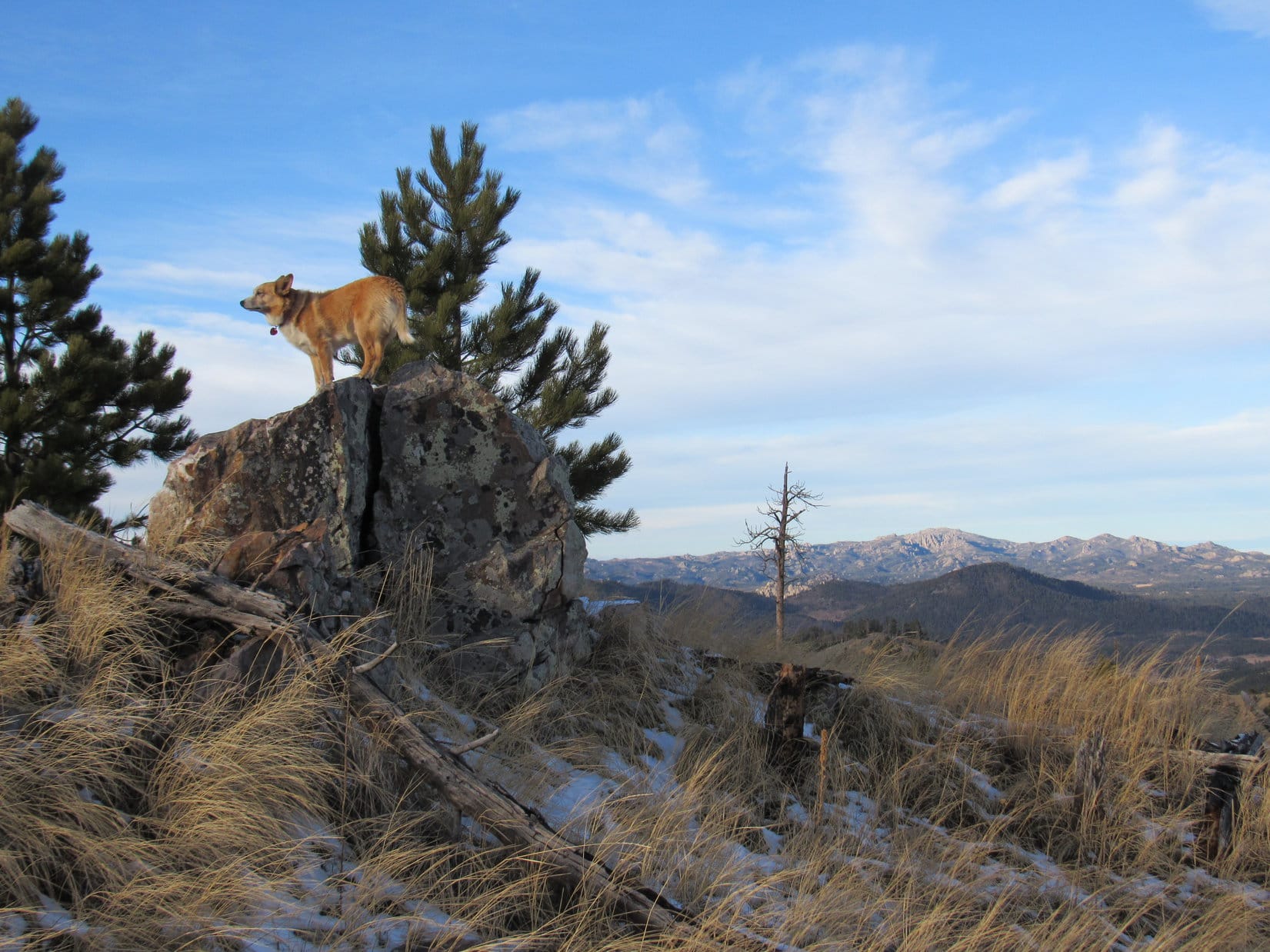
Of course, Lupe was in favor of any idea that would get her out of the house for another Black Hills adventure! Soon she was setting out for Storm Hill(5,192 ft.) from the same Boulder Hill trailhead of Flume Trail No. 50 where she had so recently been with Mark and Hillary.
Lupe sets out for Storm Hill on Flume Trail No. 50. A spur of the trail goes up to Boulder Hill, but that wasn’t Lupe’s destination today. Photo looks SE.
For the first 0.33 mile, Lupe followed Flume Trail No. 50. The trail went SE up to a saddle between Boulder Hill and Storm Hill. With only an inch of snow on the ground, Lupe could have run around exploring easily enough. Instead, she nervously stuck close to SPHP. Distant gunfire could be heard coming from somewhere off to the W. Someone was doing target practice.
On the way up to the saddle between Boulder Hill and Storm Hill. Photo looks SE.
At the saddle, Lupe was between Boulder Hill to the SW, and Storm Hill to the NE. A spur of Flume Trail No. 50 goes all the way up to the top of Boulder Hill, but there isn’t any trail going up Storm Hill. Lupe would have to bushwhack through the forest.
Carolina Dogs love bushwhacking! Despite the distant gunfire, Lupe grew bolder after leaving the Flume Trail. She followed the saddle NE over to Storm Hill. She was going away from the gunfire, which helped her confidence.
On the saddle leading to Storm Hill. Photo looks NE.
Upon reaching the SW slope of Storm Hill, Lupe traveled right on up a rocky spine of the mountain. The climb would have been easier if she had simply avoided the rocks. However, she did get glimpses of Boulder Hill from the rocks she wouldn’t have otherwise had.
Partway up the rocky SW spine of Storm Hill. Photo looks E.Although climbing the rocky SW spine of Storm Hill was harder and slower than avoiding the rocks would have been, Lupe did get some views of nearby Boulder Hill (L) she wouldn’t have otherwise had. Photo looks WSW.The top of Boulder Hill(5,331 ft.) with help from the telephoto lens. Photo looks SW.Boulder Hill (Center) is only 0.5 mile SW of Storm Hill. Lupe had been there half a dozen times, but she’d never been to Storm Hill before. Photo looks SW.
The SW spine of the mountain topped out near the S end of a broader ridge. This broader ridge was also quite rocky, but wasn’t as steep. Lupe gained elevation more slowly as she followed it N. To the E, Loop could see little but forest. However, she did come across places where she had views off to the SW or W.
The SW spine of the mountain led to this broader ridge, which was still quite rocky. Lupe gained elevation more slowly than before as she followed this ridge N. Photo looks N.Another look at Boulder Hill (R) from the broader ridge. The top of Silver Mountain(5,405 ft.) (L) can be seen sticking up between the trees. Photo looks SW.Getting closer to the summit! Loop along the W edge of the broad ridge. Photo looks N.
The summit of Storm Hill was close to the N end of the broad ridge. A fairly large summit area, perhaps 30 or 40 feet in circumference, was the highest part of the mountain. Pine trees obscured the views in some directions. However, Lupe enjoyed a panoramic view to the N and NE from the top of small cliffs.
At the summit of Storm Hill. Photo looks NNE.From the top of small cliffs along the edge of the summit area, Lupe had a panoramic view to the N and NE. Photo looks NE.
By moving around the summit area, Lupe found at least partial views in other directions.
Looking SE.Custer Peak(6,804 ft) (R of Center) with a lot of help from the telephoto lens. Photo looks NW.
Storm Hill has a double summit. Two widely separated areas contained within 5,160 foot contours are on the topo map. Lupe was at the W high point where a site elevation of 5,192 feet was shown. SPHP presumed this was the true summit of Storm Hill. It was hard to get much of a look at the E high point, but there was a spot from which it could be seen.
The E high point was a long, skinny ridge. It was steeper and more rugged-looking territory. The highest parts of the E ridge appeared to be about as high as where Lupe was, but SPHP was pretty certain they weren’t any higher. Satisfied that Lupe had actually reached the true summit of Storm Hill, SPHP didn’t make her spend the extra hour it might have taken to visit the E ridge, too.
This rough skinny ridge E of Storm Hill’s true summit looked almost as high. Much of it was also within a 5,160 foot contour on the topo map. Photo looks E.
Lupe returned to the true summit of Storm Hill, before taking a little break. Meanwhile, SPHP took a few more photos of the views.
After an initial look around, Lupe returns to the true summit of Storm Hill. Photo looks N.Looking NE with help from the telephoto lens. The opening in the far ridgeline seen on the R is the area known as “The Gap” in Rapid City.Baker Park (Center & L) is the grassy open area down below. Photo looks NW.Boulder Hill (L), Mount Warner(5,889 ft.) (R), and Saint Elmo Peak(6,458 ft.) (Center in the distance) from Storm Hill. Photo looks SW.
Lupe spent 20 minutes enjoying the summit of Storm Hill before moving on. The Carolina Dog started back retracing her route S along the broad ridge. She soon left the ridge, however, veering SW to explore easier terrain in the forest below. She reached Flume Trail No. 50 again well N of the saddle where she’d originally left it.
By 11:06 AM (42°F), Loop was back at the G6. Storm Hill had been fun, but had taken her less than 2 hours. Plenty of time left in the day for more adventures! SPHP drove S. Lupe had fun barking at cows, horses, and eventually even some buffalo.At 1:52 PM (41°F), SPHP parked the G6 at the mouth of a grassy valley N of USFS Road No. 336 (Flynn Creek Road) less than a mile S of Northeast Cicero Peak(6,240 ft.). Lupe had been to Northeast Cicero Peak twice before, but her most recent ascent was now more than 2.75 years ago. For fun, she would try a new route up.
Lupe started out climbing NW up a thickly forested ridge on the W side of the grassy valley. She eventually emerged from the trees. An open hilltop was only a short distance away. Loop went to the top for a look around. She was a little S of High Point 5821. Cicero Peak(6,166 ft.) was in view not quite a mile to the SW.
Lupe reaches the hilltop S of HP 5821. Cicero Peak (Center) is in view. Photo looks SW.On her journey up NE Cicero Peak, Lupe would head for the high grassy area seen on the L before turning toward the summit on the R. Photo looks NNE.
Continuing onward, Lupe skirted High Point 5821 to the NE. The partially forested slope was so steep, she might just as easily have gone to the top of High Point 5821, but she didn’t. Upon reaching the saddle N of High Point 5821, the American Dingo turned N. She climbed a mostly open slope up to a high grassy area with a commanding view.
Lupe reaches a high grassy area SW of NE Cicero Peak’s summit. From here she had a commanding view of Cicero Peak (Center). Photo looks SW.
From the high grassy area, Lupe headed NE gaining elevation at a slower pace. Most of this part of her climb was in a forest containing scattered lumpy rock outcroppings. In the shade of the pines, snow was several inches deep.
The final approach to the summit from the WSW was a gentle climb up a grassy slope. A N/S running rock ledge only 2 or 3 feet high was at the top of the mountain. A lone boulder sat a short distance beyond the ledge. That boulder, which appeared to be slightly higher than the ledge, was the true summit of Northeast Cicero Peak(6,240 ft.).
Lupe reaches a rock ledge only a couple of feet high at the top of NE Cicero Peak. The true summit appeared to be the lone boulder seen on the L. Photo looks E.Lupe on NE Cicero Peak. Photo looks E towards the plains of western South Dakota with help from the telephoto lens.Up on the lone boulder, the true summit of NE Cicero Peak. Photo looks N.
The summit area was large and grassy. A few pines along the N edge blocked views to the NW, while a dense forest hid views to the S and SE. In other directions, Lupe could see big swaths of the Black Hills. The most interesting views were of higher country to the N.
Black Elk Peak(7,231 ft.) is the highest peak on the L. Closer, but also on the L, is heavily forested Custer Mountain(6,089 ft.). Peak6735 is the middle of the 3 high points seen just R of Center. Photo looks NNE.Same scene, but with more help from the telephoto lens. Custer Mountain is in the foreground. Black Elk Peak on the L in the distance. Peak 6735 is the middle high point on the R. Photo looks NNE.Looking NE now. Mount Coolidge(6,023 ft.) is in the distance on the R.Mt. Coolidge (L) with help from the telephoto lens. Lupe had recently visited Mt. Coolidge for the first time in over 5.5 years on Expedition No. 218.
A cool W breeze blew. A low, weary sun, partially obscured by a bank of clouds, dangled listlessly above the horizon. Northeast Cicero Peak felt forlorn, sad. Mid-afternoon, but it felt late. Late in the day. Late in the year. Winter solstice was only 3 days away. Christmas soon after that. A week later, 2017 would be over. Another year gone forever. A depressing thought.
Neither Lupe nor SPHP knew it yet, but Northeast Cicero Peak was the last mountain Lupe would climb in 2017.
At the summit of Northeast Cicero Peak, the last mountain Lupe would climb in 2017. Photo looks E.Back on the small ledge. Cicero Peak is visible on the L. Photo looks WSW.Cicero Peak (Center) from the higher summit of NE Cicero Peak. Photo looks SW.
Northeast Cicero Peak was the highest mountain this far S in the Black Hills. The views were impressive. Yet the somber mood of the mountain made SPHP restless after only 10 minutes on top. Maybe action would add some cheer? Lupe set off into the forest, intent on exploring the mountain’s S ridge on the way down.
The S ridge wasn’t a very good route. It was full of obstacles. Dense stands of young pines, slick snowy spots, rough rock outcroppings, deadfall timber, all the usual rigamarole except fences to deal with. Not much in the way of views as compensation, either. For what seemed like a long way, the Carolina Dog didn’t lose much elevation.
The summit of Cicero Peak with help from the telephoto lens on the way down NE Cicero Peak’s S ridge. Photo looks SW.
Lupe finally came to a rare open spot in the forest where the going was easier. Beyond it, the descent began in earnest.
After a slow trek along NE Cicero Peak’s upper S ridge, Lupe reached this rare open spot in the forest. Her descent became much steeper beyond this point. Photo looks S.
Once the descent really got going, it was one steep slope after another. Lupe avoided rocky areas as much as possible, which became progressively easier the lower she went. She eventually turned SW, ultimately reaching the floor of the valley W of the S ridge. Here, the American Dingo found a faint road leading back to the G6 (4:08 PM, 36°F).
The last of 33 Black Hills, SD Expeditions in 2017 was over.
Loop on Northeast Cicero Peak at the end of her Black Hills, SD adventures in 2017.
Day 4 of Lupe’s 2017 Dingo Vacation to the Wind River Range, Wyoming & Select Peaks in Montana
Lupe wanted out. SPHP unzipped the door of her “tiny house”, and she vanished into the night. A nearly full moon hung over the mountains bathing the world in a ghostly glow. It was late, very late. Hours of light rain showers were over. Fortunately, the tiny house and everything in it had escaped being drenched. The clear sky was a welcome sight.
SPHP scanned nearby terrain tying to pick out the Carolina Dog. She was nowhere to be seen. Many secrets remain concealed beyond the pale power of moonlight to reveal. SPHP listened. Nothing but a soft breeze sighing.
Ten minutes later, she came racing back all out of breath.
Out having adventures in the night without me, aye Looper?
Maybe. A short one.
Want to tell me about it?
Nope, gonna go back to sleep now.
Smart. You’ll need some of that energy for Wind River Peak in the morning.
SPHP zipped the door of the tiny house shut as soon as Lupe was in. Best get as much shuteye as possible. Dawn couldn’t be more than a few hours away.
The moon was gone the next time Loop wanted out. Sol blazed well above the horizon. Morning! This was it! Breakfast. Final preparations. Everything ready. The great moment arrived. Now or never! Wind River Peak or bust! Lupe and SPHP headed N abandoning the tiny house. Nothing but up, now! 2,000 feet should about do it.
Lupe, who had been too tired to eat yesterday evening, was chock full of energy and ambition. She ran this way and that sniffing around big rocks. No squirrels, today! The American Dingo was already above tree line. SPHP was feeling the effects of the thin air, and two long days struggling to get to base camp above Tayo Lake. At the top of the first steep rise, SPHP paused to catch breath.
The S slopes of Wind River Peak(13,192 ft.) were directly ahead. The way up seemed straightforward enough. Just keep climbing while avoiding any steep snow. Lupe would work her way NW to gain a S ridge that looked snow-free all the way to the top. It would be a long boulder hop, but that was OK. American Dingoes are great scramblers! Nothing was in view that should prevent Lupe from reaching the summit.
Lupe pauses for a look around early on. Her best route up Wind River Peak looked obvious enough. Lupe would head for the upper portion of the bare S ridge seen on the L leading to the top. Photo looks NW.Looking back at Mt. Nystrom(12,356 ft.) (Center). Tayo Lake is in view beyond Lupe. She had spent the night on a broad flat part of a ridge 400 ft. above Tayo Lake. She’s already higher than that here. Photo looks S.Snowclad Lake 11,145 is in view below a towering wall of rock. One of the high points along the ridge must be Continental Tower(12,088 ft.). Photo looks SW.
Lupe and SPHP continued on, pausing now and then to look around and let SPHP catch breath. The terrain grew rockier. Lupe gained elevation steadily, but reaching the rocks slowed SPHP down considerably. The Carolina Dog had plenty of time to wander, sniff and survey the tremendous views.
Lake 11,145 again from higher up. The high peak in the distance R of Center is likely Peak 11,826. Photo looks SW.Getting close to the snow fields on Wind River Peak’s upper S slopes. Lupe is heading for the snow-free portion of the S ridge seen above the most distant snow field L of Center. Photo looks NW.Mt. Nystrom(12,356 ft.) and Tayo Lake are in the distance on the L. Lake 11,145 is below on the R. Lupe’s “tiny house” is too far away to be seen, but is situated down on the flat ridge above the near side of Tayo Lake.Lake 11,145 with help from the telephoto lens.
Looper couldn’t completely avoid the snow fields, but had no problem traversing them. She enjoyed the snow, and crossed at points that SPHP could manage. She made it above the last big snowfield, and gained the upper S ridge she’d been aiming for. The rest of the trek was just a long, long scramble up the rocks.
The morning had been breezy until now, but it was just plain windy way up here on the S ridge. A gusty 20 to 30 mph wind blew out of the W. Occasionally the air was calm for a moment or two between gusts, but most of the time the wind was powerful enough to be an annoyance. Lupe stayed E of the ridgeline for a little protection whenever possible.
Getting close to the last big snowfield and the upper S ridge. Photo looks NW.At the base of the final snowfield. Photo looks N.Lupe gains the S ridge. The terrain was like this the rest of the way to the summit. Long, slow, but nothing too scary or difficult at all! Photo looks N.
After a long scramble up countless rocks, the S ridge began to level out. Loopster had to be getting close to the top! She encountered a couple of larger rock formations, but had no problem scrambling around them. Ahead the ridge broadened out to perhaps an acre or more of gently sloping jumbled rock. Was that the summit?
A rock formation at the far N end looked noticeably higher than anything else in sight. Lupe headed for it. Even before she got there, it became apparent she was indeed approaching the summit of Wind River Peak(13,192 ft.). SPHP was overjoyed! The Carolina Dog had made it! Lupe leapt up onto the rock formation. She stood proudly in the breeze atop the glorious mountain.
Loopster astride the summit of Wind River Peak. Photo looks N.Come on up, SPHP! These views are amazing! Photo looks N.A seemingly endless procession of peaks of the Wind River Range stretch away beyond the horizon. Photo looks NNW.
SPHP joined Lupe at the top of the mountain. The sky was a bit hazy, whether due to smoke or humidity was hard to say. Even so, the views were simply superlative! SPHP congratulated Lupe on her peakbagging success, and shook her paw. For 10 minutes, Loop and SPHP sat in the wind up on the highest rocks, while SPHP stroked her soft ears and fur.
It wasn’t noon yet, but seemed like time for at least a snack. Lupe and SPHP got down off the summit rocks, and took shelter from the wind next to them. While Lupe devoured Taste of the Wild, SPHP had a Cliff bar, then searched around for a survey benchmark shown on the topo map. Nothing. SPHP couldn’t find a Nalgene bottle that was supposed to contain a summit register, either.
Puzzling. Wasn’t this the summit? It seemed obvious that it was. There were a couple of competing high points that didn’t look too much lower, though. One was to the E and the other along the W edge of the summit area. Better have Loop check them out, too, just in case.
Yeah, that was a good idea. Lupe had discovered a pika living among the summit rocks and was chasing it. The pika knew its home well, and had an easy time avoiding the Carolina Dog bent on its destruction. Completely fascinated by the elusive pika, Lupe was racing and bounding around oblivious to monstrous cliffs only a few feet away. Better put a swift end to this merry chase before it was Dingo overboard and the pika scored a victory!
Lupe found nothing among the large rocks at the E high point. Since she was close to the E edge of the summit area, she went a little further to check out the views over there.
Lupe near the E end of the summit area. Part of Poison Lake, which Lupe had gone around yesterday on the way here, is visible far down in the canyon a little to her R. The highest point beyond Poison Lake on the horizon is Atlantic Peak(12,490 ft.).Looking NE down the canyon (L) leading to Pinto Park. Part of the largest of the Deep Creek Lakes is seen straight up from Lupe’s head. Portions of East Echo Lake and the more distant Baer Lakes are also in view in the canyon.The same view with help from the telephoto lens. High Point 11,146 is the low hill just beyond the N end of the largest of the Deep Creek Lakes on the far R. Photo looks NE.Chimney Rock (12,653 ft.) is whichever knob on the barren ridge seen in the foreground is highest. This ridge is part of the route up Wind River Peak from Deep Creek Lakes. Photo looks ENE.Part of the turquoise pond at the upper end of the deep canyon leading NE down to the largest of the Deep Creek Lakes is in view more than 1,300 feet below Lupe. Photo looks NNE.Looking WNW back across the field of jumbled rock constituting Wind River Peak’s summit area. The true summit is seen on the R.
Having seen the views to the E, Lupe visited several of the highest rocks along the mountain’s W edge. No sign of any benchmark or registry turned up here, either. However, the views to the W were even more glorious, due in no small part to the eye-catching proximity of Temple Peak(12,972 ft.) and East Temple Peak(12,600 ft.).
Lupe had even more spectacular views from some of the highest rocks along the W edge of Wind River Peak’s summit area. Temple Peak (L) and East Temple Peak (R) dominated the scene. Photo looks WSW.Temple Peak (Center) and East Temple Peak (R) from Wind River Peak. Photo looks WSW.Temple Peak from yet another rock. Photo looks WSW.East Temple Peak (far L) and the S end of Haystack Mountain(11,978 ft.) (the near ridge beyond Lupe on the R). Photo looks WNW.
Beyond Haystack Mountain(11,978 ft.), Lupe could see the famed Cirque of the Towers, a gorgeous area she had been to before in 2015. Closer by, a slice of Black Joe Lake was in view more than 2,900 ft. below the American Dingo’s lofty vantage point.
Haystack Mountain (L) is the long sharp ridge beyond Loop. Beyond the R end of Haystack Mountain near Center is the famed Cirque of the Towers, a gorgeous area Lupe once visited in 2015. Photo looks NW.The famed Cirque of the Towers dominates the foreground. Photo looks NW with help from the telephoto lens.
Unfortunately, there was enough humidity, smoke or whatever it was in the air to ruin any really distant views Loop would have had on a totally clear day. With 360° of incredibly beautiful nearby panoramic splendor to admire, though, it hardly mattered.
While Loop relaxed, SPHP took some close ups.
Temple Peak(12,972 ft.) Photo looks WSW.Looking down on East Temple Peak(12,600 ft.). Photo looks W.Looking as far NNW as possible. SPHP didn’t recognize any of these peaks from this vantage point.
Loop? Loop, where are you?
The American Dingo had been resting at SPHP’s feet just a minute or two ago, but she wasn’t here now. SPHP quickly scanned Wind River Peak’s summit area. Nada. Where had she gone off to?
Sneaky Dingo!
Suddenly there she was, leaping and scrambling madly around the rocks over at the true summit. She hadn’t forgotten that pika, and had slunk off to pursue it again. No doubt mountaintop pika hunting was great sport, but it involved an element of real danger for both pika and Dingo.
A sneaky American Dingo back at the true summit of Wind River Peak. Photo looks WNW.Fun times on Wind River Peak.
Once more, SPHP put an end to the merriment.
Lupe stayed up on the summit only a short while longer. An hour had flown by already. Maybe it was time to think of moving on? Many hours of daylight remained, but as slow as SPHP is climbing a mountain, SPHP somehow manages to be even slower going down rocky slopes like those on Wind River Peak.
Partly for the pika’s sake, and partly to get on with it, Lupe and SPHP left Wind River Peak’s true summit for the final time ambling S. Loop got up on a boulder for a last look at Temple Peak.
A final look at Temple Peak before Lupe left Wind River Peak’s summit. Photo looks WSW.
Lupe and SPHP continued S toward the rock formations near the start of the steeper descent down the S ridge. Of course, the views here were tremendous, too. Lupe delayed the start of her descent until SPHP had taken a few more photos of the magnificent Wind River Range.
The magnificent scene to the S. Mt. Nystrom(11,356 ft.) (L) is in the distance. Now familiar Tayo Lake (L of Center) and Lake 11,145 (R) are the two largest lakes in sight. Portions of several other lakes can be seen as well. Crow Lake is at Center. Mountain Sheep Lake on the far L. Little Sandy Lake is in the distance on the R. Photo looks S.Another look S with help from the telephoto lens. Tayo Lake (L), Lake 11,145 (lower R), a slice of Crow Lake (Center – beyond the ridge), and Little Sandy Lake (R in the distance) are all in view.Continental Tower(12,088 ft.) is at Center on the near ridge. Along the more distant ridge are Little Sandy Lake Buttress(11,427 ft.) at the far L end, Peak 11,795 (R of Center), and Peak 11,826 (R). Lake 11,145 is at lower L. Little Sandy Lake is in the distance along the L edge. Photo looks SSW.Looking SE. Atlantic Peak(12,490 ft.) (L of Center) is the high point on the horizon. Mt. Nystrom(11,356 ft.) is on the R. Poison Lake is in the deep canyon in front of Atlantic Peak. Mountain Sheep Lake is in the deep canyon R of Center. Tayo Lake at lower R.Little Sandy Lake is in the distance at Center. Part of Crow Lake can be seen beyond the ridge on the L. Closer by also on the L is part of Tayo Lake. Little Sandy Lake Buttress is on the far ridge at R. Looking S with help from the telephoto lens.Looking SSW. Little Sandy Lake Buttress(11,427 ft.) is at the L end of the more distant ridge. Peak 11,795 at R along the same ridge. Continental Tower(12,088 ft.) is R of Center on the near ridge. Lake 11,145 at lower L and Little Sandy Lake in the distance along the L edge.
An hour and a half after she’d arrived at the summit of Wind River Peak, Lupe began her descent in earnest. The Carolina Dog did lots of exploring, sight-seeing and waiting around as SPHP slowly clambered down the long rocky slopes. Two hours passed before Lupe was below the big snowfields again.
Back below the snow fields. Photo looks NW.
Another two hours passed before she arrived back at her “tiny house”. Although Wind River Peak didn’t look 2,000 feet higher from here, it most certainly was. Lupe and SPHP could both vouch for that now. At least 4 hours of daylight remained, but it had been another strenuous long day already. Lupe joined SPHP inside her tiny house for a needed nap.
It was evening by the time Lupe emerged again feeling refreshed. The rest had done SPHP some good, too. SPHP proposed a stroll over to Lake 11,145. Lupe was enthusiastic about the idea, but she never made it all the way to the lake. Streams and marshes blocked the final approach, and SPHP didn’t want to get wet feet.
As close to Lake 11,145 as Lupe got on her evening stroll. SPHP didn’t want to get wet feet crossing streams and marshes to go the rest of the way. Photo looks W.
Loop circled around to the S end of the big ridge her tiny house was pitched on. For a long time, Lupe and SPHP sat together on a rock overlooking Tayo Lake watching the evening light fade from the mountains.
When the mosquitoes got bad, it was time to return to the tiny house. Lupe remained outside while SPHP arranged things inside for the coming night. When all was ready, SPHP went back out.
N farther up the ridge, more than 100 feet away, Lupe was all alone. She rested on the ground, still scanning the vast darkening wilderness. She saw SPHP, but didn’t come. For 10 minutes Lupe and SPHP watched each other from a distance. Loop didn’t move a muscle. What was she pondering all by herself?
Hard to say. SPHP would never really know, but if a guess had to be made, she may have been thinking about the elusive pika she would never see again that lives at the very top of towering Wind River Peak.
Tayo Lake at day’s end, Wind River Range, Wyoming 7-11-17


 At 1:52 PM (41°F), SPHP parked the G6 at the mouth of a grassy valley N of USFS Road No. 336 (Flynn Creek Road) less than a mile S of Northeast Cicero Peak (6,240 ft.). Lupe had been to Northeast Cicero Peak twice before, but her most recent ascent was now more than 2.75 years ago. For fun, she would try a new route up.