Day 29, Part 1, of Lupe’s Summer of 2016 Dingo Vacation to the Canadian Rockies, Yukon & Alaska
No sign along the Sterling Highway (Alaska Route 1) mentioned beach access. There had to be a way to get there, though, didn’t there? The first road W that SPHP tried in the small community of Anchor Point led to a housing subdivision on a bluff overlooking Cook Inlet. No way down. This couldn’t be right. Back to the Sterling Highway.
There had been a sign a little S of here for the Anchor River State Recreation Area. SPHP drove back to try that. This was it! The road wound downhill, crossed the Anchor River, and ended a mile or so later at a parking lot next to Cook Inlet. SPHP parked the G6 (8:10 AM), and Lupe jumped out.
It was a beautiful morning – bright, mostly sunny, with a cool fresh ocean breeze. Lupe and SPHP headed down to the beach. A little to the N, a tractor was busy launching a boat into the ocean. Across Cook Inlet of the North Pacific Ocean, two massive volcanoes, Iliamna and Redoubt, white with ice and snow, stood out as giants among lesser peaks on the far shore.
Lupe arrives at Anchor Point on the shore of Cook Inlet, a huge bay of the North Pacific Ocean. Iliamna Volcano is visible on the far shore. Photo looks NW.A tractor was busy launching boats, one by one, into Cook Inlet.Iliamna Volcano(10,016 ft.). Photo looks NW using the telephoto lens.Redoubt Volcano(10,197 ft.), the highest mountain of the Aleutian Range, is less than 200 feet higher than Iliamna. Photo looks NNW using the telephoto lens.
According to legend, Anchor Point got its name in 1778 when famous explorer Captain James Cook of the British Navy lost an anchor somewhere near the mouth of the Anchor River.
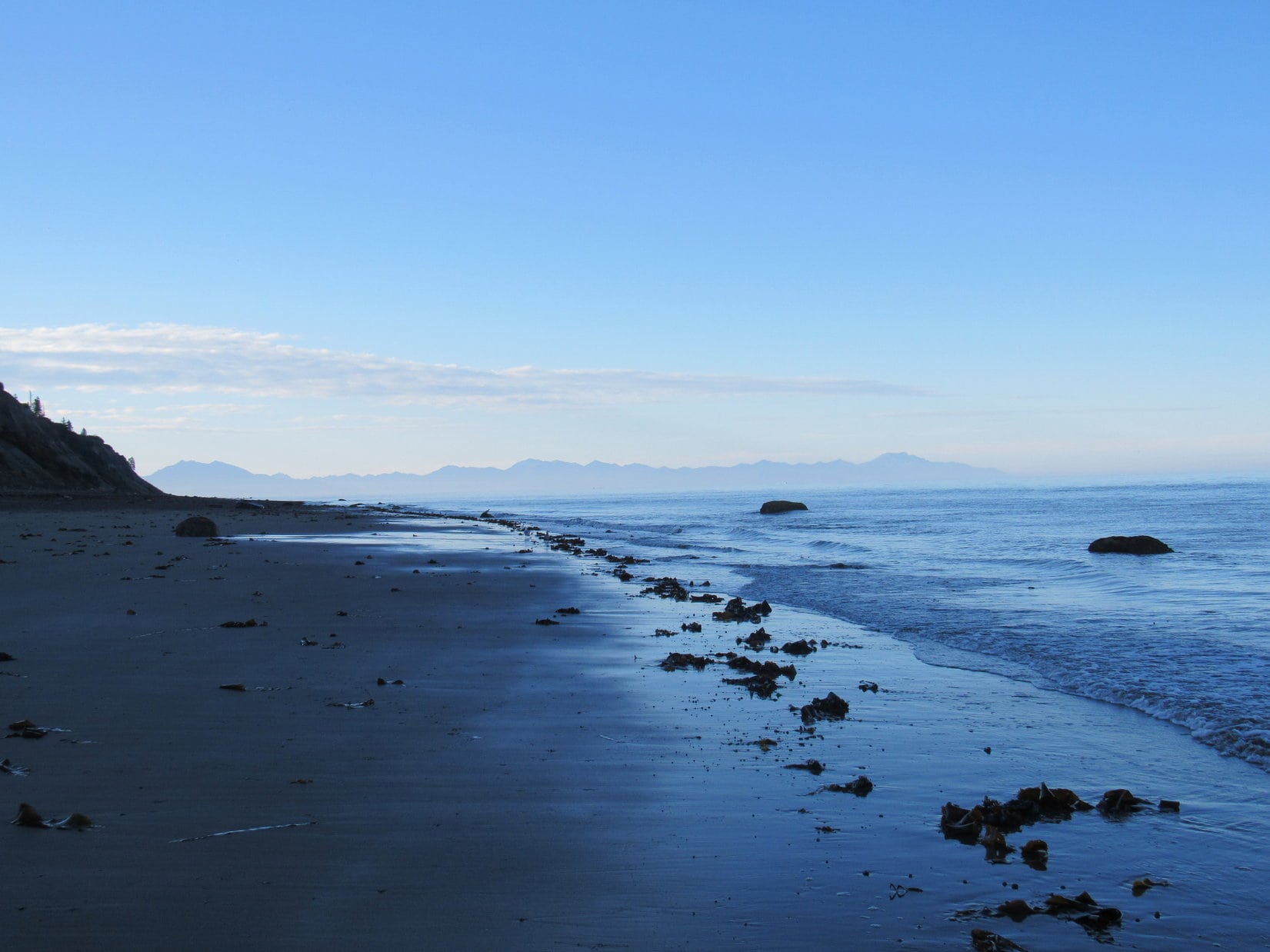
Lupe wasn’t here to search for Captain Cook’s anchor. She was here to reach a personal milestone, one that would likely endure the rest of her life. No road connected to the North American highway system goes any farther W than the road she had just taken to Anchor Point. Somewhere along the gently curving stretch of beach to the S, a mile away or less, was the westernmost point on earth Lupe would ever reach.
Somewhere less than a mile beyond Lupe, this beach reaches its westernmost point and starts curving slightly back toward the E. At that point, Lupe would be as far W as she will likely ever be in her whole life. Photo looks SW.
Despite having had a huge adventure yesterday crossing Kachemak Bay aboard the water taxi XtraTuff to climb Grace Ridge(3,136 ft.), Lupe was energized! She raced along the deserted sand and mud flats exposed by low tide, seagulls swirling overhead. SPHP plodded along after her, enjoying every moment of the exhilarating seaside stroll.
Lupe streaks away over sand and mud exposed by low tide, seagulls swirling overhead. Photo looks S.Whee! Lupe was energized!
The shoreline headed only slightly W of S from where Lupe and SPHP started. It would gradually curve back to true S, and then slightly E of S. SPHP had no way of knowing which particular spot was the farthest point W along Lupe’s route. It would hardly matter, since the entire beach was only marginally farther E than the exact westernmost point.
Lupe posed nicely in the sun for a couple of shots looking W toward the open ocean. If Lupe wasn’t at her westernmost point here, she was very close to it.
Lupe on the shore of Cook Inlet very nearly as far W as she will likely ever be. Photo looks W.
Lupe and SPHP continued S, and perhaps a bit farther W along the shore. Seagulls took flight whenever Lupe or SPHP got too close, only to land again a short distance away to resume strutting about the beach.
Seagulls liked to strut about the beach picking at whatever they found of interest. Whenever Lupe or SPHP got too close, they took off, only to land again a short distance away. Another part of the Kenai Peninsula is seen in the distance, beyond Kachemak Bay. Some of it is farther W than Anchor Point, but access is limited. There are no roads over there. Photo looks SSW.
The exposed beach was very flat. Most of it was quite damp. In some places it was simply muddy. Lupe passed over large patches of seaweed left stranded by the ocean. Strange odors arose from the seaweed. Lupe sniffed to her heart’s content, learning about life in and near the ocean.
Lupe sniffs the strange odors given off by seaweed. Large stretches of the beach were completely covered with it.
Far to the SW, barely visible on the horizon, was another volcano. It was much smaller than Iliamna or Redoubt, and looked blue instead of white. This was Augustine Volcano(4,025 ft.), which sits on an island presumably of its own making, in Cook Inlet.
Augustine Volcano was barely visible on the far horizon. Photo looks SW using the telephoto lens.
Not a soul was around. The shoreline was deserted, except for the seagulls. The fresh ocean breeze blew. Waves rolled endlessly ashore. Lupe explored and sniffed. SPHP continued S. Finally, a long straight stretch of beach was ahead. To the E was a bluff. To the W, several large rocks could be seen at or near the edge of the water.
A busy Carolina Dog explores the shoreline along Cook Inlet. A long stretch of beach was ahead, with a bluff to the E. Photo looks S.Over near the end of the bluff, a few large rocks could be seen close to the shoreline. Photo looks S.
Beyond the bluff, the beach made a more noticeable turn E. If Lupe hadn’t already passed by her actual farthest point W, it was almost certainly near one of those big rocks W of the bluff. That was as far as Lupe needed to go. SPHP christened the largest, most distant rock as the “Rock of the West”.
Approaching the “Rock of the West” (R of Center).
Although the Rock of the West had appeared to be on shore when SPHP first spotted it, by the time Lupe reached it, the tide had come in further. The Rock of the West was now a small island.
This point on the beach was the end for Lupe. She must have been at least a mile from the Anchor Point parking lot by now. More of the Kenai Peninsula across Kachemak Bay to the S was gradually coming into view as Lupe had approached the Rock of the West. Either this was it, or Lupe had already completed her last mile W somewhere along the way.
Here, a few feet from the Rock of the West, Lupe was as far W as she would ever be in her whole life.
Lupe as far W as she will ever be, a few feet away from the Rock of the West at Anchor Point, Alaska. Photo looks W.
Only 13 days ago, Lupe had reached her farthest point N along the Dietrich River nearly 90 miles N of the Arctic Circle. Now she had reached another milestone in life. Both moments were beautiful and wonderful, but also bittersweet.
It was wonderful that Lupe had journeyed so far, and expanded her world so much. She had seen so many new places, and had so many memorable experiences. Yet it was sad to think that this was also an end, a boundary beyond which she would never go.
For a while, Lupe and SPHP stayed together, looking out to sea near the Rock of the West. The same sea encircles the globe. Far beyond the horizon was a world of exotic lands, entire continents to explore. Lupe would never see them.
So, Looper, if you had a ship like Captain James Cook did so long ago, where would you sail? What distant, exotic lands would you explore?
Squirrel island!
Oh, for Pete’s sake! Come on, let’s go!
The return trip along the beach was every bit as relaxing and beautiful as Lupe’s journey to the Rock of the West had been. Sea and sky were blue. Seagulls and mighty volcanoes were white. Boats bobbed on the water or zoomed away over the waves, no doubt in a rush to reach Squirrel Island. Surf exhausted itself uselessly against the edge of North America, but made the most calming, relaxing sound on earth doing so.
Right here, right now, was a glorious place to be!
Iliamna Volcano across Cook Inlet. Photo looks NW.Redoubt Volcano(L) on the way back. Photo looks NW.Blue sky, blue sea. White seagulls, white volcano.Seagulls with a grand view of Iliamna Volcano. Photo looks NW.Augustine Volcano(L). Wouldn’t it have been fun, if Lupe had only had a ship that would have taken her over to the island it’s on? Photo looks SW.American Dingoes are known to roam as far W as Anchor Point, Alaska. They seem to like it here! Photo looks NW.Another boat launched by the tractor gets underway. Redoubt Volcano in the background. Photo looks NNW.Someone sets off in search of fabled Squirrel Island.
Despite an unrushed, easy pace, Lupe’s last mile West hadn’t taken long. By 9:35 AM, she was back at the G6. A major milestone was now behind her, but more adventures were in store, this very day! This afternoon she would be on the Skyline Trail to the Mystery Hills, which certainly sounded like fun.
Yet it would be a long time before Lupe and SPHP would forget the Rock of the West and being here together at beautiful Anchor Point, the farthest W Lupe ever went, standing at the edge of the sea, gazing out toward the world of possibilities that lay beyond the restless waves.
(Start, 9:11 AM, 37°F, West Cascade Mountain Road a few miles S of Hot Springs, SD off Hwy 71.)
Well, that was easy! Except for the cactus, of course. Lupe hated the cactus! SPHP had had to carry her to the summit of Peak4340 for short stretches where the cactus was worst. Fortunately, the summit had only been a couple hundred yards W of West Cascade Mountain Road. Even carting a Dingo around, it had only taken minutes to get here.
Lupe at the summit of Peak 4340. This was actually the first of two high points she found that were true summit candidates. The other one was a couple hundred yards SW of here. Photo looks NW.
The topo map on Peakbagger.com showed only one contour where the true summit of the mountain could be, but things seemed a little different when actually here. SPHP thought another place a couple hundred yards farther SW looked possibly even a little higher. Naturally, Lupe had to visit that high point, too.
Loop at the 2nd possible location of the true summit. Due to the cactus threat, Lupe demanded that SPHP tote her part of the way over here, too. Photo looks S.
The top of Peak 4340 was a large area of gently rolling terrain and open forest, but offered only teaser glimpses of distant views. Close to a rural housing subdivision, it really wasn’t a terribly interesting place. With cactus around, Lupe didn’t think much of it either, but at least she could now cross another Brian Kalet peak off her list. She only had a couple of them left to visit in the southern Black Hills.
Lupe was happy to put a quick end to her visit of Peak 4340, and return to the G6 (9:41 AM, 38°F).
The trivial trek to both possible summits of Peak 4340 was only a warm-up exercise. Lupe had a much more interesting peakbagging goal in store. Flagpole Mountain(4,320 ft.) sits at the far SE end of the Black Hills, N of the Cheyenne River and W of Angostura Reservoir. Lupe might have some fantastic views far out across the prairies beyond the hills from there.
SPHP’s old USFS map showed that Flagpole Mountain was on USFS land, but surrounded by private property. Before Lupe could begin her climb, SPHP needed to find legal access. The shortest route up Flagpole Mountain would be from the SW. SPHP drove S on Hwy 71 intending to scout out the approach.
On the way, Lupe stopped briefly by Cascade Falls. She had been here before, but it’s always fun to see the falls!
Devil’s Slide Mountain(3,965 ft.) from the Cascade Falls picnic ground. Photo looks NE.Cascade Falls is more of a rapids. Wading in Cascade Creek which plunges into a deep swimming hole is a locally popular summer activity. Cascade Falls is only a mile N of the Cheyenne River at the far S end of the Black Hills.Devil’s Slide Mountain from Cascade Creek a little upstream of the falls. Photo looks NE.
For some reason, Cascade Creek always seems to have good flow, no matter what the season. Cascade Falls was looking good today, too, but it was too chilly out to stay and enjoy it. The middle of July is better for that! Lupe and SPHP continued S on Hwy 71.
Just N of the Cheyenne River, a gravel road headed ESE from Hwy 71. The road wound around to the SE for more than a mile. It deteriorated at the end of a short stretch that went E. A log-sided home was on the N side of the road. Before SPHP even got out of the G6, a man opened the door of the house.
His name was Mike. When SPHP told Mike that Lupe would like permission to cross his land to climb Flagpole Mountain, the answer was flatly “no”. Mike didn’t exactly come right out and say it, but his attitude was clearly “Get Off My Property”. Mike didn’t want to talk about it. The matter was not up for discussion.
Mike was still helpful, however. He told SPHP that 5 or 6 years ago, the state of South Dakota had purchased land leading to the national forest on the other side of the mountain. Lupe would have legal access from Sheps Canyon.
That was good news! Well, at least pretty good news. Sheps Canyon was an alternate route that SPHP had intended to check on if things didn’t work out here. The route to Flagpole Mountain from Sheps Canyon would be a lot longer than if Lupe had been able to start from Mike’s ranch.
No is no. SPHP thanked Mike for the tip. Lupe left his property.
Driving down Sheps Canyon was not initially encouraging. Lupe passed by housing developments and more ranches. “No Trespassing” signs were all along the S side of the road at frequent intervals. Lupe was all the way down to the lower end of the canyon not too far from Angostura Reservoir before SPHP spotted the Hill Ranch Game Production Area. This had to be the legal public access Mike had mentioned!
Lupe at the entrance to the Hill Ranch Game Production Area. This entrance is easy to spot on the S side of Sheps Canyon Road in the lower part of the canyon. Photo looks SSE and was taken late in the day.The Hill Ranch Game Production Area is mostly used by hunters, but is open to public access for other uses like hiking, too.
A good dirt and gravel road led into the Hill Ranch GPA. SPHP parked the G6 at a curve at the far E end of the road only a short distance from Sheps Canyon Road (10:48 AM, 43°F). Lupe could regain her confidence trotting along the cactus-free road for a while.
The road went steadily uphill at a moderate pace, heading W for the most part. Lupe passed by a parking pullout and then a small lodge. The lodge appeared to be closed. A couple of parking pullouts farther, Lupe had quite a good view of Angostura Reservoir.
Angostura Reservoir from the Hill Ranch GPA. Photo looks E.
The road went 2 miles before ending near a couple of gates at the edge of the national forest. (Even the G6 would have made it this far easily enough, if SPHP had chosen to drive to this point.) A map of the Hill Ranch GPA was posted here.
This map of the Hills Ranch GPA was posted at the end of the road. The national forest was just W of here beyond a couple of gates.
Lupe went through the smaller gate, continuing W into the Black Hills National Forest. The good road was behind her. She followed faint traces of an old jeep trail, still gaining elevation steadily.
Angostura Reservoir is still in view as Lupe continues W now on Black Hills National Forest ground. Photo looks E.
A ridge coming in from the ENE soon merged with the ground Lupe was traveling. Shortly after that, she came to a place where she had a great view to the N. She could see Peak4310, which she had visited only a couple of expeditions ago. Today the scene wasn’t all snowy like it had been then.
Lupe reaches the first viewpoint to the N. Peak 4310 is the barren distant high point extending farthest toward the center of the photo from the R. Lupe had been there only 2 expeditions ago. Photo looks N.
From this first viewpoint looking far to the N, the faint trail turned SW. It soon came to a saddle between two hills. Flagpole Mountain was in view!
Flagpole Mountain (Center) came into view at a saddle between two hills. It was only 1.5 miles away, but Lupe would have to go a lot farther than that to get there. Green Canyon was in the way! Photo looks SW.
Flagpole Mountain was only 1.5 miles off to the SW when Lupe first saw it. However, she would have to go a lot farther than that to get there. Green Canyon was in the way.
To get to Flagpole Mountain, the plan was to go around the W end of Green Canyon. Lupe would follow a couple of long ridges shown on the topo map. The first ridge went first W then NW for nearly 1.5 miles. The map showed a substantial part of this ridge as being very skinny. SPHP wasn’t certain what Lupe might encounter along the way.
Lupe turned W and started around the S side of the highest little hill in this area. The hill was the first part of the ridge leading W. The ridge wasn’t narrow here, but going around the S side of the hill quickly proved to be a mistake. The grassy open ground below the forested summit was full of cactus! Lupe was immediately seized with fear.
Although the hill wasn’t all that big, it took a while to get past it. Lupe was scared to move. The cactus had her mentally paralyzed. SPHP had to carry her repeatedly.
Once beyond the hill, the ridge narrowed considerably, but was still plenty wide. Cactus continued to be a near constant problem, but Lupe gradually made progress. SPHP had to carry her less and less.
Nearly a year ago, Lupe had developed a system on her way up Matias Peak(4,780 ft.) for dealing with cactus. She would wait in one spot while SPHP scouted the area ahead. When SPHP sat down, she considered it a signal that all the ground to that point was cactus-free. She then came running.
Now Lupe wanted SPHP to do the same thing. Doing a good job of scouting was important, so Loop would continue to have confidence in the system. This process was sort of slow, but much easier than carrying the Carolina Dog any significant distance. Stop, scout, go. Stop, scout, go. Lupe progressed along the ridge.
Lupe wasn’t any closer to Flagpole Mountain yet, but the route was beautiful. Loop could see Flagpole Mountain almost the entire time. She often had grand views to the N, or down into Green Canyon. She came to a place with huge boulders, and many more places with interesting rock formations. The route was up and down, but none of the elevation changes were too drastic.
Another look to the N from the ridge Lupe was following W.Looking across Green Gulch. The high point seen straight up from Lupe is not Flagpole Mountain, but Lupe would go by it on her way there. Photo looks SW.
The part of the ridge that angled NW was the skinniest. Up and down one narrow little hill or rock formation after another. At one point, Lupe had to do a teensy bit of scrambling, but only once and it hardly amounted to anything. Eventually, the much, bigger, wider hill at the NW end of the ridge came into view. Lupe was almost there!
The much bigger, wider hill at the NW end of the ridge came into view. Lupe was getting there! Photo looks NW.
Soon she was there. Lupe didn’t go quite all the way to the top. She stayed in the trees a little S of the summit. Loop went over to the W edge of another ridgeline heading S from here. She had her first look at a vast new territory to the W and SW.
Lupe could see a vast territory off to the W and SW after reaching the big hill at the NW end of the long ridge she had been following. Photo looks SW.
Going 1.5 miles along the skinny W and NW ridge hadn’t brought Lupe any closer to Flagpole Mountain as the crow flies, but she was now past the W end of Green Gulch and could turn S. A much broader ridge went SSW from here. The W edge of this ridge dropped steeply, but sloped much more moderately toward Green Canyon to the E.
Going S meant traversing several more drops and hills along the way. These were larger than the bumps Lupe had gone over along the skinny ridge, but she didn’t have climb to the top of each one. At the bottom of the first drop was good news. A dirt road climbed up to this point from the W. It turned S here, just the direction Lupe needed to go. Lupe could follow the road!
Reaching the road quickly restored Lupe’s confidence. She wasn’t afraid of cactus on the road. Suddenly she was making great progress. SPHP didn’t have to carry her, or play the scouting ahead game at all. Lupe trotted right along. It wouldn’t take her long to get to Flagpole Mountain at this pace!
Lupe was able to follow this road on the big ridge heading SSW. Unafraid of cactus on the road, she was making great progress! Her destination, Flagpole Mountain is in view on the L. Photo looks SSW.
The road stayed E of the top of the ridgeline most of the time, but was occasionally near it. At once place, Lupe went over to the W edge for another look at the big views.
The weather had been changing in the short time she’d been traveling S. The light NW breeze present earlier, had turned into a gale! Lupe did not like the fierce wind at the W edge of the ridge, but the views were still excellent.
Lupe did not like the fierce NW wind now gusting up the W side the of ridge, but the views were still excellent! The near slope is part of Horseshoe Bend. Photo looks W.Looking WNW.
The helpful road Lupe had been following ended a little before reaching the S end of the ridge, but had brought the Carolina Dog a long way. She was getting close to Flagpole Mountain, but now nervous about cactus again. She was right to be. More patches of dreaded cactus were scattered here and there. SPHP had to resume cactus scouting operations. Once again, Lupe got carried over the worst of it.
For the last 0.25 mile to the summit, the ridgeline turned SE. Lupe was high on broad open terrain where she had expansive views to the S. To the N was forest. The sight of several deer running on another minor ridge excited her so much she forgot all about the cactus and dashed about unsure how to get over there. Fortunately, she didn’t run into any cacti.
The top of Flagpole Mountain(4,320 ft.) appeared ahead. A short, grassy slope led to a summit crowned by big rocks, bare bushes and a few pine trees. In a flash, Lupe was there. She stood on the highest boulders at the very SE end of the Black Hills with a grand sweeping view of miles and miles of desolate territory stretching to the horizon.
Lupe reaches the summit of Flagpole Mountain! Photo looks ESE.Despite a long, winding route, countless cacti, and a wild NW wind, a bold American Dingo stood atop Flagpole Mountain for the very first time. Photo looks ESE.The grand view to the SW. Lupe had hoped to come up the mountain from this direction, which would have been a much shorter trek, but she was refused permission to cross Mike’s ranch. Part of Coffee Flat near the Cheyenne River is seen far below. Photo looks SW.Neither wind, nor miles, nor cacti can keep an American Dingo from its appointed peakbagging! Looper atop Flagpole Mountain. Photo looks SW.A series of snow squalls swept over Flagpole Mountain while Lupe was here. Another one is on its way. Each time a squall hit, Lupe took refuge at the base of these rocks, where she was sheltered from the raging NW wind. Photo looks WNW.
Although partially protected by pines trees to the N, the top of Flagpole Mountain was windy. A powerful NW wind was blowing a series of snow squalls over the mountain. Each time a line of clouds passed over, a brief, but exciting snowstorm developed. The wind raged at the height of its fury beneath an ominous sky.
When the squalls hit, Lupe took shelter at the base of the big rocks at the S end of the summit. She nestled on SPHP’s lap, wrapped in a fuzzy blue pullover sweater, enjoying the incredible views and dramatic weather.
Lupe relaxes sheltered from the wind as she awaits the start of the next exciting snow squall. Photo looks S.The next snow squall begins. Photo looks S.
Though each squall was exciting and began impressively, the snow flakes were tiny and melted as soon as they hit the ground. The squalls never lasted more than a few minutes. Gorgeous blue skies reappeared as soon as they were over, and the winds calmed down somewhat.
Between squalls, Lupe explored the summit area, while SPHP enjoyed the views from various vantage points. By going only a little down the S or SE side of the mountain, it was possible to almost entirely escape the wind. The day felt pleasant, warm and sunny.
Looking ESE toward the SW end of Angostura Reservoir. The Cheyenne River can be seen flowing into it from the R.Lupe back on the summit of Flagpole Mountain between squalls, though another one is in the works. Photo looks WNW.Your Carolina Dog guide to the Black Hills on another mountaintop! Photo looks WNW.Looking down on Coffee Flats (R) next to the Cheyenne River. The more distant flat, grassy highland on the L is Stage Hill. Photo looks SSW with a little help from the telephoto lens.Between snow squalls, the skies cleared to a gorgeous, fresh blue. Photo looks NW.
Lupe and SPHP stayed for an hour or more at the summit of Flagpole Mountain. Although the trek here had been amazing and beautiful, the presence of so much cactus meant it might be a long time, if ever, before Lupe would return. These distant views beyond the Cheyenne River across the vast, lonely prairies were a rare treat.
Taken from the summit of Flagpole Mountain, this photo looks SE down toward Tepee Mountain(3,790 ft.), the low forested ridge on the R beyond the Cheyenne River.Looking W from the summit.Lupe a little SE of the summit (R). Photo looks W.The SW end of Angostura Reservoir is in the distance on the L. The Cheyenne River flows into it from the R. Photo looks ESE.A closer look at where the Cheyenne River flows into Angostura Reservoir. Photo looks ESE using the telephoto lens.Distant snow squalls sweep the plains of western South Dakota beyond Angostura Reservoir. Photo looks E.Lupe at the far SE end of the greater Flagpole Mountain summit area. The low, darkly forested ridge is Tepee Mountain(3,790 ft.), which lies just on the other side of the Cheyenne River. Photo looks SE.Flagpole Mountain had a few cacti down the SE slope. Here Lupe waits for the all clear signal from SPHP before feeling safe to come this way. Photo looks S.Forest hid the views to the N from Flagpole Mountain’s summit, but by going down the SE slope a little way, Lupe came to this great viewpoint. (It was very windy here!) The long W and NW ridge she had taken on her way to Flagpole Mountain is seen extending nearly all the way across the photo. On the way back, Lupe would have to traverse it again going from L to R. Photo looks N.
An hour went by. It had been a while since the last snow squall had blown through. Apparently they were all over and done with. Sadly, it was time for Lupe to leave Flagpole Mountain. She had to take the same long route all the way back to the G6.
On the way back, SPHP took a few minor shortcuts, but they saved only a little time. More time was saved by staying on the N side of slopes where there were fewer cacti. Lupe’s increased confidence in SPHP’s cacti scouting skills saved the most time of all. She still appreciated being carried for short distances wherever the cacti was worst.
The trek back along the ridges was beautiful, and went faster the second time around. Lupe had time to stop and sniff the air at various places along the way.
On the way back, Lupe took the road going N along the first wider ridge. One of the bigger hills along this route is in view ahead. Lupe didn’t have to go all the way to the top of the hill. The road went around the E (R) side of it. Photo looks N.Looking down on Horseshoe Bend (the near slope) NW of Flagpole Mountain. Photo looks WNW.Looking over Horseshoe bend. The Cheyenne River is seen in the distance. The Cheyenne flows into South Dakota from Wyoming and winds around the S end of the Black Hills on its way to Angostura Reservoir. From Angostura it flows NE all the way to the Missouri River. Photo looks W.Making progress around Green Canyon. The S (R) side of the little high point L of Center is where Lupe encountered the worst of the cactus on the whole trek to Flagpole Mountain. On the way back, Lupe stayed in the forest going around the N (L) side of the hill. She came to a few snowbanks there, but almost no cacti. Definitely the way to go! Photo looks ENE.A final look back at Flagpole Mountain (seen above Lupe) from the area of big boulders on the first ridge Lupe had taken W, then NW. Photo looks SSW.In the area of big boulders. Lupe had originally reached this area fairly early on her way to Flagpole Mountain, but here she’s on her way back to the G6. Photo looks WNW.Looking N on the way back. Peak 4310 is the high bare ridge extending farthest toward Center from the R.
Lupe’s cactus worries were all behind her before she even reached the good dirt road at the Hill Ranch Game Production Area. The rest of the trek was a long, relaxing downhill stroll all the way. Lupe stopped by the same boulder with a view of Angostura Reservoir again.
Back in the Hill Ranch GPA, Lupe stopped by the same boulder with the view of Angostura Reservoir again. It was still windy out. Photo looks E.
Lupe was content to trot along the good road all the way through the Hill Ranch GPA to the G6 (5:38 PM, 37°F). Her Flagpole Mountain adventure was over, but it was the first day of Daylight Savings Time in 2017. The sun would still be up for another 1.5 hours.
SPHP used the extra hour of evening daylight to drive Lupe down to Angostura Reservoir. She had seen it from afar from several different mountains on recent expeditions. Now she would get to see it up close.
The drive was beautiful. SPHP was surprised to find a good gravel road winding S for miles along the W shore of the lake. Lupe stopped at a boat ramp. The wind was out of the NE here and still strong. The temperature was in the 30’s and dropping. It felt cold out. Waves crashed into the shore. Lupe drank a little water out of the lake, then got up on the swaying dock. Tepee Mountain, which she had seen earlier from Flagpole Mountain, was in view in the distance.
Lupe at Angostura Lake for the first time ever after having seen it in the distance from several mountains on recent expeditions. Tepee Mountain is in view in the distance. Photo looks SW.
SPHP was curious. How far did this road go? Lupe and SPHP drove farther SW. The road went by many great campsites up on the bank above the shore of the lake. Lupe stopped at another place offering lake access.
Looking NE across Angostura.The view to the SE.Looking SW.
Lupe and SPHP drove all the way to the end of the road. Surprisingly, at the end was a horse camp. Maps and information at the horse camp said a riding trail went 5.1 miles farther along the lake and up the Cheyenne River. Horses were restricted to the trail while in the Sheps Canyon Outdoor Recreation Complex, but the trail went all the way to the Black Hills National Forest, where horses could be ridden anywhere.
It was a beautiful area. The trail along the lake and up the river would be an awesome place to ride horses. Once to the national forest, maybe horses could even climb Flagpole Mountain? One thing was for certain, an American Dingo could!
With a new route to explore, maybe someday a Carolina Dog will stand in the breeze far above the Cheyenne River on Flagpole Mountain again.
Day 28 of Lupe’s Summer of 2016 Dingo Vacation to the Canadian Rockies, Yukon & Alaska
Ugh, what is it Loop? What now? Lupe kept pawing at SPHP. Oh, Loopster, what do you want? Do you need out? … 7:00 AM! … Oh, my gosh, Loop! Thanks for waking me up! We’ve got to get going!
Lupe may have just saved the day. SPHP meant to be up an hour ago. The sun was already above the horizon. Was there still time? The day was perfect – clear and bright, as SPHP drove out to the Homer Spit.
Narrow Homer Spit protruding 6 miles into Kachemak Bay was awesome! Hundreds of boats of all descriptions were moored in a gigantic pack on the protected NE side. Sea gulls whirled overhead. The one road along the spit was lined with restaurants, colorful tourist shops, and fishing and sight-seeing charter businesses. People were up and about. The whole place hummed with activity.
SPHP drove slowly, looking for Homer Ocean Charters. There it was, on the SW side of the street! SPHP parked and went in, while Lupe waited in the G6. SPHP asked the lady at the counter about getting a water taxi ride over to Grace Ridge in Kachemak Bay State Park.
The good news was that dogs were welcome, and Lupe could come along for free! The bad news was they had a 2 person minimum requirement. Grace Ridge wasn’t that popular. They had no one else scheduled to go to Grace Ridge today. The lady suggested either a different destination, or trying Mako’s Water Taxi across the street.
Mako’s wasn’t right across the street, although it wasn’t far away. It took SPHP a few minutes to spot it. Once again, Lupe waited in the G6 while SPHP went in, a little fearful of another negative response. Mako’s was busy. It took a few minutes for SPHP’s turn to come. Another woman behind a counter asked what SPHP wanted.
Water taxi service to Grace Ridge? They had only one group scheduled for Grace Ridge today. Three people were leaving right now. Round trip price was $81 plus tax (total a bit over $91). Pickup at 6 PM. Lupe could come along, no extra charge. Was now OK?
Perfect! Now was absolutely perfect! SPHP paid up, then ran out to move the G6 to free parking a couple blocks away next to the Homer Grill. As SPHP and a somewhat alarmed Lupe started running back to the dock, Mako’s captain of the water taxi XtraTuff was already yelling at SPHP to hurry up. When Mako says now, they mean NOW! They were leaving!
Lupe on Homer Spit, moments before dashing off to catch a ride to Grace Ridge on Mako’s water taxi XtraTuff. Photo looks NE.
Lupe was afraid of the open metal grate dock. She could see the water below her. SPHP picked the surprised Carolina Dog up, and ran carrying her to the XtraTuff. Moments later, she was aboard. Immediately, the captain put the engine into reverse, and started easing the XtraTuff away from the dock. Lupe and SPHP sat out in the open air on a bench in the front of the boat.
Sea dog, Loopster, aboard Mako’s water taxi XtraTuff, embarks from Homer Spit to sail across Kachemak Bay of the North Pacific Ocean on her way to Grace Ridge! Photo looks NW.
The XtraTuff cruised slowly, leaving little wake, while maneuvering around all the other boats on the way out of port. The XtraTuff picked up a little speed once it was clear of the moored boats. The captain steered SE toward the end of Homer Spit.
Lupe aboard the XtraTuff nearing the SE end of Homer Spit. Grace Ridge is in view above the 2nd support from the L. Photo looks S.Rounding Homer Spit. Grace Ridge on the L. Photo looks S.
As the XtraTuff rounded Homer Spit and headed out across Kachemak Bay, the captain put her in high gear. XtraTuff was fast! The water taxi bounded across the waves.
Even though the sea wasn’t that rough, it was a bumpy ride. Every now and then XtraTuff hit a wave with a jarring jolt. The morning’s cool breeze became rather chilly, as the XtraTuff raced toward Eldred Passage. SPHP hung onto Lupe, so there wouldn’t be an American Dingo overboard.
On Kachemak Bay heading for Eldred Passage. Photo looks SSW.
The captain asked if Lupe and SPHP would like to come in the enclosed cabin to get out of the cold wind. Thanks, but hell no! This was what Lupe had come for! Here she was, bounding across Kachemak Bay of the North Pacific Ocean on her way to Grace Ridge(3,136 ft.) in Alaska with fabulous views everywhere. This was exciting! This was glorious!
Mountains along Kachemak Bay. Photo looks SE.Approaching Yukon Island (Center) aboard the XtraTuff. Photo looks SSW.OK, SPHP, we’re way out here now. So level with me, what the heck are you getting us into?Grace Ridge from Kachemak Bay aboard the XtraTuff. Photo looks S.In Eldred Passage on the way to Tutka Bay. Billy, one of the other passengers, later told SPHP that the sharp peak on the L is called Broken Knife, although SPHP doesn’t find that name on any map. Photo looks SSW.
The Grace Ridge Trail is 9 miles long. Lupe was going to take the entire trail from one end to the other, making only a single traverse. A water taxi would pick her up at the other end. SPHP had a choice of where to get dropped off. At the N end, closest to Kachemak Bay, is Kayak Beach. The more remote S trailhead is along the NE shore of Tutka Bay. The other 3 passengers were going to the S trailhead. SPHP told the captain that was where Lupe wanted to be dropped off, too.
The XtraTuff raced over smoother waters through Eldred Passage. Lupe passed by the entrance to Sadie Cove to the E. XtraTuff sailed S around the NW end of Grace Ridge. Entering Tutka Bay, XtraTuff was still making great time. After a few miles, though, a dense fog bank was dead ahead right on the water.
The captain slowed XtraTuff to a crawl as Lupe entered the fog. Everything disappeared from view. The drop-off point wasn’t much farther. XtraTuff crept cautiously forward, the captain straining to see something, anything. After 5 minutes, a tiny beach appeared close by and directly ahead. The captain had found it! This tiny beach was the Grace Ridge S trailhead.
XtraTuff glided into shore. Lupe, SPHP, and the other 3 passengers disembarked. It only took a minute. As the XtraTuff backed slowly away, everyone waved and thanked the captain, who waved back. XtraTuff disappeared like a ghost.
XtraTuff about to disappear into the fog on Tutka Bay. Photo looks, uh, well, let’s see, NW maybe?
Wow! Incredible! If the 3 other passengers hadn’t been here, this place would have been just plain spooky. A dark, dense, primeval forest extended right down to the tiny beach at water’s edge. Leafy ferns, thick clumps of moss, ancient trees. In the fog, it all looked unnervingly prehistoric. It could have been 10,000 years ago, maybe 10,000,000 years ago. What was out there? Bears? Dinosaurs!? Lupe was lost in time.
Lupe lost in time, and looking a tad concerned about it, at the South Grace Ridge trailhead.
The other 3 passengers seemed to know where they were. They set right off, following a good single track trail through the jungle. The trail gained elevation slowly at first, but soon started switchbacking up a steep slope. Lupe and SPHP followed the rest of the group, trailing a little behind.
So far, so good. No bears or dinosaurs yet.
The fog bank was dense, but wasn’t all that thick. Soon Lupe was getting up high enough to where sunshine could be seen filtering through the trees. The other 3 XtraTuff passengers set a fairly brisk pace. Lupe and SPHP continued following along behind.
As Lupe climbed above the fog, sunlight began filtering through the trees.
The trail was good. The switchbacks made the pace of elevation gain moderate. Lupe was making great time and gaining elevation steadily. The rest of the group was traveling almost too fast for SPHP’s taste. What was the hurry? Lupe had been dropped off at the S trailhead around 9 AM. She didn’t need to be at the N trailhead until 6 PM, 9 hours later. Since the trail was only 9 miles long, she only had to travel one mile per hour.
Soon everyone, except Lupe, was sweating. The group stopped for a break. SPHP stripped down to a T-shirt. The woman of the group introduced herself as Sandy. With her were Kevin and Billy. They were all friendly, but spent much of their time deeply engaged in their own conversations. They were friends who all live in Homer, as near as SPHP could gather.
Everyone set off again. The rapid pace continued. Lupe and SPHP lagged behind when Lupe found, not a bear or a dinosaur, but a squirrel in the forest. A brief, enthusiastic barkfest ensued. A bit later, Lupe and SPHP caught up with the group again. As Lupe gained elevation, the primeval forest gave way to a more normal looking forest minus all the moss and ferns. The normal forest then began to thin out, with some of the tall bushes common in Alaska starting to take over.
There were other people on the trail! The XtraTuff group overtook and passed a family of four. Soon after that, Lupe got her first look at a barren high point ahead.
As the Grace Ridge Trail neared the ridgeline, Lupe got her first look at a barren high point ahead. Photo looks NNW.
The trail reached the ridgeline. The switchbacks were done. From now on, the trail would stay up on the ridgeline following it all the way NNW to the summit. Tall bushes and scattered trees dominated at first, but that didn’t last long. The moderate pace of elevation gain enjoyed while on the switchbacks was over. The trail climbed steeply, quickly bringing Lupe up above all the tall vegetation.
The American Dingo wasn’t anywhere near the summit of Grace Ridge yet, but truly awesome views were opening up all around.
Tutka Bay, which Lupe had come sailing over on the water taxi XtraTuff on her way to the Grace Ridge S trailhead. The broader expanse of Kachemak Bay is seen in the distance. Photo looks WNW.Looking down at the S end of Sadie Cove, which borders Grace Ridge to the N and E. Photo looks SE.Lupe on the Grace Ridge trail having reached the first high point along the ridgeline above all the trees and tall bushes. Photo looks SSE back down along Grace Ridge. Part of Tutka Bay is seen on the R.
Ahead, Grace Ridge was covered only with alpine tundra. A marvelous ridgeline trek of sweeping unobstructed panoramas was in store for Lupe. The Carolina Dog still had a long way to go to reach the summit. It wasn’t even in view yet.
Ahead, a marvelous ridge hike over alpine tundra was in store for Lupe. The summit was still far off. It wasn’t even in view yet. Photo looks NNW.
From her vantage point high on Grace Ridge, Lupe was now able to see great distances over the tundra. She saw something move far below. Suddenly, Lupe took off straight down the steep W slope toward Tutka Bay. SPHP called her, but she disappeared over the edge of an embankment. She had lost hundreds of feet of elevation in hardly any time at all! SPHP kept calling her.
After a few minutes, here came the American Dingo, charging straight back up almost as fast as she had gone down. Lupe arrived with a long pink tongue dangling from her mouth, panting as though she might burst. Did she ever look happy, though! Wow, what would SPHP give to be in that kind of shape? Simply amazing! However, Lupe was now under orders not to go running off like that again. SPHP never did see whatever it was she chased after.
Lupe and SPHP had fallen a little behind the XtraTuff group, but caught up with them again between two small rocky hills where they had stopped for a snack. Up on the exposed ridgeline, an E breeze was blowing, but between these small hills the trail was protected from the wind.
While everyone was still eating, Lupe climbed up the small hill on the E side of the trail for a look around. The views were getting better! Lupe could even see Iliamna Volcano(10,016 ft.) faint and far away across Kachemak Bay and Cook Inlet to the NW.
Lupe up on the small rocky hill E of where the XtraTuff gang stopped for a rest break. A small part of Sadie Cove is seen on the lower L. The highest peak on the L may be Sadie Peak(4,320 ft.). Photo looks SE.The views kept getting better as Lupe gained elevation. This photo looks S farther into Kachemak Bay State Park.Lupe back down in the sheltered area near the trail. The rest of the XtraTuff gang has already finished their break and moved on. Iliamna Volcano is seen very faintly far across Cook Inlet to the L of Lupe. Photo looks NW.
When the rest of the XtraTuff group moved on, Lupe and SPHP stayed at the sheltered spot between the two hills. Everyone else seemed to be in a hurry to get to the summit. No reason for it that SPHP could see. Lupe had plenty of time.
SPHP had asked how much more elevation was left to be gained. Sandy, Keven and Billy had all insisted Lupe was only halfway up, but that seemed to be a gross underestimate of the progress already made. Lupe must have gained at least 67% of the 3,136 feet required to reach the summit. Probably more like 75% or even 80%.
After a nice break, Lupe and SPHP continued on. The trail remained good. The route was obvious, in any case. The exposed ridge hike was a ton of fun. Fantastic views everywhere, all the time. After passing through a dip into a big saddle, there was one more fairly long steep climb.
Lupe near the top of the next big climb. Tutka Bay is seen below. The mountain Billy called Broken Knife is on the R. SPHP wonders if it isn’t really Red Mountain(3,524 ft.), though the name would make more sense for the more distant tan colored peak seen straight up from Lupe. Photo looks SW.
Grace Ridge’s easily recognizable big summit ridge came into view ahead. There was no mistaking it. The trail headed straight for it, passing over several prominent high points. This part of the ridge was often narrow and steep.
Grace Ridge’s easily recognizable big summit ridge(R) came into view. To get there, Lupe followed the trail up and down over several high points. Along the way, the trail was often steep and the ridge quite narrow.How’s this for a view, SPHP? I’m not even at the summit yet! Kachemak Bay from Grace Ridge. Photo looks WNW.
Beyond the last of the prominences, Lupe had an unobstructed view of the big summit ridge running SE/NW ahead. Getting there was going to be a piece of cake. The ridgeline became much wider here. The trail would take Lupe up to the SE end of the summit ridge. The true summit of Grace Ridge was a knob of rock relatively close to that end. Lupe was almost there!
From the last prominence, Lupe had an unobstructed view of Grace Ridge’s big summit ridge ahead. The trail would take Lupe to the SE (R) end. From there it wasn’t far to the true summit, the small knob of rock seen a little to the L.Lupe at the last of the prominences prior to going on to the summit ridge. Sadie Cove is seen below on the L. Photo looks SSE.Looking SSE using the telephoto lens.
Fifteen minutes later, Lupe was up at the SE end of the summit ridge. While it had been breezy down along the lower ridge, it was just plain windy up here. The E wind was strong! Lupe didn’t like the wind one bit, but tried to wait patiently for SPHP to finish loitering around.
Lupe found a survey benchmark(R) at the end of a long pipe at the SE end of Grace Ridge’s big summit ridge. The near ridge in view is on the other side of Sadie Cove. Part of Kachemak Bay is in the distance on the L. Photo looks NE.Peaks of Kachemak Bay State Park. Photo looks NE using the telephoto lens.Lupe enduring the wind at the SE end of the Grace Ridge summit ridge. Photo looks SW.The survey benchmark at the SE end of the Grace Ridge summit ridge.Looking SSE back the way Lupe came up. Sadie Cove is on the L. The survey benchmark is at the lower L corner. A windswept Carolina Dog is on the R.
The true summit of Grace Ridge was only 200 yards away. Sandy, Kevin and Billy were all over there, sitting below the SW side of the summit sheltered from the wind. Lupe was going to get a lot more fresh air on her way over there.
The true summit of Grace Ridge is seen only 200 yards away to the NW. Sandy, Kevin and Billy were already over there taking shelter from the wind. Photo looks NW.
Of course, before rejoining the rest of the XtraTuff gang, Lupe had to climb up on top of the true summit to claim her windy Grace Ridge peakbagging success!
Lupe reaches the true summit of Grace Ridge in Alaska’s remote Kachemak Bay State Park! Photo looks NW.Skinny Homer Spit is seen extending 6 miles into Kachemak Bay. Photo looks NNW from the true summit of Grace Ridge.Mighty Loopster astride the true summit of Grace Ridge. Photo looks NW.
Kachemak Bay from the summit of Grace Ridge. Photo looks NNE.Homer Spit again, this time using the telephoto lens. Photo looks N.Looking SSE. Lupe’s route up was along the barren hilly ridgeline seen on the R.
Lupe was glad to get down off the true summit to take refuge from the wind on the SW side of the big rock outcropping. Sandy, Kevin and Billy were still relaxing and finishing up lunch there for a little while longer. They said it was noon, which meant it had taken Lupe only 3 hours to get here from the S Grace Ridge trailhead. Lupe had 6 whole hours until she needed to be down at the N trailhead for the scheduled water taxi pickup at Kayak Beach.
Before long, the rest of the XtraTuff gang moved on. Lupe and SPHP stayed alone, enjoying the solitude and the magnificent scenery. The family of 4 that had been passed on the way up came by, continuing farther NW along the summit ridge. For more than half an hour, Lupe and SPHP did not stir from the sheltered spot below the summit. What a magnificent place! Eventually, though, the time came to start exploring the big summit ridge.
The view to the SW from the sheltered spot where Lupe relaxed out of the wind just below the summit. Tutka Bay is down below.
First, Lupe returned to the SE end of the summit ridge near the survey benchmark. The views of the mountains to the S were best from this end of the ridge. Lupe and SPHP wanted to see them from this vantage point one more time before leaving.
Looking SE using the telephoto lens.Worth a second look, aye?Looking SSE.Sadie Cove and Sadie Peak(L). Photo looks SE.Lupe rests on the tundra near the SE end of Grace Ridge’s big summit ridge. The true summit is on the R. Tutka Bay is on the L. Photo looks WNW.
Bidding farewell to the S mountain views, Lupe headed NW, passing by the true summit for the final time.
Grace Ridge’s big summit ridge is about 0.25 mile long. Unlike the lower SSE ridge Lupe followed to get here, which was narrow and steep in some places, the big summit ridge is broad and flat to gently rolling. No clear trail exists most of the way, but the general route is totally obvious. If you still don’t get it, NW of the true summit the route is marked by a series of big cairns.
Tutka Bay. A fog bank hangs over adjoining Kachemak Bay. Photo looks WNW.Lupe NW of the true summit, seen on the L. Of course, American Dingoes can find their way across this broad, gentle ridge with their eyes closed. Huge cairns showed SPHP the way. Photo looks SSE.
Going NW along the big ridge, Lupe was heading away from the mountains and toward the ocean. There was one impressive mountain view, however, which she was going toward. Faint and far away, beyond Kachemak Bay and Cook Inlet, was Iliamna Volcano(10,016 ft.).
Naturally, faint and far away aren’t normally associated with impressive. A look through the camera’s telephoto lens told a different story.
Iliamna Volcano from Grace Ridge. Bring those binoculars, if you want to see it looking like this instead of simply faint and far away. Photo looks NW.
A 0.25 mile long summit ridge is a pretty big summit, but even at a very leisurely pace with stops to sniff and admire the views, it took Lupe only half an hour to reach the NW end where the best ocean views were.
Lupe near the NW end of the big summit ridge. Photo looks back to the SSE. The true summit is seen on the L.At the NW end. Photo looks WNW.Anchor Point along Cook Inlet is in view here beyond Kachemak Bay. Photo looks NW.Iliamna Volcano towers above low clouds covering Cook Inlet. Photo looks NW using the telephoto lens.Anchor Point from the NW end of the Grace Ridge summit ridge. And, hey, isn’t that the peakbagging Carolina Dog from the Black Hills of South Dakota up there?! Photo looks NW.
Lupe and SPHP had first reached the SE end of the Grace Ridge summit ridge an hour and forty minutes ago. If the wind hadn’t been so strong, Lupe would have remained at least another hour. However, as wonderful as the views were, the wind was wearing enough to make starting down sound like a good idea.
A final look back at the true summit of Grace Ridge(R) before starting down. Sadie Peak is seen R of Center. Photo looks ESE.Homer and the Homer Spit across Kachemak Bay. Lupe’s route down off Grace Ridge started toward the R in the direction of the cairn. Photo looks N.
The wind soon abated as Lupe lost elevation, a welcome development as far as she was concerned. Going down the NW end of Grace Ridge was a lot different from coming up the SE end. Lupe was facing views of the ocean. The trail going down didn’t follow any distinct ridgeline, but wound around in open country.
Lupe in open country on her way down. Photo looks S.On the trail down. Photo looks SSE.
Lupe had already lost a lot of elevation when she reached some flat ground. Ahead was a small rise the trail was about to go over. People were down here, and up on the rise, too.
Kevin from the XtraTuff group was in the flat area picking blueberries using a blueberry rake, a simple contraption SPHP had never seen before. A woman named Poppy was picking blueberries, too. Sandy and Billy were up ahead on the rise talking to still more people.
It was sunny and comfortably warm out. The air was still. Lupe had hours to reach Kayak Beach. Picking blueberries sounded like a good idea. The others were saving blueberries in plastic bags, but SPHP sat on the ground picking and eating them on the spot. Lupe dozed contentedly in the shade of an evergreen tree.
Lupe’s nap and SPHP’s blueberry feast went on for 30 or 40 minutes. Then almost everyone decided it was time to mosey on down the trail to the Kayak Beach pickup point. Lupe and SPHP went with, tagging along at the end of the group. Only Kevin and Poppy remained, picking blueberries for a while longer.
Looking back at Grace Ridge from the small rise. The trail Lupe had come down wound its way around in the territory seen on the L. Part of the trail is in view below, L of Center. The flat land where all the blueberry picking went on was down there next to the trail. Photo looks SE.Hesketh Island(L) and Yukon Island(R) from the small rise. Anchor Point is in the distance on the far R. Photo looks NW.
As Lupe lost more elevation, the trail entered steeper terrain. Tall bushes and trees hid the views. The forest was full of Devil’s club, a tall plant with very large leaves, a thick and thorny stem, all crowned by numerous clusters of bright red berries. A sort of giant blueberry plant grew 5 or 6 feet high here, too.
The trail was much wetter and muddier down here than anywhere else. A couple of times, people fell on the slick mud. Fortunately, no one sustained any injury beyond wounded pride.
Lupe investigates a small stream along the trail.Devil’s club berries.
This larger group Lupe and SPHP were now part of traveled very slowly down the steeper part of the trail. The pace finally picked up lower down, when the slope of the incline finally decreased. Near the coast, the trees of the forest took over. There were fewer bushes and tall plants.
Lupe reached Kayak Beach about 5:15 PM. Kayak Beach proved to be much larger than the tiny beach at the S trailhead. Still more people were on the beach, and several dogs, too. Even though pickup time wasn’t supposed to be until 6:00 PM, Mako already had two water taxis here, ready and waiting.
Surprisingly, Lupe wasn’t interested in the other dogs. Something else had caught her attention! In the ocean, right next to the shore, was something very odd. Lupe had never seen anything like it before! A round translucent creature marked with an emblem of the sun moved with each wave. Lupe was fascinated, but regarded the strange creature with deep suspicion.
Lupe discovered a jellyfish in the ocean at water’s edge on Kayak beach.Loopster had never seen a jellyfish before. She regarded it with both fascination and suspicion, following it toward the sea when it retreated with the waves, and leaping back when the jellyfish surged forward, seemingly on the attack!The jellyfish was a most puzzling creature to the Carolina Dog. Lupe spent a long time keeping a watchful eye on it. Who knew jellyfish could be so entertaining?Lupe maintains her jellyfish vigil (it’s barely visible right in front of her nose) as one of the water taxis moves in to shore to begin boarding. Iliamna Volcano is seen faintly far beyond Eldred Passage(Center). Yukon Island is on the L. Photo looks NW.Iliamna Volcano from Kayak Beach. Yukon Island on the L. Photo looks NW using the telephoto lens.
There was quite a large group of people milling around on the beach. In addition to the two Mako water taxis, there was a third water taxi from another company waiting to return passengers to Homer Spit.
Apparently, there is a regulation prohibiting the water taxis from carrying more than 6 passengers at a time. Everyone seemed worried about securing a spot on the water taxis. Everyone except Lupe and SPHP, and two women who were staying to camp out at Kayak Beach.
Yes! Mako had 13 passengers waiting for pickup, but could only take 12. The water taxis filled up. Lupe and SPHP were left standing on the beach. Totally awesome! Mako promised another water taxi was on the way. It would be here in 15 minutes. Whatever. As long as it came eventually, Lupe and SPHP were happy.
The two women who were going to camp out here had two large dogs with them. The biggest one, Ruby, acted so aggressively toward Lupe, that Ruby got put on a leash. The women invited SPHP to join them for a cup of wine. Who was SPHP to disappoint them? While Lupe and the friendly dog played and explored, SPHP and the two women sat watching the ocean, chatting, and sipping wine.
Fifteen minutes was a lousy estimate. The water taxi, Orca, didn’t show up until 7:00 PM, which was totally cool as far as Lupe and SPHP were concerned. SPHP bid farewell to the two women, thanking them for the wine. Lupe and SPHP boarded the Orca, and it pulled away from shore.
Mako’s water taxi, Orca, arrives at 7:00 PM to pick up Lupe and SPHP. Ruby, who was back off leash by now, is the dark brown dog on the R. The light brown dog is the friendly one that played with Lupe. The black dog came with the Orca. Yukon Island in the background. Photo looks NW.
A guy came running out of the woods from the direction of the trail. Wait!!! Come back!!! His group had a 7:00 PM scheduled pickup with Mako. Two more were still coming. They would be here shortly.
Mako was confused. The guy’s story didn’t seem to add up at first. The confusion arose, because, just like the original XtraTuff group of 3, this group of 3 also had a Kevin and a Sandy. For a few minutes, Mako thought they had already done their duty and picked up everyone they needed to. However, instead of a Billy, this group had a Mark.
It all got straightened out over the radio. Back to shore. The two remaining members of the new Kevin, Sandy, and Mark group appeared. Everyone boarded. Out to sea again. Soon the Orca was dashing over a glassy sea through Eldred Passage. Lupe and SPHP enjoyed the ride seated out front in the open air again.
Aboard the Orca on Kachemak Bay.
Turned out the Orca wasn’t going directly back to the Homer Spit. A package needed to be delivered to China Cove farther N on the E side of Kachemak Bay. Fantastic! A free extra long water taxi ride on a gorgeous evening! The farther away China Cove was, the better.
The side trip to China Cove added an extra half hour. Flocks of seagulls raced the Orca. Lupe saw boats and ships on Kachemak Bay. Beauty, light, and the cool, clean Alaskan air Orca rushed through were everywhere. Life couldn’t be better!
It had to end. The Orca returned to Homer Spit.
Kachemak Bay from the Orca near Homer Spit. Photo looks E.Lupe aboard the Orca as it pulls into port at Homer Spit.Her Kachemak Bay of the North Pacific Ocean and Grace Ridge adventure over, Lupe returned to land on Homer Spit.
What a day! What an adventure! Lupe and SPHP were famished. Back in the G6, SPHP drove to Safeway in Homer and bought a whole roasted chicken. Then it was back to a park on the SW side of Homer Spit. Lupe and SPHP dined in the G6 watching gentle waves roll into shore.
The tide was coming in. Across Kachemak Bay, there was Grace Ridge in the evening light. Full of chicken, Lupe and SPHP left the G6 and strolled down to the ocean shore. A woman from Homer was gathering pretty or unusual rocks she would use to line the sides of her driveway. Most everyone else had gone home.
Grace Ridge(L) from Homer Spit. Photo looks SSW.Grace Ridge using the telephoto lens. Photo looks S.
Well, Looper, you did save the day! I’m sure glad you woke me up in the nick of time when you did. There aren’t many days like this one in a lifetime. We are so lucky we didn’t miss it!
And so it ended, with Lupe standing at the edge of the North Pacific Ocean on Homer Spit, Grace Ridge in view, beneath the fading glory of a rare epic day.