Hesse Mountain, Bighorn Mountains, Wyoming (8-6-14)

It seemed like a very long night.  SPHP kept waking up expecting it to be dawn, but it wasn’t.  Finally dawn came.  The sky was about 50% clear with some haze – a promising start to the day.  Lupe and SPHP were on USFS Road No. 28 at Merle Creek in the Bighorn Mountains of Wyoming.

Disappointingly, by the time breakfast was done, the sky was completely overcast.  SPHP drove Lupe over to USFS Road No. 29 off Hwy 16 near Hesse Mountain (10,385 ft.) and Hazelton Pyramid (10,534 ft.).  Both peaks were socked in the fog with the darkest clouds around.

Hesse Mountain (L) and Hazelton Pyramid (R). This shot was taken after Lupe had climbed Hesse Mountain from near Road No. 29 and Hwy 16.
Hesse Mountain (L) and Hazelton Pyramid (R). This shot was taken from near Road No. 29 and Hwy 16 after Lupe had climbed Hesse Mountain.

Hope sprang from a patch of blue sky to the W.  SPHP decided Lupe should try Hesse even in the clouds.  If the fog lifted, Lupe would go on to Hazelton Pyramid.  If not, Hesse Mountain would be Lupe’s last peakbagging success of her grand summer of 2014 Dingo Vacation to the Canadian Rockies and Beartooths.  SPHP took USFS Road No. 444 to Munkres Pass and parked the G6.  Lupe left for Hesse Mountain at 8:20 AM.  It was 48°F and calm.  Hesse Mountain was still in the fog.

Hesse Mountain
Hesse Mountain in the Bighorn Mountains of Wyoming.  The high point near the center is the true summit, though it is a very close contest with the high point on the left.

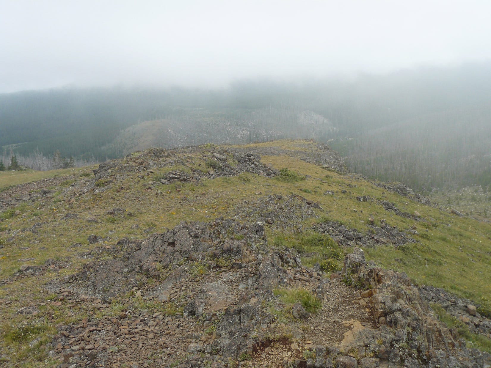
There was no trail, but Hesse Mountain is only about 1.25 miles SE of Munkres Pass as the crow flies.  Lupe and SPHP climbed through the forest.  Eventually Lupe reached tree line.  Fog was now swirling around the mountain.  At times Lupe and SPHP could see the summit or in other directions.  Visibility was good enough to guide Lupe to the top.  The area above tree line was dominated by boulder fields interspersed with some grassy areas which became increasingly scarce as Lupe gained elevation.

Lupe nearing the summit of Hesse Mountain.
Looking back towards the N high point (not the true summit) on Hesse Mountain.
Looking back towards the NE high point (not the true summit, but almost as high) on Hesse Mountain.
Near the summit of Hesse Mountain.

Lupe reached the summit of Hesse Mountain and found a cairn there.  On the other side of the mountain was a steep drop.  Soon fog moved in and completely shut off all views.

Reluctantly, SPHP decided this was it.  There was no sense in having Lupe try to go on to Hazelton Pyramid, which was seldom even in view with all the fog.  With no trails, if the fog moved in and stayed, it would be easy to get turned around and lost.  It didn’t seem that likely, but on the other hand, the Beartooths to the W where Lupe had just come from had been overcast and drippy for several days.  The weather in the Bighorns usually comes from that direction.

Success! Lupe at the Hesse Mountain summit 8-6-14.

Lupe seemed perfectly happy with her ascent of Hesse Mountain.  SPHP was happy with it, too.  At least Lupe had gotten to the summit of Hesse, even if Hazelton Pyramid had to be left for another day on another dingo vacation.  On the way back down, the fog continued to swirl around and come and go.  At times, the views were pretty good.  Five or ten minutes later, the clouds would close in again.  It felt kind of mystical.  Views came and went in unpredictable directions.

The lower NW high point on Hesse Mountain.
Rocks near Hesse Mountain summit.
Looking N towards Hwy 16 from Hesse Mountain.

Lupe reached the G6 again at 12:22 PM.  It was a pleasant 65°F, still overcast, calm and almost foggy.  Lupe and SPHP had lunch near the stone pillar at Munkres Pass before heading out.

SPHP hatched another peakbagging plan for Lupe.  Even though she was about to leave the Bighorn Mountains, she might still go up to Warren Peaks (6,650 ft.) or climb Inyan Kara (6,360 ft.) in the Black Hills of Wyoming on the way home.  It didn’t happen.  At a gas station convenience store in Buffalo, WY there was news on the TV about severe storms and flooding in the Black Hills.

Lupe and SPHP just cruised E on I-90 back to the Black Hills of South Dakota and home.  The 74th annual Black Hills Motorcycle Classic was going on in Sturgis, SD.  It was kind of fun to be packed in with huge numbers of motorcyclists flocking to the area.  There were still big clouds around, but the storms seemed to be over in the Black Hills by the time Lupe reached them.

Shortly before 6:00 PM, Lupe arrived home.  Her great summer of 2014 Dingo Vacation all the way to the Canadian Rockies and back was over.  Lupe had been gone 23 days, 22 nights and traveled 3,288 miles in the G6.  Dingoes are very practical.  They don’t dwell on the past or statistics much.  If Lupe was sad that it was all over, she didn’t show it.  As soon as she got home, Lupe happily ran next door to Dog Heaven to hit up the neighbors for a treat.

Hesse Mountain in the Bighorns was Lupe's last peakbagging success of her summer of 2014 Dingo Vacation.
Hesse Mountain in the Bighorns was Lupe’s last peakbagging success of her summer of 2014 Dingo Vacation.

Links:

                        Next Dingo Vacation                     Prior Adventure

                   This Dingo Vacation                              Prior Dingo Vacation

Want more Lupe adventures?  Choose from Lupe’s 2014 Canadian Rockies & Beartooths Adventure IndexDingo Vacations Adventure Index or Master Adventure Index.  Or subscribe free to new Lupe adventures.

High Park Lookout & Sheep Mountain, Bighorn Mountains, Wyoming (8-5-14)

SPHP woke up in the G6 about 7:30 AM on the morning of 8-4-14.  Lupe and SPHP were parked near their favorite camping spot on the Clark’s Fork of the Yellowstone River in the Beartooth Mountains.  The previous day Lupe and SPHP had spent a wonderful long day climbing Lonesome Mountain, the highest mountain Lupe has ever climbed so far.  The sky was overcast, but not too dark.  SPHP had hopes of pitching the tent next to the Clark’s Fork of the Yellowstone, and spending a lazy recovery day there with Lupe while plotting new adventures in the Beartooths.

It was not to be.  Although by 11:30 AM SPHP was able to claim Lupe’s favorite camping site, it started to rain.  The rain lasted for several hours and then quit.  The skies remained heavily overcast.  The tent didn’t get set up.  The mosquitoes were bad.  The skies never cleared.  Everything outside was sopping wet.  No ray of sun appeared.  Lupe and SPHP spent most of the day in the G6 resting up and waiting for the weather to break.  It looked like it could start raining again at any moment.  Another night was spent in the G6.

On 8-5-14, SPHP woke up at 6:45 AM.  52°F and still heavily overcast, almost foggy.  Lupe was well rested again by now.  There wasn’t going to be any keeping the lively dingo satisfied with another day in the G6.  SPHP’s plans for more Lupe adventures in the Beartooths had to be scrapped.  It was time to move on.  Lupe and SPHP headed for Cody, WY via the Chief Joseph Scenic Byway, Hwy 296 and then Hwy 120.  Lupe’s 2014 Dingo Vacation to the Canadian Rockies & Beartooth Mountains was rapidly drawing to a close.

It wasn’t over yet, though.  The fog and clouds were hanging over the mountains to the W, but Lupe and SPHP drove out into the sunshine even before reaching the pass on Hwy 296.  SPHP still had a few adventures in mind for Lupe.  After  fueling up in Cody, just to see something new Lupe and SPHP continued SE on Hwy 120 through Meeteetse all the way to Thermopolis.  Lupe was happy just to be moving again with the opportunity to bark at cows and horses along the way.  Neither SPHP nor Lupe had ever taken this route before, so it was all new and interesting.

Most of the way from Cody to Thermopolis was like much of Wyoming – sagebrush, dry high plains with ridges and buttes all around and higher mountains in the distance.  Very Old West looking and largely unspoiled.  Meeteetse is in the Greybull River valley where there were some green trees, green irrigated fields, and a little more going on.  Meeteetse itself is less than 400 population.  Thermopolis was considerably larger, around 3,000 population.  It is named after natural hot springs in the area.  After days spent outdoors, SPHP was pretty grimy.  SPHP was looking forward to the hot springs as a great relaxing way to get cleaned up.

Lupe at the Stegosaurus roaming the grounds at the Thermopolis hot springs.
Lupe roaming the grounds at the Thermopolis hot springs with a Stegosaurus.  American Dingoes are natural born leaders.

Fortunately the day hadn’t heated up much yet, with temperatures still around a comfortable 70°F.  SPHP left Lupe in the G6 parked in the shade with the windows partially down.  She set about entertaining herself by watching squirrels in the trees.  SPHP spent a pleasant hour and a half in the pools or on the waterslide at the State Bath House, and returned much revived to the by-now bored dingo in the G6.  Nothing promotes an appreciation of cleanliness like long days spent outdoors.

It was time to head for the Bighorn Mountains!  The drive on Hwy 16/20 from Thermopolis to Worland was flat and dull with little to commend it, but heading E from Worland to Ten Sleep on Hwy 16 was another matter.  The scenery was wild, remote and dramatic.  At Ten Sleep, SPHP noticed that Dirty Sally’s was still open, but didn’t stop.  E of Ten Sleep, Hwy 16 started up beautiful Ten Sleep canyon into the Bighorns.

A little over a mile past the lodge on Meadowlark Lake, SPHP turned S on FS road No. 429.  SPHP parked the G6 just off No. 429 close to the highway.  Lupe was certainly ready to get out and stretch her legs again.  No. 429 is a gravel road that leads about a mile up through mostly open meadows to a forest near High Park Lookout (9,477 ft.).  There is a small parking lot at the edge of the forest.  A 15 minute hiking trail winds up through the forest to the old lookout tower.  The now unmanned lookout tower is closed to the public due to a broken support beam.

Lupe along road No. 429 on her way to High Park Lookout in the Bighorn Mountains. No. 429 is accessed via Hwy 16 a little over a mile SE of Meadowlark Lake.

Lupe and SPHP followed No. 429 and then the hiking trail to the High Park Lookout summit.  From some rocks near the lookout tower the best views were toward Meadowlark Lake to the NW and the higher mountains to the NNE.  On the way back down to the G6, Lupe followed the trail to the little parking lot, but did not follow No. 429 again.

Instead, Lupe and SPHP took a shortcut through the beautiful high country meadows and a small forest.  That got Lupe more into the spirit of things than just following the road.  She started sniffing and exploring around more enthusiastically.

Lupe at the High Park Lookout in the Bighorn Mountains. Photo looks N.
At look back up at High Park Lookout. Lupe was already on her way back to the G6. Photo looks S.

From High Park Lookout, Lupe and SPHP had seen lots of clouds around.  To the N where the Cloud Peak Wilderness is, all the high country was lost in dark clouds and fog.  Any thoughts SPHP had of taking Lupe to Cloud Peak were dashed.

There were fewer clouds to the S though, and SPHP started thinking about climbing Hazelton Pyramid as a substitute.  Consulting the maps, SPHP found it might be possible to hike three 10,000+ foot peaks easily enough in a day – Hesse Mountain (10,382 ft.), Hazelton Pyramid (10,534 ft.), and Hazelton Peak (10,264 ft.).  SPHP decided Lupe would try it the next day.

Lupe and SPHP headed E on Hwy 16 over Powder River Pass.  About a mile E of Powder River Pass, SPHP turned S on gravel road No. 29 and about 1/8 mile later onto USFS Road No. 448.  Half a mile later Lupe arrived at Munkres Pass.  Hesse Mountain and Hazelton Pyramid had been visible from No. 29 and looked like easy climbs.  SPHP was satisfied that Munkres Pass was a good starting point for Hesse Mountain the next day.

Lupe and SPHP left Munkres Pass to find water and a place to park for the night.  Water was found at Lost Cabin campground, and SPHP was fortunate to find a dispersed camping spot along gravel road No. 28 just after it crossed Merle Creek.

The G6 at the dispersed camping site on Merle Creek.

Lupe was quite happy with Merle Creek, a rushing little stream where she was able to drink and lay down to get cooled off.  She soon found squirrels to bark at in the surrounding forest, always a major dingo benefit.  SPHP checked the map and saw that only another 1.5 miles from Merle Creek, road No. 28 ended at the Sheep Mountain (9,610 ft.) lookout tower.  Leaving the G6 at Merle Creek to claim the spot, Lupe and SPHP set out along No. 28 to go see the views from Sheep Mountain.

The lookout tower at the top of Sheep Mountain.

There wasn’t much to see.  By the time Lupe and SPHP reached the top of Sheep Mountain, there was fog in every direction.  Dark clouds and thunder were to the E, but were moving farther away out onto the prairie beyond the Bighorns.   No one else was around.  Lupe and SPHP got up on the platform around the top of the lookout tower.  SPHP took a few photos.

The area immediately around the tower was not yet in the fog, but it was close by on all sides.  Less than 10 minutes after Lupe left, the Sheep Mountain Lookout Tower itself disappeared in the fog.  On the way back, instead of following the road, Lupe and SPHP headed down the SW slope of Sheep Mountain going almost directly back to the G6 through a big opening in the forest.

A happy American Dingo arrives at the Sheep Mountain lookout tower to see what there is to see.
Normally the views would be great from Sheep Mountain. When Lupe was there, not so much.
Lupe on the Sheep Mountain lookout tower.
Look, SPHP!  The view is almost as good with my eyes closed!

Despite the fog, the trek up Sheep Mountain had still been a pleasant excursion.  Once back at the G6, Lupe had some Alpo and entertained herself barking at squirrels.  Dusk came on.  The squirrels called it a day and disappeared.  Without the squirrels around, Lupe realized she was kind of tired too.  She wanted to get in the G6.  There she curled up for the night on her throne of blankets and pillows.  SPHP stayed up sitting on a big stone next to Merle Creek until it was too dark to write.

Lupe in Merle Creek, Bighorn Mountains of Wyoming, 8-5-14

Links:

Next Adventure                       Prior Adventure

Peak 9300 & High Park Lookout, Bighorn Mountains, Wyoming (6-30-19)

Want more Lupe adventures?  Choose from Lupe’s 2014 Canadian Rockies & Beartooths Adventure IndexDingo Vacations Adventure Index or Master Adventure Index.  Or subscribe free to new Lupe adventures.

Lonesome Mountain in the Beartooth Mountains of Montana (8-3-14)

The highest peak Lupe has ever climbed to date is Lonesome Mountain (11,399 ft.) in the Absaroka-Beartooth Mountains.  Lupe and SPHP first saw Lonesome Mountain on a day hike with Lanis on Lupe’s first ever big Dingo Vacation in the summer of 2012.  Lupe and SPHP returned to the area for two more treks, one to Two Bits Lake and another to Sky Pilot Lake during Lupe’s 2013 summer Dingo Vacation.  There are other higher ridges and peaks around, but Lonesome Mountain stands separate and alone in all its glory.  SPHP always thought it looked potentially climbable from the S by an adventurous little Carolina Dog.

This long day hike starts at the Island Lake Trailhead near the Island Lake campground on the N side of the Beartooth Highway No. 212 in NW Wyoming.  The Island Lake campground is approximately 2 miles E of the Top of the World Store & Motel or roughly 15 miles E of Hwy 212’s junction with the Chief Joseph Scenic Byway, Hwy 296.  The hike starts at Island Lake (elevation 9,518 ft.) and gains less than 500 ft. all the way to Albino Lake (elevation 10,000 ft.) at the foot of Lonesome Mountain.  Then the real work begins.

Lupe and SPHP left the Little Belt mountains of Montana on the morning of August 2, 2014, after climbing King’s Hill.  The plan was to head for the Beartooth Mountains in NW Wyoming and southern Montana.  Lupe took Hwy 89 down to White Sulphur Springs and eventually all the way S to I-90.  This was a very pretty scenic drive through big rounded mountains of the Little Belt range, soon followed by high rolling prairie and wide river valleys.  It all looked very Old West and mostly still unspoiled.

SPHP stopped at a city park along the N bank of the Yellowstone River after getting food and gas in Columbus, MT.  Lupe drank out of the Yellowstone River and cooled off in it.  She also managed to find something very stinky to roll in to hide her scent.  SPHP objected to her proudly worn new scent.  Lupe had to get back in the river again to wash it off.  From Columbus, Lupe took Hwy 78 to Red Lodge, MT and then Hwy 212 up and over fabulous Beartooth Pass (elevation 10,947′).

Lupe and SPHP arrived at their favorite camping spot on the Clark’s Fork of the Yellowstone River by mid-afternoon, but the site SPHP wanted wasn’t available.  Lupe and SPHP hung around enjoying the beauty of the location while waiting to see if the site would open up.  After a few hours, it did!  SPHP ran for the G6, turned the key – and nothing happened.  The battery was dead!  It started to rain.  The windows were open and couldn’t be closed.  An error message on the G6 said “Service Traction”.  This helpful message went unmentioned in the owner’s manual.

Eventually two people appeared and were kind enough to give the G6 a jump.  Lupe and SPHP headed for Cody, WY over the Chief Joseph Scenic Byway in rain, lightning, thunder and hail.  A double rainbow cheerily appeared on the E side of the pass.  It was late on Saturday evening when Lupe reached Cody.  SPHP found a Wal-Mart.  Wal-Mart was a great place to be since it had almost anything Lupe or SPHP might desire, was open all night, and a new battery for the G6 could be had there in the morning.  After getting a sandwich at the Subway in Wal-Mart (plus 3 free cookies they were about to throw away because it was closing time), SPHP tried the G6.  It fired right up!  Maybe the battery wasn’t really bad.

The night was spent in the G6 in the Wal-Mart parking lot.  SPHP dreamed wild and vivid dreams, but Lupe slept soundly.  Or maybe she always has wild and vivid dreams.  Sometimes she twitches.  It was already very late, after 8 AM, by the time SPHP regained consciousness on Sunday morning.  The G6 started right up again!  Nevertheless, SPHP talked to a gentleman in the Wal-Mart automotive center.  They couldn’t diagnose or fix complicated problems, but they could install a new battery.  The gentleman suggested waiting until Monday to take the G6 to a repair shop.

SPHP had a better idea.  Why not drive all the way back to the Beartooths and make the most of the day?  The secret was to park the G6 so it would be easy to get another jump if the battery pooped out again.  Lupe was going to climb Lonesome Mountain!  It was 10:13 AM, clear, calm and a perfect 61°F when Lupe and SPHP left the quirky G6 at the Island Lake trailhead in the Beartooths.  The mosquitoes were bad and SPHP was slathered with unhealthy DEET.

Lots of people were around on the trail, which headed N on the W side of Island Lake.  A guy from Michigan said it was supposed to rain at 3 PM.  This was concerning.  There were already some clouds on the western horizon.  One lady reported having seen a grizzly bear and two cubs just 10 minutes before Lupe and SPHP came along.  Lupe wasn’t even past Island Lake yet.  The fishermen SPHP talked to were all having good success catching fish – mostly cutthroat trout.

Lonesome Mountain from near Becker Lake.
Lonesome Mountain from near Becker Lake.  Lupe climbed up near the left side.

The trail passed through gorgeous territory.  This may be the best hike Lupe and SPHP have ever been on outside of the Canadian Rockies.  There were beautiful wildflowers everywhere.  The mountain scenery was impressive.  Lupe and SPHP passed a succession of splendid alpine lakes – Island Lake, Night Lake, Flake Lake, Mutt & Jeff Lakes, and Becker Lake.  There was only one trail intersection to watch for, which was a right turn 2.5 miles from the start (at the S end of Island Lake) onto the trail that goes between Mutt & Jeff Lakes.  The only bad thing was the mosquitoes.  Lupe really couldn’t stop anywhere for more than a few minutes before they came swarming in.

N of Becker Lake, Lupe and SPHP left Wyoming and entered Montana.  There was no sign.  At the S end of Albino Lake at 10,000 feet it was time to leave the trail.  Lonesome Mountain loomed high above Albino Lake just to the W.  Lupe and SPHP turned SW and headed for the big ridge that projects SSE from Lonesome Mountain.  Once up on the ridge, Lupe discovered lots of hidden ponds and deep snow banks.  Lupe and SPHP turned NNW and headed for the summit of Lonesome Mountain scrambling up and down over big granite ridges.

Albino Lake from the SW near where Lupe left the trail. This shot was actually taken in the evening when Lupe returned to the trail.
Eventually the climb turned into just a scramble over huge boulder fields all the rest of the way to the top of Lonesome Mountain.  Lupe is an excellent scrambler and could have been at the top of the mountain long before SPHP got there.  The weather started deteriorating all around as Lupe and SPHP scrambled ever higher on the mountain.  SPHP’s progress over the big boulders was painfully slow.  Lupe was always appearing nearby looking like a true explorer surveying the world from the heights of various boulders.

As SPHP finally got close to the top of Lonesome Mountain, the rumble of thunder could be heard in the distance.  A big rainstorm was in progress some miles to the S.  Fortunately, SPHP did not see any cloud to ground lightning.  Lupe and SPHP finally reached the top of Lonesome Mountain.  The view was spectacular.  Lupe and SPHP could see lots of lakes and mountains that SPHP hadn’t ever seen before except on maps.

Lupe on Lonesome Mountain 8-3-14
Looking S from Lonesome Mountain. Island Lake is the most distant larger lake toward the center. Part of Becker Lake is seen much closer on the left. Beauty Lake is on the right.
Looking S from Lonesome Mountain. Island Lake is the largest distant lake toward the center.  Night Sky Lake is right next to Island Lake but closer and smaller.  Part of Becker Lake is seen much closer on the left. Beauty Lake is the largest and most distant lake on the right.
Beartooth Butte from Lonesome Mountain. The long skinny lake is Lonesome Lake.
The view to the NNE of Lonesome Mountain. A portion of Jasper Lake is seen at the lower left.

A woman on the trail between Albino and Becker Lakes had told SPHP she tried to climb Lonesome Mountain earlier this day, but ran out of time.  She told SPHP that the summit in view was a false summit.  Lupe and SPHP had climbed the false summit.  Quite a distance to the NW, SPHP could see another summit separated from where Lupe was by a big drop-off and then a saddle consisting of another boulder field.  It all looked very possible to get over to the true summit easily enough, but it was late in the day already and would have taken at least an hour to get over there.

The NW high point of Lonesome Mountain is seen in the distance and may be nominally higher than the high point Lupe climbed.

In a way it really didn’t matter – the true summit looked to be at essentially the same elevation as the false summit.  A check of SPHP’s maps showed both summits within the same elevation contours.  The difference in height between the two summits can only be a matter of 0-20 feet.  (Later on SPHP found out that on Peakbagger.com the false summit at 10,399′ which Lupe did climb is listed as the high point on the mountain, although a 10,400′ contour is shown to the NW.  SPHP’s Alpine Quadrangle of the Absaroka-Beartooth mountains shows a height of 10,409′ to the NW.)

Lupe on Lonesome Mountain 8-3-14

Lupe and SPHP would have loved to stay up on the summit (false or not) of Lonesome Mountain to enjoy the views while figuring out which lake below was which.  However, although current conditions were just cool with a light breeze, Lonesome Mountain was now surrounded by threatening weather.

To the S there was a big storm going on.  Dark clouds hung just over the huge ridge to the NE.  Back at Island Lake where Lupe had come from, SPHP could see it was raining hard.  Off to the W an ominous line of dark clouds and showers was approaching.  A cloudburst was going on to the SW.  SPHP was pretty certain rain was going to hit within 30 minutes.  Rain wouldn’t be too bothersome, and even hail might be avoidable under the shelter of a big boulder, but lightning would be potentially deadly.

Looking NW toward the possible true summit of Lonesome Mountain. Some maps indicate it might be 10,409 feet, whereas the summit Lupe climbed may be only 10,399 feet. Close enough for Dingo play!
Looking NW toward the possible true summit of Lonesome Mountain. Some maps indicate it might be 10,409 feet, whereas the summit Lupe climbed may be only 10,399 feet. Close enough for Dingo play, especially with stormy weather around!

SPHP snapped  a few quick photos and told Lupe it was time to get down off Lonesome Mountain ASAP.  So began the scramble down.  It took quite a long time, but not as long as going up.  SPHP thought about going down by Lonesome Lake, which could be seen clearly to the SW.  Lupe and SPHP have never been there before.  That whole area looked full of lakes easy to reach.  It would have been fun to explore there, but a look at the map showed it would be a longer hike back to the G6.  SPHP knew Lupe was going to be late enough getting back to the G6 as it was.

About 20 minutes after Lupe started down, it did start to rain, but it never rained hard.  Lupe and SPHP only got sprinkled on, and even that only lasted maybe 20 minutes.  Eventually the skies to the W cleared.  The storm to the S still rumbled.  There was some cloud to ground lightning, but it was far away.  It became apparent Lupe and SPHP were not going to get caught in any significant storm.

It took Lupe and SPHP a long time to work their way back down to Albino Lake.  The were-puppy liked to attack SPHP on the big snow banks that had to be traversed, but SPHP was now in too much of a hurry to play the were-puppy game.  On one snow bank SPHP suddenly noticed a dark pink, almost red color on Lupe’s white vest and paws.

Lupe wanted to play the were-puppy game on the snow banks on Lonesome Mountain.

Initially SPHP thought maybe Lupe was injured and bleeding from some mishap in the boulder fields, but upon examination it proved to be just some of the pink coloration that is common on the old snow banks here.  Lupe certainly acted like she felt not only fine, but terrific!  Once down out of all the super rocky stuff up on the ridge, Lupe took off running great distances at top speed racing here and there over the heather.  She had an absolutely wonderful time.

Nope, not blood. Just pink stuff from the snow on the puppy.

Lupe and SPHP rejoined the trail at Albino Lake.  They went long distances on the trail without seeing anyone.  The last sunlight to shine on Lupe was at Becker Lake.  Other day hikers had already returned to the trailhead.  Backpackers had already reached their camping destinations.  Lupe and SPHP met just a very few people, but otherwise the trail was empty.  It grew so dark it was hard to see the trail, but SPHP didn’t use the flashlight until the final major stream crossing at the outlet from Island Lake.  The campground was totally dark and quiet.

Lupe arrived at the G6 at 10:09 PM.  It was 44 degrees F.  SPHP fed Lupe some Taste of the Wild and Alpo.  She was tired.  SPHP was tired too.  Thankfully, the G6 started up.  SPHP drove in the darkness back to Lupe’s favorite spot on the Clark’s Fork of the Yellowstone River for another night in the G6.  At nearly 12 hours, this hike proved to be Lupe’s last really long day hike of her 2014 Dingo Vacation to the Canadian Rockies & Beartooth Mountains.  Climbing Lonesome Mountain had been a wonderful time.  Lupe agreed it sure beat spending the day cooped up in the G6 in the Wal-Mart parking lot!

Beartooth Butte from Lonesome Mountain 8-3-14
Beartooth Butte (10,514 ft.) from Lonesome Mountain 8-3-14

Links:

Next Adventure                      Prior Adventure

Want more Lupe adventures?  Choose from Lupe’s 2014 Canadian Rockies & Beartooths Adventure IndexDingo Vacations Adventure Index or Master Adventure Index.  Or subscribe free to new Lupe adventures.