Day 2 of Lupe’s 2017 Dingo Vacation to the Laramie Range, Wyoming & Beyond!
Lupe shot out into the night. No telling what hour it was. No doubt it was late, very late. Following a road to the top of Black Mountain (7,960 ft.) yesterday hadn’t been hard enough to wear the Carolina Dog out. She was all stirred up about being on a Dingo Vacation again, and had been staring out of the G6 watching the dark forest for hours. SPHP wasn’t all that sleepy, either. May as well join Looper out there.
The night air was pleasantly cool. Only a few stars could be seen through high, thin clouds. The nearly full moon was so bright, no other light was necessary. SPHP strolled S along USFS Road No. 633, while Lupe explored small fields nearby. The flowing waters of Horseshoe Creek and Lupe’s sniffing made the only sounds breaking the silence.
Forty minutes later, Lupe was back at the G6. She helped devour the rest of the leftover roasted chicken, then was finally able to fall asleep. By the time SPHP woke up again, the sun was shining. A surprisingly strong, cool breeze was blowing down the Horseshoe Creek valley. Lupe and SPHP spent a little time down by the stream. The sky clouded up.

The wind was strong enough so making breakfast was going to be a bother. SPHP decided to skip it. The roasted chicken in the night could serve as breakfast. Lupe was raring to go, anyway. Onward!
SPHP drove toward Lupe’s next peakbagging destination, following USFS Road No. 633 back to Esterbrook. From there Lupe enjoyed a scenic ride SW on Country Road No. 5. A huge herd of beautiful cows appeared ahead right on the road! Another cattle drive, or perhaps it was the same one Lupe had passed yesterday back at Prairie Dog Hill (6,400 ft.), was going on. In any case, another enthusiastic barkfest was in order.
Once safely a few miles beyond the cattle, SPHP stopped the G6 near a big rock outcropping providing a great view of Lupe’s next challenge. Eagle Peak (9,167 ft.) loomed to the S.


By 10:23 AM (67°F), the G6 was parked only a mile NW of Eagle Peak near the 3-way intersection of County Roads No. 5 & 71, and USFS Road No. 671. Lupe started out on No. 671, but quickly left it to follow a steep side road up an open slope. When the side road turned NE to rejoin No. 671, Lupe left it as well, climbing SE up into the forest.
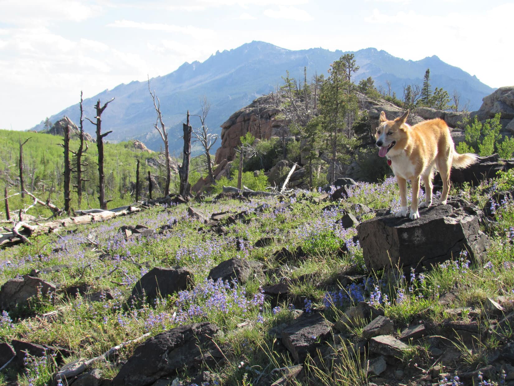
The forest was full of cheerful yellow flowers.

The climb through the forest was fairly steep. Lupe soon reached a high point where she could not advance any farther toward Eagle Peak. Gah! She was going to have to lose some of her newly gained elevation. From high rocks, a flowery open saddle could be seen below to the SE.
Lupe ultimately lost 100+ feet of elevation working her way NE through thick forest and boulders before she came to a point where she could reach the open ground safely. She then had to head S back up to the flowery saddle. Not very efficient.

Great job of route finding, SPHP!
Pshaw! A minor setback. Puppy, ho! Onward!
From the flowery saddle, Lupe went SSW, skirting around the W side of another minor high point. She then turned SE, and quickly arrived at the edge of a small valley. A thickly forested hillside rose from the valley, climbing steeply toward the rocky upper NW face of Eagle Peak.
It looked like it might be possible to simply climb the NW face straight to the top of the mountain. Then again, maybe not. The rocky summit ridge was a long way up, still too far off to see details well. The topo map seemed to indicate it might be easier to approach the mountain from the SW.
High up on the mountain toward the S, an area of burnt forest was visible. Maybe Lupe should head toward that?

SPHP led Lupe across the small valley, entering the forest. Loop traveled SSE gaining elevation steadily. The immediate goal now was to reach the burnt forest high up on Eagle Peak’s SW slope. The Carolina Dog had a good time exploring the living forest, which went on for quite a long way. She stopped for water and to relax a few times when SPHP needed a break.


The living forest was nice and cool, but the morning’s clouds had mostly dissipated by the time Lupe reached the start of the burnt area. The day was sunny, bright, and getting warmer. Lupe could now see more of the territory higher up. The view improved as Lupe continued climbing. The top of the mountain was still hundreds of feet higher.

At first the burnt area was quite easy to navigate through, but as Lupe got higher up, she started encountering more deadfall, larger boulders, and some living trees as well that made progress increasingly difficult. Lupe and SPHP turned ESE to climb more aggressively, but the terrain grew worse. Finally, it became clear that the Carolina Dog was rapidly approaching the base of a nearly vertical wall of solid rock.
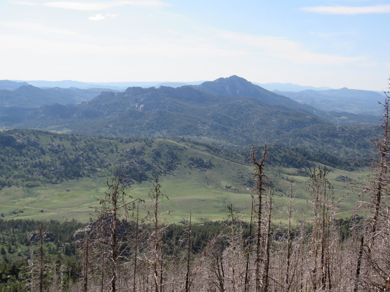
By now, Lupe wasn’t too far from the S end of the mountain. SPHP had her head that way, looking for a break in the rock wall that would let her get up on top. No dice. The vertical rock wall was continuous. Lupe finally reached the S end of it. She was now quite high on Eagle Peak, and had a good view of the 2 mile long ridge far below leading SSW to Jack Squirrel Peak (8,942 ft.).
SPHP had hoped Loop would be able to follow that SSW ridge to climb Jack Squirrel Peak after summiting Eagle Peak, but that clearly wasn’t in the cards. The ridge was way too rough. Nearly all of it had burned, and there would be a ton of deadfall down there, too. No way would there be time enough to navigate through all that!

Of course, there wasn’t much use in worrying about Jack Squirrel Peak yet, anyway. Lupe still hadn’t found a way to the top of Eagle Peak. A quick check of the topo map suggested that maybe she could go around the S end of the vertical rock wall and find a way up along the E side?
The rock wall was only a few feet thick at the S end. Lupe could now see spruce trees growing in a corridor to the E. The initial view was encouraging. May as well try it!

Lupe and SPHP circled around the S end of the vertical rock wall over to the E side. It was slow going amidst large boulders, and a mix of living trees and deadfall. However, Lupe and SPHP both made it, and found there was indeed a channel of forested land rising steadily to the N on the E side.
For a short distance, Lupe stayed right along the E base of the vertical rock wall as she climbed N. However, the wall rose higher to the N, too. Lupe wasn’t making any apparent progress toward being able to get up onto it.
The terrain immediately below the wall became increasingly difficult. Tightly packed spruce trees and boulders forced Lupe E away from the wall in order to make any progress at all. Even over here, the going was far from easy. Lupe was often down in cave-like spaces between boulders, while SPHP worked up and around them. Once SPHP was up, the crafty American Dingo always found a way to bound higher, too.
As Lupe climbed, she reached the W side of another, somewhat smaller rock wall along the E side of the corridor leading higher. After following this wall N up a short distance, several breaks appeared revealing large cliffs only a few feet away, and big views to the SE. SPHP was glad when those gaps ended a little higher up, and the unnerving cliff views were walled off again.

Lupe kept climbing N, but the rock wall to the W continued to get higher, too. If only she could scramble 30 or 40 feet up the wall, she would be on top, but there didn’t seem to be a way to do it. Finally, SPHP spotted a route that might work. If Lupe could reach a small green tree a little more than halfway up, the rest should be easy. It looked feasible.

By the time SPHP spotted this possible route via the small green tree, Lupe was nearing a pass only a little farther N. Maybe a more certain and easier way up would be visible N of the pass? Should probably check that out first! Hopes soared as Lupe approached the pass.
The view N from the pass was a colossal disappointment. All that could be seen was a line of enormous cliffs extending along the entire E side of the mountain. The continuous rock wall to the W offered not the slightest encouragement. Forget that!

The American Dingo retreated S from the pass back down to the potential route via the little green tree. It was Lupe’s last hope of reaching the summit from anywhere along this SE side of the mountain.
Lupe and SPHP went closer to investigate. The truth was plain within only a few minutes. No, there wasn’t any way Looper could get to that little green tree. It was all an illusion. The whole foray around the SE side of the mountain had been a huge waste of time and energy.

No hope remained over here. Lupe had to return to the W side of the mountain. Slowly, slowly, Loop and SPHP worked S back down the channel E of the vertical rock wall. Time ticked by. Lupe and SPHP made it back to the S end of the mountain, and around to the W side.
The plan once again was to stay near the base of the vertical rock wall, and follow it N until a way up could be found. SPHP was still optimistic Lupe would succeed over here, if she went far enough N.

Looper seemed happy and optimistic, too, but the slog N was painfully slow going. This high up, there were plenty of obstacles on the W side of the mountain, too. More giant boulders, more deadfall, more live trees.
On and on, yet no matter how high Lupe got, the top of the vertical rock wall was always out of reach. Sometimes not terribly far out of reach, only 40 or 50 feet in some places, but out of reach nevertheless. Frustration began setting in. Wasn’t there any way up?
As if it was needed, a new worry appeared. Off to the N was another long section of Eagle Peak’s summit ridge. It was separated by a saddle from the S end of the mountain where Lupe had been trying to get up. SPHP had tried to lead Lupe up the S end, partly because that was where the topo map showed the 9,167 ft. survey benchmark. However, another look at the map showed that both the N and S ends of the mountain had sizable areas enclosed by the 9,160 ft. contour.
Maybe the true summit of Eagle Peak was actually over at the N section of the summit ridge, instead of at or near the S section’s survey benchmark? Entirely possible. Lupe’s first view from this high up over at the N section revealed 3 vertical prongs of rock grouped close together. They looked high. Maybe higher than anything over here?


Fine, fine, Loop, just peachy fine! Have your little laugh, or big one if you like, but here’s the deal. If we can get to the top of either the S section or the N section of the summit ridge, we are going to call it good enough for Dingo work. You can then claim a peakbagging success on Eagle Peak and we can get out of here. Unless, of course, it’s completely clear from up on top that the true summit is definitely at the other section? What do you think?
OK, but I really think there’s no need to keep consulting your silly, misleading, inconclusive maps. Maybe it’s time to consult a psychiatrist, instead! You might get to the bottom of all this, if not the top.
Ha, ha! So hilarious! Come on, let’s get on with it. Either way, success or defeat, I’m about done with Eagle Peak.
Oh, maybe you still do have a marble or two left!
Lupe came close to making it. Twice she got within 20 feet or so of reaching the top of the vertical rock wall. One route looked possible, but too exposed. SPHP wouldn’t chance it. The other appeared effectively blocked by a single boulder.

If she could have gotten up on that wall, SPHP believed Lupe would have had an easy stroll with only minor additional elevation gain required to reach Eagle Peak’s summit. It never happened. All hope of reaching the top of the mountain’s S section of the summit ridge disappeared when the N end of it ended in big cliffs.
Attention shifted to trying to get to the top of the N section of the ridge. Unfortunately, the clearer view of it that Lupe had now was even more daunting than before.
Lupe would be approaching the 3 vertical prongs from the S where the steep rock offered little encouragement. Worse yet, what could be seen of the top of the ridge farther N looked like a narrow string of rock knobs difficult and dangerous to traverse, even if it was possible to get up there somehow. Towering cliffs were seen to the E, and it looked like there must be cliffs of lesser, unknown height to the W.
Nevertheless, staying toward the W, Lupe and SPHP headed down to the saddle leading to the N section of the summit ridge. Lupe crossed the saddle and succeeded in regaining some elevation, but as expected, there was no way to the top from here.

It was still entirely possible Lupe might be able to reach the top of the N section of the summit ridge from the NW. She had seen that much earlier in the day. From here, though, even trying it would mean a big down climb, and then another search for a route up working N along the W side of the long ridgeline. No way. Not today. SPHP was done.
Let’s get some photos from here Loop, and call it good.
Lupe barked happily! She was ready to call it a day, too.


On the way back down, Lupe passed through the burnt forest again.

SPHP made the mistake of leading Lupe N too soon. She should have lost more elevation first. This way the burnt forest went on and on. Maybe it was just the sense of defeat, but what should have been a relatively easy trek back, seemed much longer and steeper than the way up had been. When Lupe finally reached the live forest, it also seemed to go on forever. The American Dingo turned W, plunging relentlessly down the mountain. SPHP became afraid she was going to cliff out, but she didn’t.
Somewhere near the end, Lupe’s routes up and down crossed. At last, the Carolina Dog emerged from the forest, reaching relatively level open ground near County Road No. 710. The NW slope of Eagle Peak didn’t look all that daunting from down here.

Oh, well! What was done was done. Que sera. It was over. Next time Lupe would just go straight on up that NW slope! If there ever was a next time. Defeat bred pessimism.
Lupe reached the G6 again at 6:52 PM (72°F). Denied, after 8.5 hours on a mountain only a mile away, with less than 1,500 feet of elevation gain required to summit! How was that even possible? SPHP felt sunburnt, battered, bruised, scraped, and worn out. The plucky American Dingo looked fine, but you could bet even she wouldn’t be taking any long moonlit strolls tonight!
SPHP drove around the N end of Eagle Peak heading E on USFS Road No. 671. Lupe would spend the evening at a dispersed camping site off USFS Road No. 681 leading to Friend Park near Laramie Peak.
What a gorgeous evening! On the way to No. 681, SPHP stopped briefly NE of the mountain to let Lupe out for another look. Eagle Peak stood high and wonderful, its crown surrounded by an intriguing variety of cliffs and spires. Lupe had nearly reached the top. Almost, but not quite. The lofty summit remained the domain of eagles, not dingoes.
Sometimes that’s the way it goes.

Links:
Next Adventure Prior Adventure
Jack Squirrel Peak, Laramie Range, Wyoming (6-19-17)
Want more Lupe adventures? Choose from Lupe’s 2017 Laramie Range, Wyoming & Beyond Adventure Index, Dingo Vacations Adventure Index or Master Adventure Index. Or subscribe free to new Lupe adventures.