
Day 27 of Lupe’s 2017 Dingo Vacation to the Yukon & Alaska!
7:00 AM – Lupe prowled among the bushes sniffing excitedly. She liked this place! Getting to be late August. The bushes were starting to show some fall colors. SPHP stretched and walked around a bit looking at the views to the N or NE where mountains and glaciers of the Alaska Range could be seen 15 miles away beyond Monahan Flat.


The views were awesome, but the sky was more darkly overcast than SPHP would have liked. Lupe had an adventure planned for today over in Denali State Park. She intended to take the to Ermine Hill trail to a point where she could scramble up Ermine Hill (2,700 ft.), then press on taking the K’esugi Ridge trail to Golog Benchmark (2,970 ft.). A long day, but a fun one, if the weather didn’t interfere.
With so much in the works, Lupe had to get going. 47 miles of gravel road on Denali Highway No. 8 brought her to the pavement on George Parks Highway No. 3 at Cantwell. SPHP turned L heading SW for Denali State Park. Disappointingly, though no surprise, only the lower peaks of the Alaska Range were in view as Lupe neared Denali State Park. All the high stuff, including Denali (20,310 ft.) itself, was shrouded in clouds.
No other vehicles were at the Ermine Hill trailhead at milepost 156.5 when Lupe and SPHP arrived. Despite the general cloud cover, a few patches of blue sky offered encouragement. Looper was at least going to try for Ermine Hill. Whether she would continue all the way to Golog Benchmark might depend on how the weather developed.
A short stroll into the forest led to a registration station. SPHP registered, and the Carolina Dog was on her way. (9:59 AM, 51°F)

The Ermine Hill trail started off in a forest full of ferns. Lupe quickly reached a section of trail overgrown with tall grass, ferns, and bushes. It must have rained recently. All the vegetation was sopping wet. Within 5 minutes, Lupe and SPHP were, too.

The trail gained a little elevation going up a small hill, leveled out for a short distance, then turned SW and dropped close to 200 feet down into the Byers Creek valley. A footbridge across Byers Creek tilted somewhat precariously. The creek had undermined the foundation on the near bank. Fortunately the bridge was still stable enough to cross.

Beyond the bridge, the Ermine Hill trail paralleled Byers Creek through another area of thick, wet vegetation. The trail became quite muddy and went over a couple of similar, but much shorter and better supported footbridges. Lupe passed a scenic pond. The trail then started to climb. A final bridge crossed over a different rushing stream.

Once Lupe was over the last bridge, the trail began to climb in earnest. It wound up the W side of a steep slope in a series of long switchbacks. By the time the switchbacks ended, Loop was getting close to tree line. Here the trail straightened out, and proceeded SE up a long slope. Lupe left the forest behind, entering a zone of tall bushes. Soon she was above the bushes, too. She could now see lower peaks of the Alaska range to the N beyond the broad Chulitna River valley.

Lupe kept going up the slope, which eventually became more gradual. The trail was heading into a sheltered valley where a few scattered trees grew among another profusion of tall bushes.

The trail map showed the Ermine Hill trail would continue SE past a narrow lake tucked near the upper end of the valley. A little beyond the lake would be an intersection with the K’esugi Ridge trail. Lupe would eventually need to go there in order to continue on to Golog Benchmark. However, since the Ermine Hill trail only skirts the NE side of Ermine Hill and doesn’t go to the top, the Carolina Dog would first need to leave the trail to finish her ascent.
Lupe drew even with a small pond to the NE. She could already see the start of the narrow lake ahead. A steep, bush-free slope appeared next to the trail offering an unobstructed lane of tundra extending up to more open ground above. This looked like a fairly easy route, so Loop and SPHP left the Ermine Hill trail and started climbing.
The route was even easier than anticipated. The slope was plenty steep enough, but there wasn’t much huffing and puffing going on. Blueberry bushes only 4 or 5 inches high were everywhere! They were loaded with sweet, ripe blueberries. So addictively delicious! SPHP spent less and less time climbing, and more and more time consuming. Progress slowed to a few steps at a time.
The open tundra was beautifully colored. Lupe had lovely views to look at. Yet she became so bored waiting for SPHP, that she took to resting on the soft tundra. Each time SPHP finally managed to go a little farther, she would test the comfort of another slightly higher spot.


As SPHP consumed blueberries, blueberries consumed time. An hour went by before SPHP managed to gain 300 or 400 feet of elevation. Here, Lupe was on gentler, interesting terrain. Close by was a striking ridge of white sand and gray rock. It couldn’t be much more than another 100 feet higher, and looked like a cinch to climb.

No longer distracted by blueberries, SPHP accompanied Lupe heading W for the near end of the ridge. An easy climb brought Lupe to the top of the ridgeline for a look around.
The American Dingo saw several colorful rounded hills to the SE. Those rounded hills were all part of Ermine Hill, which encompasses a large area. In fact, the topo map shows 4 different areas contained within 2700 foot contours on Ermine Hill. SPHP anticipated Lupe might have to visit several, perhaps even all of them, to figure out which was the true summit. As it turned out, Lupe wasn’t going to have to work that hard.

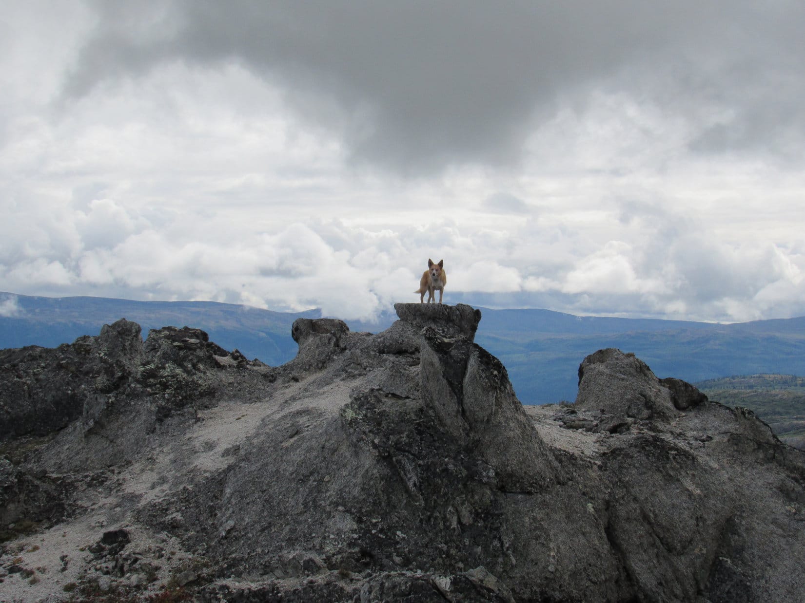
The colorful rounded hills Lupe saw to the SE included 3 of the 4 areas contained within 2,700 foot contours on the topo map. Lupe was clearly about as high as any of them. The 4th area was farther W on the ridge she was already on. The ground was noticeably higher over there. So it was easy to see that the true summit of Ermine Hill (2,700+ ft.) had to be closer to the W end of this ridge.
Looper didn’t have far to go to get there. She enjoyed a gorgeous, fun, easy ridge walk among flat sandy or gravelly areas and interesting rock formations. The very top of Ermine Hill featured an unusual summit offering a variety of convenient rocky Dingo perches. Despite the clouds, the views were tremendous in all directions.


Lupe could see Golog Benchmark (2,970 ft.) off to the SW. She had been there a year ago, having first reached K’esugi Ridge and Whimbrel Hill (2,645 ft.) from the Byers Lake trailhead. Today’s original plan called for Loop to continue on to Golog Benchmark from Ermine Hill. If she did so, she would complete the entire portion of the K’esugi Ridge trail system between the Byers Lake and Ermine Hill trailheads.
However, Lupe hadn’t gotten off to a very early start, the blueberry trap was another hour lost, and the weather didn’t look all that favorable. Rain showers were drifting up the Chulitna River valley only a few miles to the NW. Furthermore, Loopster would have to first lose 1,200 feet of elevation, then gain 1,500 feet to get over to Golog Benchmark, only to repeat a portion of that process just to get back to the Ermine Hill trail. Golog looked far away.

Loopster was perfectly content lingering up on Ermine Hill, while SPHP pondered whether it made any sense to head for Golog Benchmark.


In the meantime, a few photos from the cluster of rocks at Ermine Hill’s true summit were in order.


Lupe had spent 50 minutes up on Ermine Hill. Decision time. On to Golog Benchmark, or not?

Sadly, the answer was no. Under the circumstances, Golog Benchmark just looked too far away.
However, the no go on Golog didn’t mean Ermine Hill was the end of Lupe’s explorations today. Another option existed. A little more than 3 miles away to the ENE, a big hill was in view. Peak 3700 wasn’t really much closer than Golog Benchmark as the crow flies, but Lupe’s route to it would be more direct and less time consuming.

After nearly an hour up on gorgeous Ermine Hill, Lupe started for Peak 3700. She began by traveling Ermine Hill’s summit ridge to its far E end. She saw Ermine Hill’s other colorful hills within 2,700 foot contours again, plus a tarn nearby that she hadn’t seen on her way up.

The Carolina Dog was now SE of where SPHP had dallied on the steep blueberry slope on the way up. She could see more of the narrow lake the Ermine Hill trail passes by in the valley to the E.

There wasn’t a clear, bush-free route down from here like the blueberry slope had been. Most of the way was fine, but Loopster would have to go through a stand of tall jungley bushes to reach the Ermine Hill trail.

The Carolina Dog was making good progress on her descent when she spotted someone 200 feet lower down on the Ermine Hill trail not far from the lake. That someone quickly proved to be two someones and a large dark brown dog. They were all staring intently at the hillside on the far (E) side of the lake.
Nothing appeared unusual about that hillside. Upon closer inspection, however, a black speck was visible way over there in a clearing between the bushes that covered most of the hill. That black speck didn’t seem to be moving, but suspicions were immediately aroused. A quick check with the camera’s telephoto lens confirmed those suspicions.

The people and dog watching the bear remained where they were for a few minutes, before turning around and heading back down the Ermine Hill trail. The bear was far away on the other side of the lake, but was something to stay alert for, since it was sort of on the way to Peak 3700. Lupe was going to be on that same hillside, but would pass well above the bear’s current location without having to go right by it.

For a while, Lupe and SPHP monitored the bear’s position as Loopster continued her descent. The bear never moved before Lupe lost sight of the hillside. No doubt it was anxiously devouring as many blueberries as possible before SPHP could get over there to scarf them all down.

Loop had lost nearly all the elevation she needed to in order to get back to the Ermine Hill trail again when she was confronted with a jungle of tall bushes. They were much taller than even SPHP was. The American Dingo had no issues with the bushes, but SPHP struggled to get through, especially at the start where they were on a steep slope. Nevertheless, Looper and SPHP did make it down to the trail.

Once back on the Ermine Hill trail, Lupe made rapid progress. She got past all the bushes, and soon arrived at the junction with the K’esugi Ridge trail.

From the intersection, Lupe went NE (L) crossing the valley the narrow lake was in. The lower part of this valley was swampy. On the far side of the swamp, the K’esugi Ridge trail led Lupe up a steep creek drainage. She eventually wound up behind a wall of rock bordered by another, larger swamp.


Lupe got muddy legs going across this second swamp. She seemed quite pleased with the experience. SPHP managed to gingerly use stepping stones near the rock wall to avoid the worst of the swamp. Beyond the second swamp, a very short climb led to a side trail that headed W to a nearby rocky viewpoint. Lupe and SPHP went there for a look around.

From the viewpoint, Lupe had a wonderful view of Ermine Hill, where she had just come from. She was now somewhere up above the slope where the bear had been. Looking down, the bear was nowhere in sight. Even though Lupe had come out on top in her encounter with a grizzly bear at the Maclaren River yesterday, it was a bit worrisome not knowing where the black bear had disappeared to. Was it close by?

Keeping an eye and keen nose out for the bear, Lupe returned to the main K’esugi Ridge trail. The trail now climbed steadily as it wound its way N up tundra covered hillsides. Lupe loves this kind of high open territory! The Carolina Dog was soon dashing away across the tundra to explore whatever she could find of interest. Meanwhile, SPHP stuck with the trail.
The trail crossed a couple of small streams. After a mile or so, it leveled out on high ground while rounding a big ridge coming down from the E. This was the same ridge that ought to take Loop to Peak 3700. SPHP now joined Lupe in her off trail explorations to begin the climb up the long ridge. Unseen, Peak 3700 was now a little more than 2 miles due E.

Exploring the huge ridge was a grand time! The ridge was big and broad and hilly. Lots of rocks, some quite large, were scattered across it, but most places there was plenty of nice soft-on-the-paws tundra vegetation, too. Lupe climbed up a series of hilly high points, but each proved to be only another false summit.

Lupe finally reached the top of a larger hill where big rocks covered with black lichens were common. She could now see several considerably higher hills ahead, still perhaps a mile or more away.
One of the two most distant hills was almost certainly the summit of Peak 3700. Loopster would have to lose some elevation to continue on toward them, but all the intervening terrain from here to the top of Peak 3700 looked easy no matter which distant hill was the true summit.

Lupe worked her way down the E side of the rocky hill she was on and reached the tundra. Though still a mile away, Peak 3700 seemed to be in the bag already! Lupe was doing great, the terrain was a cinch, and she was making great progress.
It wasn’t that simple. The sky had been growing darker for some time. Loop hadn’t seen the sun for several hours, and it was starting to feel late. Clouds were everywhere. A huge dark one now appeared passing directly overhead. This cloud didn’t seem to be dropping much rain, none on Lupe yet, but certainly seemed like it might at any moment.
Rain showers could be seen in several directions. They weren’t terribly far away. If Lupe kept going, SPHP was convinced she was destined to get drenched. Even if this dark cloud didn’t rain on her, it certainly seemed like only a matter of time before another one would.
Reluctantly, SPHP concluded the only prudent thing for Lupe to do was turn around. The clouds had held off most of the day, but a rainy evening appeared to be in store. No sense in getting wet and chilled. Another 30 minutes and Loop would have made it to the top of Peak 3700. Now she wasn’t going to get there. So close and yet, so far!

Ever since reaching Ermine Hill, Lupe had enjoyed a fantastic day up in the alpine tundra. The return trip was no different. The Carolina Dog ran like the wind, streaking across vast distances, pausing briefly here and there to sniff and investigate more thoroughly. It was so much fun to watch her go – feeling vibrant and wonderful, so full of life, all joyful and excited to be here. Lupe returned to check on SPHP often, looking like the happiest Dingo in the world, strong and beautiful.
The dark cloud passed by without raining on Lupe or SPHP. Dodged a bullet there. The sky brightened, but remained overcast. Rain showers could still be seen, but none appeared headed this way yet.


SPHP reached the K’esugi Ridge trail again. Lupe still spent most of her time running and playing on the tundra. She never did see that black bear again.

It wasn’t until SPHP made it all the way back to the forest well on the way down the Ermine Hill trail, that Lupe finally decided she better stick to the trail, or at least very close by.
Loop was near the tippy footbridge over Byers Creek, when suddenly the sky darkened again. SPHP had already been gloating that Loopster was actually going to make it all the way back to the G6 without getting rained on. Clearly rain was now on the way, but the G6 wasn’t much more than 0.5 mile away. Surely, the American Dingo could still get there before the rain hit!
Uh, uh. Halfway there, the raindrops started. Slowly at first, but soon building to a steady downpour. If SPHP had aborted the attempt on Peak 3700 only 10 minutes earlier, Lupe would have arrived back at the the G6 completely dry. As it was, both the American Dingo and SPHP returned cold, absolutely drenched and miserable. (8:32 PM)
Ermine Hill had been a fabulous day, but it rarely pays to gloat.

Related Links:
Next Adventure Prior Adventure
K’esugi Ridge: Ermine Hill & Peak 3700, Denali State Park, Alaska (9-4-18)
K’esugi Ridge: Indian Benchmark & K’esugi Mountain, Denali State Park, Alaska (8-18-16)
K’esugi Ridge: Whimbrel Hill & the Golog Benchmark, Denali State Park, Alaska (8-19-16)
South K’esugi Ridge Trail System Map
North K’esugi Ridge Trail System Map
Want more Lupe adventures? Choose from Lupe’s 2017 Dingo Vacation to the Yukon & Alaska Adventure Index, Dingo Vacations Adventure Index or Master Adventure Index. Or subscribe free to new Lupe adventures.


