The Wedge & The Ramp, Chugach State Park, Alaska (8-29-16)

Day 31 of Lupe’s Summer of 2016 Dingo Vacation to the Canadian Rockies, Yukon & Alaska

Glenn Alps Trailhead on the SE edge of Anchorage was a busy place. (11:52 AM, 55°F)  It was certainly the first trailhead Lupe had ever been to where SPHP could pay the $5.00 parking fee by credit card.  Spiffy.  So uptown and 21st century.

Up town wasn’t where Lupe wanted to be.  She was looking forward to adventures up mountain in spectacular Chugach State Park!  Lupe and SPHP left the parking lot heading for the Powerline Trail.  Turned out there was a closer, lower parking lot.  Learn something new every day.

Lupe had a beautiful sunny day for her adventures.  Not so long ago, SPHP had almost despaired of ever seeing the sun in S Alaska.  Twice Lupe had been on the verge of leaving the state.  However, she wound up spending the last few days exploring and adventuring in brilliant sunshine out on the Kenai Peninsula.  A high pressure system must have finally chased the gloom away from the Anchorage area, too.

The Powerline Trail turned out to be an old road.  Lupe took it SE toward Powerline Pass.  The trail was busy with people jogging and biking.  Mountains were in view ahead.  From almost the very start, Lupe could see The Wedge (4,660 ft.), her first peakbagging goal, in the distance.  For Alaska, it looked like an easy, not too inspiring climb.

Lupe on the Powerline Trail. The Wedge is already in view in the distance on the L. Photo looks SE.

To be honest, both Lupe and SPHP found the Powerline Trail rather dull.  Too sunny, too warm, too busy, too low down, and far from the mountains.  A long, boring trudge on a dirt road.  It’s easy to get spoiled in Alaska!  Hopefully the experience would improve.

It did.  Gradually, the mountain views seemed less distant.  To get to the valley leading to the saddle between The Wedge and The Ramp, Lupe had to leave the Powerline Trail after a couple of miles.  A smaller side trail led down to a footbridge across the South Fork of Campbell Creek.  As soon as Lupe left the Powerline Trail behind, suddenly everything seemed better and more beautiful.

The views steadily improved as Lupe progressed along the Powerline Trail. Lupe’s 2nd peakbagging objective, The Ramp, is the sharp, pointy peak seen L of Center. Photo looks E.
Lupe at the start of the side trail, about to leave the Powerline Trail behind. The nice footbridge across the South Fork of Campbell Creek is just ahead. Photo looks E.
Hot paws cool down in the refreshing South Fork of Campbell Creek. Photo looks E.
Even though Lupe was still in the same valley, as soon as she left the Powerline Trail, everything seemed more beautiful. Photo looks SE up the South Fork of Campbell Creek toward Powerline Pass.

After crossing the South Fork of Campbell Creek, the side trail went NE up a moderately steep slope.  The trail entered a forest of stunted conifers.  A couple of women came down the trail toward Lupe.  They had seen a moose and calf only a little farther up, right on the trail!

Lupe and SPHP proceeded slowly, cautiously.  Lupe saw the mama moose, but only got a glimpse of the calf.  The moose were no longer on the trail, having wandered off into the forest.  Lupe and SPHP got by them at a good distance without incident.  Lupe was very interested in those moose!  She was a good Dingo, though, and never barked.

Mama moose using the telephoto lens.

Once past the moose, Lupe kept climbing through the forest on the trail.  By the time the trail left the forest, it had deteriorated considerably.  Only a simple single track path remained.  Ahead to the ESE, Lupe now had a clear view of the big saddle between The Wedge and The Ramp.  The saddle was still a couple miles away.

After emerging from Moose Forest, Lupe had a great view of the saddle between The Ramp (L) and The Wedge (R). Photo looks SE.

The trail crossed some fairly level terrain heading toward the valley leading to the saddle.  Lupe arrived at a tributary of the South Fork of Campbell Creek.  The trail could be seen on the other side, but there was no bridge, or even any decent arrangement of stepping stones across the creek.  No problem for Lupe, but SPHP would have liked to avoid getting wet feet.

Lupe arrives at the tributary of the South Fork of Campbell Creek near the start of the long valley leading to the saddle between The Wedge & The Ramp. Photo looks NE.

In the end, even though the stream wasn’t all that big, SPHP found no way across in this area without simply fording it.  Squish, squish.  Puppy, ho!  Onward!  Lupe climbed up the embankment on the far side of the creek and kept going.

It would have been better if SPHP had gone farther upstream before crossing.  The trail vanished.  Lupe soon found herself in boggy terrain on the S side of another small tributary.  Higher, drier ground was over on the N side, but it took a while to find a reasonably dry way to get there.

Once on the higher ground N of the boggy creek, Lupe quickly found a trail again.  Lupe and SPHP followed it toward the big saddle.  For quite a long way, Lupe could run down to the creek for a drink any time she wanted.  She enjoyed availing herself of this opportunity at regular intervals.

Lupe down in the clear rushing tributary. For quite a distance, she was able to cool off or get a drink out of this creek any time she wanted.
Colorful foliage made Lupe’s trek up the valley to the saddle bright and beautiful.
Farther up the valley, the tributary stream wasn’t so boggy. Here Lupe enjoys the stream below a series of small waterfalls.

As Lupe continued up the valley, the trail became intermittent.  In fact, there seemed to be multiple trails, but none of them was a firmly established dominant route.  All started and stopped in unpredictable fashion.  It hardly mattered.  Lupe could always see the big saddle up ahead, and kept going toward it.

Eventually, the stream reduced to a trickle, then disappeared.  Lupe was getting close to the saddle between The Wedge & The Ramp.  She could have chosen to climb either mountain first, but went for The Wedge (4,660 ft.).  It wasn’t as high, and looked like the easiest climb.

Higher up in the valley, the stream disappeared. Lupe was getting closer to The Wedge, which she would try to climb first. Photo looks SSE.

Lupe got up on a big rounded ridge that swept down into the valley from the saddle.  On the other side of the ridge, she could see a large snowbank.  Except for tiny tundra plants, nearly all vegetation disappeared as Lupe made the final climb up the rounded ridge to the saddle.

Lupe reaches the rounded ridge sweeping down from the saddle. Very little vegetation remained by the time Lupe reached this point. She followed the rounded ridgeline up to the saddle, then turned SW to complete her ascent of The Wedge. Photo looks SE.

Lupe followed the rounded ridgeline all the way up to the saddle.  The saddle was a very broad, rounded area as well.  Lupe turned SW to ascend The Wedge.  Although The Wedge had looked like an easy climb from way back down on the Powerline Trail, it was steeper than expected.  Lupe roamed the wide slope at will, as SPHP trudged slowly higher.

The climb was steep, but not the least bit scary.  The slope was covered with small rocks and plants.  For the most part, it was all fairly stable.  Lupe didn’t come to any trail going up, but she didn’t need to.  Staying far from the cliffs was easy.  Lupe could take any route she desired up the huge, broad slope.

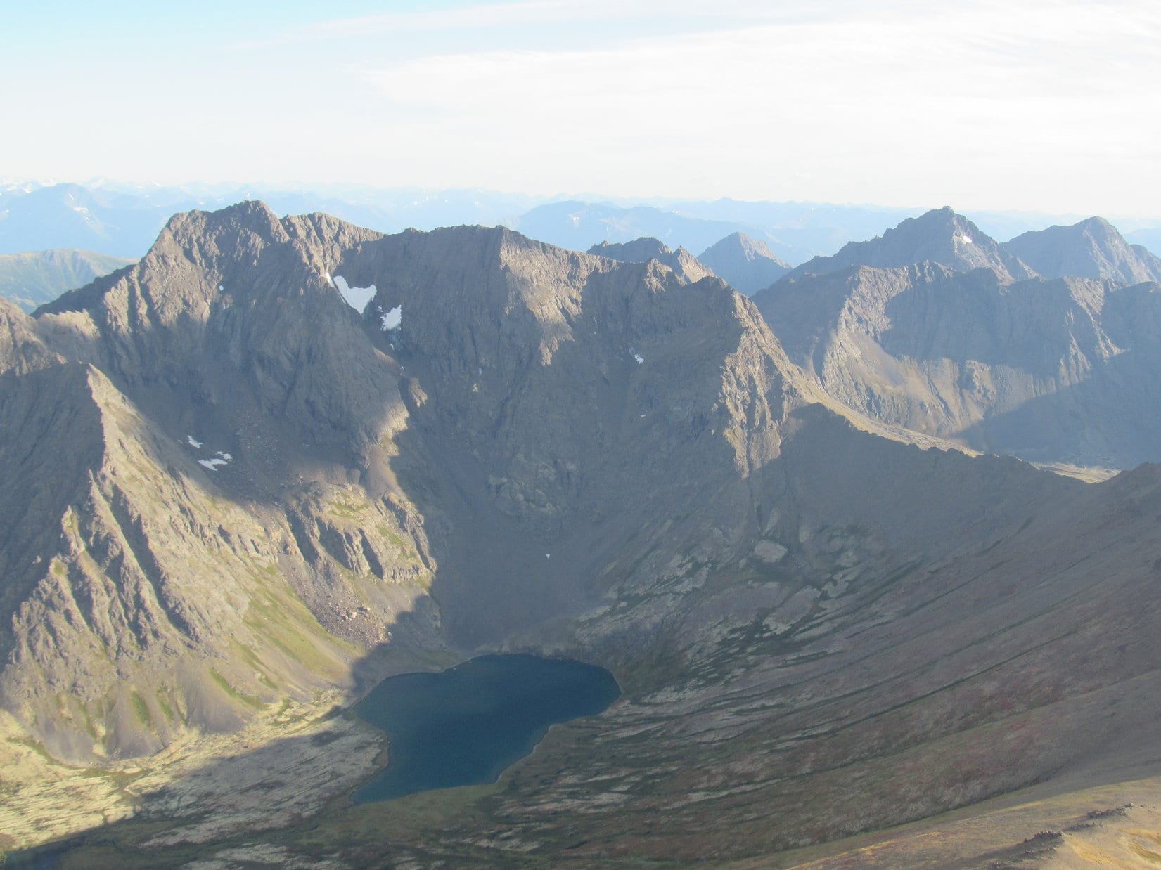
It seemed like a long climb, but the terrain finally started to level out.  Lupe reached The Wedge’s summit ridge near the NE end.  The true summit wasn’t far away at a rocky prominence.  While SPHP took a look an initial look around at the tremendous views, Lupe relaxed.

Lupe relaxes on The Wedge! The true summit is at the rocky prominence seen beyond her. The summit ridge went hundreds of feet farther beyond it. Photo looks WSW.

My, how those views had improved since Lupe started out way back down on the Powerline Trail!

The wide valley Lupe traveled through on her way to The Wedge is seen on the R. The first mountain beyond her (the one casting the dark shadow) is High Point 4160. The hill in sunlight beyond High Point 4160 is Flattop Mountain (3,510 ft.) near Anchorage. Cook Inlet and Anchorage are also in view. Photo looks WNW.
O’Malley Peak (5,150 ft.) from The Wedge. Photo looks NNW.
If Lupe had stayed on the Powerline Trail, she would have wound up at Powerline Pass(L). The small lake is Green Lake. Homicide Peak (4,660 ft.) is visible on the L beyond Powerline Pass. North Suicide Peak (5,065 ft.) appears above the ridgeline beyond Green Lake. South Suicide Peak (5,005 ft.) is to its R. Photo looks S.
Lupe’s next peakbagging destination, The Ramp, is seen here on the L. Part of the big saddle between The Wedge & The Ramp is seen in the lower foreground. Photo looks NE.
O’Malley Peak (Center) is the high point along the far ridge. Photo looks NNW.

The views of the nearby peaks were impressive, but far toward the E & SE horizons, Lupe could see even higher mountains and big snowfields.  The camera’s telephoto lens provided a better look at what was out there.

Wow! What’s that white monster peering over from behind the snowfield on the L? SPHP had no idea what peak that was. Photo looks E using the telephoto lens.
Looking S or SE toward fabulous remote mountains.

Naturally, Lupe went over to the true summit of The Wedge to claim her peakbagging success.

Lupe sits on the true summit of The Wedge. The Ramp is in view beyond her. Photo looks NE.
On the summit. Photo looks ENE.
A lone Carolina Dog stands astride the summit of The Wedge. Her next destination, The Ramp, is seen on the L. Photo looks ENE.

After half an hour spent on The Wedge, Lupe started her journey back down to the big saddle leading to The Ramp.  She stayed farther to the E than where she’d come up, hoping to see Ship Lake, which hadn’t been visible from the summit of The Wedge.  As she lost elevation, Ship Lake came into view.

Staying farther E coming down The Wedge, Lupe came to an amazing view of Ship Lake. Lupe is the tiny Dingo on the R. Photo looks ESE.
Ship Lake from the upper ENE slopes of The Wedge. Avalanche Mountain (5,000 ft.) (R) towers above the lake. Photo looks ESE.
Ship Lake through the telephoto lens.

Lupe continued on down toward the saddle leading to The Ramp (5,240 feet).  The Ramp is nearly 600 feet higher than The Wedge, and looked considerably steeper from afar.  The upper slopes were much more rugged, and the top of the mountain comes nearly to a point.  Lupe couldn’t expect any nice big summit area to relax on at The Ramp!

Looking at the summit of The Ramp through the telephoto lens. Lupe would try climbing up near the center of this photo a little to the L of all the steep ragged ridges. Photo looks NE.

SPHP started wondering if Lupe could even make it to the top of The Ramp?  Meaning, of course, SPHP wondered if SPHP could make it to the top!  The first part of the climb wouldn’t be bad, but the closer Lupe got to The Ramp, the more concerned SPHP became.

Meanwhile, Lupe was leaving Ship Lake and The Wedge farther and farther behind as she progressed across the saddle and started up The Ramp.

Ship Lake and Avalanche Mountain from the saddle between The Wedge & The Ramp. Photo looks SE.

Looking back across the saddle toward The Wedge from near the start of Lupe’s climb up The Ramp. Ship Lake is out of sight far down the slope to the L. Photo looks SW.
As Lupe started climbing The Ramp, Ship Lake and Avalanche Mountain receded behind her. Photo looks SSE.

For quite a long way, climbing The Ramp wasn’t any harder or steeper than climbing The Wedge had been.  However, the way up was slowly getting progressively steeper.  Lupe had already regained all of the elevation she’d lost going down from The Wedge and more, when suddenly a woman was in view above.  She was coming down toward Lupe.

Going up The Ramp.

Lupe and SPHP soon met up with her.  She had made it to the summit of The Ramp, and advised staying near the closest ragged, rocky ridgeline to the E where there was sort of an intermittent trail.  Near the very top, though, Lupe should swing around to complete her climb along the W ridge.  Going back down, Lupe could either return to the saddle or go down the W ridge, slowly turning SW into the valley.

SPHP thanked her for the advice, and she was gone.  She was the only person Lupe saw all day after the two women who had seen the moose early on.  The woman did seem to know what she’d been talking about, and apparently she’d made it to the top.  Per her advice, Lupe and SPHP angled over to the ragged ridgeline.

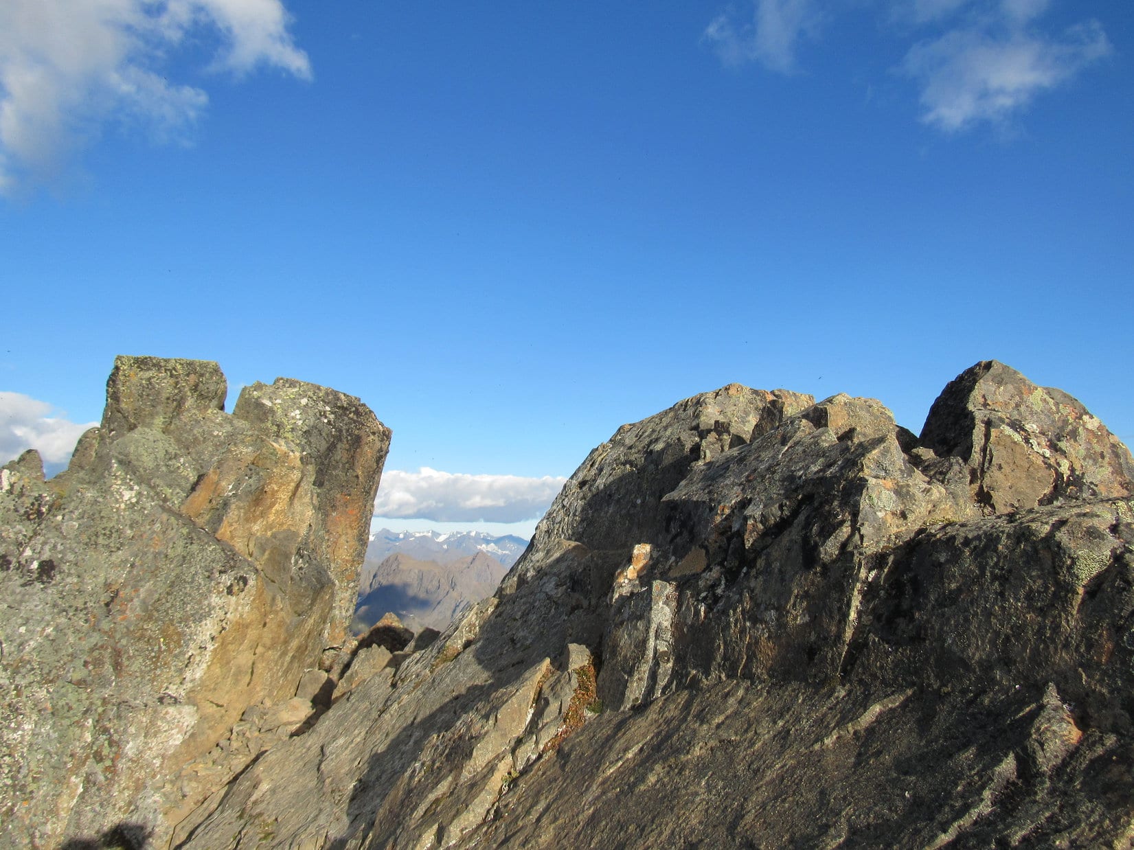
The woman was right.  An intermittent trail went up the ragged ridge.  Lupe had less loose rock to contend with.  There were also some fearsome drops only a few feet away on the E side of the ridge.  Lupe and SPHP kept climbing.  Lupe was getting there!  More and more of The Ramp was down below.  Less and less remained above.

Nearing the summit of The Ramp. Lupe made the last part of this climb along the W ridge, seen on the L. Photo looks N.

As the woman had advised, and the terrain virtually dictated, Lupe gained much of the last 60 feet of elevation by moving over to the W ridge and climbing up from that direction.  Very close to the top, Lupe traversed a narrow 30 foot long level ledge toward the SE, then scrambled 10 feet almost straight up to a small grassy area.

The narrow ledge had way more exposure than Lupe and SPHP are used to, but SPHP had good hand and foot holds all the way.  Lupe seemed unconcerned.  She had no problem crossing the ledge.  She scrambled up to the grassy area as easily as if she were only part Dingo, with a good dose of mountain goat in her.

At the little grassy area, Lupe was only 15 – 20 feet below the summit.  After a brief pause, Lupe and SPHP finished the climb.  The last 10 feet were very steep, but once again, there were good hand and foot holds.  Lupe managed to get all the way up to sit a only a foot or two below the tops of the highest rocks at the summit of The Ramp.

SPHP wouldn’t let Lupe go up that last foot or two.  Huge exposure was only a couple feet away to the N.  This was it.  Close enough for Dingo work!  Lupe was claiming her peakbagging success!  With one hand, SPHP clung to the rocks, while operating the camera with the other.

Lupe perches next to the very highest rocks of The Ramp. Want to know how large the summit area was? You’re looking at it! Photo looks E.
Part bird, part mountain goat, part Dingo! Lupe sits on top of The Ramp with incredible views in every direction. Photo looks SE.
Lupe at the top of The Ramp. Photo looks ESE.
Yeah, SPHP, there’s a helluva view from up here, but you know what? So far, not a squirrel in sight!

Of course, the views were amazing from The Wedge.  In fact, they were dizzying.  SPHP clung to the rocks, taking pictures.  At SPHP’s bidding, Lupe got down off the summit.  She retreated to a less precarious position close to the grassy area where she could rest comfortably, while still enjoying the stupendous view.  SPHP soon joined her.  Wow, what an incredible place!

O’Malley Peak (5,150 ft.)(L of Center), Hidden Peak (5,105 ft.)(Center), and Wolverine Peak (4,491 ft.)(R) from The Ramp (5,240 ft.). Photo looks NW.
Looking down on some of the Williwaw Lakes in the valley of the Middle Fork of Campbell Creek. Wolverine Peak is on the L. Mount Elliot (4,710 ft.) is the closest mountain beyond the lakes. The Tanaina Peaks and Tikishla Peak are along the big ridge beyond Mount Elliot.  Photo looks N.
Looking SE using the telephoto lens.
Ship Lake and Avalanche Mountain from the summit of The Ramp. The Suicide Peaks are visible on the R. Photo looks S.
The Wedge(L) looks much smaller from the summit of The Ramp. The broad valley seen below is the one Lupe came up on her way to The Wedge after leaving the Powerline Trail. Photo looks SW.
O’Malley Peak using the telephoto lens. Photo looks NW.
Some of the Williwaw Lakes using the telephoto lens. Photo looks N.
Summit of The Ramp. Photo looks ESE.
Lupe chillin’ a little below the summit. She has a view of part of Ship Lake and Avalanche Mountain on the L. The Suicide Peaks are straight up from her head. On the R is the saddle she crossed coming here from The Wedge. Photo looks S.

After 15 minutes doing nothing other than enjoying the views together, Lupe and SPHP started down.  Once safely past the 10 foot down climb and 30 foot ledge, SPHP felt more relaxed about the situation.  A long pleasant evening trek down the mountain ensued.  Lupe took the alternate route down along the W ridge, eventually dropping well below it on her way to the valley.

Going down the W ridge line. O’Malley Peak on the R. Photo looks WNW.

The route stayed steep and rocky for a long way.  Slowly the slope decreased. Tundra vegetation started taking over, and the way became less rocky.  For Lupe, this was the best part of the entire excursion.  For a long time, she ran free over great distances to her heart’s content.  The tundra glowed with color in the evening light.  The air was fresh and cool.  Lupe was in American Dingo paradise!

The Wedge as seen from the N side of the broad valley. Photo looks S.
Lupe in American Dingo paradise.
Only one question. Where do they keep the squirrels around here? I’ve searched everywhere!

Of course, Lupe always remembered to come running back to SPHP at frequent intervals, even though it was a chore having to constantly regain all the elevation she’d just lost.

Lupe comes running back to check on slowpoke, SPHP. Lupe’s route up The Wedge earlier in the day is in view here. She started up the low ridge at center, following it all the way to the L, then curving back up toward the R to reach the top. Photo looks S.

Lupe and SPHP saw no one in the broad valley.  The return trip was a glorious, peaceful, happy time.

SPHP has no idea what sort of plant these are, but they were soft and beautiful. They decorated the tundra in scattered clumps.
The wonderful, colorful tundra.

The wonderful, amazing Carolina Dog! She seemed fairly satisfied with the way this adventure turned out!

By staying farther N in the valley, Lupe was able to avoid most of the boggy terrain lower down.  SPHP even found a way over the tributary of the South Fork of Campbell Creek without having to ford it again.  By the time Lupe was getting close to the Powerline Trail again, the sun was disappearing behind the mountains far to the W beyond Cook Inlet.

The sun disappears on the W horizon behind mountains beyond Anchorage and Cook Inlet. The Knik Arm is seen on the R.
A final look back at the now distant big saddle between The Wedge (R) and The Ramp (L). Photo looks SE.

As Lupe and SPHP finally drew near the turn off the Powerline Trail leading to the Glenn Alps Trailhead, some of the lights of Anchorage came into view.  Mountains were silhouetted against an orange sky beyond the Knik Arm of Cook Inlet.

Some of the lights of Anchorage came into view from the Powerline Trail. Photo looks NNW.
Anchorage, Alaska

SPHP remembered there was a small hill near the upper Glenn Alps Trailhead parking lot where the G6 was.  Why not spend a view extra minutes to climb it and get a sweeping view of the lights of the entire city of Anchorage?  It sounded like a great idea!

Lupe never got to.  Someone else had the same idea, and had already claimed both the hill and the view as their own.  (10:33 PM)Note:  The Glenn Alps Trailhead is on the SE edge of Anchorage.  To get there, take O’Malley Road off Seward Highway going E toward the mountains.  Turn R on Hillside Drive, L on Upper Huffman Road, and follow the signs to Toilsome Road.  The upper trailhead parking lot is at the end of Toilsome Road.

Links:

Chugach State Park

Chugach State Park Map

Chugach State Park Brochure

Next Adventure              Prior Adventure

Want more Lupe adventures?  Choose from Lupe’s 2016 Canadian Rockies, Yukon & Alaska Adventure IndexDingo Vacations Adventure Index or Master Adventure Index.  Or subscribe free to New Lupe Adventures.

Black Hills, SD Expedition No. 199 – Twin Sisters Twice & Castle Rock (4-12-17)

Start (10:25 AM, 54°F), intersection of Dog Song Road & USFS Road No. 373, 4 miles SE of Pringle.

Cool rainy weather, even a skiff of snow, had delayed Expedition No. 199 for several days, but Lupe was finally on her way!  Although she had finished up the last of the Brian Kalet peaks she was going to climb in the southern Black Hills on Expedition No. 198, she was still headed S, just not quite as far S as before.

Lupe’s first peakbagging objective for the day was the high point of the Twin Sisters Range (4,980 ft.).  The Twin Sisters Range is really no more than a 2 mile long ridge running E/W within the Black Hills.  For some reason this ridge, which isn’t particularly high even compared to nearby terrain, has its own name on the maps while countless similar ridges do not.

No matter, if the Twin Sisters Range was on the maps, that was good enough for Lupe!  After she reached the high point, the plan was to explore much of the rest of the ridge.  Maybe Lupe would even go on to Elk Knob, another minor high point 0.5 mile farther S?

Approaching the area from the W, it became clear Lupe would not only have an easy time up on the ridge, she would have some great views, too.  The Twin Sisters Range looked barren and exposed.

The W end of the Twin Sisters Range looked barren and exposed. Lupe was going to have some great views up there! Photo looks E from Dog Song Road.
At the starting point. The G6 is parked just off Dog Song Road (not pictured). Lupe would follow USFS Road No. 373 to get to the W end of the Twin Sisters Range, about a mile E of here. High Point 5017 is the ridge seen in the background. Photo looks SE.

From the G6, Lupe followed USFS Road No. 373 going E toward the W end of the Twin Sisters Range.  This was a super easy, level stroll in upper Cold Spring Creek valley.  The creek must have been underground here.  It was nowhere in sight.  A steady E breeze made the day seem cooler than it really was, but meadowlarks were singing cheerfully.  Lupe was cheerful, too!  She liked this place.

Shortly after setting out, Loop reached a locked gate across No. 373 at the W end of an area serving as the water supply source for Wind Cave National Park.  The 0.5 mile long area is not connected to the rest of the park, located 2 miles farther E.  No vehicles could go beyond the locked gate, but Lupe could.  It didn’t take her long to reach the far E end where she found no gate, only a cattle guard.

After passing through the park water supply area, No. 373 angled SE and entered a thinly forested area.  Lupe began to gain elevation.  The W end of the Twin Sisters Range was now close at hand.

Getting close to the W end of the Twin Sisters Range. Photo looks E from USFS Road No. 373.

Lupe followed No. 373 gradually uphill until she was SW of the W end of the Twin Sisters Range.  Here, SPHP led her off the road to begin the real climb.

Lupe and SPHP left the road to begin the climb up to the W end of the ridgeline here. Photo looks NE.

After all the cactus she had been having to dodge for the last couple of months while climbing Brian Kalet peaks farther S, Loop wasn’t at all certain leaving the road was a good idea.  In fact, she was pretty positive it wasn’t.  This barren ridge looked a lot like some of those cactus-infested areas.  She begged SPHP to carry her.

The Twin Sisters Range was a few hundred feet higher than most of the peaks Lupe had been climbing lately.  It was definitely sunny and exposed, which is good for cactus, but SPHP hadn’t seen any yet.  Maybe this area was high enough to be above cactus line?  Cactus usually disappears somewhere in the 4,700 to 5,000 foot range in the Black Hills.

SPHP didn’t carry Lupe, only encouraged her to keep climbing.  She followed somewhat reluctantly.  However, her confidence grew as she made rapid progress up the slope without encountering any cacti.

Shortly before reaching the ridgeline, there was movement on the ground.  Lupe saw a snake!   It was gray-green and smallish, but coiled up and surprisingly active.  SPHP didn’t know what kind of snake it was, but it was clearly harmless.

Lupe came across this snake as she neared the top of the ridgeline. It was harmless, but surprisingly active on this cool, breezy day.

Even though the snake was harmless, SPHP was a little concerned about seeing it.  The snake seemed plenty lively despite the cool, breezy day.  Snakes are quite rare in most of the Black Hills, but are much more common at lower elevations.  In all her expeditions and adventures in the Black Hills, Lupe has never seen a rattlesnake.

One of the reasons Lupe had been climbing the lower Brian Kalet peaks of the southern hills early in the year when it was cold out was to avoid encountering rattlesnakes.  Due Lupe’s small size, a rattlesnake would be much more of a danger to her than to SPHP, and she might not know to stay away if she came to one.

Lupe might be above cactus line here, but seeing the harmless snake proved she wasn’t above snake line yet.  SPHP couldn’t ever remember seeing a rattlesnake above 5,500 feet in the Black Hills, but that was more than 500 feet higher than the Twin Sisters Range.  Seeing the harmless snake also proved spring had progressed far enough along so snakes were now active.

Dry, sunny, and topped by a layer of weathered limestone undoubtedly offering plenty of little caves and crevasses to hide in, the Twin Sisters Range did look like prime rattlesnake country.  Still, seeing a single harmless snake didn’t mean the area was infested.  SPHP encouraged Lupe to stay close from now on, though, as she finished her climb.

It only took Lupe a couple more minutes to reach the top at the W end of the ridge.  The views were excellent!

Lupe reaches the W end of the Twin Sisters Range ridge. The views were excellent! Without any trees around, Loop could see in every direction. Photo looks W at the Cold Springs Creek valley she had traveled through to get here.
The high point of the Twin Sisters Range (R) from near the W end of the ridge. Photo looks ENE.

The Twin Sisters Range High Point (4,980 ft.) was less than 0.25 mile away.  An easy stroll E along the ridge, and Lupe was claiming her first peakbagging success of the day!  That was easy!

Lupe reaches the summit cairn at the Twin Sisters Range High Point. Photo looks W.
At the summit cairn. Photo looks E.
The lower end of the Cold Spring Creek valley. Photo looks ENE.

With the 360° view available from the Twin Sisters Range High Point, Lupe could see many mountain peaks she had visited in the past, including a lot of the ones she had been to in the last couple of months in the southern Black Hills.  Most of them were many miles away.

Looking N toward Northeast Cicero Peak (6,240 ft.)(Center). Mount Coolidge (6,023 ft.)(far R) is also in view.
High Point 5017 is the large, barren ridge in the foreground. On the far horizon are Parker Peak (4,848 ft.)(L) and Matias Peak (4,780 ft.)(Center). Photo looks SW.
Much of the territory around (and including) the Twin Sisters Range had burned years ago. This photo looks NW at some of the devastation.

From the summit, Lupe could see the rest of the Twin Sisters Range ridgeline to the E.  She would get to explore much of this territory on her way to Elk Knob.  It looked like fun!  The Carolina Dog would enjoy great views all the way.

Looking SE at the rest of the Twin Sisters Range ridgeline. Lupe would have a great time exploring it on her way to Elk Knob! Buffalo Gap is in view in the distance at the edge of the hills a little R of Center. Peak 4160 is the long ridge to the L of it at Center. Unkpapa Peak (4,280 ft.) is the long ridge to the R. Lupe had been to both only 10 days ago on Expedition No. 198.

After enjoying the views from the breezy summit, Lupe headed SE down the ridge starting her trek to Elk Knob.  For 5 minutes, it was fun being able to see so much.  In an instant, everything changed.

Looper, you OK?!

Yes, of course!  You were right, no cactus up here.  Makes life a lot more pleasant!  This is way better than some of those other mountains.

Yeah, but we’re not staying.  Time to go!  There’s worse things than cactus.  Hear that buzzing?

With these big soft Dingo ears, how could I not hear it?

Well, remember that sound.  That’s a rattlesnake.  Poisonous, perhaps deadly to Dingoes if one bites you!  We must have passed within a few feet of it seconds ago.  It’s right over there somewhere.  Stay here!  Don’t go over there.

Yikes!  Are you serious?

Very.  Two snakes in what, maybe 20 minutes, up here?  One of them poisonous.  It changes everything.  We aren’t going to spend hours strolling around on Rattler Ridge courting disaster.  Forget that.  If you like this place, we can come back another time, like on a warmish day in December or January.  Won’t be any snakes then.

Yeah, suddenly I’m thinking this place would look gorgeous with a couple inches of snow on the ground!

Yup, exactly, let’s skedaddle, but stay close till we’re down off this ridge.

The buzzing had lasted maybe 20 seconds before it stopped.  SPHP pitched 8 or 10 rocks back toward the source, but the buzzing didn’t start up again.  SPHP walked a little closer, but saw nothing.  Maybe the snake had slithered into some hole?  Didn’t matter, there wasn’t any doubt.  A rattler had been there.  Elk Knob wasn’t happening.  Not today.  No way!

Looking NW back up at the Twin Sisters Range High Point. This was as far as Lupe got on her way to Elk Knob due to the rattlesnake she’d heard only a few minutes ago.

Lupe didn’t go back up to the Twin Sisters Range summit.  She took a shortcut going SW down off the ridge.  This route was more direct and less steep than the way she’d come up.  She came to no more snakes.

The return trip to USFS Road No. 373 was uneventful.  SPHP did see the one and only cactus patch of the day, but it was easily avoided.  The most exciting thing Lupe encountered along the way was some sort of huge ant festival going on at a rotting log.

Lupe starts down the S side of the ridge. If you want a good idea of what prime rattlesnake territory looks like, this is it. Photo looks W.
Lupe saw no more snakes. The most exciting thing she saw coming down off the ridge was this big ant festival being held at a rotten log.

All’s well that ends well.  Loopster reached USFS Road No. 373.  At least she had made it to the top of the Twin Sister’s Range High Point!  Elk Knob could wait.

On the way back to the G6 along USFS Road No. 373. Photo looks WNW.

The stroll back to the G6 along the road was nice and relaxing.  The whole journey to the Twin Sisters Range High Point hadn’t taken long, only a little over an hour and a half (12:07 PM, 54°F).  There was oodles of time left in the day.

That was OK!  SPHP had a backup plan.  There was another Twin Sisters on the maps Lupe could visit.

On the way back to Hwy 89 on Dog Song Road, SPHP stopped the G6 for this look back at the Twin Sisters Range High Point (L). Goodbye Rattler Ridge! Photo looks E.

Well, Loopster, that was it!  We are done with this low country stuff now until it gets cold again in the fall.  No more cactus.  No more snakes.  We are staying high.  If we manage not to fall off of anything and can avoid the barbed wire, we should be golden.  Of course, there’s always mountain lions, and hunters, but oh well, never mind.  We’ll be fine.

That sounds, great!  I can’t tell you how sick I was getting of cactus.

No doubt, but you were getting better at handling it, too.  We had fun!  Saw some great stuff.

Maybe, not nearly enough squirrels, though.  So where we going now?

Twin Sisters again.  Another Twin Sisters (5,920 ft.), a different one.  These next Twin Sisters are W of Custer.  They are nearly 1,000 feet higher than the ones we just left.  Should be plenty of trees, no cactus, no snakes, and maybe you will see some squirrels.

I hope you’re right.  Strange that both places have the same name.

Yeah, actually, there is a third set of Twin Sisters (5,244 ft.) in the Black Hills, too.  It’s even farther N, between Pactola and Sheridan Lakes, practically right off the Centennial Trail.  You’ve already been there, but it was a long time ago.  You weren’t even 14 months old yet.  So after this next set, you will have visited 3 different Twin Sisters in the Black Hills.

Like a whole litter of sisters!

You could say that.

When Lupe jumped out of the G6 again at Comanche Park campground off Hwy 16, she knew instantly this place was more to her liking (12:59 PM, 52°F).  She sniffed the air briefly, then took off running in circles.  It was true!  No more cactus!  One of the first trees she checked even had a squirrel in it!  Things were definitely looking up.

The new Twin Sisters were less than 2 miles away.  Lupe and SPHP headed S through Comanche Park campground.  A little beyond it, a few houses were around, part of some subdivision, but the private property wasn’t hard to avoid.  Most of the area was national forest land.

The terrain Lupe traveled through was rolling and forested.  Much of the forest had been thinned, so it was quite open and easy to see what was ahead.  Before long, the N Twin Sister (5,920 ft.) was in view.  It was the highest of the two.

The N Twin Sister comes into view S of Comanche Park campground. Photo looks S.

Lupe headed straight for the mountain.  As she got closer, it looked like it might be best to start up along the NW ridge.  The climb wasn’t difficult, although it became steeper as Lupe got higher up.

When she was already fairly high, Lupe reached a prominent point capped by some unusual looking rocks.  The rocks formed a couple of platforms, one large and one small.  Lupe got up on both to look around.  From the smaller platform, she had a decent view to the NNE.

Lupe on the small platform of cool rocks on her way up the N Twin Sister. She was already high enough to have a pretty decent view from here. Photo looks NNE.
A happy finally-out-of-cactus-country American Dingo on the smaller platform. Sylvan Hill (7,000 ft.) is the distant ridge on the R. Photo looks NNE.

Trees blocked the views from the larger platform.  Still, it was fun climbing around on the interesting rocks.

Lupe below the highest rocks of the larger platform.

Lupe finished her climb following the N ridge.  The route was modestly steep, but not difficult.  Soon Looper was standing on a stump at the very top of the N Twin Sister.  Since this was the highest sister, she’d already accomplished her peakbagging goal here.  Easy, squeezy!

Ta da! Lupe stands on a stump at the summit of the N Twin Sister. Since this was the highest one, she was able to claim another Dingo peakbagging success! The S Twin Sister is in view beyond her. Photo looks S.

The summit area was plenty roomy.  Three prongs radiated out from the central high point.  One off to the N, one to the E.  The third and longest prong sloped down to the SW.  The views were best from the two shorter prongs, due to breaks in the forest.

Looking NNW from the N prong.
Lupe at the edge of the E prong. Northeast Cicero Peak (6,240 ft.) (Center) is the high point on the horizon. Photo looks ESE.
The summit area on the N Twin Sister was plenty roomy. This photo looks W from the E prong, and shows more than half of the summit area.

Lupe and SPHP took a break near the summit.  Lupe had her Taste of the Wild and water.  SPHP consumed an apple.

A number of birds were flying around.  The Bluebird of Happiness showed up and hung around for quite a while.  Lupe was glad to see him!  She was certain now that her past few months of cactus ordeals were over.  The Bluebird of Happiness would never steer you wrong, would he?

The Bluebird of Happiness paid Lupe a visit up on the N Twin Sister. It had been a year since she’d last seen him up on Twin Buttes (4,949 ft.) during Expedition No. 166.  Maybe the Bluebird of Happiness had a thing for twins?

After the break, Lupe went down into the saddle leading to the S Twin Sister.  It was an easy jaunt down a modestly steep slope.  The climb up the S Twin Sister was steeper, but not bad.  A lot more rocks were over here.  Lupe went up along the NW side since there were cliffs on the N and NE sides.

Lupe got up on the cliffs for a look back at the N Twin Sister.

On top of the cliffs along the NE edge of the S Twin Sister. The N Twin Sister where she had just been is in view. Photo looks N.

The S Twin Sister had a much larger summit area than the N Twin Sister.  There were two high points, one to the N and one to the S.  The N one seemed to be a little higher than the S one, but Lupe found great viewpoints from both.  Trees always blocked the views to the NW, but it was possible to see in any other direction from some part of the mountain.

Lupe took a tour of the entire summit area.  She enjoyed lots of fabulous views.

Lupe at the edge of the S rim of the S Twin Sister. Parker Peak (4,848 ft.) (L) and Matias Peak (4,780 ft.) (Center) are barely in view in the haze on the horizon. Photo looks S.
Peak 5846 is the closest big ridge on the R. Photo looks SE.
Lupe stands at the SW end of the S Twin Sister. A lower rock platform seen on the R stuck out a little farther to the W. A small connecting saddle made it possible to get onto the lower platform. Photo looks SSW.
Looking down across a gap toward the lower platform. Photo looks SW.
The view through the gap between the platforms. Photo looks SSE.
Looper on the lower platform. Photo looks S.
Can I come down yet? …. Sure, that was great Loop, thank you!
Lupe at the S high point of the S Twin Sister. The topo maps give the elevation here as 5,889 ft. Photo looks NNE.

After touring the whole area near the S high point, Lupe returned to the cliffs near the N high point for a final look around.

The N Sister (L) from the cliffs at the N end of the S Sister. The large gray rock formation sticking up out of the forest on the R is Castle Rock. Photo looks N.
Loop on top of the cliffs along the far NE edge of the S Sister. Peak 5846 (Center) is the first big ridge seen in the distance beyond her. Photo looks SE.
Looking S across the summit area of the S Twin Sister from near the N end.

Having completed her explorations of the S Twin Sister summit, Lupe went back down the NW slope and crossed the saddle over to the N Twin Sister.  Down in the saddle she found a pretty grouping of crocuses.

Crocuses (officially Pasque flowers) are the state flower of South Dakota. They bloom in early spring in the Black Hills.

Lupe returned briefly to the summit of the N Twin Sister before heading down the N ridge.

Lupe back at the summit of the N Twin Sister. Photo looks N.

On the way down the N ridge, Lupe could sometimes see a large, gray rock formation off in the forest to the NNE.  This was Castle Rock (5,600 ft.).  SPHP had also caught a glimpse of Castle Rock off to the E on Lupe’s way to the Twin Sisters.  It wasn’t terribly high, but the sides looked like nearly vertical walls – not anything a Dingo could climb.

Castle Rock as seen on Lupe’s way down the N ridge of the N Twin Sister. Photo looks NNE using the telephoto lens.

Despite not being any larger than hundreds, maybe thousands, of similar rock formations in the Black Hills, Castle Rock had its own name and was shown on the maps.  Since it was kind of on the way back to the G6, SPHP thought Lupe might as well go check it out.  Even if she couldn’t climb Castle Rock, she could say she’d been there.

Surprisingly, when Lupe arrived, it looked fairly easy to climb at least partway up from the S end.  Lupe began climbing.  She needed a boost at one scrambly spot, but to SPHP’s amazement, she made it all the way to the top of Castle Rock!

To SPHP’s amazement, Lupe made it all the way to the top of Castle Rock. Photo looks N.

Castle Rock wasn’t all that tall, but it jutted up high enough to be well above the surrounding forest.  Consequently, Lupe had views in every direction.  The true summit of Castle Rock was near the N end of the formation where several large boulders sat on the rest of the granite.  Lupe got up on one of these boulders.

Lupe on one of the huge boulders at the true summit near the N end of Castle Rock. Photo looks N.
Hah! And you thought I couldn’t do it, SPHP. Not a bad Dingo perch either, I can see for miles! Photo looks SSW.

After scanning the forest below for deer and squirrels from her lofty perch, Lupe got off the big boulder to explore the summit area some more.  It wasn’t very large, but was kind of dramatic with all the huge rocks around and cliffs to the E & W.

Lupe exploring the summit area. Twin Sisters are in view on the L. The highest boulder of all on Castle Rock is seen on the R. Photo looks SSW.

Of course, the Twin Sisters where Lupe had just been were in view to the SSW.

Twin Sisters (Center) from Castle Rock. Photo looks SSW.

After a brief summit area inspection, Lupe returned to the huge boulder.

Lupe returns to her lofty perch. Photo looks N.

After a few more minutes enjoying the views from her favorite lofty perch, it was time to go.  Retreating back down the S end the way she had come up was the only feasible route.  Soon Lupe was down and on her way back to the G6.

Looking back at Castle Rock from the W.

Expedition No. 199 should have been over now for all practical purposes, but by the time Lupe made it back to the G6 (5:34 PM, 52°F), SPHP had hatched a new plan.

Near Mount Rushmore is another mountain shown on the maps called Old Baldy Mountain (5,605 ft.).  Lupe had never been there, even though it was in the Peakbagger.com data base.  SPHP had always assumed based on its location near many other impossible-for-a-Dingo-to-climb soaring granite formations that Lupe wouldn’t be able to climb Old Baldy.

However, Loopster’s unexpected success reaching the top of Castle Rock made SPHP start thinking maybe she could also get to the summit of Old Baldy Mountain?  Time to check it out!

On the way home, Lupe dropped by the Wrinkled Rock Climbing Area (6:09 PM, 50°F).  A short walk along one of the paths brought Lupe to a view of Old Baldy Mountain.

Forget about this one, SPHP, unless you’re ready to spring for a helicopter ride! This one’s not happening! Old Baldy Mountain (Center). Photo looks ENE.

Directions:

Twin Sisters Range High Point: Dog Song Road (USFS Road No. 682.1) leaves Hwy 89 1.7 miles S of Pringle.  The junction with USFS Road No. 373 is 3 miles from the highway.

Twin Sisters (W of Custer): Comanche Park campground where Lupe started is 6 miles W of Custer on the S side of Hwy 16.  However, it may be possible (and necessary when the campground is open) to start much closer on an alternate route from the E.  Click here for details.

Links:

Next Black Hills Expedition                  Prior Black Hills Expedition

Want more Lupe adventures?  Check out her Black Hills, SD & WY Expeditions Adventure Index, Master Adventure Index, or subscribe free to new Lupe adventures!