Start 9:16 AM, 48°F, Boulder Hill Road (USFS Road No. 358) 0.5 mile N of Hwy 16.
Note: Summits on the Air is an awards scheme for radio amateurs that encourages portable operation in mountainous areas. A point system awards points for both transmitting (“activating”) from a mountain or picking up the signal (“chasing”).
Joe & cousin Dusty were in town! That meant one thing – time for some Summits on the Air action! Lupe was all for it. She and Dusty arrived at the top of Silver Mountain around 10 AM. It was a beautiful day to be on the mountain.
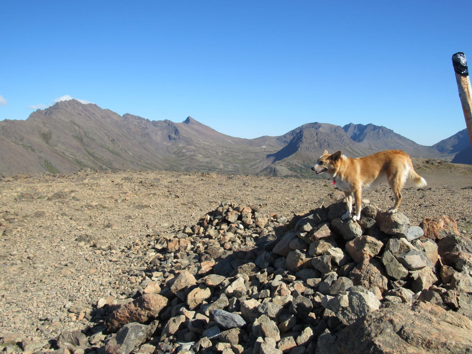
Lupe hadn’t been on Silver Mountain in more than 2 years. Although the views are excellent, Silver Mountain is not one of Lupe’s favorites. Target practice gunfire can usually be heard off to the W, which makes her nervous. To Lupe’s dismay, the guns were blazing away again today. Boulder Hill(5,331 ft.) is in view on the L. Photo looks NE.Cousin Dusty just below the summit. The distant gunfire didn’t bother Dusty at all. She paid not the slightest attention to it.Dusty lives in Arvada, Colorado, but was up in South Dakota for a weekend visit. Dusty really likes exploring the Black Hills with Lupe.
Joe had posted notification on the Summits on the Air website that AA0Q (his call letters) would “activate” (start transmitting from) Silver Mountain at 11:00 AM. With an hour to go, he had plenty of time to set up his antenna and portable Ham radio.
Preparations to start transmitting from Silver Mountain included setting up this 16 or 17′ long antenna with four lateral wires at the very summit. Photo looks NE.
Joe said he liked the layout on Silver Mountain(5,405 ft.). The forest had burned years ago, so there were no big trees around to obstruct the views in any direction. The mountain sloped away fairly steeply on most sides with nothing any higher for at least a couple of miles in any direction.
Although Silver Mountain was a good physical setup for Ham radio transmissions, Joe wasn’t at all certain how well things were going to work out. The 11 year sunspot cycle hits its low in just a couple more years, and atmospheric conditions are usually best for amateur radio band transmissions when sunspot activity is high, not low.
As it got close to 11 AM, everything was ready to go. The antenna and portable radio were all set up. SPHP was trained to keep a simple log of Joe’s contacts. Lupe and Dusty were prepared to ward off any intruders.
At 10:55 AM, Joe started transmitting in Morse code, receiving a first response almost instantly. That contact “spotted” AA0Q on SOTA’s website confirming contact with Joe. Silver Mountain was on the air!
An immediate explosion of activity came from dozens of “chasers” all trying to make contact at the same time. AA0Q was overwhelmed by the response, as usual. Joe did his best to make rapid contact with as many of the chasers as possible, but it was impossible to respond to more than a fraction.
AA0Q hard at it shortly after “activating” Silver Mountain. Photo looks SE.Dusty relaxes nearby while Joe works the Ham radio. Response from the chasers, as usual, was initially overwhelming.
Atmospheric conditions were changing rapidly. Joe and the chasers often exchanged signal strength information, which varied wildly over the span of only a few minutes. Of course, part of the variation was due to the different locations of the chasers. Successful contacts were made with operators in Arizona, California, Pennsylvania, the Carolinas and several other states.
With chasers lined up in droves trying to get through, each contact had to be brief.
So, Uncle Joe, how is it going? Heard anything from anyone on Squirrel Mountain, yet? Lupe checks on AA0Q’s SOTA progress. Photo looks E.This photo shows the overall setup. The rocky summit ridge wasn’t the best for comfort, but AA0Q managed pretty well. Photo looks NNE.AA0Q’s portable radio in use on Silver Mountain.
For the first 10 or 15 minutes, conditions gradually improved. Signals were getting a little stronger on average, despite bouncing around. Later on, conditions deteriorated. At times the “bands” were down for a minute or two. AA0Q got a chance to shift to a more comfortable position.
As time went by, the bands went down intermittently, giving Joe a chance to shift to a more comfortable position. Photo looks SSW.
By 11:30 AM, 35 minutes after Joe started transmitting, it was over. The bands were consistently weak. The chasers had either made contact with AA0Q, or given up by now. Even when conditions improved momentarily, no one was left still trying to make contact. Evidently it was time to take down the antenna and put the radio away.
Joe at the top of Silver Mountain shortly before taking the antenna down. Photo looks NNE.Silver Mountain was the 3rd Black Hills peak AA0Q has activated. In July, 2016, Lupe and SPHP had accompanied Joe & Dusty to Custer Peak and Boulder Hill.
AA0Q had made 27 contacts in 35 minutes, so Joe was pleased with the overall results. Despite spotty atmospheric conditions, Silver Mountain had been a successful Summits on the Air outing. There always seem to be way more chasers than it’s possible to make contact with right after activating a peak, but Joe had done all he could.
Lupe got a pat from AA0Q for her guide services.
Lupe earns a pat from AA0Q for her Black Hills peak guide services. Photo looks NE.
Once the radio equipment was put away, it was time for a final look around at the views, followed by a short exploration of Silver Mountain’s summit area. Of course, the most impressive view was toward Black Elk Peak(7,231 ft.), the highest mountain in South Dakota.
Black Elk Peak(7,231 ft.) (R of Center) from Silver Mountain. Hwy 16 is seen below. Photo looks SW.
Silver Mountain’s summit area features two ridges running roughly N/S. The E ridge where Joe had set up the radio equipment is the highest. However, only a short distance to the W is an even rockier and more interesting ridge. The W ridge is only slightly lower than the E one.
The slightly lower, but more dramatic W ridge. Photo looks NW.
Between the two ridges, at the base of the E one, is one of many Dingo outposts Lupe has discovered scattered throughout the Black Hills.
Joe inspects Lupe’s Silver Mountain Dingo outpost. Joe was pretty certain it didn’t meet current building codes, but adventurous American Dingoes don’t give two hoots about that. Boulder Hill is in view beyond it. Photo looks NNE.
Joe was intrigued by the W ridge. He got up on top for a few minutes for a look around. Lupe and Dusty stayed below.
Joe got up on the W ridge for a look around. Slightly lower, Lupe is partially hidden among the small trees on the L, while Dusty sniffs around in the foreground. Photo looks W.
With Silver Mountain’s summit area explored, everyone headed back to the G6. There was still tons of time left in the day. Joe wanted to go climb Boulder Hill (5,331 ft.) again. Everyone piled into the G6. Joe drove 0.5 mile N to the start of the access road only 0.25 mile SW of the summit.
An easy trek along the access road led to a scenic path that winds up the large rock formation at the top of the mountain. Soon Lupe was at the summit with a great view looking back at Silver Mountain(5,405 ft.).
Silver Mountain (Center) from Boulder Hill. Photo looks SSW.
Joe has liked Boulder Hill ever since first climbing it with Lupe, Dusty and SPHP exactly one year ago on 4-22-16. In fact, he liked it so much that first time, everyone had come back to make a second ascent the very next day! On the 4th of July, Joe had even done a Summits on the Air activation of Boulder Hill.
Today’s Expedition No. 201 was Joe and Dusty’s 4th time up on Boulder Hill with Lupe and SPHP. Good times!
Joe on Boulder Hill near the area where he’d done a Summits on the Air activation of the peak on 7-4-16. Back then his antenna had been propped up in the big pine tree seen directly beyond him. Photo looks NW.Joe & Dusty together with Lupe on top of Boulder Hill for the 4th time. The first time up for Joe and Dusty had been exactly one year ago! Photo looks SE.
No Summits on the Air activation of Boulder Hill was planned for today. This was a pleasure excursion, just to see the views.
Silver Mountain (L). Photo looks SSW.Silver Mountain with a little help from the telephoto lens. The more dramatic, rocky W ridge is seen to the R of the true summit. Photo looks SSW.
After lingering at the top of the mountain for 15 minutes, everyone started back down. Time to head back to Lupe’s grandma’s house for food, fun and games. Lupe and Dusty looked forward to an afternoon of squeaker ball, tennis ball and flying disc action in grandma’s front yard. (End 2:00 PM, 62°F)
Joe (lower R) starts the trek down. Photo looks S.Lupe’s cousin Dusty on Boulder Hill. Photo looks E.
Day 32 of Lupe’s Summer of 2016 Dingo Vacation to the Canadian Rockies, Yukon & Alaska
The replacement part didn’t look the same as the original one. Figures. SPHP didn’t have the tools, or the knowledge required to fix the problem. Better not mess with it any more. For some reason, lots of bees were flying around the O’Reilly Auto Parts store parking lot, and SPHP is allergic. Time to get out of here! Even though the G6’s right front headlight still wasn’t working, SPHP reassembled everything.
When SPHP had taken it all apart, hoping to simply replace the low beam headlight bulb, it turned out that wasn’t the problem. The bulb was fine, but the socket it fit into was partially melted. O’Reilly had the replacement part, or something that was supposed to work, for less than $10.
However, there was no telling what it would take to find someone here in Anchorage who knew where that extra wire on the replacement socket should go, and had both the time and tools needed to install it. A simple oil change had been $60, and taken hours to line up this morning.
When Lupe got home to the Black Hills in South Dakota, SPHP was going to just order a whole new headlight assembly and be done with it. That meant the $50 fix-it ticket would have to be paid, since there was no way an Alaskan state trooper would ever get to inspect the new headlight to confirm it worked, but that’s life. Que sera, sera.
No more wasting Lupe’s precious time in Alaska! The morning had already shot by. Fortunately, there was a nice little adventure she could do this afternoon. Lupe could climb Flattop Mountain(3,510 ft.), the most frequently climbed mountain in Alaska, with great views of Anchorage from the top!
Back to the Glenn Alps Trailhead (2:39 PM, 61°F)! Only yesterday, Lupe had started off from here for a fabulous day spent climbing The Wedge(4,660 ft.) and The Ramp(5,240 ft.). Glenn Alps, located on the SE side of Anchorage, was also the trailhead for Flattop. Having spent all morning lazing around resting up in the G6, Lupe was ready and raring to go.
Lupe starts off for Flattop Mountain, seen beyond her. The trail to the top of Flattop from the Glenn Alps trailhead is about 1.6 miles long and gains roughly 1,300 feet of elevation. Photo looks SE.
Climbing Flattop wasn’t going to be the solitary, wilderness type experience Lupe had enjoyed most of yesterday climbing The Wedge and The Ramp. On this beautiful, warm summer afternoon, the trail to Flattop Mountain was packed with hikers (and dogs) of all descriptions.
The trail started off entering a forest, but Lupe was soon beyond that. She followed the trail gaining elevation gradually as it led her around the SW side of Blueberry Knoll(2,625 ft.). Flattop Mountain was directly ahead.
Flattop Mountain from the SW slope of Blueberry Knoll. Reportedly, there are 2 ways up Flattop. Everyone seemed to be taking the steepest, most direct route, which climbs up the ridge on the L protruding toward the camera. Lupe took the steep route, too. Lupe never saw the easier route, which presumably goes up somewhere more to the W (R). Photo looks SE.
Once around Blueberry Knoll, the trail swept around the SW (R) side of another, steeper hill, part of the ridge extending NNW from Flattop Mountain. The trail steepened as it turned E (L) again back toward a saddle between this higher hill and the rest of Flattop Mountain. Lupe encountered a long series of wood framed steps filled with dirt and gravel on the way to the saddle.
Reportedly, there are two popular routes up Flattop Mountain. The steepest, most direct, route switchbacks right up the slope from the saddle to the top of Flattop. An easier route presumably goes somewhere more to the W (R). Lupe and SPHP never saw the trail for the easier route, although it likely separates from the steeper route somewhere close to, or a little above the saddle.
On this warm, dry, summer day, everyone seemed to be taking the steepest route right on up. Lupe took the steep route, too.
Lupe on the switchbacks of the steep route. After a bit of a light scramble, the trail eventually reaches the top a little to the R of Center.
The switchbacks brought Lupe quite close to the top of the mountain, but the last 50 to 75 feet of elevation gain was more difficult. Here, the going was steeper, with large rocks and big steps up. A little light scrambling was required to reach the top. Nothing too tricky, but a bit of caution needed to be exercised along in here.
Lupe reached the top of Flattop Mountain a short distance W of an American flag flying at the N end of the summit area. Everyone was busy getting their pictures taken next to the flag. While Lupe was waiting for the crowd to clear out for her turn, she went to investigate some big cairns nearby.
Climbing Flattop Mountain, Lupe had gained about 1,300 feet of elevation, only a fraction of what she’d gained climbing The Wedge(4,660 ft.) and The Ramp(5,240 ft.) yesterday. However, she had a decent view of both mountains from Flattop.
Lupe waits for her turn for a picture at the American flag on Flattop Mountain from a big cairn nearby. Beyond her are O’Malley Peak(5,150 ft.) (L), The Ramp (pointy peak L of Center), and The Wedge (on the R straight up from Lupe’s head). Lupe had climbed both The Ramp and The Wedge yesterday. Photo looks E.
Soon it was Lupe’s turn at the American flag.
An American Dingo stands proudly next to the American flag on Flattop Mountain. Photo looks N.
Of course, with a name like Flattop Mountain, the summit area was very large, and rather, umm, flat. The top of the mountain was stony, and completely open with very little vegetation.
Still, there were a few things to explore. People had constructed big cairns, and even a large, circular stone fort. The true summit was at a collection of rocks off toward the SW. The mountain offered 360° views. While most people congregated near the American flag, Lupe went off to see what there was to see.
Powerline Pass is seen on the L. Just to the R of it is South Powerline Peak(4,500 ft.). The greenish near hill should be Peak 2(3,609 ft.), with Peak 3(4,068 ft.) seen beyond it on the R. The highest peak near Center is either Ptarmigan Peak(4,910 ft.) or possibly Flaketop Peak(4,488 ft.). Photo looks SE.A closer look through the telephoto lens. Peak 2 at lower L, Peak 3 on the R, with either Flaketop or Ptarmigan Peak in the distance near the Center. Photo looks SE.Lupe near the circular stone fort. Photo looks S toward McHugh Peak(4,308 ft.).Loop at the true summit of Flattop Mountain. Photo looks NW toward Anchorage and Cook Inlet.Downtown Anchorage seen through the telephoto lens. Nearly all of Anchorage is in view from Flattop Mountain. The view of the city lights at night must be grand!The Turnagain Arm from Flattop Mountain. S Anchorage is seen below. Photo looks SW.Although Lupe was here on a cloudless day, the air was still somewhat hazy, perhaps due to humidity. This photo looks NW using the telephoto lens to see past Anchorage and Fire Island toward the giant snowy peaks beyond Cook Inlet. Sunsets must be awesome from Flattop Mountain with the city of Anchorage, ocean, and impressive mountains all in view!Looper on top of Flattop with Peak 2, Peak 3 and Ptarmigan or Flaketop beyond. Photo looks SE.The Ramp(L) from Flattop. Photo looks E.
Too bad Lupe and SPHP didn’t do things in reverse order this day! The views of the Turnagain Arm, Cook Inlet, and Knik Arm of the ocean, plus all the surrounding mountains at sunset would have been a sight to behold! Shortly after that, Lupe would have had a sweeping view of all the lights of Anchorage at night.
Still, Lupe got a great look at everything under bright, blue skies on a warm, calm day, so she had to count herself lucky. Sunset was hours away, so it was time to press on. Lupe could have gone on to Peak 2, but after yesterday’s big adventure, SPHP wasn’t up to it and had something milder in mind. Lupe started back down Flattop Mountain the same way she’d come up.
Looking back down toward the Glenn Alps Trailhead from Flattop. Blueberry Knoll is the large gently rounded hill with the trail on it to the L, and the trailhead parking lot just beyond it on the R. Lupe would make the minor climb to the top of Blueberry Knoll on the way back to the G6. Photo looks N.
On the way back to the G6, Lupe and SPHP left the main trail to make the almost trivial trek to the top of Blueberry Knoll. The views were good even from here!
Flattop Mountain from Blueberry Knoll. Photo looks S.Lupe balances precariously atop the soaring spires of Blueberry Knoll! Oh, OK, so it was almost as flat as North Dakota, so what? The views were still sweet, and Blueberry Knoll is worth the climb if one doesn’t have the time or energy to go all the way up Flattop. Photo looks SSW.A final look at Flattop Mountain from Blueberry Knoll.
Lupe reached the G6 again early in the evening (6:09 PM). Soon she was saying good-bye to Anchorage for the final time, heading NE on the Glenn Highway (Alaska Route 1). The drive was wonderful! It was 75°F! Lupe road perched high on her pillows and blankets with the windows open and a warm breeze blowing in her face.
Near milepost 25, SPHP took the Thunder Bird exit, parking less than 0.5 mile off the highway at the Thunder Bird Falls trailhead next to the Eklunta River (7:10 PM). Lupe’s last adventure of the day was to go see Thunder Bird Falls, a 200 foot waterfall on Thunder Bird Creek.
A wide, well groomed trail goes for nearly a mile through a forest to the Thunder Bird Falls viewing platform perched along the side of a bluff. The trail gained only 100 feet of elevation along the way. Lupe passed by private homes in the forest W of the trail. To the E, the Eklunta River flowed at the bottom of a deep, narrow gorge.
At one point, the trail went right to the edge of the cliff. A fenced viewing platform let Lupe peer straight down to the river.
Looking down on either the Eklunta River or Thunder Bird Creek from a viewing platform along the Thunder Bird Falls trail.
Thunder Bird Creek is a tributary of the Eklunta River. At some point along the way, Lupe passed by their unseen confluence. The trail was now above Thunder Bird Creek. Shortly before reaching the Thunder Bird Falls viewing platform, Lupe passed by a short side trail that goes down to the creek near the base of the falls.
The view of Thunder Bird Falls from the platform at the end of the trail was somewhat surprising. The falls cascades down a very narrow gorge, twisting along the way. Only part of Thunder Bird Falls was actually in view.
On the Thunder Bird Falls viewing platform.Thunder Bird Falls plunges 200 feet down a very narrow gorge, twisting as it goes. Even from the viewing platform, only part of it could be seen. Note the trail on the lower L. It is not part of the Thunder Bird Falls trail, and can only be reached by fording the creek. It leads to a much closer, dramatic, and precarious view of the falls.
Naturally, Lupe and SPHP were curious about what could be seen of the falls from below. After leaving the viewing platform, Lupe took the nearby trail down to Thunder Bird Creek.
On the side trail down to Thunder Bird Creek. The entire Thunder Bird Falls trail was wide and well-groomed as seen here. Round trip from the trailhead is less than 2 miles, perhaps a bit more if you go down to the creek like Lupe did.Of course, no trip to a creek is complete without sampling the water quality. Clear, cold Thunder Bird Creek got the Carolina Dog seal of approval!
As it turned out, unless one is willing to get wet, there was little to be seen of Thunder Bird Falls from below, although the valley was humid with mist and the roar of the falls came from just around a corner.
This was as close as Lupe got to Thunder Bird Falls, and all that could be seen of it from below, unless you were willing to get wet and cold.
Thunder Bird Falls did provide a bit of excitement while Lupe was there. Three teenagers were crossing Thunder Bird Creek, intent on climbing the short, slick, steep muddy trail to a much closer and precarious viewpoint right next to the falls. The last girl slipped on her way across the creek. She plunged in getting soaking wet with a shriek that made certain big soft Dingo ears momentarily stand on end!
Despite her chilly reception in Thunder Bird Creek, the girl was tough enough to get herself up and out pronto. She continued across the creek and joined her friends to climb the muddy trail and see Thunder Bird Falls close up.
Three teenagers (the last one totally drenched from a spill in the creek) climb the steep, slick trail to a close up view of Thunder Bird Falls. It was a trek Lupe and SPHP decided to forego.
Lupe would soon make the peaceful, pleasant return trip along the Thunder Bird Falls trail as sunlight filtered through the trees on her way back to the G6 (8:11 PM). She’d had a pretty easy, relaxing day. Tomorrow she had a much bigger, tougher adventure ahead. For now, though, we leave Lupe along clear-running Thunder Bird Creek, near the roar and mist of Thunder Bird Falls.
Lupe along Thunder Bird Creek, Chugach State Park, Alaska
Glenn Alps Trailhead directions: In Anchorage, from the Seward Highway take O’Malley Road E toward the mountains. Turn R on Hillside Drive, then L on Upper Huffman Road. Follow signs to the trailhead at the end of Toilsome Road. $5.00 daily parking fee applies.
Thunder Bird Falls Trailhead directions: From Anchorage or Eagle River, take the Glenn Hwy (Alaska Route 1) going NE to the Thunder Bird Falls exit near milepost 25. The trailhead is on the R about 0.5 mile from the highway. From Palmer, take the Glenn Hwy going SW. Turn at the exit for Eklunta Lake (milepost 26 or 27) to get on the old Glenn Hwy. Go SW past the turn for Eklunta Lake. The Thunder Bird Falls trailhead is on the L immediately after crossing the Eklunta River. $5.00 daily parking fee applies.


 With Silver Mountain’s summit area explored, everyone headed back to the G6. There was still tons of time left in the day. Joe wanted to go climb Boulder Hill (5,331 ft.) again. Everyone piled into the G6. Joe drove 0.5 mile N to the start of the access road only 0.25 mile SW of the summit.


 No Summits on the Air activation of Boulder Hill was planned for today. This was a pleasure excursion, just to see the views.