The end of Day 34, plus Day 35 of Lupe’s Summer of 2016 Dingo Vacation to the Canadian Rockies, Yukon & Alaska
Day 34, 9-1-16, 4:00 PM, 72°F – Well, it was over. After 7,500+ feet of elevation gain in the past 31 hours, Lupe was back at the Lazy Mountain Recreation Site trailhead. Blisters and a pulled muscle in the front right leg, suffered yesterday while coming down Pepper Peak, caused SPHP to hobble slowly onto the parking lot behind her.
Make that almost over. A tall, lanky, young guy immediately struck up a conversation. Both Lupe and SPHP just wanted to go the remaining 50 feet to the G6 and sit/lay down. Instead this complete stranger launched into a monologue about mountains and trails. He talked with a strange accent, or maybe a lisp, and seemed kind of, well – “off”, somehow.
Remind you of anyone, SPHP?
Oh, please! Silence, wisecracking Dingo of mine!
Actually the friendly stranger’s conversation would normally have been of great interest. He was a wealth of knowledge about Alaska, and what there was to do outdoors around here. Moreover, he was eager to share his experiences.
Where had he been for the last 3 weeks? Off or not, any other time SPHP would have enjoyed talking to him for hours, but not now. Not his fault, but his timing was atrocious. No need for his insight now. Lupe had just returned from Lazy Mountain(3,740 ft.), the last mountain she would climb in Alaska in 2016. Recuperation at the G6 was priority one.
After a seeming eternity, a brief lull came in the one-sided conversation. SPHP used the opening to wish the stranger well, and encourage his speedy enjoyment of the Lazy Mountain trail. Off he went, happy as a clam. SPHP limped 50 feet and unlocked the G6. Lupe eagerly leaped in. Now it was over! No more climbing mountains in Alaska. Sad, tragic really, but paws, feet, legs, and lungs all advised getting over it. Wow, it did feel good to rest!
With the G6’s windows down on this beautiful, warm afternoon so Lupe could sniff the air, SPHP drove the few miles back to Palmer. Brief stops for groceries and gas. A trip to McDonald’s. Lupe ate only one bite of cheeseburger. Surprising, but she knew how she felt. She seemed cheerful and perfectly fine.
At long last, off with the boots. What a relief! So much better! In stocking feet, SPHP drove E out of Palmer on the Glenn Highway, marvelously equipped with cheeseburgers, fries and a Coke. Lupe panted happily, looking out the window at the splendid scenery of the Matanuska River valley going by. A relaxing, astonishingly beautiful evening drive was ahead. After 22 unforgettable days in Alaska, Lupe was starting for home.
In a sense, Lupe had already been going home for 5 days, ever since she left Grace Ridge(3,136 ft.), back near Homer on the Kenai Peninsula. So far, though, every day had been mostly filled with adventures. She hadn’t really gotten all that far. The Carolina Dog was still more than 3,000 miles from home in the Black Hills. Time to make tracks. 450 miles per day for the next week should about do it.
The return trip would be fabulous! Endless forests, mountains, rivers, lakes, sky and clouds. A road trip made in heaven. Lupe’s Summer of 2016 Dingo Vacation to the Canadian Rockies, Yukon and Alaska had been a huge success! Time to kick back and enjoy the road home. Lupe would still have a chance for a few adventures along the way, if they weren’t too long, and there would be plenty of stops to stretch, sniff the air, and admire the world.
Lupe’s first stop this evening was to see the Matanuska Glacier again. She’d had absolutely fabulous views of it earlier on her Summer of 2016 Dingo Vacation when she’d climbed Lion Head(3,185 ft.).
The Matanuska Glacier from the Glenn Highway (Alaska Route 1).Lupe stops for a quick look at the Matanuska Glacier again. She’d had absolutely fabulous views of it earlier on her Summer of 2016 Dingo Vacation when she’d climbed nearby Lion Head(3,185 ft.). Photo looks S.Snowy peaks near the Matanuska Glacier. Photo looks S using the telephoto lens.
Matanuska Glacier, Alaska
Lupe didn’t make it much beyond the Matanuska Glacier this evening, stopping near Gunsight Mountain(6,441 ft.) for the night. Gunsight Mountain was the highest peak in Alaska that Lupe had climbed. She had met Laura from Montana, and Luke Hall from Australia up there.
The best views from the highway near Gunsight Mountain were to the S. The peaks in that direction appeared to have fresh new-fallen snow.
Looking S from the Gunsight Mountain area.Last light.
Day 35, 9-2-16, Predawn, 32°F – Orion hung low in the E. The pale light of dawn hadn’t arrived yet, but there was a hint of it on the horizon. The North Star was high overhead. Northern lights, not a great display, but easily seen, streamed from the N toward the coming sun.
With the G6’s right headlight not working, it was still too early to leave the Gunsight Mountain area. Lupe and SPHP walked W along an abandoned stretch of the old Glenn Highway. Chilly out, but Lupe was in fine form, sniffing like mad among the bushes lining the old road. A mile, maybe a mile and a half later, it was time to turn around.
The were-puppy attacked SPHP! Once the were-puppy was fended off, the Carolina Dog showed off how fast and agile she was, racing up and down the road, running circles around SPHP. Ahh, to feel like that! So much energy and joy of living! Shrill Dingo barking filled the air for a couple of minutes before Lupe returned to sniffing.
On the way back to the G6, sunrise was on its way. Soon time to depart.
Sunrise approaches.Looking E from the Gunsight Mountain area on Lupe’s last morning in Alaska.First light hits the peaks S of Gunsight Mountain. Photo looks S.
Heading E toward Glenn Allen, Mount Drum(12,010 ft.) came into view. Lupe hadn’t seen it before. When she’d first arrived in Alaska, the towering white monsters of the Wrangell Range were all shrouded by clouds. Now they basked in brilliant sunshine. Lupe saw them from various angles as SPHP followed the highway beyond Glenn Allen around to the Tok Cut-Off.
SPHP meant to stop at the same viewpoint overlooking the Copper River where Lupe had stopped before, but somehow missed it. The white monsters were far from the highway, but could be seen for many miles. After a while, though, they receded from view as the miles clicked by.
One of the white monsters of the Wrangell Range SE of Glenn Allen. SPHP didn’t know their names, but they were spectacular peaks covered in huge quantities of snow and ice.One hell of a sledding hill! Kind of a rough ending, though.
After being in view for many miles as Lupe circled them to the N, the huge white Wrangell Mountains began to recede in the rear view mirror.
After all her many Alaskan adventures, Lupe was feeling pretty relaxed on this first full day of driving on her way home.E of Tok, Lupe crossed the Tanana River. She was happy to get out of the G6 to stretch her legs a bit.
Lupe stretches her legs after crossing the Tanana River, which flows all the way NW to Fairbanks. The Tanana is ultimately a tributary of the Yukon River.Lupe near the Alaskan Highway bridge over the Tanana River E of Tok. Photo looks downstream toward the NW.
With the majestic high peaks of the Wrangell Mountains now far behind, Lupe traveled through an area of lower hills, ridges and distant mountains. Fall was coming to Alaska, as Lupe was leaving. There were many hills with colorful displays of fall colors.
Lupe stops along the Alaska Highway for a photo with the fall colors.A brilliant hillside.
Lupe left Alaska, returning to Yukon Territory in Canada around 2 PM Alaska Time (3 PM Pacific Time). Soon she was seeing bigger mountains closer by again. She crossed the White River without stopping. A few weeks earlier, it had been wide and impressive, but now it was mostly dried up.
After Lupe left Alaska entering Yukon Territory, she began to see higher mountains near the Alaska Highway again.Yukon Territory from the Alaska Highway.
By the time Lupe reached the Donjek River, it was getting to be late afternoon. The Donjek was running low, too, but it seemed like a good time to get out of the G6 to stretch and walk around a bit. Lupe went for short walks on both sides of the scenic river, spending about 45 minutes in the area.
Lupe near the NW bank of the mighty Donjek River. Of course, the river was running low this time of year. Photo looks SW.The Donjek River is a major tributary of the White River. Both are part of the Yukon River’s drainage area.Most of the Donjek was mud flats when Lupe was here, but the river must be gigantic during the spring runoff when the snow melts.The beautiful mountains and impressive river bed of the Donjek invite exploration, but away from the Alaska Highway this is true wilderness.
The Alaska Highway bridge over the Donjek River. Although the mountains to the SW looked high, remote and dangerous, this one to the E looked like something Lupe could climb if she’d had enough time. Photo looks E.Loopster on the mud flats of the Donjek. Photo looks W.The Donjek has a braided floodplain. This was only one small channel. Love that big cloud boiling up over the far ridge!Lupe on the SE bank of the Donjek now. There was more flow over here. Photo looks WSW.
Lupe’s time along the Donjek River was a wonderful break. The whole area was so beautiful and remote. Lupe and SPHP were lucky to be here to see it. There are still amazing places in the world far beyond casual exploration. The Donjek and White Rivers capture the imagination, but few ever glimpse more of them than Lupe was seeing from near the highway.
A little S of the Donjek River, a mountain with new snow on top caught SPHP’s fancy.
This striking mountain with new snow on it some miles S of the Donjek River caught SPHP’s fancy, and gave Lupe another opportunity to sniff around for a few minutes out of the G6.
For the last 5 or 6 days Lupe had been in Alaska, the sky had been almost totally clear. However, there were quite a few clouds here in the Yukon. Near Destruction Bay on Kluane Lake, Lupe and SPHP drove through rain showers. Lupe saw a rainbow.
Rainbow near Destruction Bay on Kluane Lake.
In Kluane National Park, Lupe and SPHP stopped again at the Tachal Dahl visitor center in the Slims River valley at the S end of Kluane Lake. The visitor center was closed. Not a soul was around. SPHP made use of one of the picnic tables to prepare dinner. Lupe was eager to help SPHP make the last can of beef stew and remaining cheese disappear, but she buried a cracker with her nose.
The mood had changed remarkably since Lupe had been here in early August. Back then, there had been activity. It hadn’t been crowded at all, but people had been around. The Alaska Highway had lots of traffic. The days were warm and bright, and the sun stayed up late. Dust had been blowing dramatically down the Slims River valley toward Kluane Lake.
Now there was new snow on the mountaintops. The air was chilly. The Slims River valley was still dry, but no dust blew. No one at all was around. Traffic on the Alaska Highway was only a trickle. The whole place felt deserted, like late fall with early winter knocking on the door. SPHP ate while watching two large herds of wild sheep high up on Sheep Mountain(6,400 ft.). Lupe sniffed around nearby.
Lupe returns to the Slims River valley in Kluane National Park in the Yukon near the Tachal Dahl visitor center. The mood had changed since early August when Lupe had last been here. The mountains had new snow on them. A chill was in the air. Dust no longer blew down the still parched Slims River valley toward Kluane Lake. Photo looks SW.Although it was only September 2nd, new snow on the mountains already hinted of the approach of another deadly cold, dark winter.
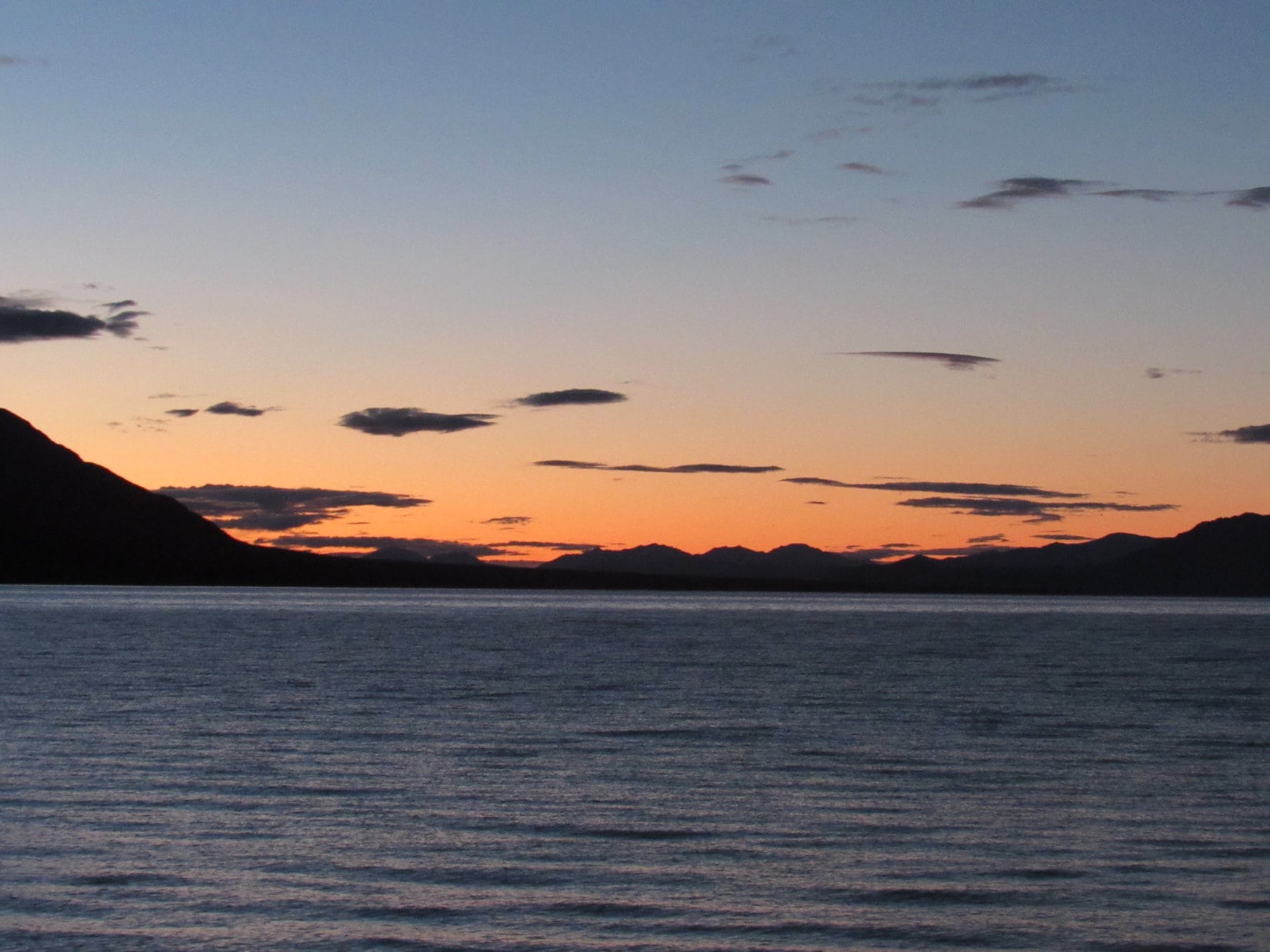
Lupe was more than 500 miles from Palmer, Alaska now. She’d made her 450 miles for the day from where she’d left Gunsight Mountain this morning, so it was time to stop for the night. As the light of day faded much earlier than it had only 3.5 weeks ago, Lupe got to spend time playing and sniffing around the S shore of Kluane Lake once more.
Lupe at the S shore of Kluane Lake. Photo looks W.
Sheep Mountain from Kluane Lake. Photo looks NW.Kluane LakeLupe spent the rest of the evening playing and sniffing around the S shore.A dramatic sky near evening’s end.
One thing hadn’t changed. Beyond Kluane Lake, a line of mountains marched endlessly away to the N horizon toward the Arctic. The remote peaks were part of a vast wilderness only a little less mysterious than before, and as beautiful and romantic as ever.
Start 8:23 AM, 50°F, USFS Road No. 203.5 just off Rochford Road
Lupe liked the looks of this place – green grass, a bubbling creek, choice of sun or shade. A slice of American Dingo paradise, that’s what it was! Loopster was all smiles.
Lupe was all smiles at the start of Expedition No. 203. She anticipated a great day ahead!
Smiles and energy, that is! Lupe took off running. She bounded through the tall grass wet with dew near Gimlet Creek. Of course, she tested the waters of the creek itself, too. They quickly earned the Carolina Dog seal of approval.
Lupe’s day started close to the confluence of Gimlet Creek & East Gimlet Creek. Here she tests the waters of East Gimlet Creek.
As SPHP started up USFS Road No. 203.5, Lupe raced through fields on both sides of the creek. Sometimes she scrambled partway up the sides of the valley. She was looking for squirrels, but didn’t find any. A great many of the large trees on the hillsides were dead, killed by pine bark beetles.
Lupe remained hopeful, though. The day was just beginning. Having a creek to follow was simply glorious! Loop loved being able to cool off in the stream. At intervals, the road had big mud puddles, too. Lupe strolled through each one, slurping up cloudy brown water as she went. She was definitely getting her mineral requirements met.
Lupe on USFS Road No. 203.5 in lower Gimlet Creek valley. Photo looks N.Lupe got to follow USFS Road No. 203.5 up Gimlet Creek valley for more than 2 miles. Actually, it was SPHP who followed the road. Loop was busy exploring.Looking downstream in the Gimlet Creek valley. The lower part of the valley was fairly narrow as seen here. Photo looks S.Looking NNW up the valley.
Only a week ago, Lupe had found snow up in the hills on Expedition No. 202. No chance of that today. Not even close. Beneath a cloudless blue sky, the day was warming up fast. In fact, the forecast was for near record temperatures in the 80’s °F. From winter to summer with scarcely any transition between. Not good, but not that unusual in the Black Hills.
After 2 miles, the road forded Gimlet Creek. Lupe was already slowing down due to the rising temperatures. She stayed closer to SPHP and the road. Fur coats are wonderful when it’s cool out, but not so great when it’s warm. Lupe’s tongue hung out. She wore a perpetual smile whether she wanted to or not.
By the time Lupe reached the Gimlet Creek ford on USFS Road No. 203.5, she was slowing down. The day was warming up fast, and the heat was starting to get to her. The creek and every mud puddle she came to were welcome sights.
Beyond the ford, the valley widened out considerably.
The valley had become much wider by the time Lupe reached the ford on Gimlet Creek. Photo looks N across the valley, which curves to the E (R) here for a short distance.
About 0.25 mile N of the ford, Gimlet Creek turned E. From a side valley to the W, a smaller tributary stream flowed into a pond before continuing over to its confluence with Gimlet Creek. Several ducks flew away as Lupe drew near the pond.
Getting close to the pond, which isn’t in view quite yet, but isn’t far off to the L. The small tributary stream flows through the fenced-in area seen above Looper on its way to Gimlet Creek on the far R. Photo looks NE.Lupe reaches the pond, the biggest water feature she would see on Expedition No. 203. Several ducks had flown off as Lupe approached. Photo looks NW.A good bridge crossed the small tributary of Gimlet Creek where it exited the pond. Lupe had come up USFS Road No. 203.5 from the direction seen on the L. Photo looks SW.
A family of Canadian geese had made this pond home. When Lupe arrived, they were out for a stroll on the green grass nearby.
Momma and papa goose out for a stroll with their 5 chicks.
The little geese were far too young to fly, so when momma and papa saw Lupe, they led the chicks back to the safety of the water. In the meantime, the ducks had already returned.
By the time Lupe circled around to the N side of the pond, the ducks had already returned. Photo looks S down the Gimlet Creek valley the way Lupe had come.The geese returned to the safety of the water while Lupe was around.
For a few minutes, Lupe and SPHP enjoyed watching the ducks and geese. Unseen frogs sang a noisy tune. It was a pleasant scene, but Lupe was soon eager to press on.
Immediately N of the pond, USFS Road No. 203.5 left the valley and disappeared up a forested hillside. Lupe didn’t follow it. Instead, she went W on a fading side road, which paralleled the tributary of Gimlet Creek. She had to go around deadfall timber blocking the road in a number of places.
The side road soon ended at a marshy area where another small valley came down from the N. Lupe crossed the marsh, still heading W. She stayed in the valley the tributary of Gimlet Creek flowed through. Eventually this valley turned N, too.
The tributary of Gimlet Creek was a very small stream, but did have flow. After the valley turned N, Lupe came across another minor road following this stream. The road forded the tiny creek 5 or 6 times. Lupe was always glad to have another chance to cool her paws off.
A minor road Lupe was following upstream forded the little creek 5 or 6 times. Lupe was always glad to have another chance to cool her paws off or get a quick drink. Photo looks NNE.The tiny stream supported a lush green ribbon of life.
Lupe was 1.25 miles from the pond when she came to a pole fence across the valley. On the other side was a better road. Lupe went around the fence and continued N on this new road. She met a little green snake basking in the sun. Though it was warm out, the snake didn’t move even when SPHP prodded it with a stick.
Why the snake didn’t move wasn’t clear. It looked fine, but perhaps something was wrong with it? The only sign of life it gave was to flicker its tongue when lightly poked.
Lupe came to this small green snake basking in the sun on the road. It wouldn’t move other than to flick its tongue now and then.
The new road quickly brought Lupe to a junction. A sign said Lupe had been on Killoern Springs Road (USFS Road No. 204.1B). The other road at the junction was USFS Road No. 204.1. Lupe sat in the shade of a big pine tree while SPHP checked the maps.
Lupe relaxes in the shade of a pine tree while SPHP checks the maps.Looking NW from the junction of Killoern Springs Road and USFS Road No. 204.1. Pine bark beetle damaged sections of the forest are a common sight in the Black Hills these days.
The maps confirmed that Lupe was now more than 3 miles from where she’d left the G6. She actually did have a peakbagging goal today. She was on her way to Minnesota Ridge(6,240 ft.), the summit of which was still another 2 miles to the NW. Only a little farther N on No. 204.1 was another junction, this one with Minnesota Ridge Road (USFS Road No. 203). In fact, Lupe could see the junction from here.
Minnesota Ridge Road wouldn’t take Lupe all the way to the summit, but it would get her reasonably close. Lupe headed for it.
The march up Minnesota Ridge Road was sunny. The day was very hot for early May. The little stream Lupe had been following had completely disappeared. Lupe panted. Her tongue hung out as she plodded along the dusty road behind SPHP. A couple of times, SPHP stopped to give her water.
The road didn’t climb all that steeply, but it was steep enough. The heat sapped both Lupe’s and SPHP’s energy. A mile from the last junction, the road finally began to level out. Lupe reached another intersection with Greens Gulch Loop.
The road leveled out about the time Lupe reached this intersection with Greens Gulch Loop (unseen to the L). Photo looks N.
SPHP checked the maps again. Lupe could go either way, W on Greens Gulch Loop or N on Minnesota Ridge Road. No matter which way she went, she would have to leave the road before long.
Loop stayed on Minnesota Ridge Road for another 0.25 mile. She reached a big mud hole where frogs were singing noisily.
Frogs singing in this mud hole on the E side of Minnesota Ridge Road ceased their din when Lupe appeared. Lupe was far enough N now. It was time to leave the road to look for the summit of Minnesota Ridge. Photo looks ENE.
Lupe left the road heading WNW through the forest. The true summit of Minnesota Ridge might be as much as 0.5 mile away or even a little more. SPHP was more concerned with how difficult it might be to find the summit, than how far away it was. The topo map showed only a gradual rise in the terrain toward the W. The top of Minnesota Ridge was likely to be flat, forested, and cover a lot of territory.
Although many trees were still green and growing, the forest floor was thick with beetle-killed deadfall timber. Lupe wound around trying to avoid the worst of it. At least it was clear Lupe actually was gradually gaining elevation as she continued WNW. Nothing except more forest was in view in any direction.
After a long wandering way, Lupe started catching glimpses of distant ridges miles away to the W. She was nearing the W edge of Minnesota Ridge, which was the steepest side of the mountain. As she reached what seemed to be the highest terrain, Lupe found a series of boulders scattered along a line running roughly N/S.
Tree broken views of distant ridges farther W appeared as Lupe reached the W “edge” of Minnesota Ridge. A line of boulders ran N/S. Maybe one of them was the true summit? Photo looks W.
Lupe had hardly seen any rocks in the forest until now. Maybe this was Minnesota Ridge’s summit area? It seemed likely. Perhaps one of these boulders would be clearly higher than all the others? Maybe it wasn’t going to be as hard to find the true summit as SPHP expected.
Lupe explored S along the line of boulders. She didn’t have to go too far before it became clear the terrain was definitely going to start dropping off if she went any farther this way.
Lupe on the last big boulder at the S end of the highest terrain. A short exploration to the S from here confirmed that Lupe would lose elevation going any farther that way. Photo looks S.
Once it was established that there was no point in going any farther S, Lupe turned N again. She followed the line of scattered boulders looking for the highest one.
Lupe willingly leapt up on each boulder SPHP thought might be the true summit of Minnesota Ridge(6,240 ft.), but the process soon became somewhat of a comedy. Each time SPHP believed Lupe had been at the true summit, another boulder that seemed clearly a little higher would be found hidden in the forest another 20 to 50 feet farther N.
Lupe on the 1st boulder SPHP declared the true summit. Photo looks NE.On the 2nd “true summit”. Photo looks NW.On the 3rd “true summit”. Photo looks E.Lupe on the 4th “true summit”. This one was well back from the W edge of the mountain, and had an interesting knob of different colored rock firmly fastened on top. There was even a clearing in the forest nearby. Photo looks NW.The 5th “true summit” rock had its own little ecosystem growing on it. SPHP named this one Garden Rock. Photo looks ENE.Looper on the 6th “true summit”, the highest and farthest N in the line of boulders. Photo looks NNW.
Finally after standing on 6 different “true summit” boulders, the line of boulders faded away. The ground to the N seemed to dip slightly, so No. 6 was probably it. To be certain, though, Lupe continued N near the W edge of the mountain. Only when it was clear that the terrain was going to start dropping off decisively would Lupe claim her peakbagging success.
It didn’t happen. Beyond the slight dip, the ground rose slowly again. Lupe went hundreds of feet N before coming to another area where the terrain leveled out. She was almost certainly higher now than she had been back at boulder No. 6. This large area of flat ground was sunny and open. Most of the trees had been killed by pine bark beetles, and had subsequently snapped and fallen over.
SPHP didn’t like it. This area now had to be considered the true summit, but the place lacked charm. All the deadfall was just plain ugly. A couple of modest-sized rocks about equal in elevation were now joint contenders for true summit. Once again, Lupe willingly got on each one.
Boulder No. 7 in contention for the title of true summit. However, No. 8 only 25 feet away was about the same elevation, too. Photo looks SSW.“True summit” No. 8 was in an ugly place with lots of deadfall. Photo looks N.
“True summits” 7 and 8 were in such a hideous place, there was no point in lingering. The terrain to the N was still flat, so Lupe needed to explore it too, in order to make certain this was actually the top of the mountain.
The deadfall was bad for hundreds of feet. Lupe and SPHP made slow progress, but nearing the end of it, a rock ledge appeared ahead. It was definitely at least 5 feet higher than anywhere Lupe had been yet! SPHP was glad. Lupe worked her way over to it.
From the S end of the rock ledge, Lupe could see that the ledge continued on to the NNW for some distance. Lupe was at the top of a line of small cliffs which became larger off to the NNW, but only because the terrain below the cliffs was dropping off faster than the ledge above. The S end of the ledge where Lupe first reached it appeared to be the highest point.
The rock ledge definitely made a better looking “true summit” No. 9. Lupe perched on top while SPHP scrambled down through rocks and deadfall to get her official Minnesota Ridge(6,240 ft.) summit photo.
Lupe perches on “true summit” No. 9 at the S end of the rock ledge. Photo looks N.
Lupe even enjoyed a bit of a view from the ledge, making it even more worthy of being the summit.
The view to the W wasn’t spectacular, but was much better than a bunch of collapsed dead trees.
Lupe and SPHP explored a little farther to the NNW along the rock ledge. The ledge lost elevation gradually in this direction, but continued onward.
Beneath the shade of a big pine tree, not far from “true summit” No. 9 at a point where the views to the W were pretty good, Lupe and SPHP took a break. Lupe crunched some of her Taste of the Wild. SPHP munched an apple. The water in the water bottles was icky warm now, but that couldn’t be helped. Warm water or none at all. Take it or leave it.
After 5 or 10 minutes, a couple of large birds came sailing by. They circled and soared in updrafts near the ledge. They circled around many times, but were moving so fast through the small patch of sky where Lupe had a clear view of them between the pines, it was hard for SPHP to get a good photo.
One of the two large birds soaring on updrafts near the long ledge. The birds circled around to swoop by many times during Lupe’s break.Hawks or eagles? SPHP wasn’t sure. They didn’t seem quite large enough to be eagles.Lupe on a big rectangular rock at the edge of the ledge. Her break area was just off to the L. True summit No. 9 is only a short distance beyond her. Photo looks SSE.On the same rectangular rock.
When the big birds soared away for the final time, Lupe’s break was over. She returned briefly to “true summit” No. 9. Since the terrain 30 to 50 feet back from the edge of the ledge seemed to be slightly higher, Lupe resumed her search for the absolutely highest point.
Nothing really stood out as being the exact spot, so Lupe chose a small rock that looked as high as anything else around for her final “true summit” No. 10 photo. If this wasn’t the real deal, SPHP was convinced it had to be within a foot or two of the actual high point, which might be hidden anywhere among all the deadfall nearby. This was close enough as far as Carolina Dogs are concerned!
True summit No. 10. Even if this wasn’t the actual tippy top of Minnesota Ridge it had to be close. Certainly close enough as far as Carolina Dogs are concerned. Photo looks NNE.
Ten true summits were more than enough for any mountain. Lupe claimed her peakbagging success. Now what? The sun was still high in the sky. Hours and hours of daylight remained. May as well explore NNW along the rock ledge to see how far it went. Maybe there were places with better views than Lupe had seen so far?
Lupe explores farther NNW along the rock ledge. Photo looks SSE.
Lupe did come to a few places where the rock ledge provided better views! All of the views were to the W where Lupe could see the edge of the higher limestone plateau country of the western Black Hills. She could see Nipple Butte(6,800 ft.), Flag Mountain(6,937 ft.) and other high points she had been to before on prior expeditions, but they were all miles away.
Looking SW from the ledge toward the higher limestone plateau country of the western Black Hills.Lupe out on the largest rock platform she found along the entire ledge. Nipple Butte and Flag Mountain are in view on the horizon straight up from her, but they are very far away. Photo looks SW.
The rock ledge eventually petered out. The views were gone. It was clear Lupe really had been to the summit. She had lost enough elevation by now so there was no doubt. With all the time left in the day, Lupe could still do some exploring.
Years ago, back during the days of her early expeditions, Lupe had come to the Minnesota Ridge area on several different occasions, although she had never sought out the summit before today. Somewhere to the W was a road she had followed as a very young Dingo a couple of different times. It would be fun to travel it again. Somewhere to the N was a road she had been on before that would lead her to it.
Lupe and SPHP went N looking for the road. Lupe was losing elevation steadily now. She came to a big field that didn’t seem familiar.
Lupe came to this big field somewhere on the N slope of Minnesota Ridge. SPHP didn’t recognize it. Photo looks S.
The big field led down to another good-sized field, where Lupe discovered an American Dingo display stand.
Lupe on the American Dingo display stand. What else could it be?
From the American Dingo display stand, Lupe headed NW. She picked up a faint road she had never been on before. Eventually it turned W and led her to the USFS road SPHP remembered W of Minnesota Ridge.
Lupe traveled S on this road, which ultimately proved to be USFS Road No. 204.1A. It was fun to recognize a few places along the way. Lupe took a short break at a tiny creek she had been to years before. This creek flows down into Greens Gulch, but Lupe did not follow it as she had done on one prior occasion.
Lupe drank again from this tiny stream that flows into Greens Gulch. It had been years since she’d last been here.
The road went up and down. It was surprising how much of it still seemed familiar, despite the years gone by. The uphill stretches weren’t that long or difficult, but made the heat more oppressive. Lupe had plenty of time. After climbing past one uphill stretch, Lupe and SPHP took a water break.
Yes, the water was warm, but it did feel good to sit down and rest a bit. A few clouds were drifting through the blue sky. Lupe seemed content to lay panting on the ground, watching and listening. Why not? SPHP stretched out, too. The heat made being lazy easy.
SPHP watched clouds. Lupe listened to birds and watched for signs of activity in the forest. Half an hour went by. Then Lupe spotted a deer peering at her through the forest. For a couple of minutes, Lupe and the deer stared at each other. When the deer finally looked away and started moving, it was too much for Lupe. Instinct took over and she was off like a shot. A minute later she was back. Lazy day break time was over.
Lupe’s trek along the road continued. She soon came to a familiar intersection where she turned E on USFS Road No. 204.1. She completed her big loop around the W side of Minnesota Ridge and arrived back at Killoern Springs Road.
On the remaining 3 miles back to the G6, Lupe retraced her route taken earlier in the day. The ducks and Canadian geese were still at the pond. Lupe and SPHP stopped to watch them for 15 minutes before pressing on S down Gimlet Creek valley.
Nearing the pond again. Photo looks E.The Canadian geese were still at the pond. Lupe and SPHP watched them for a little while before pressing on.
The G6 wasn’t far from the confluence of Gimlet Creek and East Gimlet Creek. On her last exploration of the day, Lupe visited the confluence. She drank the refreshing cold water, and cooled her paws off one more time in the combined stream.
Expedition No. 203 had been different from most in recent years. It was more of a throwback to the long treks of Lupe’s early years, with less emphasis on peakbagging. Lupe had really enjoyed Gimlet Creek, the pond, and the easy strolls through the long valleys. She still made it to the top of Minnesota Ridge, and got to see territory she hadn’t been to in years.
The unseasonal heat showed one thing, though. It was soon time to think about heading to higher ground and cooler climes. For a little while yet, that still meant higher terrain in Lupe’s Black Hills. However, it wouldn’t be long before more distant adventures beckoned.
The start of Lupe’s grand summer of 2017 was fast approaching.
(End 6:04 PM, 77°F)
At the confluence of East Gimlet Creek (L) and Gimlet Creek (R) at the end of the day.


 E of Tok, Lupe crossed the Tanana River. She was happy to get out of the G6 to stretch her legs a bit.


 Lupe left Alaska, returning to Yukon Territory in Canada around 2 PM Alaska Time (3 PM Pacific Time). Soon she was seeing bigger mountains closer by again. She crossed the White River without stopping. A few weeks earlier, it had been wide and impressive, but now it was mostly dried up.

 By the time Lupe reached the Donjek River, it was getting to be late afternoon. The Donjek was running low, too, but it seemed like a good time to get out of the G6 to stretch and walk around a bit. Lupe went for short walks on both sides of the scenic river, spending about 45 minutes in the area.


 In Kluane National Park, Lupe and SPHP stopped again at the Tachal Dahl visitor center in the Slims River valley at the S end of Kluane Lake. The visitor center was closed. Not a soul was around. SPHP made use of one of the picnic tables to prepare dinner. Lupe was eager to help SPHP make the last can of beef stew and remaining cheese disappear, but she buried a cracker with her nose.