Day 5 of Lupe’s 2018 Dingo Vacation to the Bighorn Mountains of Wyoming & Beyond!
Oh, this was going to be a cinch! USFS Road No. 10 had been rough, but the G6 had made it. SPHP parked near the road’s highest point. (11:33 AM, 53°F) When Lupe hopped out, she was at 10,000 feet elevation. She could already see Cloud Peak(13,167 ft.), mightiest of the Bighorn Range, far to the SE.
Hunt Mountain(10,162 ft.), the American Dingo’s immediate peakbagging objective, was only 0.67 mile W of the road. From this direction, a traipse up a gradual, treeless slope to the summit was mere child’s play. Good thing, too. After yesterday’s long march to Dry Fork Ridge and back, SPHP was, well, call it “low energy” today.
Hunt Mountain as seen from USFS Road No. 10 about 3 or 4 miles S of Highway 14A on the way to Lupe’s departure point. Photo looks SW.Cloud Peak (Center) from close to where the G6 was parked along USFS Road No. 10. Photo looks SE with considerable assistance from the telephoto lens.
A 10 to 15 mph W breeze was blowing as Loopster set out for a small rock outcropping visible a short distance W of the road.
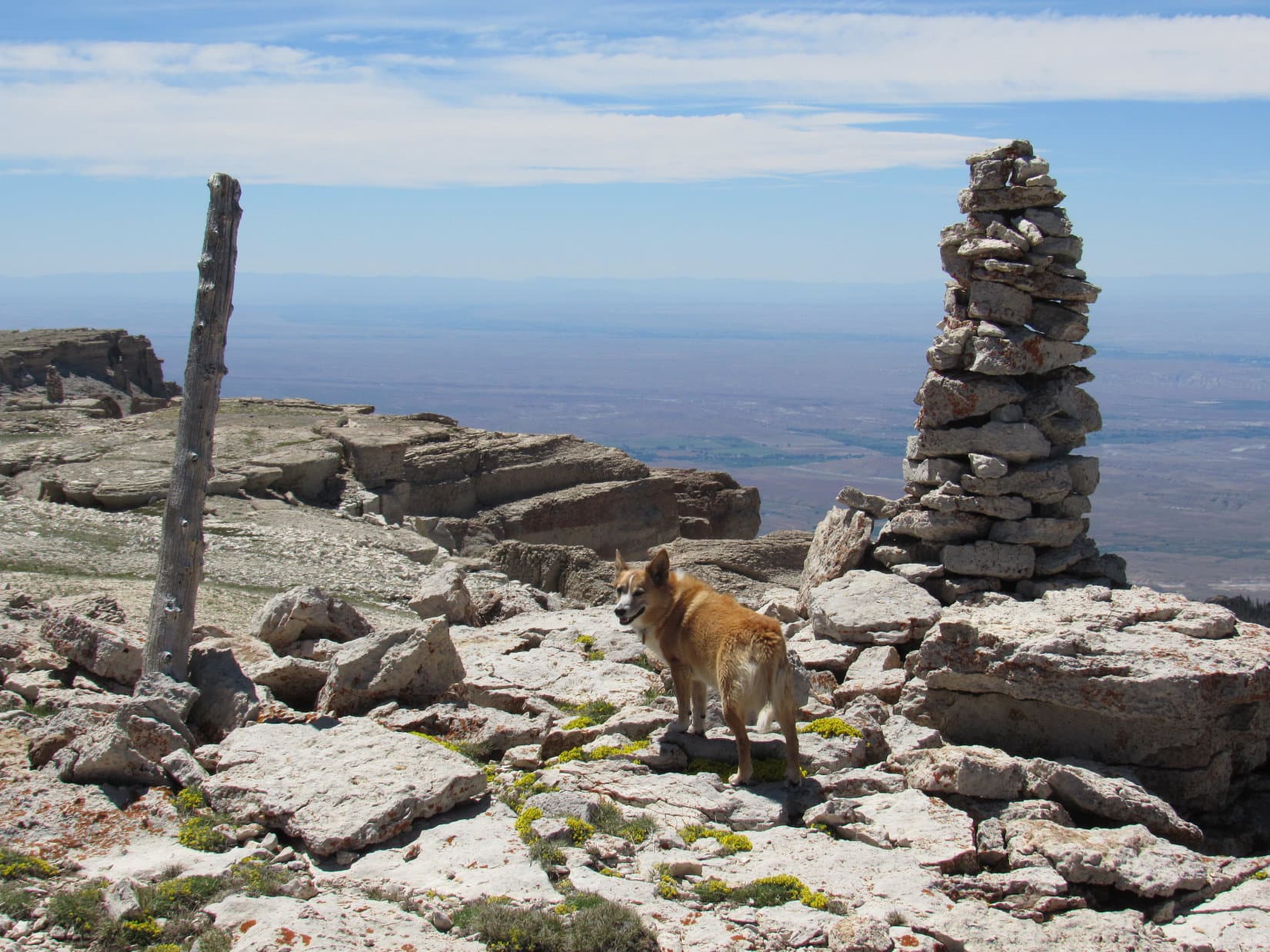
Hunt Mountain from the small rock outcropping. Photo looks W.
From the rocks, a broad drainage area at the base of a big snowdrift was seen sloping gently to the NE. In order to avoid any wet terrain, Lupe turned SW gaining elevation slowly. Following the high ground, a big arc could be made around to the NW when she got closer to the W edge of Hunt Mountain.
Lupe delighted in frolicking on a snowbank she found in a depression.
Lupe enjoys a refreshing moment on the snowbank she discovered in this depression. Cloud Peak (L) is on the horizon. Photo looks SSE.
The W face of Hunt Mountain drops off very sharply. As Lupe got close to the edge, she found fortification-like rock formations standing along the brink of a line of cliffs.
Fortification-like rock formations stood perched along the W edge of Hunt Mountain. Photo looks WNW.Near the W edge of Hunt Mountain. Photo looks SSW towards High Point 10,015.
The summit of Hunt Mountain was still a little farther NNW. Traveling toward it, Lupe could soon see a tall cairn ahead.
Traveling NNW along the W edge of Hunt Mountain a tall cairn (R) came into view. Photo looks NNW.Getting closer. Photo looks NW.
The tall cairn had a commanding view of a huge amount of territory W of the Bighorn Range. However, upon reaching it, Lupe could see that this first cairn was not at the top of Hunt Mountain. Another higher cairn was in sight farther N.
The tall cairn had a commanding view of a vast territory W of the Bighorn Range. Photo looks SW.From the first cairn, a second, higher cairn (R) could be seen. Photo looks N.
Approaching the second cairn, Lupe came upon a sinkhole. Apparently parts of Hunt Mountain were hollow!
Loop discovers a sinkhole S of the 2nd cairn. Photo looks N.
The second cairn proved to be the summit of Hunt Mountain(10,162 ft.). With nothing to obstruct the views in any direction, Lupe enjoyed magnificent scenery everywhere she looked.
At the summit. Photo looks SW.A wider view of the summit area looking WSW.Looking WNW with help from the telephoto lens.Looking N.Bald Mountain(10,042 ft.) is L of the cairn. Duncum Mountain(9,831 ft.) is on the horizon at Center. Photo looks NNW.Cloud Peak(13,167 ft.) (Center). Photo looks SE.Black Tooth Mountain(13,005 ft.) (L) and Cloud Peak (Center) with lots of help from the telephoto lens. Photo looks SE.
The view to the NW was of particular interest. Lupe could see Bald Mountain(10,042 ft.) and more distant Medicine Mountain(9.962 ft.), both of which she had been to before. In fact, she intended to visit Bald Mountain again later on today.
At the summit of Hunt Mountain. Medicine Mountain (Center) is on the far horizon. Bald Mountain (R) streaked with long snowbanks is a bit closer. Photo looks NW.Bald Mountain with help from the telephoto lens. Lupe intended to make her 5th ascent of Bald Mountain later this afternoon. Photo looks NW.Medicine Mountain (R). The white sphere is part of an FAA installation. Medicine Mountain is the site of the Bighorn Medicine Wheel. Photo looks NW with help from the telephoto lens.
Although sparse vegetation gave Hunt Mountain an overall barren look, tiny wildflowers decorated the summit. Orange lichens grew on many of the whitish stones. A knob of stone nearly as high as the summit stood close by to the N. Just for fun, Lupe got up on top of it, too.
The overall rather barren appearance of Hunt Mountain was deceiving. Tiny wildflowers flourished among the rocks.Pink flowers were fairly uncommon. Blue and yellow ones were predominant.These yellow flowers grew on a knob of rock N of the summit that had a particularly nice display of orange lichens, too. Medicine Mountain (Center) & Bald Mountain (R) are on the horizon. Photo looks NW.Lupe by the yellow flowers on the N knob of rock. Medicine Mountain (L) and Bald Mountain (R) both in view. Photo looks NW with help from the telephoto lens.
In addition to the second tall cairn, Lupe found two survey markers on top of Hunt Mountain. Both were stamped “Hudson” and had arrows that pointed toward a pile of rocks between them.
Lupe stands near the first of the survey markers she came to, Hudson No. 2. Photo looks NW.Hudson No. 2.Hudson No. 1.
Hunt Mountain offered an awful lot of scenic bang for the amount of effort required to get here! However, it was rather breezy at the summit. After taking in the sights, Lupe and SPHP retreated down the slope E of the summit to escape the W wind.
Lupe went as far as a rim of rocks overlooking the big snowbank that had been visible from the first little rock outcropping she had come to after leaving the road. A big boulder on the rim provided some shade. Low on water, SPHP packed a couple of water bottles and a jug with snow, setting them out in the sun so the snow would melt.
Loop near the big boulder while waiting for the sun to melt snow packed into the water containers. Photo looks SW.
Lupe and SPHP rested by the big boulder, relaxing while waiting for the snow to melt. Weary from yesterday’s exertions, Looper put her head down and fell fast asleep. Soon SPHP was out of it, too.
When SPHP came to, Lupe was gone! A squeaking noise. Marmots! SPHP scanned the rocky rim of the ridge. There she was! The Carolina Dog had snuck off to go looking for marmots among the rocks. SPHP called her back. She returned marmotless, but evidently enthused and entertained by her futile hunt for them. This was, after all, “Hunt” Mountain.
SPHP packed more snow into the water containers. Better not fall asleep this time, no matter how tempting it was. SPHP started writing in the trip journal. Looper got bored, and passed out again. Time ebbed away.
Suddenly, a distant pop followed by a closer one. What the? Within a minute, another couple of pops. Same deal, except the second pop was much closer. Gunfire! Lupe was awake and concerned. Someone was using the boulder she was resting beside for target practice! Ordering Loop to stay down, SPHP stood up displaying a red shirt and waved.
At first, SPHP didn’t see anyone, but a pickup truck was now in view off to the E parked close to the G6. Oh, yeah. There he was! Off to the SW, someone carrying a rifle was heading for the W edge of Hunt Mountain, but well S of the summit.
Hmm. Maybe enough snow had melted? The gunfire made a convincing case. SPHP gathered the water bottles up. Lupe returned to the summit of Hunt Mountain for a final look around before heading back to the G6. On the way down, whoever it was with the rifle was seen far to the S on a rock platform along the W edge of the mountain. The rifle was now set up on a tripod.
No further incidents occurred. An easy downhill stroll, and Loop was back at the G6. (3:10 PM, 59°F) SPHP drove off, conceding the rifleman complete possession of Hunt Mountain. Too much hunting going on at Hunt Mountain for SPHP’s tastes. The American Dingo was done here, anyway. On to Bald Mountain (10,042 ft.)!
Once back down to Highway 14A, SPHP turned L (W). 9 or 10 miles later came another L turn into the Bald Mountain campground. SPHP parked the G6 at the S end of the campground road. (4:24 PM, 66°F)
Loop left the campground heading SE. Bald Mountain was dead ahead. This would be her 5th ascent! Like at Hunt Mountain, there was nothing to climbing Bald Mountain. Bald Mountain is just a big, rounded hill. This was going to be harder, though. The summit was 2 miles away, and the Carolina Dog would have to gain nearly 1,000 feet of elevation.
Loopster sets off on her 5th ascent of Bald Mountain (L). Photo looks SE.
A big stand of pines stood S of the most direct route up Bald Mountain. Lupe would like the woods, so SPHP headed for it. Loop crossed a small creek. The ground near the forest turned out to be wet, much boggier than SPHP had anticipated. Yellow wildflowers grew in profusion.
Crossing a small creek on the way to the forest.Yellow wildflowers were abundant in and near the boggy forest.
The Carolina Dog did have fun exploring the boggy woods. Lupe found a squirrel to bark at, a surefire source of Dingo happiness. SPHP enjoyed being out of the wind, but it didn’t last. The forest encompassed only a small area. Soon Looper was through it. The ascent of Bald Mountain began in earnest.
The climb was the same relentless uphill trudge as always, but seemed harder. Low energy SPHP was just plain tired from the start. Loopster didn’t like the W wind, which blew harder as she gained elevation. The treeless slope offered absolutely no refuge. By the time Lupe made it to top of the W end of the mountain, the wind was 20 to 25 mph.
There was a reason Lupe was on Bald Mountain for a 5th time. In addition to tagging the summit, SPHP wanted to fix the names. In this wind, the American Dingo wasn’t too keen on either idea. SPHP had success finding the names fairly quickly, but Lupe was not happy about having to wait around for 20 minutes while SPHP repaired them.
Loopster sits next to her name after SPHP repaired it. Hunt Mountain is in the distance directly behind her. The summit of Bald Mountain is on the L. Photo looks SE.
Loop was even more disgusted when SPHP made it clear that going on to the summit was a requirement. She soon resigned herself to the idea of this wind tunnel trek, however, and led the way. It wasn’t so bad. Why, this gale was going to blow her clear to the top!
Loop, resigned to having to go all the way to the summit, leaves SPHP behind. Photo looks SE.
A 30 mph gale swept over the summit of Bald Mountain(10,042 ft.). A birdhouse stood NW of a survey marker. Little blue, yellow, and white wildflowers blanketed the ground. Not a bush or a tree anywhere.
A great view of Hunt Mountain(10,162 ft.), where Lupe had just come from, was off to the SE. Medicine Mountain(9,962 ft.) was only 4 miles NW, while Duncum Mountain(9,831 ft.) was farther N. Unfortunately, lingering to contemplate the fine views wasn’t going to happen under these conditions. Lupe stood bravely in the breeze hoping SPHP would just hurry up.
Lupe reaches the top of Bald Mountain to claim her 5th successful ascent. Duncum Mountain (Center) is on the horizon. Photo looks N.Loop by the survey benchmark. The W end of Bald Mountain is beyond her with Medicine Mountain (Center) 4 miles away in the distance. Photo looks NW.The survey benchmark.Duncum Mountain (L of Center) again. Photo looks N.Looking SW.Hunt Mountain (L) and High Point 10,015 (straight up from the pipe). Photo looks SE.Hunt Mountain (Center). Photo looks SE with help from the telephoto lens.
Loopster was thrilled when SPHP indicated it was finally time to head down. The wind made her wild, and she really took the lead now. Lupe raced here and there roaming a vast plain despite the gale. She passed by her name again, then paused at the W end of Bald Mountain before the steepest part of the descent.
Looper takes the lead on the way down Bald Mountain. Medicine Mountain (Center) in the distance. Photo looks NW.Approaching the steepest part of the descent. Medicine Mountain (Center). The road to the Bald Mountain campground is near the R edge. Photo looks NW.
The feral, ferocious were-puppy attacked SPHP twice. Once down off Bald Mountain, she again prowled the boggy forest. By the end, even the were-puppy was tired and hungry. Immediately upon reaching the G6, she devoured 2/3 of a can of Alpo. (7:25 PM, 61°F)
N of Bald Mountain late in the day. Photo looks S.
A couple miles N of Highway 14A, SPHP found a dispersed camping spot off USFS Road No. 11 near the edge of the forest. The sun sank below the horizon. Hunt Mountain and Bald Mountain weren’t difficult peaks, but the fabulous scenery and fresh air had been enough for this day.
In any case, the sandman was coming. The wild one curled up, and heaved a bleary-eyed sigh. SPHP drew her blankie over her. Moments later, magically re-energized, the were-puppy bounded off to new adventures in the mountains of Dingo dreamland. Perhaps the restless breeze blew there tonight, too?
In the wild W wind atop Bald Mountain, Bighorn Range, Wyoming 6-13-18
Notes:
Hunt Mountain directions: In the northern Bighorns, go W from Burgess Junction on Hwy 14A approximately 14 miles to a L (S) turn onto USFS Road No. 10. Follow No. 10 about 5 miles to the highest part of the road. Hunt Mountain is 0.67 mile E.
Bald Mountain directions: Go approximately 24 miles W of Burgess Junction on Hwy 14A (10 miles beyond the turn to Hunt Mountain). Take a L (S) turn into the Bald Mountain campground. Bald Mountain is 2 miles SE.
Day 4 of Lupe’s 2018 Dingo Vacation to the Bighorn Mountains of Wyoming & Beyond!
This was it, about as close as the G6 was going to get. SPHP parked near the intersection of USFS Roads No. 168 & 149. Lupe had a long trek, a good 5 or 6 miles down Dry Fork canyon ahead of her. At least the view was encouraging. What could be seen of Dry Fork Ridge(8,480 ft.) looked climbable.
How hard it might be to find the true summit once Lupe got up on the huge ridge was another matter. The top of the mountain appeared to be densely forested. The Carolina Dog might be in for quite an ordeal before she could claim a successful ascent of Sheridan County, Wyoming’s most prominent peak.
Lupe wasn’t worried in the least. She eagerly set off down USFS Road No. 149 (Lower Dry Fork Road) under blue skies, a 15 to 20 mph NW breeze in her face. (9:39 AM, 51°F)
Loop ready to set off down Dry Fork canyon on USFS Road No. 149. Dry Fork Ridge is the forested hill on the R. Photo looks NW.
A miles long mostly downhill trek was certainly an unusual start for a peakbagging quest. Loop cheerily trotted ahead of SPHP making rapid progress. USFS Road No. 149 wasn’t steep, but she was losing elevation at a steady clip.
Getting off to a good start. Dry Fork Ridge is just R of Center. The high point seen straight up from Lupe may be Riley Point(8,538 ft.). Photo looks NW.
The journey was scarcely underway when Lupe detected something on the breeze. Suddenly she dashed off into the tall grass SW of the road.
Oh, looky here, SPHP! Someone never made it to Dry Fork Ridge!
The bleached bones of a large animal, likely a cow, rested on a patch of dirt and dead grass. Apparently the skeleton had been here a while. The American Dingo was quite impressed by this find. She sniffed carefully, conducting a thorough investigation before agreeing to press on.
The upper part of the canyon Lupe was entering was all open meadow. However, it didn’t take long to get down to a first stand of tall aspens. The day was bright, sunny, and warming up fast. Some shade would have been nice. Sadly, the aspens weren’t close enough to the road to provide any.
Too bad those aspens aren’t closer! A little shade would have been nice. Photo looks W.
Apparently, Dry Fork canyon wasn’t as dry as advertised. A mile from the start, Lupe came to a creek – a welcome sight. Loop hopped right in to cool her paws off and help herself to a drink.
Dry Fork canyon isn’t as dry as they’d have you believe. Lupe gets a drink and cools her paws off upon reaching a stream.
USFS Road No. 149 forded the creek twice in rapid succession. For a while, Lupe continued to come upon occasional side streams, but less and less frequently the farther she went. None of the fords were deep, usually only inches, and never more than a foot. However, some of the banks were quite muddy. Now and then SPHP had to search for better spots to cross than the road provided.
At the first steam ford. The water wasn’t deep at all, but SPHP crossed back near the trees since the stream bank along the road was so mucky. Photo looks S.
USFS Road No. 149 went on and on. The wind died down. The day grew warm. Unfortunately, the road didn’t follow Dry Fork Creek, or any of the others. The streams all plunged into a deeper part of the canyon, while No. 149 remained on substantially higher ground to the NE.
Back at the start, the road had lost elevation steadily. Now Lupe came to long flat sections, and even some fairly substantial uphill ones. She was still losing net elevation, but only sporadically in chunks.
Getting closer to Dry Fork Ridge (Center). Photo looks N.
Lupe came to lots of sagebrush on the long road trek before eventually reaching sections of pine forest, too. The pines provided shady relief from the blazing sun. Looper and SPHP took occasional short breaks among the trees.
At last, Lupe emerged from a longer stretch of forest. Ahead, a trickling creek crossed the road. Well down a slope to the W was a building. That had to be the Cow Camp by Miller Creek shown on the topo map. To the Carolina Dog’s immense disappointment, not a single cow was in sight.
After emerging from a longer stretch of forest, Lupe finds a tiny stream and a view of an apparently abandoned Cow Camp shown on the topo map. Sadly, not a cow in sight! Photo looks WNW.
The long road hike was finally over. USFS Road No. 149 ended here. No worries. The map showed a Trail No. 428 winding NNE from the Cow Camp up to West Pass, the American Dingo’s next objective en route to Dry Fork Ridge.
No. 428 wasn’t hard to find. Lupe went right to it.
Oh, maybe things are about to get more interesting now than that long dusty road hike! Here’s Trail No. 428 to West Pass. Photo looks ENE.
Time to start climbing! West Pass was 650 feet higher. Close to where Lupe first found it, Trail No. 428 angled N. The Carolina Dog crossed a marshy hillside full of small streams. Beyond the wet area, the trail curved E heading up into a bowl-shaped region.
Trail No. 428 was overgrown and initially hard to follow. Things were easier once SPHP finally realized the route was marked with red, pink or orange flags and ribbons. In any case, there was never any doubt where Trail No. 428 was headed. Lupe soon saw the edge of the big saddle up on the ridgeline to the NNE where West Pass had to be.
Why, that must be West Pass up ahead already! Doesn’t look that far! Photo looks NNE.
Trail No. 428 got steeper, but also easier to discern, as Lupe climbed the last section leading to West Pass. Few trees grew on the hillside. Before she even reached West Pass, Loopster enjoyed some pretty nice views.
On the steeper part of Trail No. 428 approaching West Pass. Photo looks N.West Pass divides Dry Fork Ridge into two giant long sections. Here Loop is almost up to the pass. Photo looks SE. Riley Point is somewhere in this direction, but the true summit of Dry Fork Ridge is in the opposite direction NW of West Pass.Not quite up to West Pass yet. Photo looks SW back down upon the territory Lupe just came through on Trail No. 428. The Miller Creek Cow Camp isn’t in view, but it’s somewhere down close to the center of this photo.
Upon reaching West Pass, Lupe and SPHP were ready for a break. Small trees provided a little shade. It was breezy up here. Lupe appreciated a shirt SPHP placed over her to block the wind.
Loopster takes a break along the SW edge of West Pass.
The true summit of Dry Fork Ridge(8,480 ft.) is more than 1,000 feet higher than West Pass, and was 1.75 miles NW of where Loop took her break. Before Lupe could even start this next climb, she would have to travel NW across West Pass.
Trail No. 428 goes over West Pass, but heading NE to lower ground, not up onto Dry Fork Ridge. So from here on, Loop wasn’t going to have any official trails to follow.
Crossing West Pass would be easy. The huge saddle was all grassland. It looked like Lupe could explore anywhere she wanted to on the way to the forest on the far side.
The SW edge of West Pass from a rock close to where Lupe & SPHP took a short break. Part of Dry Fork Ridge is on the R. Photo looks W.Crossing West Pass Lupe would head for the huge boulder (Center) before climbing up onto Dry Fork Ridge. Photo looks NNW.
Crossing West Pass, Lupe encountered small streams and boggy areas that hadn’t been apparent from a distance. Most of the wetlands were easily avoided. Loop arrived at the edge of the forest on the NW side of West Pass to find a profusion of yellow wildflowers. She had already gained a surprising amount of elevation.
Lupe arrives at the start of the forest on the NW side of West Pass.West Pass from the edge of the forest. Loop had already gained a surprising amount of elevation. Photo looks S.
The steepest part of the climb up onto Dry Fork Ridge now began. At first Lupe was traveling through a tall and relatively dense pine forest. Although there was no official trail, the American Dingo discovered and followed many game trails for short distances. Loop encountered very few rock outcroppings, all of which were quite small.
Up and up! Finally the forest began to thin. The pines were smaller now. Lupe began coming to steep open lanes of narrow meadows. The sunny meadows were full of wildflowers. Looper roamed anywhere she wanted to, but SPHP stayed close to the shade of the trees.
After a long climb through a tall pine forest, Lupe came to steep narrow meadows full of wildflowers. Photo looks N.
On the upper slope nearing the ridgeline, purple wildflowers began to dominate. What a gorgeous place and spectacular display this was!
Amid a spectacular display of mostly purple wildflowers on the upper slope just short of the ridgeline. Photo looks SW.
The terrain began to level out. Lupe reached the ridgeline. She had gained the big majority of the elevation she needed to, but still had as much as 300 feet left to go. The topo map showed that the rest of the climb would be gradual.
The true summit of Dry Fork Ridge was still a mile or more W of here. The big fear was that Loop would encounter a lot of dense forest making the summit difficult to reach or impossible to identify.
Encouragingly, the search for the summit was at least going to start out well. Lupe had reached the ridgeline at a point where a fair amount of open ground existed. A nice lane of open territory led WSW toward higher ground. Perfect! After pausing for a quick look at the views, Lupe and SPHP followed the promising lane higher.
West Pass from the ridgeline. Photo looks SSE.Black Tooth Mountain(13,005 ft.) (L of Center) & Cloud Peak(13,167 ft.) (Center) from the ridgeline. Photo looks SSE with lots of help from the telephoto lens.Following the open lane higher. Photo looks WSW.
The lane along the top of the ridge stayed open for 0.25 mile. The forest was closing in when Lupe came upon an old road. The map showed this as a spur off a 4WD road N of Dry Fork Ridge. Lupe followed it WSW for a little way, though the map showed it would soon end.
The road didn’t end, but was heading too far SW. The American Dingo needed to be going W or NW. Reluctantly, SPHP led Loop off the road. She journeyed WNW through dense forest gaining elevation slowly.
High Point 8464 was supposed to be around here somewhere. Sure enough, the terrain leveled out. Quite a large area was about the same elevation. Not really expecting to ever see it again, SPHP built a small cairn out of white stones at what seemed to be the highest point.
In the dense forest at High Point 8464. Photo looks NW.By the newly constructed cairn (R) at High Point 8464. Photo looks SE.
Still 0.5 mile to go! Plentiful deadfall timber to the NW made the dense forest intimidating. How was Looper ever going to find the true summit of Dry Fork Ridge in this mess? The answer came much sooner than SPHP expected.
A 100 yard march W from the little cairn at High Point 8464 brought Lupe to the edge of the forest! A remnant of a dirt road, probably the same road she had been so recently following, headed NW into a long, wide meadow, precisely the direction Lupe needed to go.
Hah! Totally unexpected, but what a lucky break! This meadow would almost certainly get Lupe very close to the true summit.
We’ve got it made in the shade now! Come on! This meadow should get us mighty close to the top of Dry Fork Ridge! Photo looks NW.
Lupe romped her way through the big meadow. The old road faded completely away, but that didn’t matter at all. Looper could see higher mountains with patches of snow in the distance to the W. To the NE, a couple of openings in the forest granted views clear out to the prairies beyond the Bighorns.
Higher mountains with snow could be seen on the horizon. Photo looks W.
The highest ground was along the NE edge of the meadow. SPHP headed NW staying fairly close to the trees, while Loop roamed at will. The meadow was even longer than it appeared at first. Well before Lupe reached the end of it, she discovered a road going NE into the forest.
A quick reconnaissance revealed that this short road led to another long meadow on the other side of the highest terrain. Excellent! The forested high ground was boxed in by meadows on both sides. After following this second big meadow a little farther NW, Lupe re-entered the forest.
The forest was pretty flat, but continuing NW Lupe was still gaining at least some elevation. After going a little way, the highest ground seemed to be concentrated along an increasingly well defined line. Lupe came to a succession of minor high points that at first blush appeared to be true summit candidates. Each time, though, continuing a bit farther NW led to a slightly higher spot.
The Carolina Dog discovered an outcropping of white rock towering 3 or 4 feet higher than anything else she’d been to so far. Maybe this was the summit? Seemed promising, even likely.
Maybe this is it, SPHP! Lupe discovers an outcropping of white rock 3 or 4 feet higher than anything else she’d come to. Photo looks N.Another view of the potential summit. Photo looks SE.
To rule out any other summit possibilities, Lupe kept going NW. 50 feet farther, she discovered the start of an escarpment, a line of similar white rocks trending NW. The escarpment was only a few feet high, but it did seem like Loop had gained a bit of elevation. This escarpment was likely even higher than the last spot.
Loop followed the escarpment another 10 or 20 feet before getting up on top. Looking back to the SE, a small cairn sat near the very start, almost completely hidden by the forest.
The true summit of Dry Fork Ridge(8,480 ft.)! Lupe had made it!
This has got to be it! Doesn’t it, SPHP? …. Yes, I do believe congratulations are in order, Looper! Photo looks SE.A happy peakbagging Dingo at the summit of Dry Fork Ridge. Photo looks SE.Another look at the summit. This time from the S.The summit cairn wasn’t far from the edge of the forest, only about 10 feet, but was still well hidden. It could most easily be seen from the N. Photo looks N.
The long trek to Dry Fork Ridge had paid off! Time for another break. A better, longer one than before. Lupe concurred. However, not much could be seen from the little summit cairn buried among the trees. Since the edge of the second big meadow was only 10 feet E of the cairn, Lupe and SPHP went there to rest and celebrate her peakbagging success.
From the break spot, Lupe could see a lot of the second big meadow, but Dry Fork Ridge provided only one distant view from this close to the true summit. Far to the NE Loop could see the prairie beyond the Bighorn Range. Nice, but not dazzling.
One item of interest was close by. An old tree stump sat 15 feet from the forest’s edge. The stump was all knobby with root stubs, none of which were very long. This stump seemed like a decent landmark. It rested only 25 feet NE of the summit cairn. There sure wasn’t anything else notable around to help flag the cairn’s position. In a stroke of brilliance, SPHP decided to call this highlight of Dry Fork Ridge the “Iconic Stump”.
Lupe was so thrilled with the Iconic Stump she dozed off as SPHP told her about it. Hmm.
More than half an hour went by before the initial excitement of the Iconic Stump wore off and the Carolina Dog regained consciousness. Looper had recovered to the point where she was capable of posing for photos near the Iconic Stump. No doubt fantastic news for the hordes intent on repeating her Dry Fork Ridge peakbagging feat one day.
Loop at her rest spot. The Dry Fork Ridge summit cairn is 10 feet behind her hidden in the forest. Iconic Stump in the foreground. Photo looks SW.The best view from close to the true summit of Dry Fork Ridge. Photo looks NE.The second big meadow from the Iconic Stump. Photo looks SE.Looking NW from the Iconic Stump.
Lupe had one more task left to do up on Dry Fork Ridge before heading back. To make certain the cairn actually was at the true summit, she journeyed 400 or 500 feet farther NW along the top of the escarpment. The drop off along the SW edge grew from only a few feet back by the cairn to cliffs close to 20 feet high.
Even so, the cairn clearly was the high point. The whole escarpment was gradually losing elevation as Lupe went NW. That trend was accelerating, too. This was far enough. Loop halted on open ground where she could see a long way N. A deer caught her attention. The distant prairie stretching to the horizon in Montana held SPHP’s.
As far NW on Dry Fork Ridge as Lupe went to confirm the cairn actually was at the true summit. Nothing higher this way, that was certain. Photo looks N.
Nearly an hour after arriving, Lupe returned to the hidden summit cairn for the last time. SPHP took a final look around thinking a registry might be present, but found nothing.
Time to start the long journey back. Loop and SPHP began by following the line of slightly lower high points SE until they faded away. Lupe had a great time sniffing and racing through the forest. She reached the first big meadow farther NW than where she had originally left it on the way to the summit.
Lupe passed by the short road she had taken to the second meadow. She explored the length of the first meadow again while SPHP enjoyed the big views. The American Dingo even returned briefly to the little cairn at High Point 8464.
On the return – more fun times in the first big meadow. Photo looks SW.
At the top of the flowery, forested slope leading back down to West Pass, Lupe and SPHP paused. Still a long way to go, but it was going to be a gorgeous evening. A good time all the way.
Before starting the descent in earnest, Lupe scanned the horizon from Dry Fork Ridge a final time. She probably wouldn’t ever be here again. A melancholy thought; a recurring one in remote places far from home.
Looking over the SW edge of West Pass toward the SE portion of Dry Fork Ridge (L). Photo looks SSE.Looking E over West Pass.Purple wildflowers on the upper slope.
This was it. Time to bid farewell to Dry Fork Ridge. Lupe and SPHP were glad she had come. Dry Fork Ridge had been a great day.
Pleasant hours of beauty, solitude, and companionship still ahead. West Pass, Trail No. 428, USFS Road No. 149 – one last chance to experience them all. Big sigh. Puppy, ho! Onward!
Purple wildflowers danced softly on the perfumed breeze as happy Lupe started down the steep slope. (End – 8:40 PM, 47°F)
Directions: From Burgess Junction (intersection of Highways No. 14 & 14A) in the northern Bighorns take USFS Road No. 15 about 5 miles to a R turn onto USFS Road No 168. Follow No. 168 approximately 5 miles. USFS Road No. 149 is on the L.
Day 3 of Lupe’s 2018 Dingo Vacation to the Bighorn Mountains of Wyoming & Beyond!
The night’s dense fog vanished during the wee hours, and the stars had been out. A chilly morning now, but sunlight filtering through the pines held hope that it would be warming up. Lupe sniffed her way along the bank of the North Tongue River at the Burgess Picnic Ground. The river was running high, full from bank to bank.
Oh, it was going to be a truly epic day! As soon as breakfast was done, SPHP had promised Loop was going to return to the Elysian Fields of Puppy Happiness! She had been there once before, nearly 5 years ago. Visions of bright, sunny meadows fragrant with the scent of a million blossoms, warm breezes, puffy white clouds, and a cool, clear running stream filled Lupe’s head. From a rocky hilltop, she had seen enormous green fields full of beautiful black cows.
Paradise! If only SPHP would hurry up!
By the North Tongue River at the Burgess Picnic Ground.
At last SPHP was ready! After a quick drive W to a R turn onto USFS Road No. 15, the road curved E going up a slope. At the top of the slope was a big pullout on the R. SPHP parked the G6. The Carolina Dog hopped out. From a big rock she could see the Elysian Fields off to the W, not even 0.25 mile away. Oh, joy! (9:39 AM, 44°F)
Oh, there they are! The Elysian Fields of Puppy Happiness are just beyond USFS Road No. 15 down by that black car. Come along, if you like! It’s not far. Photo looks W.
Lupe wasted no time. Down the slope, across the road, and she was back in the fabled Elysian Fields of Puppy Happiness!
Lupe returns to the Elysian Fields of Puppy Happiness for the first time since July, 2013. Next stop is the forested hilltop on the L. Photo looks W.
Lupe was thrilled, of course! She raced through the green fields, full of joyous energy, stopping to sniff and explore wherever interesting scents beckoned. She eventually returned to SPHP, who was walking across the fields, with a few questions.
What happened here, SPHP?
Hmm? What do you mean Loop?
Well, it’s all beautiful, but not like I remember it. The sky is clouding up! Where are the puffy white clouds floating in the blue? The W wind is 15 mph and kinda cold. Where are the warm, gentle breezes? The flowers are still here, but there aren’t nearly as many, and they aren’t blooming in such grand profusion. Why aren’t the Elysian Fields of Puppy Happiness as glorious as they used to be?
Oh, I see! Easily explained, Looper. It’s June now, not July like when you were here before. Another month, and the Elysian Fields will return to their former glory. You can count on it! We’re just a bit early. Summer comes late and doesn’t last long up here in the mountains. Paradise isn’t fully in season just yet.
Paradise has seasons?
Yes, indeed! And summer, when it’s all at it’s height of splendor, is the shortest season of all. There’s a reason why most of your Dingo Vacations occur in July and August, you know.
Does that mean winter comes to the Elysian Fields of Puppy Happiness?
Oh, yes. Longer, colder, crueler, and with more snow and ice than you’ve ever experienced!
Well, who knew? They never put that in the brochures, do they?
Oh, come on! You’ve never even seen a brochure about this place. They don’t exist. Silly Dingo!
Lupe was right. It was kind of cool, cloudy and windy. Be that as it may, it wasn’t a bad day to be out in the mountains. The Elysian Fields of Puppy Happiness were still a great place to be, even if not at their height of glory. After crossing the first big field, Lupe carried on, following a trail W along the N bank of the North Tongue River.
The American Dingo soon forgot any complaints. She kept dashing off to explore this and that.
Loop by the North Tongue River. Buildings at the PK Cow Camp (R) are in the distance. Photo looks WSW.
Lupe (Center) exploring below rock formations near the river. Photo looks NW.
A trail ran along the river below small bluffs. Photo looks WSW.
Looking back downstream from one of the bluffs Lupe explored. Photo looks E.
A small tributary of the North Tongue River flows down from the PK Cow Camp. Approaching this stream, SPHP glanced up toward one of the last bluffs to see Lupe frozen at attention. She was staring at the field beyond the creek. Something over there was staring back, too!
Lupe and this bull moose were staring each other down. Photo looks WSW.
The bull moose with lots of help from the telephoto lens.
A bull moose! Loop and the moose stared each other down. Neither flinched. American Dingoes are great starers! Finally, the moose had had enough. He turned slowly around, then trotted up into the trees S of the PK Cow Camp.
Hah! I’m still here and the moose is gone! He was right over in that field behind me. Photo looks SW.
Well, shucks. The plan had been to cross the creek, then head across the field where the moose was to get to the hill beyond it. The moose had disappeared into the same forest Lupe needed to go through.
A bull moose had to be given a wide berth. Instead of crossing the creek, Lupe and SPHP followed it NW up to the PK Cow Camp. Lupe crossed the creek at the road to the buildings. No one seemed to be around. The Carolina Dog trotted on past a couple of cabins to a fence that went SW.
Lupe entered the forest following the fence up to a saddle N of the hill she intended to climb. The moose was nowhere in sight. The rocky hill Loop was going to climb was somewhere close by to the SE. Traveling through dense forest, Lupe went looking for it. She soon came to the first big rocks.
In the dense forest on the way to the rocky hilltop.
Lupe finds the first big rocks. Photo looks S.
Traveling along the base of the rocks, the Carolina Dog found a spot where it was relatively easy to scramble to the top. Yes! This was the same hill she had climbed before back in 2013. The top of the formation was much larger than SPHP remembered. It was nearly all solid rock, so there were only a few trees.
Loopster went over to the edge where she could look down upon those enormous green fields full of beautiful black cows again. The green fields were still there, but apparently cows were like flowers. They weren’t in season yet, either. Lupe saw none. Zero. Zippo. An annoying 20 mph W wind added insult to injury.
Loopster reaches the rocky hilltop S of the PK Cow Camp. Black Mountain(9,489 ft.) (Center) is on the horizon. Photo looks SE.
The moose was awesome, but I would rather have seen all those black cows again! Photo looks S over the North Tongue River.
Lupe not enjoying the W wind. Garden of the Gods (L) is 3 miles away across the fields. Photo looks W.
This was as far as Lupe had gone in July, 2013. On that magical day these rocks had been a wonderful place to relax and watch the grazing herds down by the North Tongue River. Not now. Lupe despised the cold wind. She had no reason to stay, anyway, without a single cow to gaze down upon. SPHP concurred.
So this is it, SPHP? We’re going back? Disappointing compared to our first trip here, but I sure won’t mind escaping this blasted breeze!
We’re going, but not back, Looper. See those high hills to the W far across the open range? That’s where we’re headed.
Way over there?! Across that wind-swept plain? Why on earth would we do that?
That’s where the Garden of the Gods is.
Sounds lovely, but what is it? Won’t the Gods kick us out, anyway?
Don’t really know. I’d never heard of it before, either. It’s not shown on any of the maps we’ve ever had, but then one day I noticed it marked on the topo map on Peakbagger.com. Garden of the Gods sounds wonderful doesn’t it? Full of life and incredible beauty! We’re going to go find out what’s really there! As far as the Gods go, if they tell us to leave, we will.
Intriguing, but are you sure the garden isn’t out of season? Perhaps we’re too early?
Probably true, Looper. If nothing else, though, we’ll find out what the Gods have planted this year. It’s not too early in the season for that. The garden ought to have at least sprouted by now. Are you in?
Oh, I suppose. Aren’t I always?
Yes, you are! Well, nearly always. That’s part of what makes Carolina Dogs such excellent explorers and adventurers, I guess.
Seems I’ve got a reputation to uphold. If we must, we must. Come on! Let’s go!
Lupe and SPHP left the windy, rocky hill. Loop headed back through the dense forest to the fence she had followed before and went under it. A bit of open ground led to another forested area a short distance to the NW. Apparently a second rocky high point was hidden among the trees here, too.
Loop near the next section of forest to the NW. Photo looks NW.
There was no reason to climb this next hill. Lupe did want to travel through the woods as much as possible, though, to avoid the wind, which made a lot of sense. The forest didn’t extend very far, however. Loop was soon faced with a windy trek across the grasslands. At least the American Dingo was encouraged by the sight of more woodlands ahead. She went straight for the closest grove.
Striking out for the closest clump of pines on the L. After getting there, Loop would travel along the L (S) edge of the bigger forest seen on the R on her way over the hill. Photo looks WNW.
The first grove of pines Lupe came to was muddy. Lupe sniffed around excitedly. The mud was full of hoof prints and animal tracks! This was a popular spot, but Loop didn’t find any animals around at the moment. After a brief exploration, she head on toward a larger forest nearby.
Lupe wanted to explore the larger forest, too, but upon arriving at the edge, it was discovered that the land sloped down rather sharply where the forest was. Not wanting to lose elevation, SPHP insisted on staying out on the windy open grassland, but promised Loop she could explore this forest on the way back.
Climbing a big hill, Lupe passed by a fenced-in area. A sign said “Aspen Clearcut to Facilitate Regrowth 1991”. That was 27 years ago! Except for one rather pathetic, spindly stand of aspens, the ground inside the fence was covered with sagebrush.
Humans get such strange ideas, SPHP! Like cutting every single tree down makes them grow better.
No doubt it seemed to make sense at the time, Loop. Not everything turns out to be a brilliant success.
Well, I certainly hope the Gods have a greener thumb than whoever did this!
Passing through an opening in another fence nearby, Lupe continued up the hill. Huge coils of barbed wire and mesh fencing sat unused next to the opening. When the terrain leveled out to some degree, Loop traveled along open high ground S of the forest.
Nearing the W end of the forest, Lupe and SPHP went a little way down into it. Time for a respite from the wind! The remaining distance to the Garden of the Gods appeared to all be open ground. Wrapped in a jacket to warm up a bit, Lupe enjoyed peering deeper into the forest. However, it was soon time to press on.
Continuing on past the last forest. The Garden of the Gods is still nearly 2 miles away at Center. Lupe ended up following the high ground to the R. Photo looks W.
Less than 2 miles to the Garden of the Gods(9,163 ft.)! Looper climbed steadily, if not steeply, straight into the teeth of the wind. The sky to the S and SW was all cloudy, and had a somewhat threatening appearance. It wasn’t at all certain how far Lupe was going to get before the weather might force a retreat. Patches of blue sky kept appearing just N of the Garden of the Gods, encouraging her to keep going.
The sky to the SW was always cloudy and often looked somewhat threatening. Driven by the W wind, the weather kept coming out of this direction. Photo looks SW.
A huge bare ridge was just to the N, but Loop did not get up onto it. She traversed the slope S of the ridge heading W. She finally got past the last of a surprising number of barbed wire fences. At one point she passed a tan water trough. A trench held long, exposed lengths of black plastic pipe. The incessant wind held a steady 20 mph. Rain looked possible. Fog sailed by mountains not far to the S.
Heading for High Point 8867, the bare rounded hill at Center. Garden of the Gods is on the L. Photo looks W.
It did not rain. Blue sky kept reappearing over the Garden of the Gods. Lupe made steady progress. She reached the top of High Point 8867, a bare hill only 0.5 mile ENE of the Garden of the Gods. A shallow open saddle led to the final uphill stretch.
Looking back from High Point 8867. The Elysian Fields of Puppy Happiness are way back down near the road beyond the closest bit of forest on the R. Photo looks ENE.
Looper basks in sunshine on High Point 8867 while fog drifts past mountains not far to the S. Highway 14A is in view in the valley below. Photo looks S.
The last uphill stretch to the Garden of the Gods. Lupe followed the fence on the R most of the way. Photo looks WSW.
While crossing the saddle, the sun disappeared. Clouds surged up from the S. Lupe got pelted by snow pellets, but the shower didn’t last long. Weak sunlight returned. Loop made her way up to rock formations that had been visible from miles away.
Lupe reaches the first rock formations at the Garden of the Gods. Photo looks SSW.
This was it! Lupe had reached the Garden of the Gods(9,163 ft.) region shown on the map. Time to do some exploring. The rock formations in the area were the first thing Lupe noticed. They were quite striking and made a favorable first impression.
These weird rock formations made a favorable first impression. Photo looks S.
A gap in the rocks led to an amphitheater surrounded on 3 sides by 30 to 50 foot high cliffs. The cliffs were not continuous. Several gaps existed between individual vertical rock walls. The amphitheater was sort of a natural 3-sided Stonehenge, but on a huge scale.
Lupe at the entrance to the Garden of the Gods amphitheater. Photo looks WSW.
Scene along the E side of the Garden of the Gods amphitheater. Photo looks S.
The amphitheater was at the exact spot marked on the map as being the Garden of the Gods. Lupe and SPHP took a quick look. Disappointingly, the vegetation didn’t look like anything terribly different or amazing.
Well, Lupe could make a closer examination in a bit. First SPHP wanted to reach the highest ground in the general area, which wasn’t far away.
Just E of the amphitheater, Lupe climbed a short, steep, narrow, forested passage going N. She managed to get up on top of some of the rocks for a look around. She had a great view to the S from here.
Looking S from the lower tier of rocks near the Garden of the Gods.
Lupe hadn’t made it to the highest terrain yet. It turned out there were two tiers of rocks forming relatively level plateaus. Loop had only made it up onto the lower tier.
The upper tier was only 12 feet higher at most, but the rock wall was nearly vertical. Lupe searched the terrain SW & W of the upper tier looking for a way up. She discovered a hidden circle of stones, an old campfire ring.
At the hidden campfire ring. An easy ramp to the upper tier is at R. Photo looks NW.
On this side, the upper tier was only 3 or 4 feet higher. A ramp a few feet from the campfire ring led directly to the top. Lupe had reached High Point 9163, which SPHP later designated as Garden of the Gods(9,163 ft.) on Peakbagger.com. It’s not the same exact spot marked on the map as being the Garden of the Gods, but it’s close.
The upper tier was a spacious circular area 150 feet in diameter. It was strewn with small stones, and ringed by trees.
Loopster on the upper tier at High Point 9163. Photo looks S.
The trees blocked the views in most directions, but there was a great view from the S edge. Lupe could see Cloud Peak(13,167 ft.) many miles away.
View to the S from High Point 9163.
Black Tooth Mountain(13,005 ft.) is slightly L of Center. Cloud Peak(13,167 ft.) is slightly R of Center. Photo looks SSE with lots of help from the telephoto lens.
A couple of short breaks had been taken on the way here, but Lupe and SPHP were both ready for a longer one. Huddled together against the wind, Lupe and SPHP sat in weak sunlight and intermittent light snow showers at the S edge. The snow melted on contact, never amounting to much.
Nearly an hour passed. While it seemed almost certain this upper tier was the top of High Point 9163, the ground to the W was hidden by the trees. In case there actually was some higher spot, Lupe and SPHP left the upper tier to go take a look.
Exploring SW first, Lupe didn’t have to go far to reach the N edge of the Garden of the Gods amphitheater.
Looking down on the Garden of the Gods amphitheater from the N edge of the bluffs. Photo looks SSE.
Going W and NW brought Loop to the edge of a 20 foot high platform of stone. Although she could see higher territory off to the W, clearly none of the ground in the immediate vicinity was as high as the upper tier. No doubt about it now. The upper tier was the top of High Point 9163.
Lupe at the W end of the stone platform N of the Garden of the Gods. While higher ground is in sight off to the W, none of the territory in the immediate vicinity was any higher than the upper tier. Photo looks W.
Now that that was settled, it was time for a more thorough exploration of the Garden of the Gods amphitheater. Lupe went back to the campfire ring. After climbing around on some nearby rocks, she went back down the narrow passage. Safely off High Point 9163, she headed for the gap in the rock formations SPHP by now considered the official entrance to the Garden of the Gods. Looper trotted through the gap.
Up on some of the rocks NE of the Garden of the Gods amphitheater before heading down. Photo looks SE.
The Garden of the Gods! Not a soul here. No God appeared to prevent the American Dingo from wandering at will.
Lupe begins her explorations of the Garden of the Gods amphitheater. Photo looks S.
Out toward middle of the amphitheater. Photo looks W.
So this is it! The Garden of the Gods! Not quite what I expected. Photo looks WSW.
Lupe by a gap at the SE end of the Garden of the Gods. The North Tongue River and Highway 14A are seen far below. Photo looks SE.
So what do you think, SPHP?
Of the Garden of the Gods?
Yes.
Appears to me that the Gods aren’t that much into horticulture. The rocks are interesting, and the views aren’t bad, but this “garden” doesn’t look much different than lots of other places we’ve been to. What do you think, Looper?
I think the Elysian Fields of Puppy Happiness are way better than this. I also think this never ending wind is cold and annoying. Can we find some place to hide? Maybe have something to eat?
A big wall of rock was close by and made a decent windbreak. SPHP wrapped a jacket around Loop to help her warm up. She gobbled up a bowl of Taste of the Wild in nothing flat, had a water chaser, then shot SPHP a glance that clearly said she couldn’t believe SPHP had made her come so far through the despicable wind for so little. The Gods didn’t know diddle about gardening.
Taking a break out of the wind. Photo looks SSE.
All this way for this?
Oh, maybe we’re being too harsh on the Gods, Looper? I bet if we look around, we’ll see plenty of beautiful plants starting to flourish. It’s just early in the season, like we were talking about before. Even if we don’t, there’s another possibility.
What’s that?
We are right where the map says Garden of the Gods, but it’s possible it refers to a larger area, or even a different spot nearby. E of here the map shows many springs on the slope S of High Point 8867. We saw that slope from above and went right by it. It’s quite possible that the Garden of the Gods is actually over there.
That might make sense, SPHP. A slope that continually trickles water over a wide area would easily support a beautiful garden. That slope was all totally exposed to the wind, though, wasn’t it? This is bad enough! Maybe we could just finish sniffing around here, and call it good?
As you like, Loop. Ready?
On closer inspection, the Gods had indeed planted some beautiful things, many not yet at their height of glory.
Little green plants grew in garland-like lines along cracks in the rock walls.
Beautiful spruce trees looking Christmas tree perfect provided shade, shelter and contrast near the dramatic rock formations.
Healthy looking plants with big leaves hinted at flowers that might bloom later.
Some specimens were already farther along the growth curve than others.
Early lupines were beginning to bloom.
By late June, lupines can turn huge slopes purple in the Bighorn range.
Delicate smaller flowers contributed a variety of bright colors.
There were tiny flowers the color of the sky.
There were strange plants that looked sort of like flowers, but it was hard to say if they actually were or not.
The Gods had planted ground cover, too.
Oh, the Garden of the Gods is beautiful, SPHP! And it’s going to get even better as the days go by just like the Elysian Fields of Puppy Happiness! Maybe we should go see what the big slope with all the springs has to show us after all?
Depends. Like you said, that slope is totally exposed to the wind. Since you’ve been such a good sport, and we’ve seen at least some of the Garden of the Gods here at the amphitheater, would you like to do something else?
Like what?
Less than 0.5 mile W of here is High Point 9191, and about a mile away is a 9,200 foot contour enclosing another high point. Want to go see if we can peakbag those?
Umm, aren’t they even farther from the G6?
Yes, but I think it’s nearly all forested. We wouldn’t be in the wind.
Well, in that case …
Of course, you’d probably have to expend an awful lot of energy barking at squirrels.
Squirrels! You sure know how to beat around the bush, don’t you, SPHP? Why didn’t you say there would be squirrels to begin with?
And with that, the Carolina Dog was off like a shot. She raced W across the Garden of the Gods amphitheater. Before SPHP could get there, she had already found a huge squirrel tree right at the edge of the forest. Loop and the squirrel were both raising a ruckus.
Let the good times roll! The Garden of the Gods had a huge squirrel tree, too!
So it was off through the forest, SPHP looking for High Points 9191 and 9200, and Lupe keeping a lookout for squirrels. Lupe wound up scouting out rocks along the W edge of the Garden of the Gods amphitheater, but the forest was so thick there wasn’t much to see.
Great idea, SPHP! This is more like it. No wind and a high probability of squirrels!
The American Dingo wandered W or SW. She seemed to be gaining net elevation, but it couldn’t have been much. The forest had no landmarks other than occasional meadows and hidden glens. Lupe reached a small, flat clearing where 4 spruce trees stood surrounded by low junipers.
Lupe reaches a somewhat distinctive small clearing with 4 spruce trees surrounded by juniper bushes at the center. Photo looks E?
It was hard to tell how far Lupe had gone. The terrain was practically level now. 80 feet W of the distinctive clearing, Looper came to a group of white stones scattered at what appeared to be a slightly higher spot. Quite possibly this was the highest point in the whole region. Was Lupe at High Point 9200? SPHP didn’t think she had gone far enough. Might be High Point 9191, though.
Lupe reaches what might have been High Point 9191, but this was mere speculation on SPHP’s part. Photo looks NE?
Lupe continued W another 80 feet losing a bit of elevation. Here she came to another meadow of moderate size. The ground farther W was clearly lower, so Loop turned S. She went 200 feet, and appeared to be nearing the S edge of the mountain, when she suddenly found herself on the brink of an opening in the ground.
A narrow crack! So narrow that Lupe could have easily jumped across it, but the crack looked deep and dangerous. If by chance she fell in, she might be seriously injured or killed. Even if she survived, there might not be any way to get her out of there, either. SPHP begged Lupe to be careful, but she stood nonchalantly at the brink.
What’s wrong, SPHP?
Loopster! Don’t you see that deep crack?
Yes, what about it?
Be careful! It’s a sign that the whole mountain is going to fall apart some day. It’s dangerous right now, if you fall into it. Stay away from it. Don’t stand there! You’re on the brink of the CRACK OF DOOM!
On the brink of the Crack of Doom! Photo looks E.
Upon inspection, the Crack of Doom looked about 40 feet deep. Getting out of it might have been possible, if uninjured, but wouldn’t have been easy. Fortunately, an escape wasn’t necessary. The Carolina Dog had sense enough not to fall in. She thought SPHP was simply being overly melodramatic.
Maybe all the way to the Crack of Doom was far enough? SPHP could see it was going to be impossible to know for certain in this forest if Lupe ever reached High Points 9191 or 9200, anyway.
The long trek back began. Lupe went by the probable High Point 9191 site, and the clearing with the 4 spruces. She had a fabulous time in the forest on the way back to the Garden of the Gods.
Fun times in the trackless forest.
Lupe returned to the Garden of the Gods(9,163 ft.) upper tier, and once again sat by the S rim. A chipmunk, bold as brass, came scrambling close by along the rocks and taunted her repeatedly. It was a dangerous game of Hide and Seek that the chipmunk won, but kept the Carolina Dog thoroughly entertained.
Garden of the Gods turned out to be pretty fun after all! Didn’t it, SPHP? Photo looks SSE.
The weather had improved. Plenty of clouds still around, but sunshine, too. Rain and snow showers were no more. The wind was dying down. With a beautiful evening ahead of her, Lupe left the Garden of the Gods.
Leaving Garden of the Gods. High Point 8867 is the closest bare hill straight up from Lupe’s head. Photo looks ENE.
So much fun! Lupe returned to High Point 8867. She never did go down to see the slope S of it with the springs that might actually be part of the Garden of the Gods, but she did enjoy a long, gentle, downhill romp on the big ridge to the E. SPHP did not forget the promise made earlier to let her explore the forest W of the PK Cow Camp. Lupe had a blast!
On High Point 8867 again. It was still a bit windy here. Garden of the Gods is on the R. Photo looks SW.
What a day! And what a lovely evening! Looper was past the PK Cow Camp and approaching the North Tongue River again. Only a pleasant stroll along it, then back through the Elysian Fields of Puppy Happiness left to go. The day’s adventures were about concluded.
Evening along the North Tongue River. Photo looks SW.
Wrong! With an American Dingo, it’s never over until it’s actually over. Suddenly Lupe raced ahead! She turned sharply, and disappeared into the willows near the river. A moment later, SPHP heard a tremendous splash!
What on earth?! Had the crazy Dingo hurled herself into the frigid, rushing stream? And even going like a rocket, how could she have made such a giant splash? SPHP was instantly concerned. The current was powerful, and the river banks lined with thick willows that would make escape difficult.
Moments later it all became clear. Loopster came racing back, tongue hanging out with a huge grin on her face. She hadn’t flung herself into the icy North Tongue River at all. That had been someone else. Someone much bigger. Someone now safely on the other side of the river.
Shame on you, Loop! How long have you been plotting this?
Plotting what? Said little Miss Innocent.
You know what I mean. Moose hunting!
Mr. Moose safely on the S bank. He was fine, but his pride may have been hurt.
Humiliated by a pipsqueak Dingo right in front of his girlfriend.
Lupe never answered. She trotted briskly ahead sniffing her way along the river, curly tail waving proudly behind her. So in the end, the Elysian Fields of Puppy Happiness lived up to their glorious reputation after all. Lupe was happy, happy, oh, so happy crossing them on the way back to the G6. (6:42 PM, 52°F)
Back from the Elysian Fields of Puppy Happiness (L), the Garden of the Gods (R) & the Crack of Doom (out of sight), Bighorn Mountains, Wyoming 6-11-18