Day 11 of Lupe’s 2017 Dingo Vacation to the Laramie Range in Wyoming & Beyond!
On the way to Casper, Lupe was going to go right by a famous landmark from the days of the early pioneers – Independence Rock(6,028 ft.) in the Sweetwater River valley. She had been by it before a time or two, but had never stopped to take a look around. Today she had the time, and it seemed like just the sort of thing an adventurous American Dingo ought to do!
Lupe drops by Independence Rock State Historic Site in S central Wyoming.
Independence Rock was once an important landmark on the Oregon, California & Mormon Pioneer trails. Hwy 220 goes right past it now. Just off the highway, there’s a rest area with bathrooms, water fountains, and shaded picnic tables. A sidewalk leads to displays detailing the history and importance of this site to the pioneers, and on to Independence Rock itself. Lupe and SPHP set off on the short stroll.
SPHP stopped to read some of the displays along the sidewalk, but the Carolina Dog had limited patience with that. She wanted to get there and experience Independence Rock for herself!
Loop on her way to check out Independence Rock.
One of the dangers the early pioneers faced here so long ago was still around. Near the base of Independence Rock a man was sitting on a bench where the sidewalk divided to make a loop around the rock. He said he had just seen a 4 foot long rattlesnake slither across the sidewalk only a few minutes ago. The rattler appeared to be hunting the numerous gray rabbits hopping about all over the place.
That rattlesnake had the right idea! Lupe was also keenly interested in hunting rabbits! Sadly, party-pooper SPHP didn’t think racing around in the tall grass among rabbits and rattlesnakes was such a hot idea. A very disappointed Lupe was forced to stay on the leash.The good news was that it was permissible to climb right up onto Independence Rock! The best way up was from the NW. Used to climbing mountains, getting to the top was easy for Lupe. She was there in practically no time.
Lupe on top of Independence Rock. Thousands of pioneers had stood on this very rock more than 150 years ago. Photo looks ESE down the Sweetwater River valley.
Also known as the Great Register of the Desert, thousands of pioneers had painted or chiseled their names on Independence Rock by various means. Only the names actually carved into the granite still remain.Lupe saw some names carved in the rock, but as SPHP read them off, it turned out that Loop didn’t personally know any of these pioneers. The Carolina Dog lost interest. She wanted to look and sniff around. A view of a herd of delicious black cows grazing down by the Sweetwater River was especially interesting.
Lupe was more interested in the views from Independence Rock than the pioneer names carved into it. Photo looks SE from the summit. The hills along the ridge in the distance are the Sentinel Rocks.Looking SW at the Sweetwater River and Hwy 220. The Charlie Brown Range where Lupe had such a good time climbing Ferris Mountain(10,037 ft.) yesterday is on the horizon on the L. Devil’s Gate, another pioneer landmark, is closer by somewhere in the lower hills on the R.Lupe’s favorite view from Independence Rock was this one of the herd of black cattle grazing down by the Sweetwater River. Their mooing held her attention. If rabbit wasn’t on the menu, maybe steaks could be? Photo looks SSW.
The view to the E was disappointing. Loop couldn’t see any horses or covered wagons on the way. Apparently she wasn’t going to be lucky enough to meet any pioneers at Independence Rock this morning. She’d thought her chances were pretty good, since it was such a beautiful day for pioneering. Oh, well! When she’d seen enough of the views, the American Dingo decided she may as well head back down.
More people who were coming up reported that they’d just seen the 4 foot long rattlesnake again down below, still on the prowl for rabbits. Loop thought that if she were a rabbit, she’d probably hit the trail W like the pioneers. Independence Rock was a dangerous place!
On the sidewalk on the way back to the rest area, Lupe kept a pretty good eye and keen nose out for the rattlesnake, but she didn’t see it. SPHP dawdled again looking at displays.SPHP wanted to do one more thing here, which was to walk down to the Sweetwater River. Lupe thought that might not be such a bad idea, since those black cows were somewhere along the river.
Lupe and SPHP followed an old abandoned road near Hwy 220. Unfortunately, it ended at some fences before Loop got all the way to the river. She never did get close to the black cows, but at least SPHP got a photo of Independence Rock and the Sweetwater River from this angle.
Independence Rock (L) from near the Hwy 220 bridge over the Sweetwater River. Photo looks NE.
Time to move on. Lupe still had a long way to go today. After a brief stop for supplies in Casper, SPHP drove W on Hwy 20/26. A R turn at Waltman onto Natrona County Road No. 104 (Buffalo Creek Road) got Lupe headed NNW toward the small community of Arminto. Arminto was located N of some railroad tracks 8.5 miles from the highway.
On the way to Arminto. The S end of the Bighorn Mountain Range is in view. Photo looks NNW.
Arminto was a pretty quiet place. The pavement ended a mile N of town. Buffalo Creek Road continued on, though, now as Natrona County Road No. 105. Lupe had a good time barking at scattered herds of cattle as the G6 climbed steadily through classic western scenery.
N of the sleepy community of Arminto, Buffalo Creek Road turned to gravel and began climbing through classic western scenery. Photo looks N.Western scenery along Buffalo Creek Road. Photo looks NNE.
Lupe was on her way to Mine Benchmark(9,121 ft.), the high point of Natrona County. Once again, SPHP was using a trip report by famed peakbagger Edward Earl for directions. 15 miles N of Arminto was a 4-way intersection. Mr. Earl’s instructions said to turn L on Bighorn Mountain Road (Natrona County Road No. 109). No. 109 wound W & N for a few miles, then began to climb more steeply.
How far the G6 might be able to get along Bighorn Mountain Road wasn’t clear. Edward Earl had a Nissan pickup truck, and had reported slipping on a steep uphill section, then having to stop soon afterward at a very muddy spot. He’d had to walk half a dozen miles from there, just to get to where he’d originally intended to park.
The road was a bit damp and muddy, but the G6 made it to the top of the steep section just fine. Lupe had an advantage being here in mid-June. Edward Earl’s trip report was for an ascent of Mine Benchmark dated 5-26-2009. With nearly a month extra of warm, sunny weather to dry things out, there was at least some hope the G6 would be able to get farther than the Nissan had.
The next test came soon. Beyond the steep climb, the road leveled out and reached a small stream 4 or 5 miles from the turn onto Bighorn Mountain Road. From Mr. Earl’s description, this was likely the muddy point where he’d had to park the Nissan and continue on foot. The topo map showed this stream as First Waters Creek.
Lupe and SPHP got out of the G6 for a look. First Waters Creek was only 4 or 5 feet wide and a foot deep, but the bottom appeared rutty. Hmm. It ought to be OK. Lupe stayed outside while SPHP gave it a go. The G6 hit bottom lightly in one of the ruts, but made it across undamaged. Lupe waded over and hopped in. Onward!
Edward Earl mentioned two more streams ahead, still several miles away. Bighorn Mountain Road resumed a steady climb. After a few miles, Lupe reached a high point at a 8,300 foot saddle. So far so good, but soon the South and Middle Forks of Buffalo Creek would have to be crossed. This saddle wouldn’t be a bad place to park the G6, though, if it became necessary.
At the 8,300 foot saddle. Bighorn Mountain Road is in view. Photo looks NW.
Only 0.25 mile N of the 8,300 foot saddle, Lupe arrived at the South Fork of Buffalo Creek. Once again, Loop and SPHP exited the G6 to assess the situation. The creek crossed the road in two separate little streams. The streams were stony, but only a few inches deep. Yeah, the G6 could do this! SPHP drove slowly across. It went fine. Puppy, ho!
Loop by the sign for the South Fork of Buffalo Creek. The G6 has already made it across. Photo looks WNW.
Another 2 miles. The G6 confronted the last stream, the Middle Fork of Buffalo Creek. The Middle Fork was wider and deeper than the South Fork, but still only 6 inches deep. Stones were the only worry. Slowly, carefully, the G6 inched across and triumphed again. Hah!
The Middle Fork of Buffalo Creek. High point 8751 in is view ahead. Photo looks NE.
Lupe was less than 1.5 miles from the 8,450 foot saddle where Edward Earl had intended to park his Nissan pickup. With no more streams to cross, the G6 was going to get there. However, on the way up to the saddle, the road passed by a huge purple slope covered with lupines. Lupe had to get out of the G6 for this!
Lupe among the lupines W of High Point 8751 (L). Photo looks E.Ah, they smell divine, especially when you have a super sensitive Dingo nose like mine!
After a romp through the lupines, Lupe returned to the G6. At the 8,450 foot saddle, SPHP parked along a side road leading E toward High Point 8509. It wasn’t yet 4 PM, and Mine Benchmark(9,121 ft.) was only a couple miles away now at most. Plenty of time to get there and back!
Lupe was certainly out W. Perhaps there was a wicked witch around? The lupines had the same effect on Loop and SPHP as the poppies had on Dorothy and Toto in the Wizard of Oz. Instead of setting out promptly for Mine Benchmark, both were soon fast asleep.
Perhaps there was a wicked witch around? American Dingo, Toto, snoozes the afternoon away under the influence of lupines.
More than 2 hours went by before the spell was broken. After 6 PM! Loopster had better get going! The topo map showed a survey benchmark at 8,463 foot elevation on the W side of Bighorn Mountain Road. The marker ought to be near the start of the side road Lupe was supposed to take to Mine Benchmark. Leaving the G6, Loop and SPHP set out in search of the 8,463 foot benchmark (6:21 PM).
Sure enough, the American Dingo found the survey marker right about where the map showed it. Until now, she hadn’t even noticed the road she was supposed to take to Mine Benchmark. It could be seen from here, though, grassy and faint, heading SW toward a forest.
This 8,463 foot survey benchmark is only a little W of Bighorn Mountain Road.Lupe stands near the 8,463 ft. survey benchmark, which is seen on bare ground at the lower R. The faint, grassy road Lupe would take in search of Mine Benchmark is in view beyond her heading for the trees. Photo looks SW.
Lupe and SPHP struck out on the faint grassy road for Mine Benchmark. Once in the forest, SPHP began to worry about the possibility that the road would deteriorate beyond recognition. It seemed abandoned. Deadfall timber blocked it in places. Lupe reached a locked gate in a barbed wire fence, but went under it.
Half an hour after Loop left the 8,463 foot survey benchmark, she emerged again from the forest. Suddenly she was out on open ground where it was possible to see. There wasn’t much left of the road most places, but it hardly mattered now. Lupe could see a big hill to the W. That had to be it! Getting to the Mine Benchmark was going to be easy!
This was just the type of high, open territory Lupe loves. The lupines had lost their effect. The Carolina Dog was energized now! She raced away to explore this beautiful place.
After emerging from the forest, Lupe took off running! She loves this kind of high open territory. Mine Benchmark is up the slope on the R. Photo looks WSW.An elk was surprised to see Loop and SPHP.Lupe on a better portion of the road again. This road would take her W and pass only a short distance S of Mine Benchmark. The route was all out in the open from here, and the views were beautiful! High Point 9,109 (Center) is in view. Photo looks SW.
Lupe soon reached a slope immediately S of Mine Benchmark. Large boulders were scattered here and there. It wasn’t far to the top. A little bird, probably the same one that tells all sorts of news and rumors, watched Lupe with curiosity as the Carolina Dog began the final part of her ascent. The easiest way up was from the SE.
This little bird watched Loop with curiosity. No doubt it intended to spread the news of Lupe’s success as soon as she reached the top of the mountain.Loop on one of the scattered boulders on Mine Benchmark’s SE slope. The summit isn’t far away. It’s right up there on top of the rock formation on the R. Photo looks W.
The scramble to the top took only a few minutes. The summit area was roomy and fairly flat. The highest, rockiest parts were toward the SW end. Big rocks along the S and W edges of the summit area sat above cliffs of modest height. Many of the big rocks were separated by sizable gaps that had eroded out between them.
Loop got out on the big rocks for a look around. Panoramic views of beautiful, rolling Bighorn Mountain meadows spread out before her! It was the kind of territory that made you want to wander forever.
Loop on one of the big rocks along the SW edge of Mine Benchmark’s summit area. A typical big gap between the large rocks here is seen on the L. Gorgeous rolling meadows of the S Bighorn Mountains are in view. Photo looks WSW.Lupe among the rocks near the W end of Mine Benchmark’s summit area. Photo looks NW.High Point 9109 is on the far ridge beyond Lupe. Photo looks SSW.Lupe along the S edge of the summit area. Photo looks SSW with help from the telephoto lens.Looking WSW.
Pieces of an old wooden structure were laying around the summit area, and some smooth wire was draped among the rocks. These were reminiscent of what Lupe had found up on Squaw Mountain(9,313 ft.), the Shirley Mountains High Point(9,151 ft.), and Quealey Benchmark(9,150 ft.) earlier on this Dingo vacation. Lupe also found the actual Mine survey benchmark nearby.
The actual Mine survey benchmark.
Although a couple of big rocks looked almost equally high, SPHP thought a large slanty one toward the N was clearly the highest. Lupe needed a boost to get up on top, which SPHP was glad to give her.
After a boost from SPHP, Loop stands on top of the large slanty rock that appeared to be the true summit of Mine Benchmark. Photo looks N.Still on the true summit. The forested top of High Point 9065 is in view just above the highest part of the slanty rock Lupe is on. Photo looks N.
The Carolina Dog let SPHP help her get down from the true summit, though she had appeared imminently ready to leap off all on her own. Once down, Lupe did some more exploring of the summit area.
More of the Mine Benchmark summit area is seen here. Part of the old wooden structure is in view. (It wasn’t anything very large.) In the distance, High Point 8509 is in sunlight a little to the L of Lupe. The G6, where Lupe had started here from, was parked in the meadow below it. Photo looks NE.Lupe also discovered this white tube tucked between big rocks. SPHP didn’t mention it in notes, and no longer remembers what it contained. Maybe a registry was in there? Maybe the contents were soaking wet? If you go to Mine Benchmark yourself, take a look inside and let Lupe know if her name is on a registry inside or not! Photo looks N.The summit area curved from the W around to the NE. The W part was highest. The NE part somewhat lower, but also scenic. Here Loop is in between the W and NE ends. Photo looks NNE.Loop a little farther NE along the summit ridge. A chilly breeze was blowing out of the NW. High Point 6509 is seen on the R. Photo looks NW.
A chilly NW breeze kicked up while Lupe was exploring some of the NE part of the summit ridge. Loop and SPHP left the ridge to get out of the wind. Loop circled back around to the SW side of the Mine Benchmark summit formation.
After leaving the Mine Benchmark summit ridge to get out of the wind, Loop circled around to the SW. Photo looks NNE back up toward the highest part of the Mine Benchmark summit formation.
It was a gorgeous evening. The sinking sun would be down within the hour. Although Lupe had successfully completed her Mine Benchmark peakbagging objective, maybe sunset was worth sticking around for?
Lupe and SPHP hung around S of the high point for 20 minutes to see what might develop. Loop was greatly entertained watching several nervous pronghorn antelope.
While waiting to see if a colorful sunset might develop, Lupe was entertained watching a few nervous pronghorn antelope.
The chilly NW breeze was still blowing when Lupe returned to the Mine Benchmark summit. The sun would be down pretty soon now. Quite a few clouds were off to the W. Hope existed for a brilliant display, but maybe the sun would just disappear behind the clouds.
The sun was sinking fast when Lupe returned to the Mine Benchmark summit. Hopes existed for a brilliant display.Loop back up on Mine Benchmark resting and waiting eagerly for news from SPHP on how the sunset was progressing.
Day’s end was beautiful, but the eagerly anticipated spectacular display never developed. Though Lupe waited hopefully, clouds ultimately swallowed the sun. It was gone. The sky darkened. Everything began fading to gray. Night was coming. Time to go.
Two stars, or perhaps planets, twinkled above by the time Lupe made it back to the G6. She had dinner, then rested outside on the ground watching, listening, and sniffing the air. Meanwhile, two lonely stars were joined by 2,000 more in the black void above.
Awaiting sunset on Mine Benchmark, the Natrona County high point, Bighorn Range, Wyoming 6-18-17.
Day 10 of Lupe’s 2017 Dingo Vacation to the Laramie Range & Beyond!
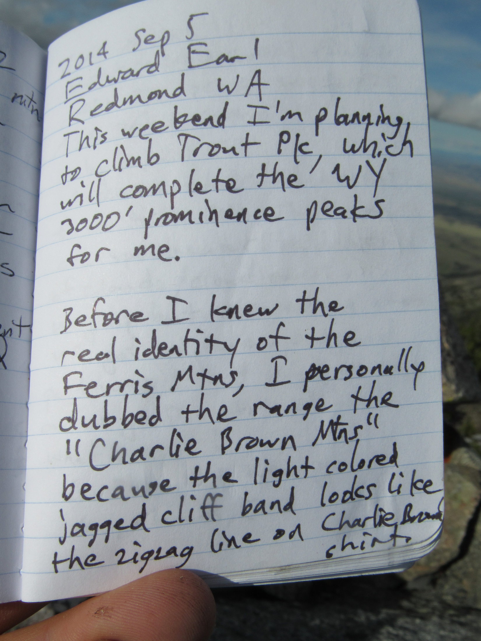
As you drive along I-80 through Rawlins WY, you can see in the distance about 35 miles north a mountain range with a very striking feature: a zigzagging white cliff band running nearly the entire length of the range from left to right. That band is the Madison formation, an upended layer of limestone which has subsequently been eroded into a series of V-notches by a succession of streams coming down from the crest above. I first noticed this mountain range in the late 1980s, and that zigzagging line reminded me of the zigzagging line across the bottom of the shirt that Charlie Brown wears. For this reason, I personally dubbed the range the “Charlie Brown Mountains”.– excerpt from Edward Earl’s trip report on his 9-5-2014 ascent of Ferris Mountain on Peakbagger.com
Rain! Not good. If it rained too hard, the dirt road would turn to mud. The G6 might get stuck way out here NW of Bairoil. Better get back to pavement, now!
It was still dark out, but Lupe was already awake. SPHP had just come to. In pre-dawn rain and fog, SPHP drove back to Bairoil. The rain had already let up to a light sprinkle, by the time Lupe reached the pavement on Hwy 73. May as well keep going.
Eight miles E of Muddy Gap, SPHP turned S off Hwy 220 onto Carbon County Road No. 499. The rain and fog were gone, but dark clouds still hid the Charlie Brown Range. It was light out now, but still very early. Lupe was ready for action! SPHP wasn’t.
Gimme a few more hours snoozing time, Loop. Need to wait a bit to see what the weather’s going to do anyway. And with that, SPHP parked the G6 and went back to sleep.
A few hours later, SPHP was ready. Time for Lupe to take on dreaded Ferris Mountain(10,037 ft.), high point of the entire Charlie Brown Range! Of course, that was provided she could even get close enough to make an attempt feasible.
The first part of the way ought to be easy enough. Lupe could follow directions in peakbagging hero Edward Earl’s trip report. She was already at the first place Mr. Earl mentioned, the sign for Pete Creek Road & Cherry Creek Road at the turn off Hwy 220.
The BLM sign off Hwy 220 at the turn onto Carbon County Road No. 499. Whiskey Peak(9,225 ft.) (L), which Lupe had good time climbing yesterday, is in view. Photo looks SW.
Mr. Earl’s trip report contained detailed instructions on how to get to Ferris Mountain. The next thing to look for was 0.9 mile from Hwy 220 along Carbon County Road No. 499, where a road branching off to the R was marked only by an unreadable sign. This intersection quickly came into view.
The intersection 0.9 mile from Hwy 220 (L) where an unmarked road branches to the R off County Road No. 499 quickly came into view. Photo looks SE.
Mr. Earl’s instructions said to go straight at this first intersection, avoiding the R turn on the unmarked road. 2 miles from Hwy 220 was another R turn, this time onto Cherry Creek Road, which was also to be avoided. Lupe and SPHP stayed on Carbon County Road No. 499 both times, and came to the Handcart Ranch sign 2.5 miles from Hwy 220.
Lupe by the unreadable sign at the first turn to the R, which is the wrong way to go. The G6 is parked along Carbon CR No. 499, which is the correct way.Stay straight on Carbon County Road No. 499. Loop is on the correct route here.At the 2nd turn to the R, which goes to Cherry Creek. Lupe did not take this side road either.Lupe at the Handcart Ranch sign mentioned by Edward Earl as being 2.5 miles from Hwy 220. There was no turn off Carbon County Road No. 499 here.These pronghorn antelope got Lupe excited!
Edward Earl mentioned a fork in the road 4.3 miles from Hwy 220. The R branch goes to a ranch, while Carbon County Road No. 499 continues to the L. Lupe arrived at this fork just as Mr. Earl said.
At the fork in the road 4.3 miles from Hwy 220. Carbon County Road No. 499 goes L here. The road to the R goes to a private ranch headquarters.
Edward Earl also said that the condition of Carbon County Road No. 499 worsened beyond this intersection. He cited frequent mud holes which were dry when he was here, but correctly surmised they were mud puddles during wet weather.
SPHP had scarcely made the L turn at the fork, when there was trouble ahead. A large mud puddle fed by a small stream completely blocked the road. Lupe and SPHP got out for a look.
Lupe inspects the mud puddle and small stream blocking Carbon County Road No. 499.
Nope! Not gonna try it! This mud puddle was as far as the G6 was going. Mr. Earl’s trip report indicated that it wouldn’t be much farther before high clearance would be needed anyway. Even though the base of the Charlie Brown Range where Mr. Earl had parked his Nissan pickup truck was still 6.5 miles away, it was going to be paw and foot for Lupe and SPHP from here. Loopster was in for a very long day!
SPHP parked the G6 in the field next to Carbon County Road No. 499, and proceeded to get ready for Lupe’s long march. The ranch headquarters was in sight from this location, not too far away. Soon a vehicle was seen leaving HQ. A couple minutes later, Lupe and SPHP met Kyra Torgensen and her son. The G6 was parked on the ranch Kyra and her husband own. Naturally, she wanted to know what was going on.
The Torgensen’s ranch HQ was in view from where the G6 was parked. Kyra Torgensen and her son soon drove up wanting to know what was going on.
SPHP explained that Lupe was here to climb Ferris Mountain. It was only another 0.2 mile to BLM land. SPHP would have parked over there, but the G6 couldn’t get past the mud puddle. Did she mind if the G6 was parked here for the day?
Mrs. Torgensen was a little reluctant at first. However, Carbon County Road No. 499 had to be a public right-of-way, which she must have known. SPHP didn’t mention this fact, though, hoping to avoid an argument. In the end, while she may not have been thrilled with the idea, Kyra Torgensen was fine with the G6 where it was. Before she drove away, she warned SPHP not to stay out too late, and to beware of wolves.
A few minutes later, Lupe and SPHP jumped the little stream, and began the long trek to Ferris Mountain (10:17 AM, 68°F). Only 0.2 mile farther, the Carolina Dog went through a gate onto BLM land. The road forked again. Following Edward Earl’s instructions, Lupe took the road to Pete Creek.
After leaving the Torgensen’s ranch, Lupe took BLM Road No. 3148 to Pete Creek. The Charlie Brown Range was still more than 6 miles away.
Lupe and SPHP weren’t worried about wolves. However, Ferris Mountain had long been the most dreaded peakbagging goal of this entire Dingo Vacation. The mountain itself wasn’t the worry. Distance wasn’t either. Forewarned by Edward Earl’s trip report, SPHP had realized all along that Lupe would likely have a 6+ mile trek just to get to the Charlie Brown Range.
The problem was the sagebrush prairie Lupe would have to cross. Two of Lupe’s nemeses might well be out there – cactus and rattlesnakes. If Lupe became scared of cacti, she would refuse to move. Rattlesnakes, of course, would be far worse.
For these reasons, SPHP encouraged Lupe to stay very close, preferably right on the road. Most of the time she did.
A few cacti did grow out on the high prairie. Fortunately, they weren’t too abundant.On the way to the Charlie Brown Range on Pete Creek Road.Wildflowers blooming on the normally arid prairie.
Fortunately, Lupe saw only a few cactus and no rattlesnakes. Meanwhile, the weather remained questionable. Dark clouds hung around. Sometimes they obscured virtually the entire Charlie Brown Range. Other times, they lifted to reveal the mountains. A significant storm was brewing off to the SE. For a while it came closer, but eventually it sailed off to the NE.
Roughly 4 miles from the G6, Lupe came to a cairn on the L side of Pete Creek Road. Edward Earl mentioned 3 cairns in this area, but the Loop only saw 1.
Lupe on the only cairn she saw on the L side of Pete Creek Road. Ferris Mountain, her ultimate goal, is straight up from Lupe’s head. Photo looks S.Lupe at the wire gate described by Edward Earl 9.2 miles from Hwy 220. The view of the mountains ahead shrouded in clouds wasn’t too encouraging at this point.
6.5 miles from the G6, Lupe finally reached the base of the Charlie Brown Range on a grassy ridge E of the mouth of Pete Creek Canyon. A white pickup truck was parked here near the edge of the forest, right about where Edward Earl must have parked his Nissan pickup. Pete Creek Road, which had been going due S for miles, turned SE here.
Lupe at the base of the Charlie Brown Range close to where Edward Earl must have parked his Nissan pickup truck in 2014. Pete Creek Road (No. 3148) (R) heads SE from here. Photo looks SE.
Lupe still had another 0.5 mile to go on Pete Creek Road along the base of the mountains. On the way, she lost 120 feet of elevation crossing the Rush Creek drainage, where she saw a salt lick noted by Edward Earl. By the time she reached a green metal gate near the mouth of Pole Canyon, she had regained all of the lost elevation and a good deal more.
Beyond the green metal gate, Loop finally left Pete Creek Road. She headed into Pole Canyon, and quickly came upon a different faint road heading up the valley.
A pronghorn antelope near Pole Creek, which is hidden in the trees. Photo looks E.Lupe reaches the green metal gate after crossing the Rush Creek drainage on Pete Creek Road. The mouth of Pole Canyon is seen beyond her. Loop left Pete Creek Road near this point. Photo looks S.Starting up Pole Canyon. Photo looks SW.
Edward Earl had followed this same road up Pole Canyon. His trip report mentioned fallen trees and a few marshy spots, but Mr. Earl had been here in September when conditions are much drier. Pole Creek was no occasional marshy spot in the middle of June, but a clear running stream. It was easy enough to wade across, however, and Lupe enjoyed the cold water.
Lupe at the first crossing of Pole Creek.
The road crossed Pole Creek more than once. Lupe also came to marshy glades, where the road hardly existed, but she could usually find it again a little higher up. After a while the road completely disappeared, lost for good.
At another Pole Creek crossing.Loop cools her paws in Pole Creek. By now, the road she had been following had faded away. So far, it was still pretty easy traveling up the R (NW) side of the canyon. The easiest routes usually weren’t right down by the creek.
At 8,450 feet, Loop arrived at the place where Pole Canyon splits. When Edward Earl had been here, only the R (W) branch had flowing water. Both branches had flowing water now. Like Edward Earl, Lupe stayed L (E). As she continued gaining elevation, the creek was increasingly hidden beneath snow.
Loop (behind the tree on the right) reaches the 8,450 foot level where Pole Canyon and the stream divide. She would follow the stream seen on the L here up the E branch of the canyon. Photo looks S.As Lupe continued to gain elevation, the creek was increasingly hidden by snow. Photo looks S.
Lupe stayed to the W (R) of the creek, but it started getting harder to make progress. The forest was dense, and the American Dingo came to more and more rocks and deadfall. The canyon sides steepened, becoming more difficult to traverse. SPHP decided Loop might have an easier time up on the ridge W of the creek.
For a while, leaving the canyon seemed like a good decision. Lupe had no problem reaching the ridgeline. It went straight S rising relentlessly at a pretty good clip, but there was less deadfall to deal with. Sometimes there was even some open ground. When she did come to rock formations, they usually weren’t much trouble to get around. Lupe gained elevation rapidly.
After abandoning the canyon to get up on the ridge to the W, Lupe gained elevation rapidly. Here she is perched on the largest rock formation she had to maneuver around in the early going. Photo looks N.Terrain like this open spot on the ridge was a lot easier to deal with than all the rocks and deadfall in the canyon Loop had left behind. Photo looks S.
It was a long way up. Lupe gained lots of elevation, but the ridge started getting ever steeper and rockier. Huge rock formations appeared above. Looper ended up on steep slopes of broken rock interspersed with spruce trees. This was challenging terrain. SPHP began to fear there wouldn’t be a way to the top.
Lupe had gained a lot of elevation, but the ridge route became increasingly challenging. Lupe found herself on steep slopes of broken rock interspersed with spruce trees. This was slow going. Photo looks SSE.
The ridgeline had basically disappeared. Lupe now seemed to be going straight up the N face of a mountain. She needed to get to easier terrain. SPHP led her up a very steep rocky chute toward a forested saddle between two massive rock formations.
Loop never made it to the saddle. Everything got so steep, progress ground to a halt. At the top of a long, narrow snow bank, SPHP realized that even if Loop could get up to the saddle, she probably didn’t stand much chance of getting over or around the giant rock formations towering above. She would be trapped between them.
Lupe at the top of the snow bank where SPHP realized she needed to down climb and go around this part of the mountain. Photo looks N.
Lupe had to down climb. She needed to get farther E. She didn’t have to lose all that much elevation, but it took a lot of time. Fortunately, it wasn’t terribly far around the huge rock formation above her. Once she managed to get around it, things became easier. The Carolina Dog was still on steep, rocky stuff, but the route up was more manageable.
Once Lupe worked her way around to the E of the massive rock formation that had towered over her, this route up was much more manageable. Photo looks SSE.
Loop climbed and climbed. She was very high, and getting close to the top of something! Her luck needed to hold only a little longer. It did. Suddenly she was there! Lupe stood next to a wooden pole at the top of a big cairn. The views were spectacular!
Lupe climbed and climbed. SPHP could see she was getting close to the top of something. Suddenly she was there, standing on top of a big cairn next to a wooden pole! Photo looks NE.
Had Lupe arrived at the top of Ferris Mountain(10,037 ft.)? The grand views, and presence of the big cairn with the pole sticking out of it made SPHP think so.
A more careful look at the views and a glance at the topo map revealed this wasn’t the case. Lupe was already nearly as high as the true summit, but she was actually on Ferris Mountain’s most westerly sub-peak over 10,000 feet. The true summit was in view from here, still 0.5 mile away to the SE.
Although SPHP initially thought Lupe might have reached the top of Ferris Mountain here, the true summit (R), which wasn’t much higher, was actually still 0.5 mile away. Photo looks SE.
Clearly, the vast majority of the work of climbing Ferris Mountain(10,037 ft.) was done. Getting over to the true summit didn’t look hard. This appeared to be the 2nd highest point on the mountain, and an amazing place. Lupe had time to take a rest break and enjoy the views.
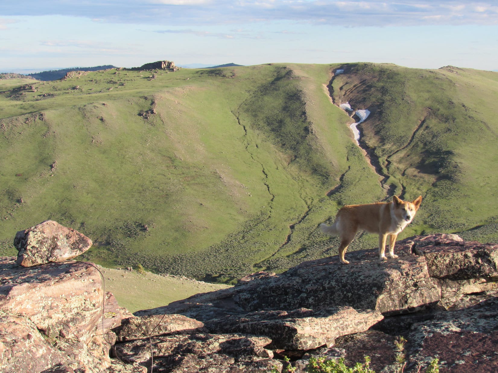
Looking NW along the Charlie Brown Range from the westernmost 10,000+ ft. subpeak of Ferris Mountain.The rocky crag seen below on the L is Ferris Mountain North(9,740 ft.). Far beyond it out on the prairie, part of Pathfinder Reservoir is in view. Photo looks NE.Another look NW with help from the telephoto lens.Looking down on Lupe’s route up. Pole Canyon divides near the center of the photo. Lupe had started up the R (E) branch, but soon got up on the forested ridge between the divided canyons. After that it was mostly straight on up, with a short down climb to get a bit farther E. Pole Canyon empties out onto the prairie on the R. Photo looks N.Lupe takes a break on Ferris Mountain West. Photo looks NW.
After relaxing on fabulous Ferris Mountain West, it was time to move on. The ridge Loop had to follow wasn’t difficult. Her first objective along it was a slightly lower subpeak only 0.1 mile E. She was soon there, looking down on the 9,900 foot saddle where Edward Earl had first reached the ridgeline.
The route along the ridge leading to the true summit of Ferris Mountain (R) didn’t look too difficult. Lupe’s first objective, a slightly lower subpeak 0.1 mile E of Ferris Mountain West is seen on the L. Photo looks ESE.Heading toward the 9,900 foot saddle. Ferris Mountain’s true summit (Center) is seen straight up from Lupe. Ferris Mountain Middle(10,000 ft.) is across the saddle toward the R. Photo looks SE.
Loop went down to the 9,900 foot saddle and crossed it. Edward Earl hadn’t gone all the way up to Ferris Mountain West, but the American Dingo was back on his trail again here. She was now approaching Ferris Mountain Middle(10,000 ft.), the next high point along the ridge.
Looking down on Ferris Mountain North, the rocky crag on the R, from the 9,900 ft. saddle. Photo looks NNW.Lupe approaches Ferris Mountain Middle, the next 10,000+ ft. high point along the ridge. Lupe went around the N (L) side of it before climbing up to the top from the E. Photo looks SE.
The Carolina Dog stayed high as she went around the N side of Ferris Mountain Middle looking for a way to the top. She had to get E beyond the high point before she found a route. Ferris Mountain Middle(10,000 ft.) was another rather dramatic place to be!
After circling around the N (R) side of Ferris Mountain Middle, Lupe found a route to the top from the E. This was a rather dramatic place to be! Photo looks NW.At the top of Ferris Mountain Middle. Photo looks NW.Ferris Mountain West, where Lupe had first come up, is seen in the distance slightly L of Center. Photo looks NW.
Ferris Mountain’s true summit was now no more than 0.25 mile away. A lot of time had gone by. Lupe and SPHP were anxious to get there. The terrain wasn’t difficult, so Loop made great progress.
Approaching the true summit. Photo looks ESE.
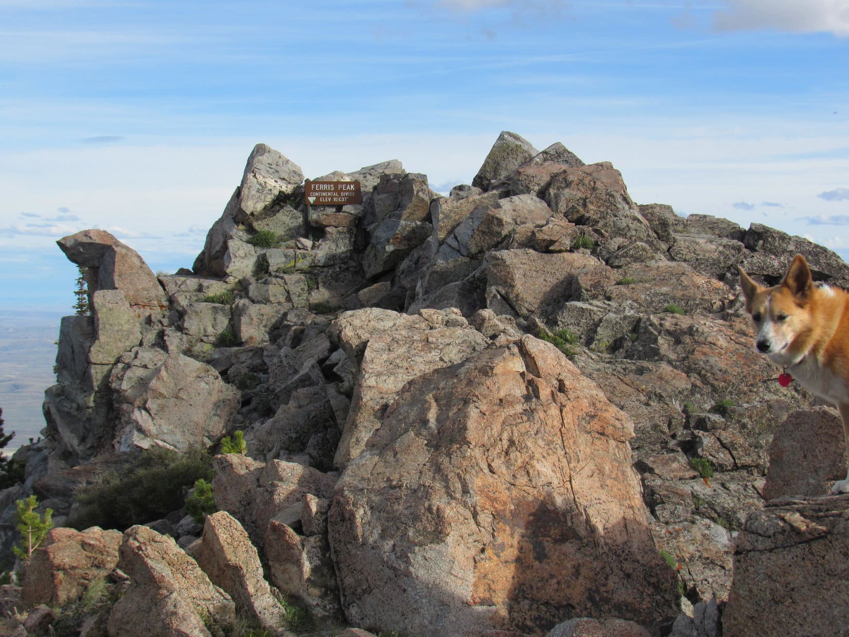
Near the very end, everything was rocky. Fortunately, it still wasn’t too hard getting around. Lupe seemed to be running out of mountain, when suddenly the summit appeared ahead. Right below the highest rocks, a metal sign said “Ferris Peak, Continental Divide, 10,037 ft.” Lupe had made it!
This what we’ve been looking for, SPHP? …. Yes, ma’am, that’s it, sweet Puppy!On Ferris Mountain at the top of the Charlie Brown Range. Photo looks S.Ferris Mountain summit. Photo looks S.
What a tremendous mountain! The views were superb. The weather was vastly improved from what it’d been this morning. Beauty shone forth in every direction in the early evening light. A glorious day! SPHP congratulated Lupe on her grand success, shaking her freckled paw.
Scrambling the short remaining distance to the highest rocks, Lupe came across two survey markers. At the very top, tucked among rocks near the metal sign, she found a plastic jar. Inside was a registry. SPHP was eager to have a look at.
Was it there? Yes, it was! Happy day! SPHP found the entry by Edward Earl.
One of two survey markers Lupe found on Ferris Mountain.Survey marker No. 2.The plastic jar containing the registry in its hiding place behind the metal sign.Edward Earl’s 9-5-2014 entry in the Ferris Mountain registry.
Seeing that Edward Earl had written about the Charlie Brown Mountains made SPHP smile. Lupe had been to quite a few mountains with assistance from Mr. Earl’s detailed trip reports. Once again, she was at the top of a mountain Edward had been to before her. Sadly, Lupe would never get to meet him.
Edward Earl had perished tragically nearly 2 years ago on 6-19-2015, drowned in the rushing Jago River in the Brooks Range in NE Alaska following two failed attempts to climb Mount Isto(8,976 ft.).
Others appreciate Edward Earl’s excellent route descriptions, too. John Stolk of Redmond, WA mentioned Edward in his registry entry dated 8-21-16.Lupe’s entry in the Ferris Mountain registry.Lupe taking it easy in the least uncomfortable spot she could find on Ferris Mountain while waiting for SPHP to finish with the registry. The registry showed that 4 other people had been here earlier today, but Loop never saw anyone.
Lupe rested among the rocks, while SPHP fiddled with the registry. When SPHP was finally done, it was time to spend a while contemplating the tremendous views.
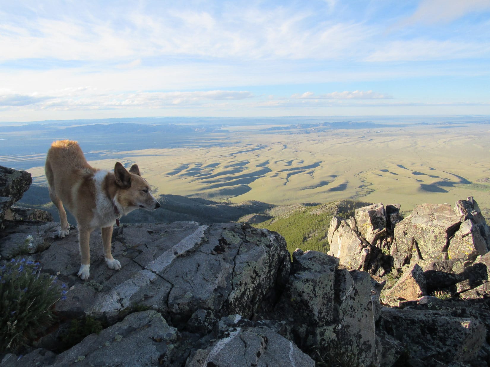
Lupe looking beautiful in the evening light up on Ferris Mountain. Photo looks N.View to the SE.
Looking S. Edward Earl was once where Lupe was now.Final moments at the top.Looking NW from the summit. Ferris Mountain’s westernmost 10,000+ foot high point where Lupe came up is in the distance on the L.Lupe had seen these same dome-like hills from Whiskey Peak(9,225 ft.) a day earlier. Photo looks NW with help from the telephoto lens.Pathfinder Reservoir from Ferris Mountain. Photo looks NE with help from the telephoto lens.The Pedro Mountains rise on the far side of the southern end of Pathfinder Reservoir. Photo looks E with help from the telephoto lens.
All too soon, the angle of the sun insisted it was time to move on. Lupe left Ferris Mountain starting back the way she’d come up. SPHP figured the American Dingo still had some time to spare. She revisited the summit of Ferris Mountain Middle.
Lupe returns to the top of Ferris Mountain Middle. On the way back the plan was to visit Ferris Mountain North, the rocky knob on the R, too. Photo looks NW.Ferris Mountain North (R) from Ferris Mountain Middle. Photo looks NW.Ferris Mountain West (L) from Ferris Mountain Middle. Lupe wasn’t going all the way back over there on her way down.
From Ferris Mountain Middle, Lupe went down to the 9,900 foot saddle. She was about to leave the mountain’s main ridgeline. Before continuing down, she took a last look at the huge expanse of prairie S of the Charlie Brown Range.
Before leaving the 9,900 foot saddle, Lupe took a final look at the huge expanse of prairie S of the Charlie Brown Range. Photo looks SW.
She then turned her attention to her final peakbagging objective of the day, Ferris Mountain North(9,740 ft.).
Looking down on Ferris Mountain North from the 9,900 foot saddle. Photo looks N with help from the telephoto lens.
Looper headed down to the 9,700 foot saddle leading to Ferris Mountain North. She went N toward the high point. As she got close, she circled around to the E where it wasn’t as steep. Lupe quickly found a rocky route to the top.
Approaching the top of Ferris Mountain North from the SE.
To the S, were the forested upper N slopes of Ferris Mountain leading to the ridge where the Carolina Dog had spent the last several hours atop the Charlie Brown Range. To the N, thirsty sagebrush prairie stretched away to distant hills. Shadows of ridges made the land look like ripples on a sea.
Lupe on Ferris Mountain North with a view of the NE side of the Charlie Brown Mountains. Photo looks NW.Ferris Mountain (L), Ferris Mountain Middle (Center), and the 9,900 foot saddle (R) from Ferris Mountain North. Photo looks SE.Looking down on the 9,700 foot saddle from Ferris Mountain North. The 9,900 foot saddle is seen up on the ridge on the L. Ferris Mountain Middle is the high point on the far L. Photo looks S.A commanding view to the N.Looking NNW.
Lupe couldn’t linger long on Ferris Mountain North. She was 2 miles from the green metal gate near the mouth of Pole Canyon. Another 7 miles to the G6. After a good look around, and a little time spent in contemplation, Lupe headed back to the 9,700 foot saddle.
Downhill all the way now! The Carolina Dog plunged N down into the E branch of Pole Canyon. The forest was a maze of 3 to 5 foot high snow drifts and deadfall timber, but this route was easier than the way Lupe had gone up. The terrain was only moderately steep, and not too rocky.
Loop soon discovered that the roughest ground was at the bottom of the canyon. For a long way, she stayed E and higher up, sometimes more than 100 feet above the creekbed. The snowbanks shrank and became less numerous, as she lost elevation.
By the time Lupe was low enough so most of the snow was gone, the deadfall wasn’t as bad either. She now made fast progress, which was a good thing. The sun, though still up, was hidden behind the mountains. Sunset couldn’t be too far off.
As Lupe drew near the point where both branches of Pole Canyon converge, the terrain changed. Lupe made her way to the bottom of the canyon, and leapt over to the W side of the creek. She soon came to the stream confluence, and had to make one more crossing. For a while she traveled down Pole Canyon staying W or NW of the stream.
To avoid the larger stream crossings and swampy ground closer to the mouth of Pole Canyon, Lupe eventually got up on the side of the ridge to the NW. Nearing the base of the Charlie Brown Range, she reached the ridgeline. The sun was down, the land dark. Thin clouds glowed brilliantly orange in a pale sky.
The colorful display faded to gray. Lupe managed to reach the green metal gate before it was too dark to see. Still 7 miles to go, but Loop had made it to Pete Creek Road. After crossing the Rush Creek drainage, the road turned N. All gently downhill from here.
Lupe and SPHP marched away from the Charlie Brown Range, never looking back. Only blackness was behind. Ahead, distant headlights on Hwy 220. The infinite universe glittered above.
Every now and then Lupe heard something, and went racing away into the night. Antelope? Rabbits? No telling. Fortunately, the luck of the Dingo held. She always came streaking back, panting happily. No cactus had stabbed her. No rattler had bit her. No wolves had devoured her.
Ferris Mountain had been a fabulous day! Yet, things don’t always go one’s way. Luck can run out. Perhaps weariness, or the silent black night was to blame, but during the long trek back it was hard not to think about another adventurer who had come this way. An adventurer who ultimately helped make this day a success for beloved Lupe, but whose luck had run out nearly 2 years ago.
It was hard not to ponder the life and times, and tragic fate of Edward Earl. (12:05 AM)


 The good news was that it was permissible to climb right up onto Independence Rock! The best way up was from the NW. Used to climbing mountains, getting to the top was easy for Lupe. She was there in practically no time.
 Lupe saw some names carved in the rock, but as SPHP read them off, it turned out that Loop didn’t personally know any of these pioneers. The Carolina Dog lost interest. She wanted to look and sniff around. A view of a herd of delicious black cows grazing down by the Sweetwater River was especially interesting.


 SPHP wanted to do one more thing here, which was to walk down to the Sweetwater River. Lupe thought that might not be such a bad idea, since those black cows were somewhere along the river.