Black Hills, SD Expedition No. 324 – Line Camp Peak & Horse Trap Mountain (1-31-24)

7:59 AM, 28ºF, Cascade Falls, S of Hot Springs – Shadows were long, but the day already bright as the sun came peeping over the mountains.  The steps leading down to Cascade Creek from the picnic ground were icy, forcing SPHP to use the railing for support.  Reaching Cascade Falls, mist was rising into the chilly morning air from both the swimming hole, and the lukewarm stream tumbling into it.

Arriving early at Cascade Falls. Photo looks SW.
Cascade Falls. Photo looks NW.

Beautiful!  Love Cascade Falls, SPHP, but it’s still January!  Kind of early in the season to go swimming, isn’t it?

Ha!  No doubt, Loopster!  Not too early to do a little wading, though.

As SPHP sat down and began removing boots and socks, the Carolina Dog appeared more concerned than convinced.

Cascade Creek immediately above the falls. Photo looks NNW.

Even though the water wasn’t all that cold or deep, Lupe was reluctant to follow SPHP into the stream.  The creek bottom was smooth and firm, but uneven with sudden drops of a foot or more, enough to freak the American Dingo out a bit, causing her to freeze up midstream.

Reluctantly midstream. Photo looks NNE.

Just follow me, Loop.  It’s not deep at all, if you take the exact same route.

After fording Cascade Creek, SPHP sat down and began putting socks and boots back on again.

Aren’t we staying here at the creek like we’ve always done before, SPHP?

Nope.  Cascade Falls may be a great place to hang out during the summer, Looper, but we’re actually here to visit Line Camp Peak (4,530 ft.) today.

Line Camp Peak?  Never heard of it, SPHP.

That’s the name I just gave it, Loop, because the topo map shows a Line Camp 0.33 mile SW of the summit.  On Lists of John, it’s merely Peak 4535.

Oh, I get it!  We’re back to tagging Lists of John peaks with a minimum of 300 feet of prominence.  What is a line camp, anyway, SPHP?

Really don’t know, Loopster.  If I had to guess, I’d think a temporary work camp near the construction of some sort of road or utility.  Way out here, maybe a pipeline or powerline.  With any luck, maybe we’ll find out today.

Scrambling up the steep, heavily forested bank on the W side of Cascade Creek through pines, junipers, and bushes, the terrain leveled out after a 40 foot climb.  Another steep-sided ravine full of pines and junipers was now to the L with grasslands visible above both sides.

On the NE side of Falls Canyon. Photo looks NW.

This big ravine is Falls Canyon, Loop, but we’re on the wrong side.  We’re going to have to find a place to get across.

Although Falls Canyon was only 40 feet deep, Lupe was above a cliff with standing water below it.  Heading NW, there was already a nice view of Devils Slide Mountain (3,960 ft.) back to the NE.

Beginning the search for a way across Falls Canyon. Photo looks WNW.
Devils Slide Mountain (L). Photo looks NE.

After only 0.15 mile, the canyon divided.  Falls Canyon turned N, while Mike Canyon continued NW.  Lupe easily descended into Falls Canyon and climbed back out again here, but now had to cross Mike Canyon, as well.  Another 0.1 mile NW got her to a good spot to enter Mike Canyon.

Exploring Mike Canyon. Photo looks E.

The terrain in the canyon was rolling and grassy, with a few inches of snow lingering along the more shaded SW side.  Although the SW slope wasn’t a cliff, it was still mighty steep.  Fortunately, Lupe didn’t have to sniff her way much farther up the canyon to find a spot where it was possible to scramble up and out, entering a region of typical western South Dakota prairie.

Up on the prairie. Photo looks SW.

S of Mike Canyon now, the prairie rose in a long, gradual climb as Lupe headed W.  Didn’t take her long to notice that grass wasn’t the only thing growing out here.  The Carolina Dog’s nemesis was here, too.

Yeouch!  SPHP, there’s cactus!

Lots of it, too.  Progress slowed as Lupe insisted upon playing the cactus game.  Remaining in one spot while SPHP scouted ahead, Lupe refused to budge until SPHP gave the signal that the route was cacti-free.

Playing the cactus game. Devils Slide Mountain (L). Photo looks E.

In some places, the cactus was so thick that carrying Lupe was the only way to keep going.

I sure hope it isn’t very far to Line Camp Peak, SPHP!

It’s a bit of a stroll, Loopster.  Nearly 7 miles from Cascade Falls.

7 miles!  We’ll never make it, SPHP!  You can’t carry me that far, and I’m not walking barepaw through cactus infested fields for any 7 miles.  You try it!  It’s not fun.

Ahh, but there’s a road that goes nearly the entire way, Loop.  We’ll soon come to it.

A road?  Why didn’t you say so?  That’s different, SPHP.

Continuing W, the terrain finally leveled out.  From the top of a small rise, the Cheyenne River valley was now in sight off to the SW.

Cheyenne River valley (Center). Photo looks SW.

Alright!  Almost there, Looper.  USFS Road No. 647 should be just down this little slope about where the trees start.  In fact, I think I see it.

Reaching the road put an end to the American Dingo’s cactus concerns.  Turning NW again, her road hike commenced.

On USFS Road No. 647. Photo looks NW.

No. 647 was a scenic, easy march.  Trending NW for miles through both prairie and open pine forests, the road steadily gained elevation.  Soon Lupe was high enough to see Nebraska way off to the S.

Among the pines of the open forest. Photo looks NNE.
Nebraska on the distant horizon. Photo looks SSE.

The Black Hills had been very warm for January recently, and today was no exception.  The morning was warming up fast as the sun climbed into the cloudless sky.  Very little snow remained, but Lupe was happy to find enough melting in the shade here and there to eat for a bit of moisture whenever she got thirsty.

Nothing happened on this pleasant journey until, approaching HP4040 after 2 miles on No. 647, the American Dingo spotted movement ahead.  A lone horse with a thick black mane was running around up here.  The horse trotted through the fields for a few minutes before disappearing into the forest, evidently on its way to some unknown destination.

Approaching HP4040 (R). Photo looks NW.
Black Mane“, the handsome horse of HP4040.

The road didn’t go all the way to the top of HP4040, instead flattening out as it turned W for a short stretch before losing 50 feet of elevation winding NW down into the uppermost reaches of Cedar Canyon.

About to descend into the upper reaches of Cedar Canyon (L). Photo looks WNW.

The uphill trek soon resumed as a somewhat steeper climb.  Once out of Cedar Canyon, tablelands were in sight beyond Wildcat Canyon.  Views of Wildcat Canyon improved as Lupe continued on.

Tablelands (Center) beyond the Wildcat Canyon region. Photo look W.
Wildcat Canyon (R). Nebraska on the horizon again. Photo looks S.

A level stretch led to yet another gradual climb, which topped out near HP4154. However, there were enough trees up here to block any distant views, at least from along the road.

Approaching HP4154 (Center). Photo looks NW.

Beyond HP4154, more open territory provided a good look at the upper reaches of one of the branches of Wildcat Canyon.  However, the views were even better just a little farther on, when the road swung over to the NE side of the long ridge it was following.  Looking across Buck Canyon, quite a few peaks Lupe had once been to long, long ago were in sight.

Upper end of Wildcat Canyon (beyond Lupe). Photo looks WNW.

Oh my gosh, SPHP!  There’s Roundtop Hill (4,469 ft.) and the Seven Sisters Range (4,420 ft.)!

Yup.  And if you look down Buck Canyon, Loopster, you can see not only Devils Slide Mountain (3,960 ft.) a mile or so from where we started, but Flagpole Mountain (4,320 ft.) as well.

Roundtop Hill (L) and Seven Sisters Range (R) beyond Buck Canyon. Photo looks NE.
Devils Slide Mountain (L of Center) and Flagpole Mountain (R) in the distance. Buck Canyon (foreground). Photo looks SE.

Looks like we’ve come a long way already, SPHP.

Yeah, we’ve definitely made some progress, Loop.  Still 1.5+ miles to Line Camp Peak, though.

For the next 0.67 mile, USFS Road No. 647 ran along the shady SW side of Buck Canyon, all mushy and wet with melting snow.  After going up this incline, the rate of climb greatly diminished as the road turned W again for a little way before resuming its NW course.  In this flat region, a large power line soon appeared ahead.

Heading up the muddy stretch along the SW side of Buck Canyon. Photo looks NNW.
At the power line. Photo looks SW.

Hey!  This power line might be why the line camp is on Line Camp Peak, SPHP.

Don’t know, Loop.  According to the map, the line camp is still 0.67 mile NW.  Seems sort of far.  Plenty of excellent space right here for a camp, if it was meant to support the construction of this power line.

Continuing NW past the power line, it wasn’t much farther to a fork in the road.  Taking the R fork, Lupe headed N through a huge, very gently sloping field.  Line Camp Peak’s summit was now only another 0.25 mile, hidden somewhere among the pines directly ahead.

On the grassy summit plateau of Line Camp Peak. Photo looks N.

However, something else caught Lupe’s attention.  Over toward the W end of the field, a whole herd of horses was hanging out near the area where the line camp was supposed to be.

Horses near the Line Camp region. Photo looks W with help from the telephoto lens.

Oh, I love horses, SPHP!  Do you suppose they’re friendly?  Maybe we should go see them?  We can check out the line camp, too!

Whether friendly or not, let’s leave ’em be, Loop.  The line camp mystery is of secondary importance.  Let’s do what we came to do, first.

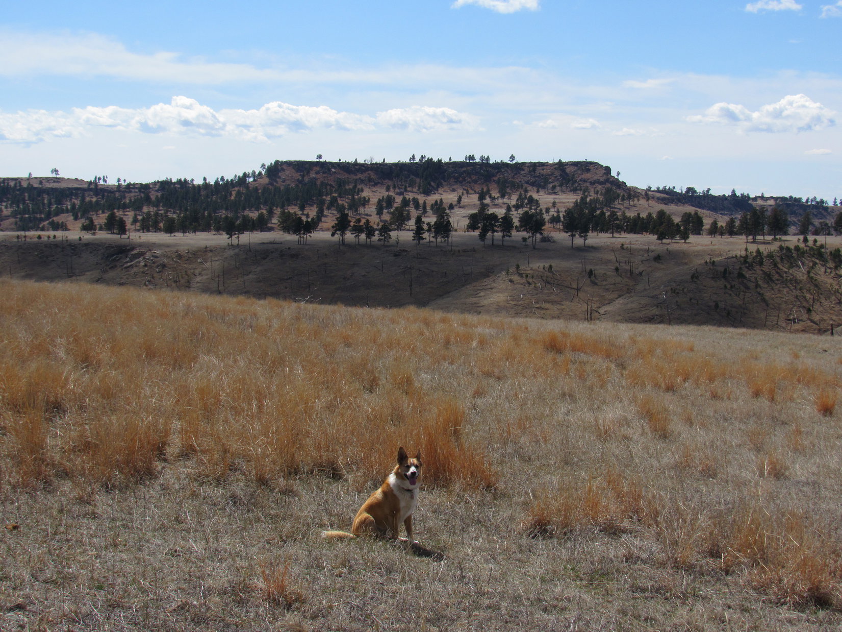
12:32 PM, 60ºF, Line Camp Peak (4,530 ft.) – Located near the NE end of the enormous summit plateau, Line Camp Peak’s true summit proved to be along a rocky, pine-covered, E/W running ridge that rose 10-15 feet above the immediately surrounding area.  Only tree-broken views were available from the top, but a little SE of the summit, Lupe enjoyed a great view to the E across multiple canyons.

Seven Sisters Range (L) and Devils Slide Mountain (R) from Line Camp Peak. Photo looks E.
On one of the highest boulders of the summit ridge. Photo looks NNW.
Tree-broken views from the summit ridge. Photo looks SE.
At the true summit. Photo looks N.

A long march, but an easy one!  Congratulations, Loopster, you’ve made it to Line Camp Peak!  May I shake your paw?

Not all of it was as easy as you make it sound, SPHP!  But, yes, go ahead, you may shake my cactus-stabbed paw.  Gently, please!

For the last day of January, this was an extraordinary day.  Although wind now sighed in the treetops, the breeze was only light and variable at ground level, and at a sunny 60ºF, the air was pleasantly warm.  For a while, Lupe and SPHP relaxed on patches of grass near the true summit after sharing water and a chocolate coconut bar.

There’d already been a few brief water and Taste of the Wild breaks on the way here, and the American Dingo scarfed up some more as SPHP munched on an apple.  Facing S toward the main part of the plateau, a glimpse of Nebraska was visible between the trees.

The break spot next to the true summit. Photo looks ESE.
Nebraska (L of Center) on the horizon. Photo looks S.

Time ticked away as it always does.

Very nice here, isn’t it, Looper?

Absolutely, SPHP.  I loved all the canyon views and seeing some of the peaks we haven’t been to in a long time on the way here, too.

Me, too, Loop.  Getting to be 1:00 PM, though, and the days aren’t very long this time of year.

We’ve only been here half an hour, SPHP.  You aren’t saying we have to leave already, are you?  Can’t we at least stay for the rest of my traditional summit hour?  Or maybe you’re wanting to spend the second half of it checking out the line camp?  I’d do that.

Actually have something else in mind.  Horse Trap Mountain (4,682 ft.) is only a little over a mile N of here.  Been a long time ago, but remember how scenic it was up there, Loopster?  Would be fun to return for a little while, if the skinny ridge leading to it is negotiable.

A chance to visit Horse Trap Mountain again, SPHP?  Let’s do it!

Alright.  We better get with it, though, Loop.  Taking on Horse Trap means we’ll be getting back long after dark, even if we leave right now.  However, before we go, stand on the true summit of Line Camp Peak here again for a minute.  There’s kind of an interesting view showing that there’s a hollow spot beneath it.

Back on the true summit of Line Camp Peak. Photo looks NW.

1:01 PM – Setting out for Horse Trap Mountain, Lupe wandered W along Line Camp Peak’s little summit ridge, turning NW once it melted away in the forest.  To SPHP’s surprise, the Carolina Dog quickly discovered an old road that went N, exactly the direction she needed to go.

A short descent led to a grassy bench, where a cluster of rocks along the NW edge promised a grand view of Hell Canyon.  Going over to them, the view didn’t disappoint at all.

On the grassy bench at the far N end of Line Camp Peak. Photo looks NW.
Hell Canyon from the N end of Line Camp Peak. Photo looks WSW.

Wow!  This is gorgeous, Loop!  Love this kind of territory.  Doesn’t look like “Hell” Canyon at all to me.

Heh.  Beautiful enough, SPHP.  Probably full of cactus, though!

From the far N end of this bench, Lupe’s next objective was in sight.

Horse Trap Mountain (R of Center). Photo looks N.

There it is in all its glory, SPHP!  Horse Trap Mountain!  Doesn’t look like a difficult climb, either, if we can get down to the saddle leading to it.

Fortunately, getting to the saddle was no problem.  The ancient jeep trail Lupe had found wound down to an intersection with USFS Road No. 327, which ran E/W right over it.

Following the old jeep trail (L) down to the saddle leading to Horse Trap Mountain (R). Photo looks N.
HP4656 (Center) above the upper reaches of Hell Canyon. Photo looks N.
HP4500 (Center) along Line Camp Peak’s E ridge. Photo looks ESE.

Crossing the saddle, the wind was 20 mph out of the W as Lupe started up Horse Trap Mountain’s S ridge.  This fairly steep climb was actually a bit dangerous for the Carolina Dog due to a pair of parallel barbed wire fences running straight up the ridgeline, one of which was flat on the ground much of the way.

At one point, SPHP had to give the American Dingo a boost at a rocky spot, although Lupe could have gone around it, if necessary.  Views were already marvelous from a couple of high points crossed during the 450 foot ascent.  From the second one, Lupe had a terrific view of Horse Trap Mountain’s S face.

A band of limestone cliffs running along the upper rim appeared to have enough breaks in it to ensure a successful ascent.

Heading up Horse Trap Mountain’s S ridge. Line Camp Peak (L), Hell Canyon (R). Photo looks SSW.
S face of Horse Trap Mountain from HP4550. Photo looks N.

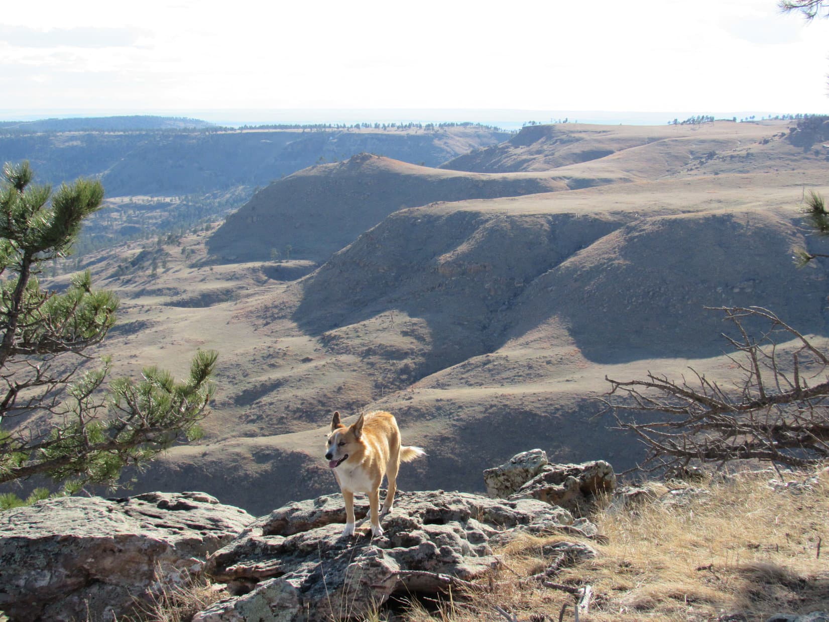
Nothing to it!  As Lupe closed in on the S face, a readily discernable trail went right on up.  From atop the rocks along the S rim, Lupe enjoyed a tremendous view of Falls Canyon with Devils Slide Mountain (3,960 ft.) and Flagpole Mountain (4,320 ft.) beyond, and the prairies of western South Dakota stretching to the edge of vision beyond them.

Approaching the S rim of Horse Trap Mountain. Photo looks NW.
Falls Canyon (Center), Devils Slide Mountain (L of Center), Flagpole Mountain (Center). Photo looks SE.
HP4550 (L) along Horse Trap Mountain’s S ridge. Line Camp Peak (Center), Hell Canyon (R). Photo looks SSW.

2:16 PM, 57ºF, Horse Trap Mountain (4,682 ft.) –  Lupe had come up at the lower S end of a huge, oval summit plateau covered with grass and scattered pines.  Sloping gently up to the N, this plateau was ringed by a line of small cliffs around virtually the entire perimeter.  Having been here once before, the Carolina Dog knew the true summit was along the opposite NNW edge.

Any preferences, SPHP?  Want to go straight for the true summit, or circle around the perimeter where all the big views are?

Around the perimeter, Loopster.  After all, the unobstructed views from this island in the sky are what make Horse Trap Mountain so special.

Clockwise, or counter-clockwise then, SPHP?

Your choice, Loop.  Either way is fine with me.

Lupe chose clockwise.  Within minutes she reached a particularly scenic overlook along the SW edge from rock formations providing a superb view of Line Camp Peak, lower Hell Canyon, and barren ridges to the W.

Line Camp Peak (L edge), Hell Canyon (L), and barren tablelands (R). Photo looks SW.
Line Camp Peak (L), Hell Canyon (Center), tablelands (R). Photo looks SSW.

Circling around to the NW edge, the upper reaches of Hell Canyon were in sight.  The top of Parker Peak (4,848 ft.), the Fall River county high point, was also visible, sticking up behind them.

Parker Peak (L of Center) beyond upper Hell Canyon. Photo looks NW.

2:27 PM – The wind was only 5-10 mph out of the NW by the time Lupe reached the true summit of Horse Trap Mountain after a leisurely stroll around the W end of the plateau.  A couple of photos atop the summit rock, the usual congratulatory pawshake, and it was time for a break.

At the true summit of Horse Trap Mountain. Photo looks NNW.
Parker Peak (R) from the true summit. Photo looks WNW.
Taking it easy on Horse Trap Mountain. Parker Peak (Center), true summit rock (R). Photo looks NW.

Hard to believe we’re here again after all these years, Loop!  So glad we came!  Horse Trap Mountain is every bit as fabulous as I remembered it.

Most definitely agree, SPHP!  Easily worthy of a chocolate coconut bar, maybe 2 or 3!

Um, yeah.  Only one left, Loopster, but I do have a duck jerky for you, too.

Both were eagerly accepted, along with Taste of the Wild and water, then Lupe laid her head down.

Mind if I snooze for a bit, SPHP?

Not at all, Looper.  It’s already been a long day.

SPHP drank a strawberry Equate and chomped the last apple.  Only the sound of the wind broke a perfect silence.  Amazing, unspoiled territory of this remote part of the Black Hills laid in all directions.

A glimpse of Elk Benchmark (5,669 ft.) and Wildcat Peak (5,500 ft.) was far to the NW.  Black Elk Peak (7,131 ft.) was but a distant blip to the N.  SPHP peered into Hell Canyon.  Gorgeous, but Lupe might be right.  Maybe it was full of cactus?

After a short nap, the Carolina Dog woke up and accompanied SPHP on a stroll to other nearby viewpoints.

Looking NNE.
Parker Peak (L) again. Photo looks NW.
Horse Trap Mountain summit plateau. Photo looks SE.

3:15 PM, Horse Trap Mountain –  The inevitable sad moment arrived.

About time to get back on the top rock, Loop.

Summit hour’s over already, SPHP?

Hate to say it, but yup, pretty quick now, Loopster.

At least we can still enjoy completing our circumnavigation of the summit plateau, SPHP.

Final moments on the true summit of Horse Trap Mountain. Photo looks NW.

A brief return to the true summit, and Lupe was on her way, this time circling around the E end of the plateau.

Leaving the true summit region. Photo looks E.

The views were grand going this way, too.  All too soon, Lupe was back at the S end of the plateau, ready to start her descent along the S ridge.

Falls Canyon (L & Center) from the E edge. Devils Slide Mountain (L) and Flagpole Mountain (L of Center). Photo looks SE.
Roundtop Hill (Center in foreground). Photo looks ESE with help from the telephoto lens.
Back at the S end. HP4550 and Line Camp Peak (L of Center), Hell Canyon (R). Photo looks S.

4:43 PM, 55ºF – The wind had died completely, and the rapidly setting sun was already on the horizon by the time the American Dingo reached the summit of Line Camp Peak (4,530 ft.) again.  She wouldn’t get much of a rest break at all here this time around.

Sunset from the summit of Line Camp Peak. Photo looks W.

Enjoy it while you can, Looper.  10 minutes, then we’re moving on.

What about the line camp, SPHP?  Are we ever going to check it out?

Yup.  That’s why we’re in a rush.  Going to be too dark to see anything, if we don’t get over there pretty quick.

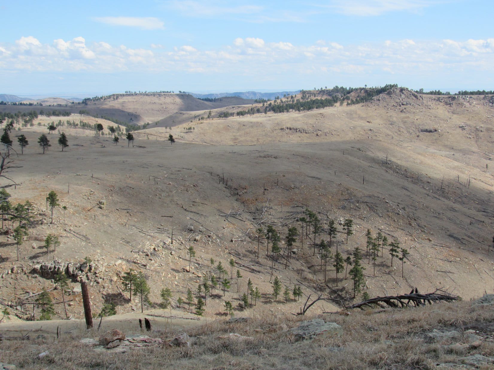
The last rays of sunshine were filtering through the trees as Lupe headed SW across the big field where the horses had been earlier in the day.  No sign of them now.  SPHP overshot the turn W to the line camp.  Lupe was well on her way to HP4509 before SPHP realized the error.

Doubling back in haste, dusk was deepening among the pines when the Carolina Dog reached the location marked as the line camp on the map.  Nothing here.  No towers, sheds, shacks, or other structures at all, only a few pieces of metal quietly rusting away in the tall grass.

So what makes this a line camp, SPHP?

No idea, Loop.  Only our cartographer knows for sure.  Had no idea what to expect from a line camp, and still don’t, except maybe not much at all.

Exploring farther along the N edge of the point W of the line camp, trees hid the views, except from one spot where Lupe caught a final glimpse of a familiar sight.

Horse Trap Mountain (L) from W of the Line Camp. Photo looks NNE.

And that was it.  The return march back along USFS Road No. 647 was even easier now going downhill.  Lupe barked at a small plane that flew almost directly overhead while there was still light in the sky.  However, it wasn’t long before the tiny flashlight had to come out.

On this black, moonless night, the Milky Way was stunningly bright.  Rising in the SE, Orion was directly ahead.  Back to the N, the Big Dipper stood on end.  Geese honked as they flew by unseen, and coyotes sang a wild, mournful chorus before silence reigned again.  Many miles away widely dispersed lights revealed the locations of remote ranch homes.

Nearly 14 hours after leaving the RAV, Lupe forded Cascade Creek again, completely unfazed by the jet black water or ghostly mist rising from it.

Line Camp Peak and Horse Trap Mountain!  What a magnificent day they had been!  (9:55 PM, 36ºF)

Line Camp Peak from Horse Trap Mountain, Black Hills of South Dakota 1-31-24

Links:

Next Black Hills Expedition                Prior Black Hills Expedition

Want more Lupe adventures?  Check out Lupe’s Black Hills, SD & WY Expeditions Adventure Index, Master Adventure Index, or subscribe free to new Lupe adventures!

Black Hills, SD Expedition No. 197 – Parker Peak & Horse Trap Mountain (3-27-17)

Start (10:49 AM, 54°F)

Crocuses!  Lupe discovered pale, lavender crocuses along the trail, not many, but a few here and there.  No denying it now, spring had arrived in the Black Hills!  As far as Lupe was concerned, crocuses were infinitely better than the cacti she had been reluctantly dealing with on her recent Black Hills expeditions.  SPHP couldn’t have agreed more.

Crocuses herald the arrival of spring in the Black Hills.

The trail had led Lupe right up to the top of the broad ridge.  The ridge ran for miles E/W, and had a number of large extensions to the S.  Most of the ground up here was rolling grasslands, rimmed by Ponderosa pines along the edges, with more pines scattered in various places across the open ground.

Lupe arrives up on the broad ridge that ran for miles E/W. The survey benchmark, at the top of the pipe seen sticking up out of the ground beneath her, provided SPHP with a good indication of her precise location. Photo looks SW.

The question was, which way to go from here?  The plan was to follow 4WD roads up on this huge ridge to Lupe’s two peakbagging objectives of the day – Parker Peak (4,848 ft.) and Horse Trap Mountain (4,682 ft.), but neither mountain was in sight, nor was any road visible.  Maybe the old roads shown both on the Peakbagger.com topo map and SPHP’s old Black Hills USFS map didn’t even exist anymore?  Entirely possible.

What was for certain was that Parker Peak, the high point of Fall River county, was miles away at the far W end of this ridge.  Horse Trap Mountain, however, was somewhere closer by to the S.  Maybe it was still E of here?

Lupe explored E along a fence line, going up to the crest of a gentle rise where a few large pines were clustered.  Looking E and SE from here revealed nothing.  All the terrain was nearly as high, and a lot of it was forested.  No sign of Horse Trap Mountain.

The only thing Lupe discovered by going E was that crocuses weren’t present up on top of this ridge.  Instead, her feared cactus nemesis was.  Not a lot of cactus, but enough so SPHP carried her over one small patch.  The cactus wasn’t a surprise, SPHP had expected it.  Even up on this high ridge, Lupe was still below cactus line.

Going farther E didn’t look promising.  Lupe retraced her steps, returning to where the trail had first brought her up to the top of the ridge.  At the fence corner, Lupe came to a pipe sticking up out of the ground.  SPHP hadn’t noticed it before.  A survey benchmark at the top of the pipe provided a clue, such a good clue that after consulting the maps, SPHP knew exactly where Lupe was.  Horse Trap Mountain was more than 2 miles SSW of here.

SPHP started leading Lupe WSW down toward an earthen dam for a dried up stock pond.  However, Loop was now wary.  The foray to the E had shown her that cactus was present.  She followed SPHP reluctantly.

Crossing the earthen dam, Lupe didn’t notice the one cluster of cactus growing on it.  Her confidence started returning.  SPHP enticed her SW up to the top of the next rise without much of a problem.  By staying where there were trees, the chance of encountering more cactus was reduced.

Unfortunately, the ridge didn’t have enough trees to provide continuous shade.  Lupe soon realized cactus was up here, too.  She insisted upon returning to her now familiar method for dealing with cacti.  The Carolina Dog stood or sat motionless while SPHP scouted ahead.  She would only come when SPHP sat on the ground to signal that the route was safe.

In some places it wasn’t safe.  SPHP had to carry the American Dingo a few times over the thicker cactus patches.  It would sure help to find a road, any kind of a road.  Lupe would be willing to trot along a road confident that cactus wouldn’t be on it.

Lupe was in luck!  A little down over the other side of the rise, she did find a road.  The road was faint and seldom used, even grassy, but it was a road.  Upon reaching it, Lupe was immediately relieved of the worst of her cactus worries.  She was willing to travel the road without her time consuming cacti technique being employed.

The grassy road went S.  Within minutes, Lupe passed by the ruins of an old cabin.  A little farther on, the road came to a major intersection in a clearing.  Dirt roads radiated out in 4 or 5 directions.  Ahead, across a tree filled canyon, Lupe saw an interesting butte in the distance.  SPHP didn’t realize it at first, but this was Lupe’s first view of Horse Trap Mountain.

Lupe near the major dirt road intersection. The butte in the distance is Horse Trap Mountain. Photo looks SSW.

A canyon was between Lupe and the interesting butte.  Consulting the topo maps, SPHP realized the interesting butte was very likely Horse Trap Mountain.  To get there, Lupe would have to take the road leading W.  If it was the road shown on the topo map, it would soon make a big detour to the NW to get Lupe around the end of Falls Canyon.

The road did exactly as the topo map showed.  Not only was Lupe ever more confident about the cactus situation, but SPHP was increasingly confident of the existence of the road system shown on the topo map.  Things were going well!

After rounding the NW end of Falls Canyon, the road turned S.  Lupe hadn’t gone as far S as the map showed she would need to in order to reach a turn to the W, when another road angling that direction appeared.  After another quick map consultation, SPHP concluded this road was most likely a short cut to Parker Peak.  Did Lupe want to go there first or to Horse Trap Mountain?

Lupe went W for Parker Peak.  The short cut worked.  The new road eventually intersected the main route shown on the topo map.  Everything went fine.  The roads, which were only a mix of dirt and grass the entire way, served as a Dingo superhighway.  Lupe was making great progress!  It was an easy trek.  The route was level or close to it most of the time.  What elevation changes Lupe came to were all gradual.

She often had beautiful views along the way.

Lupe enjoyed beautiful views on her way to Parker Peak. The high ridge in the distance is more than a mile SE of Parker Peak. Photo looks SW across Hell Canyon.
The high point straight up from Lupe is the top of Parker Peak protruding barely above an intervening lower ridge. Photo looks W.
View to the NW. The dark high point on the far horizon a little R of Center is Wildcat Peak (5,500 ft.).  The ridge on the far R is Elk Benchmark (5,669 ft.). The closer forested hill on the L is an unnamed peak a couple miles N of Matias Peak.

As Lupe got closer to Parker Peak, the views gradually changed.

The same unnamed ridge SE of Parker Peak, but now looking SSW at it across Hell Canyon.
Another view to the NW, this time looking a little more N with less help from the telephoto lens.
Looking down Hell Canyon toward Horse Trap Mountain (R of Center). Photo looks SE.

The road passed to the N of a skinny lower ridge 0.5 mile E of Parker Peak.  Lupe left the road to climb up on the skinny ridge for a good view of her objective, now in clear view.

Parker Peak from the skinny ridge 0.5 mile to the E. The skinny ridge was topped with colorful rocks. Photo looks W.

Lupe returned to the road after leaving the skinny ridge.  She was closing in on Parker Peak rapidly now!  In hardly any time at all, she was on her way up.

After leaving the skinny ridge, Lupe rapidly closed in on Parker Peak. Photo looks W.
Starting up!

The road Lupe was on reached the roomy summit area near the S end.  The true summit was along the W side almost at the N end.  On her way there, Lupe saw 4 concrete foundation corners, and discovered 2 survey benchmarks.  The foundation corners were all that were left of a former fire lookout tower.

Lupe stands on one of the old concrete foundation corners. All four of them are in view. They were all that remained of the old fire lookout tower. Photo looks SW.
The first survey benchmark Lupe came to on Parker Peak as she headed N along the W side of the summit area.
Lupe on top of Parker Peak. Part of the town of Edgemont, SD can be seen in the distance on the far R. Photo looks SW.
The second survey benchmark Lupe came to. This one was also near the W side of the summit area. By the time Lupe reached it, she was within a few tens of feet of the N end of the mountain.
Lupe stands next to the northernmost survey benchmark. Part of an old retaining wall is behind her on the L. Edgemont, SD is now seen in the distance at Center. Photo looks SW.

Lupe arrived at the highest rocks on Parker Peak (4,848 ft.) at the N end of the summit area to claim her peakbagging success of Fall River county’s highest point.  The views were splendid!

Success! Lupe at the true summit of Parker Peak. Wildcat Peak (straight up from Lupe’s rump) and Elk Benchmark (a little to her R) are in view again on the far horizon. Photo looks NW.
Matias Peak (4,780 ft.) is the forested hill on the R. Photo looks WNW.
Lupe starts settling in at the Parker Peak summit for a little rest break. Far below her lofty perch, the intersection of Hwys 89 & 18 is seen on the far L. The Mickelson Trail slants from the L to the Center before turning due N. Photo looks N.
Horse Trap Mountain (L) from Parker Peak. Photo looks SE.

At the summit, Lupe was ready to relax.  She was thirsty and hungry, lapping up a couple bowlfuls of water, and crunching up most of the Taste of the Wild supply.  Then she rested while SPHP petted her.  She encouraged SPHP to continue whenever it looked like there might be a break in the Dingo lovefest.

What? You aren’t done giving me love already are you? Please continue!

The sun was still fairly high in the sky.  Lupe had plenty of time to get to Horse Trap Mountain.  Lupe and SPHP loitered at the summit for a long time.  Parker Peak was the highest point around.  Lupe could see long distances in nearly every direction.

The time came to move on.  Lupe had a last look at the fantastic view to the N.

A last look to the N.

Then Lupe began working her way toward the S end of the summit area.  She posed for a few photos along the way.

Near the edge of the W face. Photo looks SW.
Matias Peak (R) from Parker Peak. Photo looks WNW.
At the S end of the summit area. The curved road on the far R is the old highway to Edgemont. Photo looks SSW.
Looking from the S end of the summit area back toward the true summit. Photo looks NNE.

After going all the way to the S end of Parker Peak’s summit area, Lupe started her journey to Horse Trap Mountain.  She took the road she had come up back down off Parker Peak, and headed E retracing her route.

All the roads shown on the topo map really did exist!  In fact, even more roads existed than shown.  None of these roads amounted to much.  They were all simple grass and dirt pasture trails, but they allowed Lupe to occasionally take minor shortcuts.  Surprisingly little cactus was around, but the Carolina Dog was happiest staying right on the roads where she didn’t even have to think about her sharp, spiny enemy.

Lupe went 2 miles E before turning S for Horse Trap Mountain.  It was still 1.5 miles away.  The trek S was easy and relaxing.  Lupe stopped briefly at a few of the better viewpoints along the way.

The trek to Horse Trap Mountain was relaxing and beautiful. Photo looks SW towards highlands on the far side of Hell Canyon.

As she drew near Horse Trap Mountain, Lupe came to a place where she had an impressive view of Falls Canyon.

Nearing Horse Trap Mountain, Lupe had this impressive view of Falls Canyon. Photo looks SSE.
Horse Trap Mountain from the W edge of Falls Canyon. Photo looks S.

At last, Horse Trap Mountain was dead ahead.  However, a large ravine was between Lupe and the mountain.

Lupe reached this open ground where Horse Trap Mountain was dead ahead. However, a large ravine was between Lupe and the mountain. Photo looks S.

The road brought Lupe down to a narrow saddle leading to the NNE ridge going up Horse Trap Mountain.  To the W was the large ravine.  To the E was Falls Canyon.  The road turned sharply and began to descend into Falls Canyon.

No road went up Horse Trap Mountain, but the NNE ridge was an easy climb for Lupe.  She soon arrived up at the NE end of the football fields long summit area.  First she took a look at the grand views to the E and SE from here.  She could see Flagpole Mountain (4,320 ft.) and several other peaks she had visited on recent expeditions.

It was fun to see them all again from this new vantage point.

Lupe on the rocks at the E edge of the Horse Trap Mountain summit area. Flagpole Mountain (4,320 ft.), which she had visited recently on Expedition No. 195, is seen in the distance at Center. Impressive Falls Canyon is in the foreground. Photo looks SE.
Flagpole Mountain (R of Center) from Horse Trap Mountain. Photo looks SE with help from the telephoto lens.
A couple of peaks Lupe had visited in the Seven Sisters Range exactly a month ago on Expedition No. 193 are in view on the far horizon. Peak 4371 is near the L edge of the photo, and Peak 4310 is a little to the R of it. The closer barren hill only 2 miles away at Center is Roundtop Hill. Lupe has never been there. Photo looks ESE.

The top of Horse Trap Mountain was mostly open grasslands dotted with Ponderosa pines.  The summit area was shaped like an elongated circle, longest NE/SW, and sloped gradually to the S.  The summit’s edges were rimmed all around with cliffs of modest height.

The true summit of Horse Trap Mountain (4,682 ft.) was evidently somewhere along the N or NW rim.  After admiring the views of spacious Falls Canyon and the distant peaks to the E and SE, Lupe went to find it.

The summit of Horse Trap Mountain was open grassland dotted with Ponderosa Pines. Photo looks W from the NE end of the mountain where Lupe came up. From here, Lupe went to find the true summit, heading beyond the trees seen on the R.

A short, easy stroll brought Lupe to the highest rocks and true summit of Horse Trap Mountain along the N rim.  She could see the top of Parker Peak (4,848 ft.), where she had been only a couple hours ago from here.

Lupe at the true summit of Horse Trap Mountain. The top of Parker Peak, where she had been only a couple hours earlier, is on the horizon at Center beyond a branch of Hell Canyon. Photo looks NW.
Looking N from the true summit at the territory Lupe traveled across to reach Horse Trap Mountain.
View to the SE from the true summit.
Looking SW from the true summit. Lupe’s a little hard to see, but she’s right in the center of this photo.

Lupe and SPHP took a 15 minute break to enjoy the views from the true summit.  Lupe polished off the rest of her Taste of the Wild supply, and tanked up on water again.

When break time was over, the American Dingo took a counter-clockwise tour of the edge of Horse Trap Mountain’s summit.  Beautiful views were in every direction.  Some of them were quite different from the usual Black Hills terrain, and reminded SPHP vaguely of sights seen in much higher mountain ranges.

Looking WNW. Parker Peak is in view again on the R.
Lupe along the NW rim. The rough, rocky terrain seen here was fairly typical along the edges of Horse Trap Mountain’s summit. Photo looks NE.
SPHP was impressed with this view of the lower part of Hell Canyon, which seemed to be on a rather grand scale for the Black Hills. Photo looks SW.
Another look at Parker Peak. Photo looks NW.
Looking WSW across Hell Canyon.
Lupe liked this big view of Hell Canyon, too. Photo looks WSW.
Looking S. The high plains of western South Dakota are seen beyond the end of the Black Hills.
Lupe at the S end of the summit area. The cliffs along the escarpment here weren’t as high as elsewhere around the mountain, but the views were still great. Photo looks W along the S escarpment.
Falls Canyon and Flagpole Mountain (R) from the S end of Horse Trap Mountain. Photo looks SE.

After going clear around the W end of the mountain all the way to the S end, Lupe traveled N across the grassy center of the summit area to return to the true summit of Horse Trap Mountain for a final time.  She took a second 15 minute break here.  It was a glorious place to be!

The sun was starting to sink in the W.  Lupe still had a couple of hours left before sunset, but it was miles back to the G6.  The vast majority of her journey would be a pleasant trek along the same dirt and grass roads up on the big ridge, but near the end Lupe would have to navigate that field with cactus and then find the trail down.

It was time to leave Horse Trap Mountain.

Looking NE along the way to start back down off Horse Trap Mountain.

The return journey in the evening light was wonderful!  Spring was in the air, and by now Lupe realized there really wasn’t much cactus around.  She romped through the fields and forests.  To complete her joy, the Carolina Dog even found a squirrel to bark at.  No cactus bothered her.  Lupe found the trail leading down off the big ridge.

The sun was long down.  Not much twilight remained by the time Lupe reached the G6 again (7:36 PM, 50°F).

On the long drive home, Lupe barked at cows and horses until it was so dark SPHP concluded she could only smell them, not see them.  Expedition No. 197 wasn’t officially over until the American Dingo finally decided there was nothing left out there worthy of being barked at.

Maybe a dry barker would like something cold and wet to soothe it?  The Sonic Drive-Inn was still having its half price drink sale after 8 PM, and it was already after 9 PM.  Would Looper like to go get a milkshake?  Yes, indeed!  SPHP didn’t have to ask twice.

A great day of adventure finished with Lupe relaxing on the bed slurping up chocolate milkshake from a bowl, while SPHP worked on the strawberry one.  And then it was lights out.

A Carolina Dog twitched now and then during the night, but whether she was dreaming of Parker Peak, Horse Trap Mountain, adventures past, or adventures yet to come, was impossible to tell.

Links:

Next Black Hills Expedition                    Prior Black Hills Expedition

Want more Lupe adventures?  Check out her Black Hills, SD & WY Expeditions Adventure Index, Master Adventure Index, or subscribe free to new Lupe adventures!