Dark, but not entirely. The yellow crescent moon hanging low in the E was not alone. One bright star nearby. A planet, actually. The morning star, Venus, its identity betrayed by the rosy glow spreading along the horizon As the RAV4 cruised S, Lupe was so happy!
Can’t believe it, SPHP! My Lists of John mini-blitz is really taking off, isn’t it? Black Hills Expeditions 2 days in a row! That hardly ever happens.
Hah! Grand finale! Your Lists of John mini-blitz ends today, Looper!
S of Custer, SPHP kept an eye on the RAV4’s temperature readout. Low 40’s °F when Lupe had left home, but plunging now. Incredible! Why? It was supposed to get into the mid-50’s °F today!
Off highway, after miles of dust and gravel, SPHP pulled over to the side of the road.
Hop on out, Loop. Let’s have a look!
A mile S, a forested ridge resembled a submarine surfaced on a sea of grass.
See that bump in the middle, Looper? Think that’s it!
That’s what, SPHP?
Top of Peak 4480, Loop. Your first Lists of John peak of the day.

7:59 AM, 14ºF, start of USFS Road No. 645 off Red Canyon Road (Fall River No. 15, USFS Road No. 322) –
14ºF! Yowser! Had no idea it would be this cold, Looper. Better start warming up fast, or I’m calling it.
Lupe had no intention of letting that happen! Nothing like a good march higher to get the blood circulating! Without hesitating, the American Dingo took off, heading N up USFS Road No. 645.


Five frosty minutes got Lupe up to where the grade decreased quite a bit. A grassy field was ahead, illuminated by a feeble morning sun. No detectable warmth to it, but just being in sunshine lifted spirits.


After crossing the field, No. 645 curved NE, climbing faster again. The road wound through a stretch of pine forest up to a larger field. Crusty snow crunched underpaw. Sometimes Lupe could see her breath.


So, why is my Lists of John mini-blitz going to end today, SPHP? You never said.
Oh, because today you are officially going to complete your achievement, Looper!
Wow! Really? Will I have climbed all the Lists of John peaks?
Hah! No! That will never happen, Looper! Not even limited to all the ones in South Dakota, or just the ones in the Black Hills.
Why not, SPHP?
Well, because a few of them are simply beyond our capabilities. Others are on private property, or forbidden for other reasons, like Mount Rushmore.
The road kept going. Soon a line of low bluffs appeared ahead. No. 645 went right to them. Near the base of the bluffs, Lupe came to a round water trough. Cursory inspection revealed that it was empty.


From the water trough, No. 645 went SE, climbing more aggressively as it curled around the S end of the bluffs. The road then turned N, taking Lupe up to the territory above them. From here, No. 645 curved NE, still gaining elevation until it finally leveled out at yet another big field. Beyond this field was a long hill.


That’s it, Loopster! Top of Peak 4480!
Looked like an easy climb. Lupe might easily have gone right up the W slope. However, the Carolina Dog stuck with the road, which ultimately swung clear around the S end of the hill. Along the way, No. 645 passed through a gap where a rock on the L had names carved into it.
No one Lupe knew had signed the rock, though, so after a brief pause, she continued on her way. The road dipped, then wound E up onto a large grassy plain.


Lupe followed No. 645 all the way around to where it topped out SE of the summit hill. She then left the road, heading straight for the S end.
Cactus! Loop instantly became reluctant to continue, insisting that SPHP scout the route out first before she would follow. Got a little steep and rocky, but not until the Carolina Dog was already almost up on top.

The S end of the summit hill was lower than the N end, but the views were great! A little different from typical Black Hills fare, Peak 4480 was way off in the far SW part of the hills, a region that was lower and drier. Not as much forest here, so the views were more expansive.
Nearby, grasslands and low forested hills were in sight. To the SW, Lupe could see the plains of Wyoming. Matias Peak (4,780 ft.) was only a couple of miles SE.


Having seen the sights from the S end, Lupe headed N in search of the true summit. An easy trek higher among a mix of pines, junipers, and small clearings led to a big clearing surrounded by trees. Couldn’t hold a candle to the S end as far as views, because there weren’t any, but Peak 4480’s summit region had a quiet, almost secretive feel to it.
A lone rock not too far from the N edge proved to be the true summit.


9:13 AM, 25ºF, Peak 4480 – Warmer, but no big heat wave yet. Still chilly. Fortunately, only a slight NW breeze. SPHP dumped the pack against the summit rock, then sat next to Lupe shaking her paw.
Congratulations, Loopster! Your first Lists of John peak of the day!
Thank you, SPHP! How many of them are we going to do?
3, with any luck. 2 might do it as far as your achievement is concerned, but maybe not. Need all 3 to be certain of success. Slam dunk, then.
And what is this grand achievement that we’ve been doing this Lists of John mini-blitz for this month?
Oh, you’ve been working on this achievement a lot longer than just this month, Loop! Lists of John really has nothing to do with it, just a fun way to pick out some new territory to explore while you finish up. In fact, you’ve been working on this achievement practically your whole life.
What does that mean, SPHP? Don’t keep me in suspenders any longer!
Climb all 3 of these Lists of John peaks today, Loopster, and you will have completed over 1,000,000 total vertical feet of elevation gain.
Is 1,000,000 a whole bunch, SPHP?
Sure felt that way on many occasions, Loop. More than 189 miles straight up! Includes all of the peaks that you’ve climbed, whether hard or easy. 1,000,000 isn’t any kind of a record, though, not even close. Sam Grant and Greg Gerlach have each logged nearly 6,000,000 total vertical feet.
Dingo feathers, SPHP! Nobody could have done that much!
Oh, yes! They have! It’s all documented on Peakbagger.com, same place where I’ve documented your climbs. Don’t feel too bad, Loop! Officially, you will be 77th to reach the 1,000,000 mark on Peakbagger.com, if we succeed today. Not too shabby. And your 1,000,000 isn’t even an accurate number. You actually hit 1,000,000 vertical feet long ago. There are a lot of early treks that I never added to Peakbagger.com for you, and even after I started to, for years I only entered net elevation gain, instead of total.
So, you mean I’ve been shortchanged, SPHP? How many total vertical feet have I really climbed?
Heh! Yes, you’ve been shortchanged. Never realized we would be doing all this when you started out, or I would have kept better track. How many vertical feet have you really done? Who knows? Hundreds of thousands more for sure that I could estimate, if I just took the time to do it, because I do have some old journals. Maybe another 1,000,000 or 2,000,000, if we’d had a way to track all the endless running around you did, that I didn’t, but we don’t. Anyway, it doesn’t matter. Tracking statistics like this is just for fun. No big prize.
Well, that’s disappointing! 1,000,000 total vertical feet of elevation gain that you make such a fuss about, and then there’s no big prize, SPHP? Humans are crazy! Any chance of a small prize as an early installment? How about a chocolate coconut bar?
Eh, I’m saving those for later. You can have a couple of MarroBone treats, though.
The MarroBones didn’t survive any longer than a chocolate coconut bar would have. Hoping to find a viewpoint, SPHP wandered a little way down the NW slope, but didn’t go very far since it was all forested. Lupe returned to the big clearing near the summit rock. Even without any distant views, it was pretty up here.


25 minutes shot by. If Looper was going to get her 1,000,000 today, she should probably move on, especially if she wanted to explore the big loop she could take back to the RAV4.
What do you think, Loop? Want to explore the big loop, or head right back to the RAV4? Completing the loop would be about 2.5 times as far, but its mostly a downhill road hike. Ought to be easy.
We’re here now, SPHP! Let’s see what there is to see!
Leaving Peak 4480’s summit, Lupe headed NNE. A short, forested slope led down to a smaller clearing. Although also rimmed with trees, at the far N end, a few rocks offered a view of the red dirt prairie below, and Elk Benchmark (5,669 ft.) on the NW horizon.


After enjoying the view, Lupe went back S a little way looking for a good spot to descend the fairly steep slope to the E. Finding one, she ventured down through the forest to a big snowfield below it. Several deer went racing away to the NE, providing some excitement.
Crossing part of a big tableland, Loop reached USFS Road No. 685 again, happily without experiencing the pain of any cacti mishaps.

The big loop was worth seeing! Initially heading NE away from Peak 4480, USFS Road No. 645 soon began curving SE, then S. At first, Lupe was out on the big open tableland. As she got farther S, the road ran along the edge of the canyon separating Peak 4480 from Matias Peak. Views from the rim of the canyon were lovely.


Eventually the road began a long, winding descent SE along the edge of the canyon. Near the end, No. 645 led into USFS Road No. 379, which in turn soon got Lupe back to Red Canyon Road.


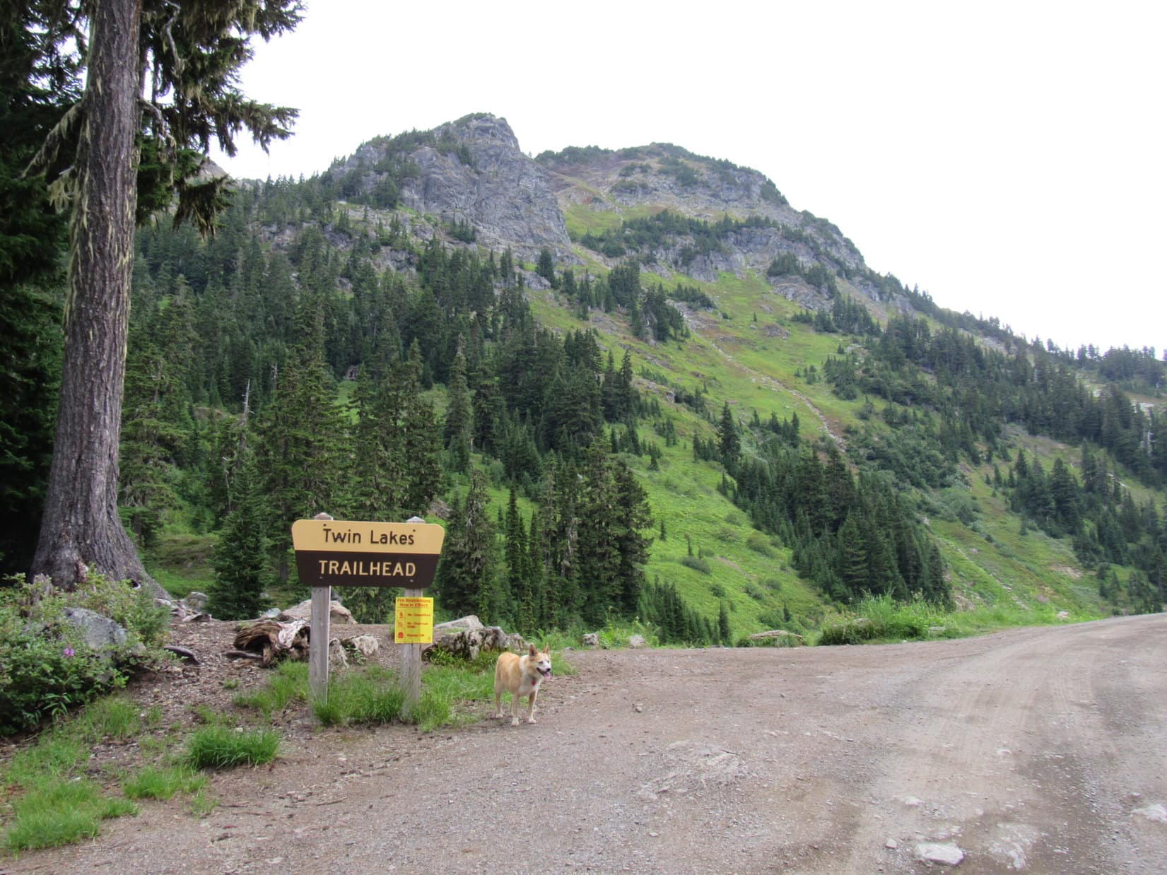
Shortly after starting the 0.75 mile trek N on Red Canyon Road back to the RAV4, a brown and white sign was down in the ditch to the W.

What does this sign say, SPHP?
Well, let’s see, Looper. It says: Deadwood – Custer Cheyenne Stage Route, 1875-1877, Metz Family Massacred Here, April 24, 1875
Massacred! The whole family? Right here, SPHP?
Guess so, or hereabouts. Anyway, that’s what it says, Loop.
That’s terrible! And twice in a row now! I don’t like it.
Twice in a row? What are you talking about?
Don’t you remember, SPHP? Only yesterday, on Expedition No. 293 we came to James Fernando Shepard’s grave. Murdered for a mining claim!
Oh, yeah! That’s right!
I’ve got a bad feeling about this SPHP! Let’s go! It’s a warning!
A warning! The Metz family was massacred even longer ago than poor Mr. Shepard was murdered. Doesn’t have anything to do with us. You’re being ridiculous, Loop!
How can you be so sure, SPHP? What if we’re cursed?
Cursed? Why would we be cursed?
Have I reached 1,000,000 vertical feet of elevation gain yet, SPHP?
Officially? No, but you must be real close to it by now.
How close?
Oh, more than 999,000 feet for sure.
We’re never going to make it to 1,000,000 vertical feet, SPHP! Something terrible is going to happen! We’ve come to a murder, then a massacre. We’re next!
For pity sake, Looper! Get a grip! We’ll be just fine.
It’s been nice knowing you, SPHP. Maybe we should just go home instead of tempting fate?
Oh, no we’re not. We going to the RAV4, then on to the next mountain. Not going to get this close, then quit climbing mountains, curse or no curse! (End 11:25 AM)

The next mountain wasn’t very far away. On the way to it, SPHP stopped for a look at a striking red rock butte capped by a layer of white. Around the next bend, SPHP stopped again to consider a big ridge to the SW.


That’s Peak 4400, Loop! Your next Lists of John peak.
Could have climbed Peak 4400 from the N easily enough, but not without crossing private ranch lands. The American Dingo would have to go for it from the W, where there was USFS access.
11:50 AM, 45ºF, USFS Road No. 316 – Day was half-shot already! Had warmed up nicely, though. Lupe trotted E down No. 316 to the turn by the entrance to the Hey Ranch. Leaving the road, she continued E along a fence to a first little hill on the L, which she then climbed.
Nice view of the RAV4 and forested ridges back to the W from here, but the ridge to the NE was of more interest. Big rocks were along the steep upper rim. Not a problem! Gaps were visible among them. Lupe could get up there easily enough. The American Dingo pressed on.


Once up on top, the view from the ridge was a bit surprising. This was more of a second hill than part of the main Peak 4400 ridge, which was still farther E. Looked like Lupe had started climbing too soon. Might have been better to go around both of these hills before starting up.
Live and learn! A little late for that now!


Deadfall left over from a forest fire made maneuvering difficult. Just took a little time. Soon Lupe was through it, heading down to a saddle that connected with the closest part of the main ridge. After crossing the saddle, another steep climb got the Carolina Dog up onto the W rim.


Except that this wasn’t actually part of Peak 4400’s main ridge, either! Just a third hill. Rinse and repeat! Crossing this third hill, Lupe went down to another saddle leading to yet another climb.
At last, the steep part of the ascent was over. The American Dingo was now up on Peak 4400’s enormous summit plateau, but way out W on a lower part of it near the N end, still 0.5 mile WSW of the true summit. To the E, the terrain still rose, but at a much easier pace. Going over a little rise, a moderately higher part of the plateau was ahead.

The vast plateau was interesting territory. No cactus at all! Lupe liked that. Mostly grassland, but at one time there had been a fair amount of forest up here, too. Nearly all of it had burned.
Looper trotted E, enjoying the sense of elevated spaciousness. Weird rock formations were concentrated near the edge, but also scattered across the plain.
Such strange and wonderful territory, SPHP!
Yeah! This is awesome, isn’t it, Loop? Not many places in the Black Hills like this. Be fun to camp up here on a starry night!


On the upper plateau, Lupe came to a particularly strange formation. It was so cool!

Gently rolling terrain flattened further as Lupe finally drew near the E side of the summit plateau, and was nearly as flat as a pancake by the time she turned N.
The topo map showed the true summit way out near the NE end of the mountain. Did look like there might be slightly higher ground over that way as the Carolina Dog got closer. On the way there, Lupe came to a low region bordered by walls of rock.


Fortunately, the small cliffs along the NW end of the low region were not continuous. Loopster was able to get across. Once on the other side, it wasn’t far to a collection of rocks that appeared to be the true summit of Peak 4400. Located right along the edge of an even larger low region to the NW, this was a very scenic spot!


Of course, on a mountain as flat as Peak 4400, there were other rocks nearby that appeared to be in contention for the title of true summit, as well. Before visiting them, it was time for a break.
Hey, Looper! Why don’t we go find a spot along the NE edge to relax? Should be some pretty sweet views!
Fine with me, SPHP!
1:30 PM, 45ºF, Peak 4400 –
Congratulations, once again, Loopster! Another Lists of John peak climbed!
Two down and one to go! Then my Lists of John mini-blitz will be over, right, SPHP?
Yeah, that’s right, Loop.
Do you think I’ve officially hit 1,000,000 feet of total vertical gain yet?
Not sure. Maybe. If you haven’t, you’re extremely close. No more than 100 or 200 feet away. Might have hit it already. Tell you what. How about we celebrate right now just in case? We’ll split a chocolate coconut bar, and you can have another couple of MarroBones. How’s that?
Not a hard sell. The enthusiastic Dingo made short work of it all, then curled up on SPHP’s lap, crunching Taste of the Wild from her silver bowl, while SPHP munched an apple. The views were splendid!


A peaceful, happy, half hour drifted away.
You know, SPHP, since this is both such a scenic mountain and momentous occasion, we really ought to do some more exploring up here before we have to go!
You’re absolutely right, Loop! Looks like there is still some fun stuff a little farther NW of here. Let’s sniff around over that way for a little bit.


Lupe had a fun time scrambling around among the rocks. Could have spent many hours roaming around up here, but that was not to be. She was a Dingo on a mission. One more Lists of John peak to go!
Starting back, Loopster visited another rock in contention for title of true summit that wasn’t far from the one SPHP actually thought was it.


An hour after arriving, Lupe left the true summit rock for the last time. The angle of the sun warned against any more dilly-dallying. Peak 4400 had been a big, scenic success. Confidence and joy were in the air as the American Dingo worked her way around the NW end of the low region bordered by cliffs again.
And then she saw it.
SPHP, look! The curse! We’re doomed! 1,000,000 vertical feet will be the end of us!
How strange! Lupe had found another rock formation reminiscent of the Dingo Throne. This throne was only a one-seater though, and that seat was occupied. The ruler was right there – a twisted, entirely black tree. A vision of evil!
A death tree, SPHP!

Guess we better say our prayers, Looper! We’re a goner for sure now!
Well, what else could SPHP say? Anyone would know a death tree when they saw one. No denying it! And yet, the nervous Dingo’s return went well overall. Going down the W slope, a promising path led off to the N and got Loop stuck among a giant patch of obnoxious deadfall, but that was the only aggravation. She soon made it down to USFS Road No. 316 somewhat N of the Robinson Ranch.
From there, it was just a pleasant afternoon stroll along the road back to the RAV4. (3:21 PM, 53ºF)

3:51 PM, Dewey Road (Custer County No. 769) – Cows! Despite having barked hysterically at every cow in sight from the G6, and now the RAV4, zillions of times over the years, cows were coming to see Lupe!
Although hesitant, at first, the cows seemed genuinely happy to see the pesky Carolina Dog. They were gathering from all across their huge field. Amazed, Lupe didn’t bark, but stood watching their approach.

Wow, Lupe! Look at this! All the abuse you’ve doled out to them, yet the cows are coming to cheer you on to 1,000,000 total vertical feet! Hear all that mooing? They love you!
Well, it was either that, or perhaps the cows were hoping SPHP still had plenty of chocolate coconut bars to distribute? Who knew? In any case, Lupe was as happy and excited to see all the lovely black cows, as they were to see her.
I’m shocked! You must be right, SPHP! That’s so kind of them. I don’t know what to say. I’m humbled!
Unfortunately, the cows were a bit of a problem. Peak 4440, Lupe’s last Lists of John peak of the day, was in sight beyond their field. Clearly, wandering through a whole herd of cows eager to make the American Dingo’s acquaintance would never do. Furthermore, there was no sign of USFS Road No. 394.2A which was supposed to go due S through this field to USFS land providing the quickest access to Peak 4440.
There was another way, but it would take longer. Better get with it!
Come on, Loopster! Back to the RAV4! We’re going to have to drive a little farther W.
Lupe started to come, but suddenly began limping terribly, hopping about with her L rear paw in the air.
Ow! Ow! Ow! I can’t, SPHP! It’s the curse!
What on earth? What happened, Loop? What’s wrong with you?
I just told you, SPHP! I’m stricken by the murdered, massacred, death tree curse of 1,000,000 total vertical feet! We’re never going to get there! My paw is broken! Oh, it hurts! Ow, ow, ow!
Hold still! Lemme, see that paw, Loop. Uh-huh! How’s that?
Lupe was stunned. An instant cure! Her paw was fine again.
You can remove curses, SPHP? I never knew! All these years you’ve been a wizard incognito? Fantastic disguise, by the way.
Oh, yes! Remove curses all the time! Provided that the curse is that you’ve stepped on a burr.
4:02 PM, 52ºF, Dewey Road, SSW of Walsh Well – Gotta hurry! Getting late on a January afternoon, and Peak 4440 was 1.5 miles SE. And that was just to the base of the mountain. Lupe would still have to climb it!
Onward! Puppy, ho!
As Lupe followed a fence S, a little luck. A walk-in area! The American Dingo could save some time cutting across the big field to the E. No need to go clear around the SW corner to stay on USFS land.


The shortcut brought Lupe to a nearly level plain sloping gradually SE. Peak 4440 was directly ahead, but Lupe was already in shadow. A race against time was on, but some caution had to be used. Scattered patches of large-spined cactus thrived here. SPHP kept an eye out for danger, as Miss Bare Paws made for the mountain.

Discovery of a cactus-free, two-track road, perhaps some remnant of USFS Road No. 391.2A, helped speed things along. When the two-track got close to a wide drainage, Lupe abandoned the road, crossed the drainage, and headed straight for Peak 4440’s NW slopes.


Peak 4440 has two summits, N and S, the N one being highest. The plan was to head up to the saddle between them, then turn N. However, Lupe had started up before going far enough S. This mistake wasn’t evident until she’d already gained considerable elevation. The terrain forced her toward the mountain’s N ridge.
Too late to do anything about it! Just hope it works! The Carolina Dog was already committed, barely keeping up with the last rays of the sun.


The sun was gone by the time Looper reached the N ridge. Twilight was coming on. Amid rocks and junipers, Lupe went up the steep narrow ridge, staying toward the E sometimes, because both the ridgeline and the W slope were just too difficult.

By the time a top appeared, the light was so dim that the camera could barely compensate without producing fuzzy images. Lupe had made it, though! The summit was only seconds away!

5:19 PM, 43ºF, Peak 4440 – Curse or no curse, 1,000,000 total vertical feet, a once in a lifetime achievement, complete! In twilight, Lupe stood atop Peak 4440’s N and true summit. Hard to believe it was over. No doubt at all about it now, though. The American Dingo had done way more than enough.

From the E, a night sky was approaching. To the W, high thin clouds were still on fire, a brilliant orange glow.
Congratulations, Lupe! May I shake your paw? 1,000,000+ total vertical feet! It’s official now. Don’t think too many Dingoes have ever done that!
Offering her sweet little paw, Lupe looked expectantly up at SPHP.
Alright! Yes, I have another chocolate coconut bar for you, but it will have to wait a few minutes. We better get some pictures to commemorate the occasion while we still can.


OK, that’s about it Loop. Thank you!
What a remote and odd little mountain Peak 4440 was! Such an unlikely spot to be celebrating 1,000,000 total vertical feet. Unlikely time of year, too. Almost the end of January? Hardly the heart of climbing season, yet here Lupe was.
In the dying light, two earnest, trusting eyes gazed up at SPHP.

Have I done well, SPHP?
Oh, sweet puppy! Yes! Yes! Yes! You’ve been magnificent all these years! You’re the greatest ever! I love you so much!
Another chocolate coconut bar met its devourer. 2 MarroBones suffered a similar fate. Lupe curled up on SPHP’s lap to watch the world go dark. Far below, cows were mooing, cheering Lupe’s success!


Cows weren’t the only ones cheering for Lupe. Before the first silver stars appeared, suddenly there was a forlorn yipping synonymous with the Old West.
The wild dogs, SPHP!
They must be happy for you, too, Looper!
The coyotes sang to Lupe, but only a few verses before they were done.
6:06 PM – Cows, coyotes, a slight rustling of the wind, but mostly silence, and a million memories. 45 minutes atop Peak 4440, and the universe glittered overhead. Below, a black void. Time to go.


Maybe there really was a curse? Despite the aid of an experienced Dingo guide, and the tiny flashlight, SPHP had a terrible time trying to find the way back down in the dark. Everything was so steep! Nothing worked! Took a long, weary time to get back down to the two-track road well S of where Lupe had left it.
Still more than a mile to go! As crusty snow crunched underpaw, the Big Dipper and North Star showed the way. Cold now. Lupe was tired, SPHP was tired, but it would all be over soon. What a day! (8:17 PM, 22ºF)
2-4-22 – Six days later, SPHP did throw a 1,000,000+ Total Vertical Feet party for Lupe. It was held at Grandma’s apartment, and was she ever surprised! Steve, Xochitl, Felix, and Asher all came. Cake, candles, ice cream, a Busy Rib Hide, and Beggin’ Strips! The whole nine yards! What more could a peakbagging Dingo ever want?


What more could I ever want, SPHP? So glad you asked! Better get some paper and a pencil so you can write it all down. For my 2,000,000 total vertical feet party, I’d suggest …

Links:
Next Black Hills Expedition Prior Black Hills Expedition
Mountains by Sia
Want more Lupe adventures? Check out Lupe’s Black Hills, SD & WY Expeditions Adventure Index, Master Adventure Index, or subscribe free to new Lupe adventures!