Black Hills, SD Expedition No. 244 – False North Point (1-5-19)

Start – 9:46 AM, 38°F along Horse Creek Road (USFS Road No. 243) near USFS Road No. 243.2J

New Year 2019 arrived on a subzero night in the Black Hills.  Things had warmed up since then.  Naturally, Lupe was anxious to get started on her 2019 adventures!  False North Point (6,130 ft.), a peak she had first visited on Halloween in 2015, was going to be her first peakbagging goal of the new year.  She might even make it to Five Points (6,221 ft.) today, with a little luck.

Lupe left Horse Creek Road on USFS Road No. 243.2J.  The snowy road wound S crossing Horse Creek 3 times, but the creek was so small that flowing water was only present on the surface at the middle crossing.  The Carolina Dog easily leapt over it.

Setting out for False North Point on USFS Road No. 243.2J. Photo looks SSW.
Nearing the last crossing of the Horse Creek drainage. Photo looks SSE.

After 0.33 mile, Horse Creek flowed E.  No. 243.2J crossed the drainage for the last time, and began curving SW up another valley.  Lupe came to a locked gate, and went under a barbed wire fence.  A small dry stock pond was just ahead where the valley forked.  No. 243.2J ended here at an intersection with USFS Road No. 669.

Lupe could take No. 669 up separate valleys going either S or W.  She stayed to the R taking the valley to the W.

No. 669 wound W, before eventually turning S.  Looper came to sunny spots, but the road was often in the shadow of forested hills.  At first, 6″ of snow was on the road, but as Lupe gained elevation, the snow became deeper, significantly slowing SPHP down.  Lupe was forced to expend more and more energy bounding through it.

This was a beautiful trek, though.  The snowy valley was quiet and still.  Lupe maintained it could have been improved with the addition of a few squirrels.  She kept a sharp eye and keen nose out, but didn’t find any.

Heading W on USFS Road No. 669.
10 minutes from the stock pond, this gate blocked the road. Lupe went under it. Photo looks W.
The N (R) side of the valley was often sunny, but the road was more apt to be in the shadow of hills to the S (L). Photo looks WSW.
Lupe enjoyed the snowy road trek, but the snow was deep enough to discourage her from spending much time exploring away from the road. Photo looks WSW.
Near this point, No. 669 started curving SW. Lupe saw a small pond and a little creek N (R) of the road here, but the rest of the long valley was dry. Photo looks W.
As the snow deepened, Loop passed some deadfall timber, but there wasn’t much of it most of the way up the valley. Photo looks SW.
The whole valley, but especially this upper part, felt very secluded. Photo looks SSW.

Lupe had been on USFS Road No. 669 several times years ago.  An odd, sublime, sense of both discovery yet vague familiarity, as though having been here before in a dream, took hold.  At last, after 1.75 miles on No. 669, Lupe reached a fork in the road that SPHP definitely recognized.  The snow was belly deep on the American Dingo here.

After 1.75 miles on No. 669, Looper reaches a fork in the road.

Loop took the fork to the L (SE), which very quickly led up to a broad saddle that was also familiar.  This saddle was strewn with a great deal of deadfall timber, the product of a severe pine bark beetle infestation a number of years ago.  Many dead pines had fallen on a barbed wire fence, collapsing it.  SPHP lifted Lupe over the dangerous fallen fence.

On the far side of the saddle, Lupe saw a forested hill ahead.

From the deadfall strewn saddle, Lupe could see a forested hill ahead. Photo looks SE.

SPHP checked the topo map.  False North Point was only 0.33 mile away!  Lupe could head directly for it by turning R and going SSW straight up the hill on the SW side of the saddle.  She could then follow False North Points’ NNE ridge directly to the summit.

Only a low forested hill, and copious deadfall timber, could be seen in that direction.  SPHP carried Lupe back over the collapsed fence.  She then began her ascent of the wretched-looking slope.

Loop still at the saddle. According to the topo map, the low hill beyond her was the way to False North Point, 0.33 mile away. Photo looks SW.

The deadfall was inconveniently laying at a 90° angle to the direction Lupe needed to go.  Her climb began slowly as SPHP laboriously picked a way up through the mess.  Enough trees were still standing to hide any views.  At first, there was nothing to see except the snowy forest.

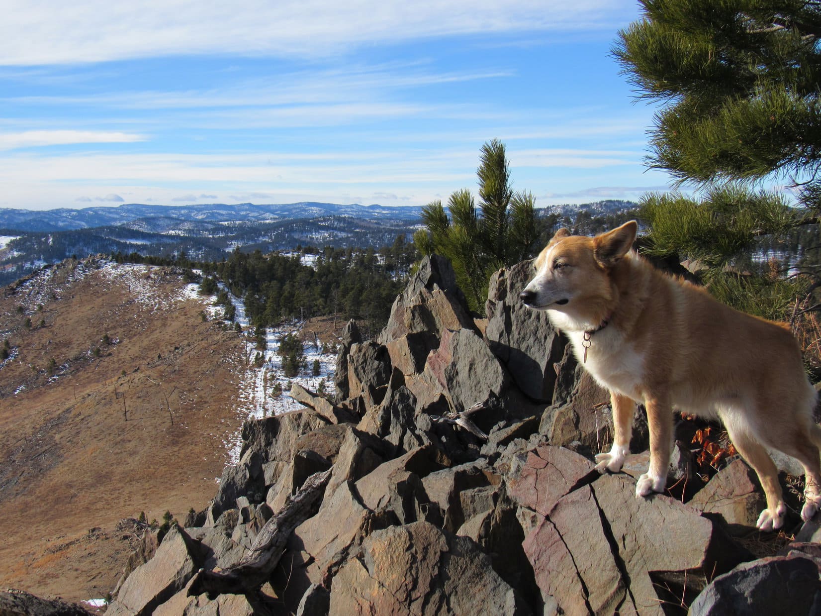
After gaining some elevation, the deadfall thinned out.  Lupe came to a small rock formation from which she had a bit of a view.

Partway up the NNE ridge, Lupe reaches a small rock formation. Photo looks N.

Looper kept going.  The ridge wasn’t particularly steep.  Exploring the forest was fun!  The Carolina Dog had never been up False North Point from this direction before.  She came to another rock formation.  This one had a more impressive view of a wider area.

Exploring False North Points’ NNE ridge. Photo looks SSW.
A better viewpoint higher up. Photo looks NW.

The mountain steepened.  The snow was deeper.  Lupe was getting close to the top.  After toiling up a particularly steep slope, she came to much larger rock formations.  Loopster traveled along the E side of the rocks looking for the summit.

Approaching the steepest part of the climb in deep snow. Photo looks SSW.
Almost there! Lupe along the E side of large rock formations leading to the summit. Photo looks W.
Another look. Same spot.

The last part of the climb was a short scramble.  Lupe arrived at the top of False North Point (6,130 ft.) to find a cramped area of uneven rock.  The summit was a somewhat precarious perch.  Loop had no place to get comfortable or relax.  A small cairn sat upon some of the highest rocks.

The last part of the climb was a very short scramble. Photo looks W.
Success! Lupe stands at the cramped uneven summit of False North Point. Photo looks NNE.

Ponderosa pines hid the views to the SE, but False North Point provided an impressive 180° panorama to the NW.  Lupe could see many peaks she had been to recently off to the N, and a huge expanse of territory off to the W all the way to the limestone plateau country.

Looking NW from the summit. The cairn is in front of Lupe.
Looking NE. Lupe’s hind legs are on the cairn.
Sylvan Hill (7,000 ft.) (L) is the highest distant ridge. Photo looks SSW.
Looking N, Lupe could see many peaks she had visited fairly recently.
The 4 peaks in the foreground are Peak 6,167 (far L), Old Bald Peak (6,130 ft.) (L), Nugget Gulch Peak (6,000 ft.) (Center) and Peak 6043 (R). Photo looks NNW with help from the telephoto lens.
I’d forgotten how amazing these views are from False North Point!

Due in part to these great views, False North Point had gotten its name back on Halloween 2015 when SPHP had mistaken this peak for the northernmost summit of Five Points (6,221 ft.), which was actually 0.5 mile SE.  Lupe had continued on to Five Points that same day, thereby quickly revealing SPHP’s error.

The true north point of Five Points was barely visible from False North Point, almost completely hidden by trees.  SPHP could get a glimpse of it, but Lupe wasn’t tall enough to see it at all.

A glimpse of the true north point (L) of Five Points (R) was all that could be seen from False North Point. Photo looks SE with help from the telephoto lens.

No matter how wonderful the views, Lupe wasn’t going to balance up there on the tippy top of the mountain all day long.  She stayed near the cairn for a short while, before checking out another part of the summit formation 12 feet to the SW.  This wasn’t a much better perch.

Loop on another part of the summit knob. The cairn is out of sight 12 feet beyond her. Photo looks E.
Summit of False North Point from the SW. Photo looks NE.

The summit ridge dropped off quite sharply in most directions.  The SSW spine featured rocks that were flatter and offered essentially the same views.  Lupe headed down there.

Lupe on the spine of the summit ridge. Photo looks SSW.
On a flatter rock SSW of the true summit with an equally fabulous view. Photo looks WNW.

Lupe had arrived at False North Point with enough daylight left to linger here a while.  However, the snow and deadfall had slowed things down enough to make continuing on to Five Points (6,221 ft.) a poor choice.  Conditions were pleasant and the views magnificent, so Loop and SPHP simply relaxed up on False North Point and enjoyed the day.

A happy hour shot by, and it was time to go.

Loop on her favorite perch at False North Point before moving on. Photo looks NNE.

For a change of scene, Loopster headed down the SSW ridge instead of retreating the way she had come.  Below the rocky summit, the ridge was heavily forested, but the Carolina Dog did come to a spot where she had a clear view of Five Points (6,221 ft.).

True North Point (far L), Five Points (L) and Black Elk Peak (7,231 ft.) (R). Photo looks SSE.

Then it was down, down through the snowy woods.  Lupe gradually turned W, then NW.  When the slope began to decrease, she emerged from the forest in a field of scattered pines and deadfall.  USFS Road No. 249 was in sight at the bottom of the slope.

W of False North Point nearing USFS Road No. 249. Photo looks WNW.
Going down the open slope. Photo looks SSW.

Upon reaching No. 249, Lupe followed it N.

On USFS Road No. 249. Photo looks N.

After nearly a mile, Loop reached an entrance to Whisper Creek Ranch, which sounded nice, but was private property.  False North Point was in view to the S from here.

At the entrance to Whisper Creek Ranch. Photo looks NNW.
False North Point from the entrance to the Whisper Creek Ranch. Photo looks SSW.

Thus far, the road had been snow-packed, but beyond the Whisper Creek Ranch entrance a metal gate blocked the rest of No. 249.  That didn’t stop the American Dingo!  Lupe continued N.  No vehicle had been here to compress the snow.

Continuing N beyond a closed gate on USFS Road No. 249. Photo looks N.

Another 0.33 mile, and SPHP figured Lupe had gone far enough N on the road.  She needed to turn E somewhere along in here.  A low bare ridge was E of the road, so Lupe climbed it.  From a minor high point, which SPHP figured was probably High Point 5686, Lupe had her final view of False North Point.

Lupe has a last look at False North Point (L) from High Point 5686. Photo looks S.

The Carolina Dog left High Point 5686 going N, but soon turned down into the valley to the E.  She had never been here before, so exploring this new valley was interesting.

Exploring the valley NE of High Point 5686.

The valley eventually led back to USFS Road No. 669, somewhat below the fork in the road where Lupe had gone L to reach the saddle NNW of False North Peak.  From here on, Loop simply retraced her route up all the way back to Horse Creek Road.  (4:17 PM, 33°F)

Only later did SPHP realize that Lupe’s snowy return to False North Point had been exactly 100 Black Hills Expeditions after her very first ascent on Expedition No. 144 way back in 2015.  Perhaps she will return again some fine day, 100 expeditions into the future?

False North Point was pretty fun! Maybe I’ll be back on Expedition No. 344? Hope to see you again here at The (Mostly) True Adventures of Lupe before then, though!

Links:

Next Black Hills Adventure                 Prior Black Hills Adventure

Want more Lupe adventures?  Check out Lupe’s Black Hills, SD & WY Expeditions Adventure Index, Master Adventure Index, or subscribe free to new Lupe adventures!

Black Hills, SD Expedition No. 243 – Peak 5917 & Pistol Point with Uncle Joe & Cousins Dusty & Mark (12-22-18)

Lupe was delirious with delight!  The shocking news SPHP had just given her was so incredibly wonderful!  Why, Christmas was coming!  Not only that, but Cousin Dusty and Uncle Joe were in town all the way from Colorado.  Cousin Mark had even come with them.  They all wanted to go on a Black Hills Expedition with Loop.  Nothing too fancy or long, but enough to get a workout and see a few sights.

Was the American Dingo up for that?  Oh, boy!  Was she ever!  She barked and leapt at SPHP.  What’s the holdup?  Let’s go right now!

Loopster raced through the front door of Grandma’s house and greeted everyone with great joy and energy.  It was true!  They were all here!  Dusty was instantly excited, too, and responded in kind.  Greetings all around.  Dusty and Lupe both looked at SPHP expectantly.  Oh, yeah.  They both knew that Grandma had a big bag of Beggin’ Strips downstairs.  Of course, they each got one.  Sly dingo Loop grabbed two.

Start – 9:51 AM, 27°F at the junction of Highway 385 & USFS Road No. 710

Kind of cold and snowy, but this was a good spot for a quick romp in the hills.  Peak 5917 was only a little more than a mile away.  Several options from there depending how things were going.  With minimal delay the whole gang started up No. 710.  The road headed W up a shady valley N of Peak 5800.  Cousin Dusty led the way.

Setting out for Peak 5917 on USFS Road No. 710. Uncle Joe with Cousin Dusty. Cousin Mark with Lupe.
Cousin Dusty leads the way.

After 0.75 mile on No. 710, the road reached the upper end of the valley.  The terrain flattened out.  No snow here.  The road curved S passing through an open stand of tall Ponderosa pines.

Lupe’s entourage reaches the open stand of Ponderosa pines at the upper end of the valley. Photo looks SW.

Beyond the pines the road turned W again, and began to fade.  Ahead was a region of grasslands dotted with scattered pines.  Peak 5917 was already in sight.

Beyond the tall pines, heading for Peak 5917 (R). Photo looks W.

Soon everyone was on the way up Peak 5917’s SE slope.  Mark and Dusty were out in front.

Cousins Mark & Dusty led the way up.
Joe pauses to look back. The tall pines are at the far edge of the grasslands beyond him. Peak 5800 is on the R. Photo looks ESE.

Mark and Dusty reached the summit well before Joe, Lupe and SPHP caught up.

Cousin Mark atop Peak 5917. Mark is a Dance Dance Revolution champion who competes in tournaments. No wonder he was stepping so lively!
Joe and Dusty join Mark at the summit. Photo looks N.
Mark & Joe at the summit of Peak 5917. A triumph of sorts. They’re from Colorado. Maybe they’ve been on an even loftier peak once or twice before? Part of Pactola Reservoir (R) is in the background. Photo looks NNE.
Lupe’s turn on the highest rocks while getting a pat from Mark. New Year’s Eve Peak is in view beyond her. Photo looks W.

December.  Not especially cold, but definitely cool out.  A chilly breeze was blowing out of the W.  Prior to leaving Peak 5917, a group photo was hastily arranged.

L to R – Mark, Dusty, Lupe & Joe. Five Points (6,221 ft.) is a little L of Mark, and conical False North Point (6,130 ft.) is R of him. Pistol Point (5,880 ft.) is at the far end of the half grassy, half forested ridge on the R. Photo looks SW.

What now?  Was everyone done?  The closest options for extending the trek were New Year’s Eve Peak (6,046 ft.) a mile NW as the ridges went, go only halfway there to Pistol Point, or head SE back to Peak 5800.

Pistol Point sounded good to everyone.  Mark, Dusty and Joe started down Peak 5917’s SW slope.  Loop lingered briefly at the summit before following after them.

Looper lingers in the chilly W breeze atop Peak 5917. New Year’s Eve Peak (L) in the distance. Lupe had been there only 5 days ago on Expedition No. 242. Photo looks NW.
Mark, Dusty & Joe start down the SW slope. Black Elk Peak (7,231 ft.) (L), Five Points (Center) and False North Point (R) are all in sight. Photo looks SSW.
Pistol Point is at the far end of the half grassy ridge on the L. Photo looks W.

Pistol Point is only 0.5 mile SW of Peak 5917.  Cousin Mark was soon poised atop the rocky ridge.

Heading up to Pistol Point. Photo looks W.
Mark poised atop the rock formations at Pistol Point while Joe takes a photo. Lupe is standing over near the rock resembling the handle of a pistol jammed into the ground that Pistol Point is named for. Photo looks ENE.
Cousin Mark staying hydrated.
Mark and Dusty relax for a moment taking in the views. Photo looks SE.
Joe and Lupe take a turn up on the rocks. Photo looks W.

Pistol Point offers the same sweeping 180° views to the S that Peak 5917 does from only a slightly different perspective.  The W wind was still chilly.  If it hadn’t been for the breeze, New Year’s Eve Peak, only 0.5 mile NW, probably would have happened.

As it was, though, Cousin Dusty was shivering.  At 12 years old, she was doing great to have come this far leading the way most of the time.  Best to head back, though, to get her out of the cold wind.

Group photo at Pistol Point shortly before departure. Mark and Lupe on the L. Joe and Dusty on the R. Photo looks SW.
Peak 5917 from Pistol Point. Photo looks NE.
Joe and Dusty start down. Peak 5917 (L) and Peak 5800 (R). Photo looks ENE.

Dusty felt better as soon as she was out of the wind.  The trek back to the G6 was scenic with great company to share the day with.  The route back was the same, minus an excursion up to Peak 5917 again.

Dusty leads as Mark and Joe follow her down. Peak 5800 (R). Photo looks ENE.
A momentary pause while Joe checks his phone. Part of Sheridan Lake is seen beyond Dusty.  Calumet Ridge (5,601 ft.) is beyond the lake. Silver Mountain (5,405 ft.) is L of Calumet Ridge. Photo looks SE.
Another pause on the return. Peak 5800 (Center). Photo looks ESE.
Lupe in familiar territory. Nearly every year she makes a pilgrimage to New Year’s Eve Peak coming this way. Boulder Hill (5,331 ft.) (R) is the prominent knob far beyond her. Peak 5800 (L). Photo looks SE.
Dusty having a good time in the Black Hills now that she’s out of the wind.
Back on the road in the tall pines area. Photo looks E.

Before long, everyone was heading down the valley on snowy USFS Road No. 710.  A ride back to Grandma’s house for goodies and more fun was waiting at the end of the road.  Best of all, the festivities would continue for the next several days, because, you know, Christmas was coming!  (12:52 PM, 29°F)

Mark, Joe, Dusty & Lupe on USFS Road No. 710, Black Hills of South Dakota 12-22-18

Links:

Next Black Hills Expedition                   Prior Black Hills Expedition

Want more Lupe adventures?  Check out Lupe’s Black Hills, SD & WY Expeditions Adventure Index, Master Adventure Index, or subscribe free to new Lupe adventures!