Cloud Peak, Bighorn Mountains, Wyoming – Part 2: Paint Rock Creek Falls Base Camp to the Summit (7-20-16)

Light out.  Looked like for a while already.  Ugh!  Loopster, you awake?  Of course, she was, but even Lupe wasn’t looking too lively yet, still content to snuggle down on her sleeping bag.  Lupe gazed sleepily back at SPHP.  Is it time?

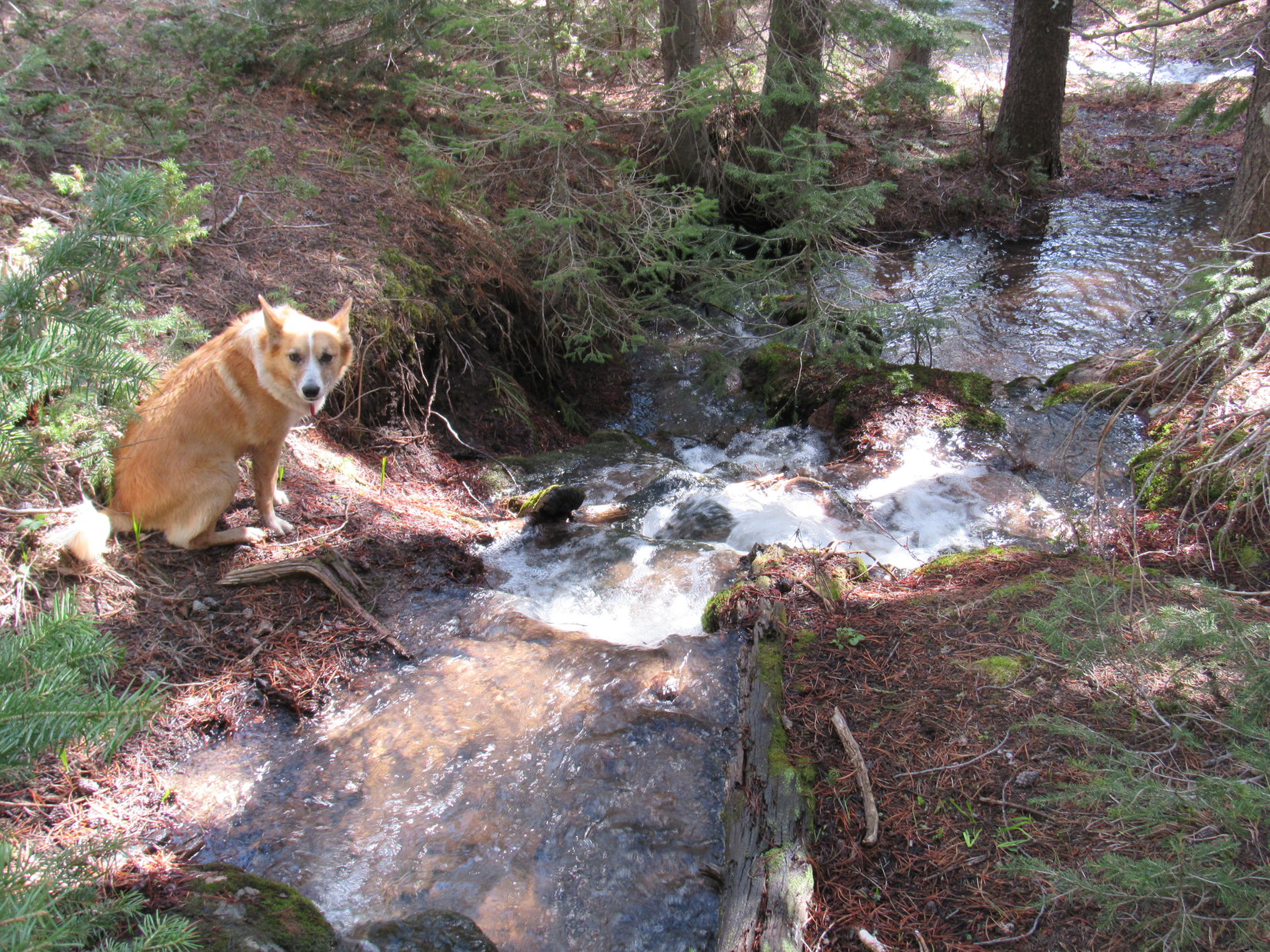
Uncharacteristically, Lupe had only wanted to go outside her “tiny house” once during the night to prowl around.  The scene, the mood, had been magical.  A full moon flooded Paint Rock Creek valley with ghostly light.  Close by, but out of sight below the grassy ridge on which Lupe’s tiny house was perched, came the soothing sound of Paint Rock Creek gushing over a 15 foot high waterfall.  Otherwise, silence prevailed beneath the night sky.  Nothing stirred.  Lupe and SPHP were utterly alone.

Now it was light out.  Yes, it’s time, Loop.  I wish it wasn’t – I’m not feeling it.  Sheesh, why do I always do this?  Bomber Mountain after Cloud Peak, indeed – what a joke!  I must be delusional.  Now I’ll be lucky to drag myself up Cloud today.  I hope you’re more ready for this than I am.  SPHP started preparations for the day’s climb.  Lupe watched, but didn’t move.  She made no comment.

Yesterday, Lupe and SPHP had made it from the trailhead at West Tensleep Lake to the junction of the Misty Moon Trail (No. 63) and the Solitude Trail (No. 38) SW of Misty Moon Lake in good time.  The sun had still been high overhead.  Lupe and SPHP could have made it to base camp on the ledge near Paint Rock Creek falls with many hours before sunset to relax and recuperate for the climb up Cloud Peak (13,167 ft.) today.

Hah!  That would have been too easy.  Instead, full of enthusiasm, SPHP had led Lupe E on the Solitude Trail off on a side excursion to see the Fortress Lakes and Gunboat Lake.  Lupe even left the trail to climb a minor high point, Peak 10,860.  From there, SPHP had seen what looked like a good route up Bomber Mountain (12,840 ft.) from the Florence Pass area.  Wouldn’t it be fun for Lupe to climb Bomber Mountain, too, the day after climbing Cloud Peak?

The side excursion was fun and beautiful, but also chewed up lots of time.  More importantly, it used up a lot of energy.  As a result, Lupe and SPHP had dragged into base camp on the low ridge NW of Paint Rock Creek falls only an hour and a half before sunset.  By then, the Bomber Mountain daydream was shattered.  SPHP was played out.  Even Lupe seemed tired.  As soon as Lupe’s tiny house was pitched, Lupe and SPHP had crawled inside and crashed.

OK, Loop, let’s go!  Yeah, yesterday’s side excursion may have been a mistake, but so what?  You’re gonna make it to the top, sweet puppy!  We still have lots of advantages.  We are starting from the best and closest possible base camp, the weather is ideal, and we saw yesterday that there’s almost no snow left up there to stop us.

Not gonna set any speed records, unless it’s for the slowest ascent ever, but who cares?  No one.  It’s just us.  We have all day.  We can rest as often and long as we want to.  There’s a reason for this SPHP tag, you know.  Even so, this is still going to be a glorious day.  Promise!

Lupe and her tiny house at base camp near Paint Rock Creek ready to leave for Cloud Peak. Photo looks NE.

Lupe was ready!  She grabbed a big stick and chomped it.  She snarled and barked.  She leaped around encouraging SPHP to please, finally, get on with it.  And then she was off, tearing NE along the trail up Paint Rock Creek valley above the falls.

The unmaintained trail was good, at first.  It paralleled Paint Rock Creek from a short distance to the NW.  Lupe and SPHP went down to the creek, so Lupe could get a drink.  Bluebells were growing in profusion along the banks.

Bluebells along Paint Rock Creek.

Lupe and SPHP returned to the trail.  Almost immediately, it veered N, leaving the creek behind.  Gradually, the trail became more intermittent and harder to follow.  Sometimes there were cairns to show the way.  There was no reason to worry.  It was just about impossible to get lost.  To the N was a giant ridge of solid stone sweeping up to the NE toward Cloud Peak’s summit.

Lupe and SPHP came to several big rock formations that had to be traversed.  Between the formations was much more level grassy ground.  SPHP grew careless about following the trail, losing it several times.  Lupe kept coming across it again.  Once, at one of the formations, Lupe came to a rock wall that was too high for her to scramble up.  SPHP lifted her up, but that was the only time she needed help.

One of the first grassy areas Lupe crossed after leaving Paint Rock Creek. Cloud Peak is glimpsed in the distance to the L of the prominent point at Center. Photo looks NE.
Lupe on her way up one of the rock formations. The trail went to the L of where Lupe is standing, not up the rubble filled ravine on the R.

Sometimes Lupe had to lose a little elevation leaving the rock formations to reach the next grassy section, but the elevation loss was never significant.  The last grassy section was the largest of all.  Several ponds were scattered around.  Directly ahead, beyond the grass, was a headwall.  Above it was a higher valley leading toward Cloud Peak.

The last, and largest, of the grassy sections between rock formations is seen ahead. On the L is the headwall, above which is an upper valley between the huge ridge on the L and the prominent point at Center.

After crossing the last big grassy area, Lupe was delighted to discover a big patch of snow in a cleft in the headwall.  She frolicked, slid, and rolled on it.  SPHP was happy for her.  Down on the sagebrush prairies surrounding the Bighorns it was supposed to be 100°F, but here was Lupe having a blast in the snow!

Lupe having fun on the first snowbank she encountered.

Above the headwall, the long upper valley stretched ahead.  There was a fair amount of grass in the center of the valley.  A tributary of Paint Rock Creek cascaded down from above.

Lupe reaches the top of the headwall. Behind her is the long upper valley extending away to the NE.

SPHP hadn’t really bothered to look for the route the intermittent trail took up over the headwall, but realized Lupe was probably SE of it.  The center of the valley near the creek looked like the easiest way up.  Unfortunately, instead of immediately working over to the middle, SPHP chose what looked like the easiest route from where Lupe had arrived on the headwall, which stayed SE of the valley center.

The route was full of boulders, but now and then there were short stretches of grass or dirt.  They all led higher up on the SE side of the valley.  Gradually, Lupe was getting farther away from the middle of the valley, instead of closer to it.  Lupe didn’t seem to mind all the rock-hopping too much, but for SPHP it was time consuming and exhausting.  Frequent stops were necessary to let heart and lungs catch up.

Lupe on the boulders up on the SE side of the upper valley. Lupe was doing OK, but for SPHP progress was tedious.

Eventually, Lupe was a long way up on the SE side of the upper valley.  By now, even short stretches of grass or dirt were non-existent.  Ahead was a seemingly endless boulder field.  Somewhere up there, SPHP knew Lupe would arrive at the edge of massive cliffs to the SE.

From below, the boulders above repeatedly gave the impression that Lupe was nearing the top of the ridge.  As Lupe scrambled ever higher, SPHP urged her to be careful.  However, each time Lupe reached the apparent ridgeline, all that was revealed beyond were more boulders and an even higher ridge.

Lupe nears the top of one of the false ridgelines. Beyond, all that was revealed was another long climb to a similar, even higher, false ridgeline. Photo looks E.

Slowly, Lupe and SPHP pressed onward and upward.  There was no other reasonable choice.  The floor of the upper valley was now much too far below to consider going back down looking for a better route.  Sorry, Lupe, looks like I’ve really screwed this up again.  We’re still going to make it, though.  This can’t go on forever.  On the way back down, we will find a better way.

By now, even Lupe was getting sick of all the rock hopping.  Each time SPHP stopped for a breather, she curled up at SPHP’s feet as best as she could.  SPHP tried to stop at tiny patches of grass, so she could be somewhat comfortable, but often there wasn’t anything resembling “comfortable” around.

Photo of the day! Want to know what climbing Cloud Peak is like? This is it! SPHP could have taken 1,000 photos looking like this one on the way.

Despite the horrible route SPHP had selected, there were still cairns scattered around here and there.  They were utterly meaningless.  SPHP did derive a little comfort from them.  Well, Loop, looks like we aren’t the only suckers to ever come this way!

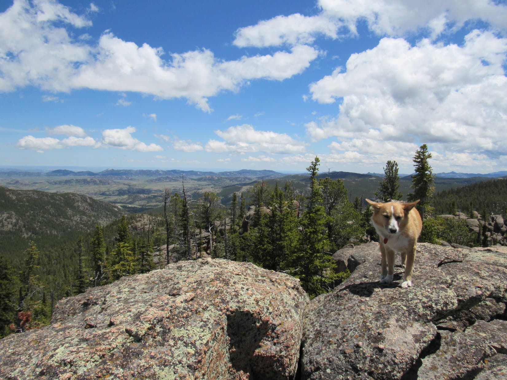
Over time, SPHP could see Lupe was making progress.  She was gradually gaining on Elk Mountain (11,321 ft.), far off to the SW.  After a while, she was even with it.  Eventually, Elk Mountain was clearly below Lupe’s elevation.

At last, Lupe reached the edge of the cliffs!  Across a chasm to the ESE was an impressive view of Bomber Mountain (12,840 ft.).  To the NNE was Lupe’s first relatively close up view of “The Bridge”.  It was farther away than SPHP had hoped.  The entire intervening distance was still nothing but more boulders.  Beyond “The Bridge”, boulder fields rose 1,000 feet above Lupe’s current position.

Lupe reaches the edge of the cliffs. Bomber Mountain (12,840 ft.) is seen on the R. Lupe is somewhere very near the point marked 12,152 ft. on the Peakbagger.com topo map. Photo looks ESE.
Lupe at the edge of the chasm. "The Bridge" is in view on the skyline directly above Lupe. Photo looks NNE.
Lupe at the edge of the chasm. “The Bridge” is in view on the skyline directly above Lupe. Photo looks NNE.

What SPHP refers to as “The Bridge” is a narrow band of rock connecting much wider portions of the long SW ridge leading up to the summit of Cloud Peak.  If “The Bridge” didn’t exist, Cloud Peak would be a technical climb, the summit attainable only by those with genuine mountaineering skills and equipment.  Casual day hikers and backpackers like Lupe and SPHP would have no way to ever reach the summit.

Lupe and SPHP had no choice, but to continue on to “The Bridge”.  Lupe went N over the boulders along the edge of the chasm to the E.  As she got closer to the narrowest part of “The Bridge”, Lupe turned NE to cross it.  There were huge drop offs on both sides, with spectacular views, but “The Bridge” is plenty wide enough so that crossing it under favorable conditions isn’t a terrifying experience.

Lupe near the start of "The Bridge" before crossing it. Lupe got to this point coming up from the R to reach the edge of the near ridge seen above her in this photo. She then followed the edge up. This was not a good route. SPHP should have stayed to the R of this photo all the way up, so Lupe could arrive directly at this point from the R. Photo looks SSW.
Lupe near the start of “The Bridge” before crossing it. Lupe got to this point coming up from the R to reach the edge of the near ridge seen above her in this photo. She then followed the edge up. This was not a good route. SPHP should have stayed to the R of this photo all the way up, so Lupe could arrive directly at this point from the R. Photo looks SSW.
Lupe crossing "The Bridge". The W high point of the Cloud Peak summit area looms another 600 or 700 feet higher ahead. Photo looks NE.
Lupe crossing “The Bridge”. The W high point of the Cloud Peak summit area looms another 600 or 700 feet higher ahead. Photo looks NE.
Looking NW from “The Bridge”. Lakes W and NW of Cloud Peak are in view. The highest point seen beyond them is Peak 12473.
The same lakes using the telephoto lens for a better look at the waterfall. Photo looks NW.

While crossing “The Bridge”, Lupe gained little net elevation, if any.  The crossing was still slow, since “The Bridge” is all boulder field, just like the rest of the terrain.  There appeared to be a somewhat easier route toward the S side, but naturally, SPHP had led Lupe along the N edge to see the views in that direction.  Was it possible to go any slower?  It was hard to see how.

Beyond “The Bridge”, Lupe resumed her climb.  Only another 600 or 700 feet of elevation gain to the top!  Only?  SPHP was fading.  Lupe wasn’t, though!  There were many places where SPHP thought the Carolina Dog might need help over huge boulders.  Each time SPHP offered to lend her a hand, though, all on her own she appeared a moment or two later grinning down at SPHP from above.  Show off!

This high on the mountain, Lupe started coming to more snow.  The snow actually helped.  SPHP was able to trudge right on up it, where the snow wasn’t too steep.  Although it was warm out and the snow was melting at a good clip, it didn’t give way.  Crossing the snow was much faster than trying to negotiate the boulders.

Getting there!
Getting there!

Finally, less than 500 feet below the summit during one of SPHP’s innumerable rest breaks, SPHP saw something that had been expected for hours.  Below, and not terribly far away, someone was coming!  Two people and a white dog!  They were moving fast.  Soon they would overtake Lupe and SPHP.  Until now, Lupe and SPHP had been totally alone on the mountain.

Before long, Lupe and SPHP met Garrett, Ariel, and their dog Apollo!  They were from Casper, WY.  After a pleasant few minutes chatting, Lupe and SPHP were left behind.  Garrett, Ariel and Apollo blazed ahead, eventually disappearing high above.  Lupe and SPHP plugged along slowly.  At long last, from the SW, Lupe reached the summit area.

The summit area was quite large – a few hundred feet across or more.  The whole area was still all boulder fields, but they sloped much less dramatically.  There was a high point to the W, which had been visible at times on the way up.  The true summit was a large boulder with a cairn on it off toward the E edge of the mountain.  Huge precipices were to the E and S near the true summit, and W of the W high point.

Garrett, Ariel and Apollo were still at the true summit when Lupe and SPHP finally arrived.  Lupe was more than a little ill-mannered toward poor unoffending Apollo.  Apparently, SPHP had been moving so slowly, Lupe had spent enough time on Cloud Peak on the way up to start thinking of the mountain as her own territory.  Lupe repeatedly growled warnings at Apollo.  This mountain isn’t big enough for the two of us!

Come on now, Lupe, of course it is – behave!

This was it!  Success!  Despite the perfect weather, no one else was coming to climb Cloud Peak today.  Garrett and Ariel said it was already 3:15 PM.  (Good grief, had it really taken SPHP 8.25 hours to struggle up this mountain?  A lousy 3,000 feet of elevation gain from base camp?  Apparently so.  Record crappy ascent time secured!  No matter, it was still a successful ascent.)  Time for everyone to celebrate with a few photos!

Lupe on top of Cloud Peak with Ariel, Garrett & Apollo from Casper, WY.
Ariel and Garrett at the summit. Photo looks S.
Garrett, Ariel & Apollo. SPHP believes the highest of the nearby sharp points in the background are Black Tooth Mountain (13,005 ft.) and Mt. Woolsey (12,978 ft.). Photo looks N.

Garrett and Ariel stayed up at the summit talking with SPHP.  They were trail runners, and spent quite a bit of time in the mountains when they could.  They had only 2 days off work, and had come up to the Bighorns just to tag Cloud Peak.  Amazingly, they had hopes of being down off the mountain and back to Pizza Hut in Buffalo, WY before it closed at 10 PM!

It seemed impossible!  SPHP would be thrilled with stumbling back into Lupe’s base camp before it was pitch black.  SPHP talked with Garrett and Ariel so long, they probably never stood a chance of enjoying that pizza.  It was after 4 PM by the time Garrett, Ariel and Apollo took their leave, and disappeared off to the SW.

Alone again, Loop!  What a glorious place!  We did make it, didn’t we?  Lupe panted happily at SPHP.  Sure did!  You knew we would!  You’re with an American Dingo.  It was in the bag all along.  SPHP sat petting Lupe on the summit boulder for a while.  Yeah, but you gotta remember, I’m no American Dingo.  Lupe sighed and rolled over, paws in the air.  Good!  You can scratch my belly, then.  SPHP complied, while surveying the world from 13,167 ft.

Lupe stands alone on the Cloud Peak summit boulder. Photo looks SE toward Bomber Mountain.
Looking W toward the W high point. From the true summit, it looked nearly as high. However, when Lupe and SPHP went over to check it out, it was readily apparent the E boulder with the summit cairn was most definitely the true summit.
Looking E down on Glacier Lake.
Looking SSE along the spine of the Bighorn Mountain range.
A look at a forest fire to the NNW with help from the telephoto lens.
Looking SW back down the mountain. Lake Helen and Misty Moon Lake are in view below, as well as Elk Mountain (11,321 ft.) on the R.
Lupe at the W high point. Photo looks WNW.
Looking N from near the W high point. SPHP believes Lupe's ear seen on the L is pointing up at Black Tooth Mountain (13,005 ft.). Her ear seen to the R is pointing up at Mt. Woolsey (12,973 ft.).
Looking N from near the W high point.  Lupe demonstrates proper soft dingo ear positioning technique.  SPHP believes Lupe’s ear seen on the L is pointing up at Black Tooth Mountain (13,005 ft.). Her ear on the R is pointing up at Mt. Woolsey (12,973 ft.).
Seen from the N in this photo, Cloud Peak's W high point looks very different than when viewed from the E.
Seen from the N in this photo, Cloud Peak’s W high point looks very different than when viewed from the E.
Looking W. A small portion of Middle Cloud Peak Lake is in view (L), as well as most of a long unnamed lake NE of it (R).

It must have been approaching 5 PM, by the time Lupe and SPHP started back down.  Going down was easier, but still ridiculously slow.  SPHP did improve on route selection, which in some places made virtually no difference, but in others helped tremendously.

The big improvements came below “The Bridge”.  This time, Lupe stayed much farther to the N, heading W from “The Bridge”.  This eventually brought Lupe down to a big, nearly flat area that swept off to the S and then down around to the SW.  There were so few boulders here, that Lupe was free to run around exploring as she pleased.  It was like a Cloud Peak super highway compared to the way Lupe and SPHP had struggled up earlier!

Lupe on her way down, but still not far from the top. "The Bridge" can be seen above her head. On the far side of "The Bridge", going to the R down toward the big patch of snow brought Lupe to the Cloud Peak version of a superhighway. She actually reached the flats a little to the L of the patch of snow. Lupe perked up considerably when she was finally free of the boulder fields, and could actually roam and run again. Photo looks SW.
Lupe on her way down, but still not far from the top. “The Bridge” can be seen above her head. On the far side of “The Bridge”, going to the R down toward the big patch of snow brought Lupe to the Cloud Peak version of a super highway. She actually reached the flats a little to the L of the patch of snow. Lupe perked up considerably when she was finally free of the boulder fields, and could actually roam and run again. Photo looks SW.
A closer look at "The Bridge" (on the L) from above. Photo looks SW.
A closer look at “The Bridge” (on the L) from above. Photo looks SW.

Better route selection hardly mattered at first.  It took a long time just getting down to “The Bridge”.  The scenery was spectacular, though!

Another peek at the forest fire to the NNW.
An evening shot of the lakes to the W.
Cliffs along the W face of Cloud Peak. Photo looks NNE.
Nearing "The Bridge" from above. Photo looks SW.
Nearing “The Bridge” from above. Photo looks SW.
W face of Cloud Peak from near "The Bridge". Photo looks NE.
W face of Cloud Peak from near “The Bridge”. Photo looks NE.

By the time Lupe reached the Cloud Peak super highway, the sun was already very low, and the light was beginning to fade.  It was still a very long way back to Lupe’s base camp.  Fortunately, Lupe and SPHP could now make rapid progress for a while.

The big flat area gradually steepened, and eventually led down into the upper end of the valley above the headwall where the tributary of Paint Rock Creek was flowing.  There were lots more boulders again here, but Lupe was able to avoid most of them.  Successive trails marked by cairns went down long stretches of narrow, boulder-free paths of dirt or grass.

As Lupe got close to the stream, she found a lot more grass, plus big areas of relatively smooth exposed bedrock.  Staying on the SE side of the stream, but close to it, was a lot better than Lupe’s tortuous climb among the boulders higher up on the SE side of the valley in the morning.

As fast as Lupe’s progress was, by the time Lupe and SPHP managed to get down the headwall to the biggest grassy area with scattered ponds, the sun was long gone.  Twilight was fading fast.  Beyond the grass, SPHP had a hard time finding a decent route over the first of the rock formations that had to be traversed.  Once on the other side, nothing looked familiar, not that it was possible to see much.

SPHP brought out the flashlight and a headlamp.  Ahead to the SW, a wide valley of exposed bedrock sloped down into a deep dark hole.  Off to the SE was the outline of a dark ridge, but it wasn’t nearly high enough to be the ridge S of Paint Rock Creek.  Confusion set in.  SPHP couldn’t see much, but what was in view seemed wrong.

Did the map show the dark ridge to the SE?  SPHP didn’t remember it from earlier in the day.  A look at the topo map didn’t seem to show it either.  Was it possible to miss going right by Lupe’s base camp by simply continuing down the canyon?  Both the map and what SPHP could remember seemed to indicate that was impossible, yet the yawning black hole ahead looked totally unfamiliar.

Lupe, let’s go back up a way, maybe we are supposed to be on the other side of this dark ridge to the SE?  Lupe was fine with that.  For a few minutes, Lupe and SPHP headed back up to the NE.  Reason soon set in again.  SPHP stopped.  Let’s have another look at the topo map.

Little bulges to the SW in the topographic lines probably indicated the presence of the dark SE ridge.  SPHP probably hadn’t paid any attention to the ridge in the morning, because it wasn’t really as big as it looked in the dark.

Loop, we are turning around again to go back down into the dark hole.  If we persist in trying to reach the other side this SE ridge, we may find ourselves in a real jumble down along Paint Rock Creek way before it reaches the trail.  Keep an eye out for the trail, and sniff around for it, too.  We need to find it!

Cautiously, SPHP headed back down toward the dark abyss.  Lupe sniffed around.  She found the trail!  It was faint, but here was a little cairn.  This had to be it.  Across the grassy areas and over the rock formations, Lupe helped SPHP stay on the trail.  It had been intermittent and kind of hard to follow in the day.  In the dark, it was really tricky.

Whenever the trail disappeared, SPHP watched Lupe, in a minute or two she was usually on it again.  Several times SPHP disagreed with Lupe on which way to go.  Lupe was soon proven right almost every time.

The rock formations seemed much steeper and rougher in the darkness than during the day.  The way back seemed much longer than expected, too.  Darkness does that.  Time passes much more slowly than one thinks.  SPHP went on and on in the darkness, but with growing confidence.  The little cairns were helpful.  Lupe was helpful.  The trail gradually improved.

Finally, Paint Rock Creek could be heard not too far away.  The trail still didn’t go toward it for what seemed like a long time.  Eventually it did, though, and not long afterward, Lupe arrived back at her tiny house.  Ta da!  That was quite a day, Lupe!  Thanks so much for your help!  We are going to remember Cloud Peak for a long time.  Hungry?

Lupe was hungry.  Famished, actually.  She had hardly eaten anything all day.  She inhaled her Taste of the Wild.  Then she was ready to curl up on her sleeping bag.  SPHP pulled part of it over her.  Keep the puppy warm!  Lupe was asleep in no time.  SPHP was too weary to eat.  Out like a light.

Suddenly, it was morning again.  Bright and beautiful, but not a cloud in the sky.  It was going to be a scorcher, even way up here.  Now it was SPHP’s turn to eat.  Lupe hardly stirred, happy curled up on her sleeping bag.  SPHP wrapped it around her a little better again.  Hope you weren’t too cold in the night Loop, I never regained consciousness to check on you.

So do I win an "I survived Cloud Peak" T-shirt or anything for yesterday's exploits?
So do I win an “I survived Cloud Peak” T-shirt or anything for yesterday’s exploits?
Looking S across Paint Rock Creek valley from Lupe's base camp. Lupe would have to follow the Solitude Trail over the low pass on the L to Misty Moon Lake on her way back to the trailhead at West Tensleep Lake.
Looking S across Paint Rock Creek valley from Lupe’s base camp. Lupe would have to follow the Solitude Trail over the low pass on the L to Misty Moon Lake on her way back to the trailhead at West Tensleep Lake.

Well, Loopster, Cloud Peak was your toughest peakbagging success yet, but it’s time to go home today.  We are low on water, and even if we had gallons of it, I am totally out of energy to climb Bomber Mountain.  That was pure fantasy for this trip.  Not going to happen.  It wasn’t in the original plan, anyway.  Would you like to explore the ridge to the W for a little way, though, before we leave?

Lupe was fine with sniffing around to the W.  She climbed some low hills.  She saw a beautiful unnamed lake.  She drank from a tiny stream.  SPHP admired Paint Rock Creek valley, and all the wonderful sights in and around it.

The hidden lake W of Lupe's base camp. Photo looks W.
The hidden lake W of Lupe’s base camp. Photo looks W.
Looking back E up the Paint Rock Creek valley from the farthest point W on Lupe's morning exploration. Cloud Peak is seen on the horizon on the L.
Looking back E up the Paint Rock Creek valley from the farthest point W on Lupe’s morning exploration. Cloud Peak is seen on the horizon on the L.

Lupe and SPHP returned to base camp.  It was time to go.  SPHP took down Lupe’s tiny house.  Away went Lupe and SPHP, S across Paint Rock Creek valley, up the other side to the Solitude Trail, and over the pass.  Lupe went by Misty Moon Lake, reached the Misty Moon Trail, and proceeded S past Lake Marion and Lake Helen.

Misty Moon Lake from near the Solitude Trail. Photo looks S.
Lupe with a sly look on her face near Lake Marion. Photo looks S.

At 4:14 PM (81°F), Lupe’s 3 day/2 night adventure to Cloud Peak was over.  She was back at the trailhead at West Tensleep Lake ready to bark at cows and horses from the comfort of the G6 on her air-conditioned ride home to the Black Hills.

A couple days later, Lupe had an email from her mountaineer friend, Jobe Wymore, congratulating Lupe on her ascent of Cloud Peak.  By sheer coincidence, Sam Grant, a mountaineer buddy of Jobe’s had climbed Cloud Peak on 7-21-16, the day after Lupe did!  Had Lupe run into Sam by any chance?  Sam would have made the entire trip as a day hike in one day!

SPHP saw on Peakbagger.com that Sam had taken the Misty Moon Trail from West Tensleep Lake, too.  Lupe and SPHP almost certainly passed by Sam somewhere along the trail on the way back to the G6.  Jobe was soon able to confirm that Sam thought he might have actually talked to SPHP for a few minutes!  Fun stuff!  Too bad Lupe and SPHP hadn’t realized who Sam was.  Lupe could have gotten her picture taken with him, and added another genuine mountaineer to her collection of friends.

Just think, Lupe!  Sam Grant can do in one day what took me 3 days and 2 nights!  Maybe Garrett, Ariel and Apollo did get to Pizza Hut in Buffalo in time, after all?  I’m clearly holding you back.  Maybe you better consider an upgrade from SPHP?  You could get a lot more accomplished!

Aren’t we going on my wonderful, most stupendous ever Summer of 2016 Dingo Vacation in less than a week?

Of course!

Well then, I’m stuck with you, SPHP, at least for the time being.

Good thing, Lupe!  I’d sure miss you, if you ever left.  Now you are going to help me pack all this stuff, right?

Start without me SPHP, I’m kind of busy resting up for all the adventures I have to star in ahead!

Lupe near base camp the day after climbing Cloud Peak, seen in the distance. Her tiny house is on the R.

Links:

                Next Dingo Vacation                         Prior Adventure

             This Dingo Vacation                                 Prior Dingo Vacation

Cloud Peak, Bighorn Mountains, Wyoming – Part 1: The Mistymoon Trail to Base Camp (7-19-16)

Bomber Mountain, Bighorn Mountains, Wyoming – Part 1: The Solitude Trail to Gunboat Lake (7-14-18)

Want more Lupe adventures?  Choose from Lupe’s 2016 Bighorn Mountains, WY Adventure Index, Dingo Vacations Adventure Index or Master Adventure Index.  Or subscribe free to new Lupe adventures.

Twin Peaks, Laramie Mountains, Wyoming (6-1-16)

Morning!  (5:57 AM, 30°F)  SPHP opened the door of the G6 to let Lupe out, and grabbed the boots left outside on the ground the previous evening in the hopes that they would dry out a little.  SPHP’s boots had been soaking wet after spending much of the previous day hiking through snow drifts with Lupe on her fabulous day trip to Warbonnet Peak (9,414 ft.) and back.

Well, that didn’t work.  The boots weren’t dry.  They weren’t soaking wet, either.  Instead, they were frozen stiff.  It was chilly out.  Outside, there was frost on the picnic table.  SPHP turned on the engine to warm things up, with the blower blasting the boots with hot air to thaw them out.  Lupe hopped back into the G6 to bask in the warmth.

SPHP studied the maps.  SPHP hoped Lupe would be able to climb two more mountains today.  The original plan had been to go for Buffalo Peak (9,387 ft.) and then Squaw Mountain (9,313 ft.), which were 4 or 5 miles N of the Campbell Creek campground where Lupe and SPHP had spent the night.  The Peakbagger.com topo map showed a 4WD USFS Road No. 664 leaving Cold Spring Road (County Road No. 24), and leading after a few miles to a trail going between the two mountains.

However, SPHP had acquired a new map yesterday.  The forest service personnel who had been reinstalling the campground sign (washed away by floods a few weeks ago), gave SPHP a “Motor Vehicle Use Map” for the Medicine Bow National Forest.  It didn’t show the road and trail leading between Buffalo Peak and Squaw Mountain at all.  It did show something interesting, though.  There was a trailhead along Cold Spring Road, and a Twin Peaks trail No. 618 leading right to Twin Peaks (9,280 ft.).

The Peakbagger.com topo map also showed Trail No. 618, but did not agree with the Motor Vehicle Use Map.  The Peakbagger.com map showed Trail No. 618 passing 0.5 mile N of the Twin Peaks summit.

By the time SPHP’s boots had thawed out enough to become sopping wet again, and pliable enough to put on, Lupe had new plan for the day.  She was going to find the Twin Peaks trailhead, and take Trail No. 618 to Twin Peaks.  If there was enough time left in the day after that, she would try for Squaw Mountain.

After breakfast, Lupe and SPHP left Campbell Creek campground.  SPHP drove N on Cold Spring Road.  Three miles N of the campground, SPHP saw a big empty parking lot next to the forest a little uphill and W of the road.  There was no sign along the road, but SPHP turned in and parked anyway (8:25 AM).

A small wooden sign, in deteriorating condition, still said clearly “Twin Peaks Trail No. 618”.  The sign was next to an old jeep or ATV trail heading W from the parking lot.  There was absolutely no other information around.  This is it, Loop!  Let’s get going!

The old jeep trail went gradually up and over a low part of a ridge coming down from the SW.  On the other side, a little over 0.5 mile from the trailhead, Lupe reached Roaring Fork Creek.  Snow was still melting up in the mountains, so Roaring Fork Creek was living up to its name.  The creek wasn’t terribly large, but big enough so that SPHP started wondering how much of a problem creek crossings were going to be on Trail No. 618.

SPHP needn’t have worried.  Trail No. 618 never did cross Roaring Fork Creek even once, although it did cross a few much smaller tributaries, most of which were clearly seasonal in nature.  None of the tributaries presented any problem.

Lupe trotted along Trail No. 618, sniffing here and there, and making occasional short forays into the forest to investigate points of interest to American Dingoes.  The trail went W following the S side of the creek upstream, most of the time well above it.  About where the trail had reached Roaring Fork Creek, the valley had narrowed and the forest had become denser.  Lupe and SPHP enjoyed a shady trek, with the pleasant sound of water tumbling over rocks below.

Gradually, the trail became steeper.  About 0.75 mile after reaching Roaring Fork Creek, Lupe came to an intersection.  It was unmarked, of course.  Here, the old jeep trail veered to the SW (L) and started climbing steeply.  To the R, a single track trail led down a hill toward the creek.

Decision time.  Which way Lupe?  The Carolina Dog made no response.  Instead, she looked expectantly up at SPHP.  We better check the maps.  Hang on a few minutes.  SPHP already knew what they would show.  The old jeep trail to the L looked like it was heading in the direction shown on the Motor Vehicle Use Map directly to Twin Peaks.  The single track trail continuing up Roaring Fork Creek was the route shown on the Peakbagger.com topo map.  Depending on which map one looked at, both were supposedly Trail No. 618.

Yep, that was what the maps showed alright.  The Motor Vehicle Use Map showed almost no details.  It was impossible to know if the jeep trail actually went up to the top of Twin Peaks or not.  SPHP suspected it wouldn’t, although it must end somewhere not too far from the summit.

The Peakbagger.com map showed the Roaring Fork Creek route would ultimately leave Lupe facing at least 0.5 mile of off-trail bushwhacking going up the N slope of Twin Peaks.  On the other hand, if Twin Peaks proved impossible to climb, Lupe’s alternative peak, Squaw Mountain, would be much closer.

SPHP pondered for 10 minutes.  Lupe took the single track trail near Roaring Fork Creek.

After going a little way on the single track trail, Lupe reached a barbed wire fence across it.  A yellow sign said “Please Close The Gate”.  The sign must not have been very effective.  Sterner measures had been put in place.  There was no gate.  Only a fence.  It ended at a rock formation a foot to the L of the trail.  Lupe and SPHP climbed over the rocks to get by.

A little farther on, a more serious situation developed.  The trail came to a marshy area with lots of little streams running through it.  Crossing the area wasn’t a problem, but following the trail was.  SPHP lost it completely.

Lupe near one of the tributaries of Roaring Fork Creek. SPHP lost Trail No. 618 in this area, but Lupe soon found it again a little farther upstream.

Lupe soon found the trail again a little farther upstream, but from here on, the trail seemed to be seldom used.  Most of the time it wasn’t hard to follow, but every so often, it faded away.  SPHP lost the trail completely several times, but Lupe always came across it again.

Trail No. 618 eventually began to climb well above the level of Roaring Fork Creek.  The trail and creek started to diverge.  The trail turned more to the WSW, while the creek angled NW.

For a long way up the creek valley, the only really view had been N toward Squaw Mountain on the opposite side of the valley.  However, as Lupe continued gaining elevation, she now started seeing occasional glimpses of a high point to the S.  A long, moderately steep, forested slope led up toward it.  That high point had to be some part of Twin Peaks.

Lupe and SPHP took a break.  SPHP needed to check the topo map to determine where Lupe should leave the trail.  She would have to go S to start the climb up Twin Peaks.  The topo map showed that Lupe was approaching a saddle in the trail.  To the N of it were some contours indicating minor high points.  The trail’s high point should be a good place to turn S.

The trail leveled out slowly as it approached the saddle.  Some fairly impressive rock outcroppings began appearing on the N side of the trail.  Lupe reached the saddle.

Lupe nears the saddle area where she would have to leave Trail No. 618 to climb S up Twin Peaks. These rock formations a short distance N of the trail helped confirm Lupe’s location. Photo looks NNW.

Lupe and SPHP went a little farther W on the trail.  It started losing elevation at a pretty good clip.  Yes, Lupe had made it to the saddle.  No doubt about it.  Lupe and SPHP went back to the trail’s high point.  It was time for Lupe to leave Trail No. 618.  SPHP took one more look at the topo map.  Lupe would be climbing the N slopes of Twin Peaks.  The map seemed to indicate the climb would be easiest going around toward the NE side of the mountain.

Lupe and SPHP left Trail No. 618 going S.  The ground was almost level close to the trail, but Lupe soon reached the beginning of the long slope upward.  Nothing but forest could be seen above.  Just like yesterday, during Lupe’s trip to Warbonnet Peak, this forest with a N exposure was full of snow.  The snow was stacked in drifts 2 to 4 feet high.  The long struggle up the mountain began.

SPHP tried to angle toward the SE to get over to the NE slope of the mountain, as suggested by the topo map.  The terrain didn’t want to cooperate.  The easiest way up kept looking like it was farther to the W, where Lupe would be going up the NW side of the mountain.  Lupe and SPHP made forays to the E where possible, but the terrain always soon started looking easier back toward the W.

Lupe was having a great time.  The snow wasn’t a problem for her.  SPHP made fewer attempts to go E, gradually giving in to the terrain.  Lupe was destined to climb Twin Peaks from the NW.

Lupe climbed and climbed.  Finally, she came to a more level area in the forest.  A quick stroll led her to a rock formation.  Now she could get a look at what was ahead.

Lupe reaches the first real viewpoint on her way up Twin Peaks from the NW. Photo looks SE toward the summit. Although hidden by trees in this photo, there was some very deep snow just to the L of the rocky ridge seen beyond Lupe on the R. Photo looks SE.

From the rocks, Lupe could see the summit of Twin Peaks ahead.  The rest of the climb to the top didn’t look terribly long, but it was steeper than before.  A rough, stony ridge rose from the NW almost to the top of the mountain, before turning E to the summit.  Lupe could try to follow that ridge.  Climbing directly up the steep, snowy, forested N slope was the other option.

After a short break, Lupe and SPHP left the rock formation.  Lupe lost a little elevation crossing a shallow saddle.  Lupe and SPHP stayed in the forest a little to the E of the rough, stony ridge.  The slope kept getting steeper and steeper, the higher Lupe went.

SPHP decided Lupe should try to get up on the rough, stony ridge.  Deep snowdrifts were in the shade of the NE side of the ridge.  Lupe and SPHP had to climb up over them to reach the ridgeline.  Lupe made it first.  SPHP followed.

SPHP wondered if the ridge would be too rough to follow.  If Lupe had gotten on it a little lower down, it looked like it would have been.  From where Lupe reached it, however, the ridge wasn’t hard to follow.  There was little or no snow on the ridgeline.  Lupe began to make rapid progress.

Soon there were cliffs to the SW.  Their height increased as Lupe climbed.  A huge view opened up to the S.  The ridge turned E.  Lupe was nearing the summit.  Instead of staying up on the highest rocks, Lupe and SPHP traversed ledges slightly below and to the S of them.  The ledges were 5 or 6 feet wide, and seemed safer than the rocks above, despite the cliffs along the edge.

Lupe and SPHP proceeded carefully.  Just short of the summit was a gap in the rocks.  Beyond the gap was a wall of rock that looked like a potential problem.  SPHP could get up it, but how was Lupe going to get up there?

SPHP told Lupe to wait, and went closer to get a better look.  Suddenly, a Carolina Dog appeared above!  Lupe had found a way up on her own.  She knew what she was doing.  Now it was SPHP turn.  SPHP had to pass through a crack between two big rocks.  The L boulder moved slightly as soon as SPHP touched it!  It wasn’t completely stable.  That was unnerving!

SPHP pushed gently on the boulder again.  Yes, it did move, and quite easily.  It rocked back and forth.  More force didn’t make it move any farther, though.  It wasn’t going to fall, its range of motion was quite limited.  SPHP joined Lupe on top of Twin Peaks (9,280 ft.)!

Lupe reaches the top of Twin Peaks (9,290 ft.)! Squaw Mountain is on the L. Photo looks NE.
Lupe reaches the top of Twin Peaks (9,280 ft.)! Squaw Mountain is on the L. Photo looks NE.

Right away, it was apparent that Lupe was at the true summit of Twin Peaks.  The summit area was quite small, with cliffs to the N and S.  The last part of Lupe’s climb had been from the W along the narrow rocky ridge and ledges.  To the E, rocks went another 10 feet farther before reaching a drop off.

Lucky, Lupe!  Purely by accident, Lupe and SPHP had come up the NW spine of the mountain.  From the top, it looked like the only possible route Lupe and SPHP could have managed.  Lupe had made it, though!  Now she had fabulous 360° views, and a chance to rest while enjoying her peakbagging success.

Buffalo Peak (9,387 ft.) (L of Center) and Squaw Mountain (9,313 ft.) (forested ridge with a high point near Lupe's head) were originally supposed to be Lupe's peakbagging goals this day. Photo looks NNE from Twin Peaks.
Buffalo Peak (9,387 ft.) (L of Center) and Squaw Mountain (9,313 ft.) (forested ridge with a high point near Lupe’s head) were originally supposed to be Lupe’s peakbagging goals this day. Photo looks NNE from Twin Peaks.
Looking SE from Twin Peaks toward territory familiar to Lupe! Laramie Peak (10,272 ft.) is seen on the far horizon on the R. Closer and farther to the R is Warbonnet Peak (9,414 ft.), where Lupe and SPHP had been the day before. High Point 9310 is on the far R.

"Laramie

"<yoastmark

"<yoastmark

Maybe Lupe didn’t like being up on the exposed rocks of the small summit area, or maybe she was simply ready for a break.  After SPHP took a few photos of her on the summit, she went down to rest in a slot below the highest rocks.

The slot was a couple of feet wide and deep, 4 or 5 feet long, and protected by rock on three sides.  The only opening was toward the W.  There was a little grass for Lupe to lay down on, and a bit of shade.  Lupe tried to close her eyes and rest, but a fly kept harassing her.

While Lupe snapped at the bothersome fly, SPHP tried to identify some of the surrounding mountains.

Buffalo Peak looked like a forest fire had swept over it. Photo looks NNE using the telephoto lens.
Buffalo Peak (9,387 ft.) looked like a forest fire had swept over it. Photo looks NNE using the telephoto lens.
The high point on the R may be Buck Peak (9,061 ft.). Photo looks NNW.
The conical mountain on the R may be Gunnysack (9,061 ft.). Photo looks NW using the telephoto lens.
Lupe tries to rest in the safety of her slot in the rocks. Photo looks W at the rough, rocky ridge Lupe navigated on the way up. Sometimes she was up on top, but this high up she mostly followed rock ledges a bit lower down on the L (S).

One of the mysteries of Twin Peaks was why it was even called Twin Peaks.  Lupe was clearly at the highest point on the mountain, with unobstructed views in every direction.  Yet there didn’t seem to be any other similar peak nearby to be its “twin”.  There were some lower ridges of rounded rocks a little way E of the summit, but they were close enough so it was hard to consider them a separate peak.

Looking at the E end of the summit area from the top. The lower ridges topped with rounded rocks seemed too close to be the "twin" of Twin Peaks.
Looking at the E end of the summit area from the top. The lower ridges topped with rounded rocks seemed too close to be the “twin” of Twin Peaks.

SPHP decided High Point 9225 to the SE had to be the twin, but it didn’t look like one at all, at least not from here.  High Point 9225 was a much longer, flatter, broader ridge.  It didn’t resemble the true summit where Lupe was one bit.

High Point 9225, seen as the long flat ridge going all the way across this photo in the foreground, didn't look like a twin of Twin Peaks at all. Maybe it does from a different angle. Photo looks SE.
High Point 9225, seen as the long flat ridge going all the way across this photo in the foreground, didn’t look like a twin of Twin Peaks at all. Maybe it does from a different angle. Photo looks SE.

Lupe and SPHP remained up on Twin Peaks for around 45 minutes.  As lovely as the views were, the time came to think about moving on.  Squaw Mountain (9,313 ft.) was next!  Climbing Squaw Mountain didn’t look hard at all, but would take hours.  Lupe and SPHP took a last look around from Twin Peaks, before starting a careful descent.

Looking WSW from Twin Peaks. Photo taken using the telephoto lens.
Lupe stands at the summit of Twin Peaks, just above the slot in the rocks where she’d taken her rest break. Photo looks E.
The American Dingo of Twin Peaks! Photo looks E.

At first, Lupe and SPHP retraced her route up on the way down.  The narrow, rocky ridge presented no other obvious options.  Eventually, though, Lupe got back down to more forgiving terrain.

SPHP had seen some open ground way down in the valley to the NW of Twin Peaks.  It was W and NW of the saddle where Lupe had left Trail No. 618.  SPHP suspected this open ground might lead far enough N to take Lupe around to the NW end of Squaw Mountain.  After Lupe passed by the rock formation where she had gotten her first good look at the summit of Twin Peaks from the NW, Lupe and SPHP continued down trying to stay toward the NW.

Somehow, it didn’t work.  Much to SPHP’s surprise, Lupe arrived at Trail No. 618 again right back at the top of the saddle.  Lupe needed to go N from here to get to the W end of Squaw Mountain.  However, the big rock formation N of the trail hadn’t gone anywhere.  To get around it, Lupe could either go W or E.

SPHP decided Lupe should try going E.  The plan was to turn N, and eventually NW going up the Roaring Fork Creek valley.  Based on what had been seen from up on Twin Peaks, Lupe ought to find open ground somewhere W of Squaw Mountain.

Working her way around to the N side of the big rock formation, Lupe gained a little elevation, and ran into more snow.  Not as much snow as on the N slope of Twin Peaks, but enough to slow SPHP down.  Deadfall timber was abundant, too.  Progress wasn’t as fast as SPHP had hoped.

The dense forest went on and on.  Lupe did not come to open ground, even though she was getting closer and closer to the W end of Squaw Mountain.  Now gradually losing elevation, the American Dingo came upon a series of small bright green openings in the forest.  These bright green areas were swampy, full of shallow standing water and trickling little streams.  The green openings were beautiful, but crossing them took time, as SPHP tried to avoid the wettest spots.

In the end, Lupe reached a final bright green marsh, somewhat bigger than the others.  She had made it back to Roaring Fork Creek, but much farther upstream than before.  The creek flowed E in the forest a little beyond the N edge of the marsh.  Lupe went to the far NW end.

Lupe was now just S of the far W end of Squaw Mountain.  It had taken longer to get here than SPHP had expected.  Lupe hadn’t come to any easy open ground.  Beyond the marsh, a damp, dank forest continued for who knew how much farther?

There were still hours of daylight left.  SPHP had no doubt Lupe would be able to get to the summit of Squaw Mountain before dark.  That wasn’t good enough, though.  Lupe and SPHP weren’t at all equipped to spend a night on the mountain.  Lupe would need enough daylight to find her way back to the trail through miles of trackless forest before dark.  She wouldn’t have that much time.

Lupe stood on a rotting log at the edge of the forest.  She was at her point of farthest advance.  SPHP stared deeper into the forest, wistfully.  Maybe Lupe would come back again some day to climb Squaw Mountain.  Or maybe this was it, her only chance, a moment passing into history.  Sorry, Lupe, we aren’t going to make it this time.

Lupe at her point of farthest advance on her way to Squaw Mountain. She is just S of the W end of it here. Photo looks NW into the damp, dank forest she would have had to travel through to continue. Photo looks NW.

When Lupe reached the G6 again, it was 5:27 PM (65°F).  Soon Lupe and SPHP were heading N on Cold Spring Road.  Lupe’s trip to the Laramie Mountains was ending, but Lupe and SPHP were still having fun.  The drive to Douglas was absolutely gorgeous.  Mile after mile of unspoiled classic western scenery.

Pronghorn antelope and cows caught Lupe’s attention.  Barkfest was on!  Lupe sped past them all having the time of her life.  In the rear view mirror, Squaw Mountain and Buffalo Peak loomed impressively high and blue.

Maybe some day.

Links:

                   Next Dingo Vacation                     Prior Adventure

                 This Dingo Vacation                           Prior Dingo Vacation

Squaw Mountain, Laramie Range, Wyoming (6-12-17)

Buffalo Peak & Twin Peaks in the Laramie Range of Wyoming (6-12-17 & 6-13-17)

Want more Lupe adventures?  Choose from Lupe’s 2016 Laramie Mountains, WY Adventure IndexDingo Vacations Adventure Index or Master Adventure Index.  Or subscribe free to new Lupe adventures.