Mount Elbert, Colorado (8-23-15)

After climbing Flat Top Mountain (12,354 ft.) the previous day, August 22nd was a rest and repositioning day for Lupe.  SPHP drove down to Leadville, CO.  The very dusty G6 got taken to a car wash.  SPHP got cleaned up, too.  Lupe dined on roasted chicken from Safeway and an ice cream bar.  She seemed quite content to spend a significant portion of the day snoozing in the G6.

Later in the day, there was a scouting trip down to a couple of trailheads in the Halfmoon Creek area SW of Leadville.  (The gravel roads were fine, but very washboardy.  It was Saturday, and the place was simply overrun with people and vehicles.)  Lupe also visited Turquoise Lake.

Mount Massive from Turquoise Lake near Leadville, CO.

August 23rd, Day 15 of Lupe’s great Summer of 2015 Dingo Vacation, began as a complete disappointment.  SPHP had planned for Lupe to get an early start on climbing Mount Elbert (14,433 ft.), the highest mountain in Colorado.  (Only Mt. Whitney (14,498 ft.) in California is higher in the 48 contiguous United States.)  When morning came, however, Mount Elbert was nowhere to be seen.  The sky was completely overcast.  Mount Elbert was lost in the clouds.

There was no point in Lupe climbing Mount Elbert just to see fog.  A leisurely breakfast ensued.  After a little while, though, it looked like there wasn’t as much fog as there had been.  The trend continued.  Suddenly SPHP realized the clouds were going to simply dissipate.  It wasn’t going to be foggy for long.  It was going to be a gorgeous day!

Lupe got a late start.  It was Sunday.  The weekend crowds were still here.  The Mount Elbert trailhead was absolutely totally and completely full.  Apparently SPHP had been the only one deterred by the early morning fog.  It was 10:12 AM (54°F) by the time SPHP parked the G6 at a little pullout along USFS Road No. 110 in the Halfmoon Creek area.  Lupe had to trot 0.25 mile along No. 110 just to get to the trailhead.

Mount Elbert from Road No. 110, which leads to the Halfmoon Creek area trailhead NE of Mount Elbert. Although the clouds had dissipated, there was still a smoky haze from distant wildfires. Photo looks SW.
Mount Massive, at 14,421 feet, is the 3rd highest mountain in the 48 contiguous United States, and only 12 feet lower than Mount Elbert. Mount Massive is 5 miles NNW of Mount Elbert.
Mount Massive (14,421 ft.) is the 3rd highest mountain in the 48 contiguous United States, and only 12 feet lower than Mount Elbert. Mount Massive is just 5 miles NNW of Mount Elbert.
Mount Elbert. SPHP managed to park the G6 closer to the TH than shown here. This was just a rare viewpoint at an opening in the forest along No. 110.
Mount Elbert from the NE. SPHP managed to park the G6 closer to the TH than shown here. This was just a rare viewpoint at an opening in the forest along No. 110.

The first part of the climb up Mount Elbert was all in the forest, so there really weren’t any views.  From the Mount Elbert TH, a short spur trail (0.50 mile?) leads up to the Colorado Trail.  Lupe followed a somewhat longer segment of the Colorado Trail S to an intersection with the Mount Elbert Trail No. 1184.

Although the topo map on Peakbagger.com doesn’t show the Mount Elbert Trail No. 1184 going all the way up to the summit, it actually does.  The trail works its way up the NE ridge and gets heavy use.  Its route is unmistakable, except when covered with snow.

Other than a portion of the Colorado Trail which was close to level, Lupe’s entire route to Mount Elbert was a steady climb.  Some parts were steeper than others, especially approaching the summit, but it was nearly all just going up.

Even though the Mount Elbert TH parking lot was full, at first there weren’t too many other people and dogs around.  Only Lupe, SPHP and a few other stragglers were starting up the mountain this late in the day.

After a couple of hours, Lupe and SPHP started meeting the early birds coming back down the mountain.  Some had started up in darkness as early as 4:00 AM.  By the time Lupe reached tree line, a flood of people and dogs were coming down the trail.  Not all had made it to the summit of Mount Elbert, but most of them had.  There were social opportunities galore for Lupe, who sniffed the many dogs, and allowed herself to be petted by some of the friendlier people.

The passing parade included lots of dogs wearing backpacks.  (American Dingoes don’t go in for that kind of drudgery, they bring human porters.)  Some wore booties on their paws.  (Carolina Dogs climb rocky mountains regularly, and aren’t a bunch of greenhorn tenderpaws.)  There were large dogs and small ones representing a great variety of breeds.

The people were almost as varied as the dogs.  Children under 10 years old had made it to the summit.  There were tall, short, thin, and fat people.  There were a few clearly in their 70’s.  There were quite a number of nationalities and languages represented.  The most unusual people, though, were three who came down the mountain riding unicycles.  SPHP greatly regrets not having the presence of mind to take a couple of pictures of the unicyclists.  The whole concept seemed suicidal, but there they were, having a great time.

In fact, everyone was having a good time.  The weather was great.  Only the ever-present smoke haze from distant wildfires dimmed the marvelous views above tree line.

Trail No. 1184 above tree line.
Lupe climbing Mount Elbert. She is already well above tree line here. This photo shows the steepest part of the climb up Mt. Elbert on Trail No. 1184. Once up on the ridge ahead, the rest of the way to the summit is just an easy stroll gaining the final bit of elevation gradually. Photo looks WSW.
Lupe gains the ridgeline. The summit is now in view. The rest of the way is easy, with spectacular views all along the way.

Only near the summit were there any difficulties at all climbing Mount Elbert.  Near the very end, the trail climbed pretty steeply to reach the ridgeline that was the final leg to the summit.  Many people reported being a bit scared of the loose rock and slippery hard-packed ground on the steep trail.

When Lupe and SPHP got there, it was as they said, but not anything Lupe hadn’t encountered many times before on other mountains.  It was really more of a problem going down than going up.  Taking it slowly and cautiously was all that was required.  Of course, that applied only to SPHP.  The Dingo romped around as usual, confident of her footing every inch of the way.

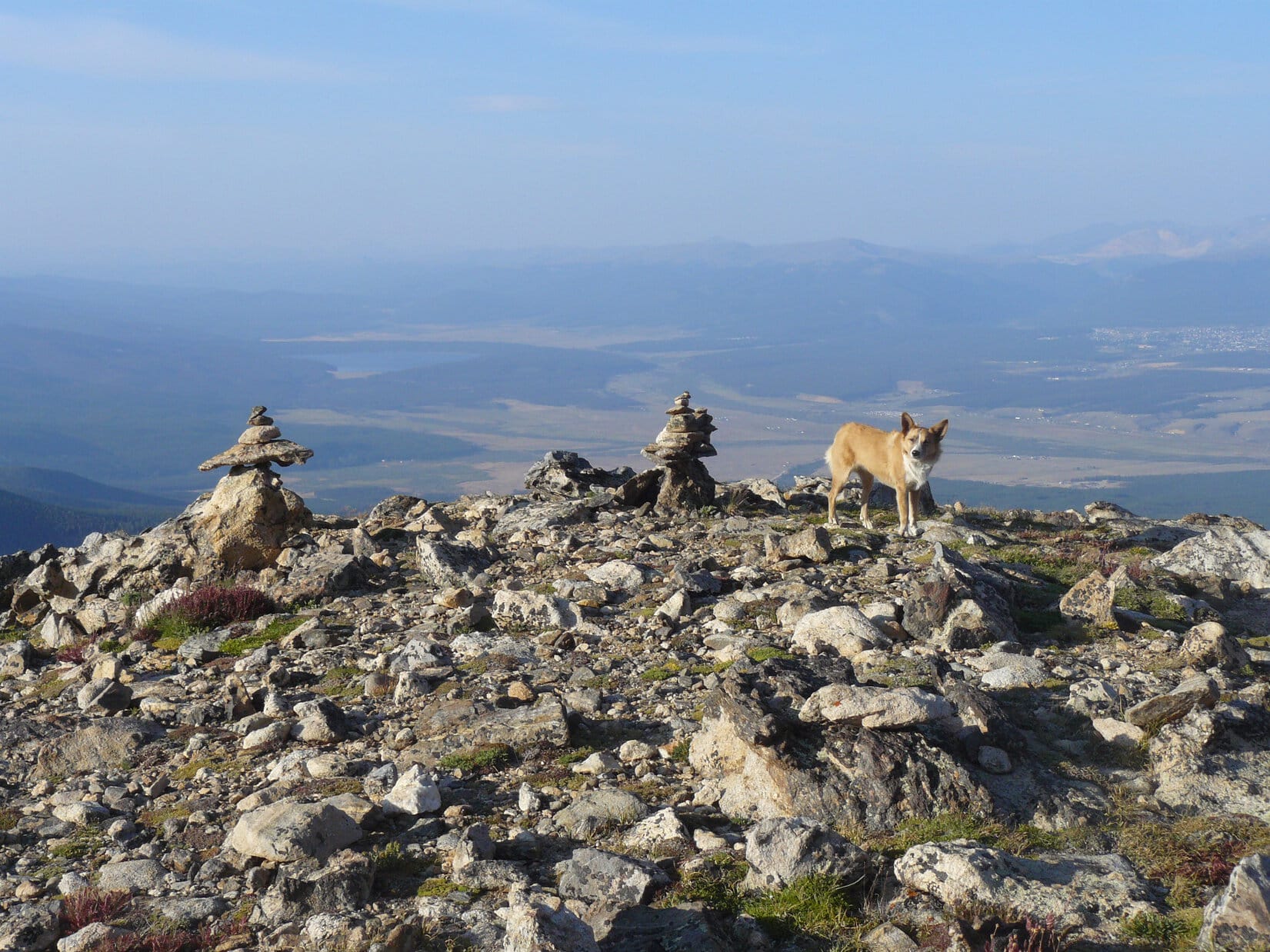
After gaining nearly 4,500 feet of elevation, Lupe was there – the summit of the highest mountain in Colorado, the state most famous for its high peaks.  Lupe stood surveying the world from the top of Mount Elbert.

Photo looks SSW. SPHP believes the high mountain near the center of this photo is 14,336 foot La Plata Peak.
Lupe on the summit of Mount Elbert.  SPHP believes the high mountain near the center of this photo is La Plata Peak (14,336 ft.).  Photo looks SSW.
Lupe reaches the summit of Mount Elbert. A hiker holds up a rather nice Mount Elbert sign designed like a Colorado state license plate to commemorate the occasion. The sign had the elevation and 8 and 15 on it for August, 2014. SPHP has no idea who produced and brought that sign up. Whoever did it was kind enough to leave it there for everyone's use.
A hiker holds up a rather nice Mount Elbert sign designed like a Colorado state license plate to commemorate the occasion. The sign had the elevation and numbers 8 and 15 on it for August, 2015. SPHP has no idea who produced and brought that sign up. Whoever did was kind enough to leave the sign there for everyone’s use.  No doubt it eventually made a nice souvenir for someone.
Mount Elbert - South Peak (14,134 ft.) is shown here on the left. It is an unranked peak connected to Mount Elbert by a ridge. The Black Cloud Trail No. 1480, an alternate route up Mount Elbert from the S, crosses Mount Elbert - South Peak on its way to Mount Elbert. La Plata Peak (R) is also in this photo.
Mount Elbert – South Peak (14,134 ft.) is shown here on the left. It is an unranked peak connected to Mount Elbert by a ridge. The Black Cloud Trail No. 1480, an alternate route up Mount Elbert from the S, crosses Mount Elbert – South Peak on its way to Mount Elbert. La Plata Peak (R), 6 miles away to the SSW, is also in this photo.
Mt. Cosgriff (13,588 ft.) (L) is another unranked peak. It is connected to Mount Elbert - South Peak (R) by a continuation of the same ridge from Mount Elbert. Photo looks S.
Mt. Cosgriff (13,588 ft.) (L) is another unranked peak. It is connected to Mount Elbert – South Peak (R) by a continuation of the same ridge from Mount Elbert. Photo looks S.
Mount Massive dominates the view to the NNW.
Mount Massive (14,421 ft.) dominates the view to the NNW.
Looking W at the upper South Fork of Halfmoon Creek basin. SPHP believes the peaks in the foreground are Casco Peak (13,908 ft.) (L of Center), Frasco Peak (13,876 ft.) (R of Center), and French Mountain (13,940 ft.) (Far R.).

Since the weather turned out to be perfect, there was a huge advantage to Lupe’s late start up Mount Elbert.  By the time she reached the summit, there were fewer than a dozen people there.  Most of those soon left.  In the end, there was only one other group on Mount Elbert.  There were two brothers and an uncle.  They were waiting for a brother-in-law, who was still struggling up the mountain on the South Mount Elbert Trail No. 1481 (which actually approaches Mount Elbert from the E).

The brother-in-law was thinking about giving up, but the rest of the family was in contact via smart phones.  They urged him onward.  He came into view below, and was eventually greeted by the family as he approached the summit.

Two brothers and an uncle greet a brother-in-law as he reaches the final ridge just short of the summit.
Two brothers and an uncle greet a brother-in-law as he reaches the NE end of the summit area.

When all four men reached the summit, Lupe joined them for a photo op.  This was the brother-in-law’s first trip up Mount Elbert, but the rest of the family had made multiple trips up the mountain.  The brother in the blue jacket and jaunty blue hat had been here six times.

Lupe with new friends on Mount Elbert. Photo looks NNW towards Mount Massive.
From Left to Right: Carlos Holguin, Jose Holguin, Edgar Flores, Luis Holguin. Edgar, of course, is the brother-in-law savoring his first ascent of Mount Elbert. Luis is the Carlos and Jose's uncle. Lupe is the Carolina Dog, but you knew that already.
From Left to Right: Carlos Holguin, Jose Holguin, Edgar Flores, Luis Holguin. Edgar, of course, is the brother-in-law savoring his first ascent of Mount Elbert. Luis is Carlos and Jose’s uncle. Lupe is the Carolina Dog, but you knew that already.

Lupe and SPHP remained up on Mount Elbert for a while longer after Edgar’s arrival.  No one else came up the mountain.  It looked like Edgar was going to be the last man up this day.  SPHP was curious about a high mountain off to the SE far beyond the Twin Lakes.  No one knew its name.

No one knew the name of the high mountain to the SE far beyond Twin Lakes.

By climbing Mount Elbert, both Lupe and SPHP set personal records for the highest mountain ever climbed.  Unless Lupe and SPHP make it out to Mount Whitney in California some day, it’s likely Mount Elbert is the highest mountain Lupe and SPHP will ever climb.

Prior to Lupe’s great Summer of 2015 Dingo Vacation, Lupe’s personal best was Lonesome Mountain (11,399 ft.) on 8-3-14 in Montana, which she climbed during her 2014 Dingo Vacation.  She had already set new records three more times during her 2015 Dingo Vacation: Medicine Bow Peak (12,013 ft.) on 8-10-15) in Wyoming, Mount Zirkel (12,180 ft.) on 8-17-15 in Colorado, and Flat Top Mountain (12,354 ft.) on 8-21-15 in Colorado.

SPHP hadn’t set a new record for highest mountain climbed in years.  Until this day with Lupe on Mount Elbert, Cloud Peak (13,167 ft.) in Wyoming, a peak SPHP has climbed twice, was the highest mountain SPHP ever stood on.

So seeing the world from up on Mount Elbert was kind of a big deal.  Before Lupe headed down, SPHP took a few extra photos of the view from the top of Colorado.

Mount Elbert - South Peak and the ridge leading to it from Mount Elbert.
Mount Elbert – South Peak and the ridge leading to it from Mount Elbert.
Twin Lakes from Mount Elbert. Photo looks SE.
Mount Massive from Mount Elbert. Photo looks NNW.
The view NW of Mt. Elbert.
Lupe on Mt. Elbert. View looking NE along the summit.
Looking NE along the summit.

And then it was time to start down.  It turned out that Edgar Flores was not going to be the last one to reach the summit of Mount Elbert this beautiful day.  Lupe met several small groups of people still heading up on her way down.  Maybe they were going to enjoy sunset on Mount Elbert.  They certainly could have.  The weather was ideal.  It hadn’t even been breezy on top.

The big crowds that had been present on the trail earlier in the day were gone.  Nearly the entire trek down Mount Elbert, Lupe and SPHP were alone.

Lupe sniffs around still near the summit. The junction of Trails No. 1184 (straight ahead) and No. 1481 (heads to the right) is shown here. Lupe will go back down No. 1184, the same way she came up. No. 1184 is the N or NE route up Mount Elbert. No. 1481 is known as the South Mount Elbert Trail, even though it actually approaches the mountain from the E.
Lupe sniffs around still near the summit. The junction of Trails No. 1184 (straight ahead) and No. 1481 (heads to the right) is shown here. Lupe will go back down No. 1184, the same way she came up. No. 1184 is the N or NE route up Mount Elbert. No. 1481 is known as the South Mount Elbert Trail, even though it actually approaches the mountain from the E.
Even though the climb up Mount Elbert doesn't feature any dangerous parts, if you wanted to, you could still manage to fall off the mountain. This is a look down a steep slope to the N while still not far from the summit.
Even though the climb up Mount Elbert doesn’t feature any dangerous parts, if you wanted to, you could still manage to fall off the mountain. This look down a steep slope to the N was taken while Lupe was still close to the summit.
Mount Massive from Mount Elbert.

Mt. Massive from Mt. Elbert, CO 8-23-15It was getting pretty dark by the time Lupe reached the G6 again at 8:19 PM (50°F).  She wasn’t going to climb any mountains higher than Mount Elbert on the rest of her Summer of 2015 Dingo Vacation, or maybe ever.  That doesn’t mean Lupe’s adventures are over though!  She encourages you to subscribe to The (Mostly) True Adventures of Lupe for news of more Dingo Adventures coming soon!

Lupe on her way down Mount Elbert, 8-23-15. Turquoise Lake is seen far below at left center. Leadville, CO is near the right edge.
Lupe on her way down Mount Elbert, 8-23-15. Turquoise Lake is seen far below at left center. Leadville, CO is near the right edge.  Lupe, the American Dingo will be seen on more lofty peaks in the American West very soon!

Links:

Next Adventure                      Prior Adventure

Want more Lupe adventures?  Choose from Lupe’s 2015 Wyoming, Colorado & Utah Adventure IndexDingo Vacations Adventure Index or Master Adventure Index.  Or subscribe free to new Lupe adventures.

Thunder Butte, Douglas County High Point, Colorado (11-6-15)

Heading S on Hwy 67, SPHP saw a sign that said Teller County.  Lupe was too far S!  SPHP must have missed the turn for Westcreek.  SPHP turned the G6 around, and headed back N looking for it.  Between mile markers 91 and 92, SPHP found two turns to Westbrook.  Both had green street signs, but there was no other evidence of a community along the highway.

Abbey Road was the first turn, and led a short distance down a hill to Westcreek Road (County Road No. 73), which left Hwy 67 about 0.5 mile farther N.  A left turn on Westcreek Road took Lupe past a few buildings, which comprised what there was of the tiny community of Westcreek.  Less than a mile after getting on Westcreek Road, there was a junction with County Road No. 68 near a little lake and the Mountain Communities Volunteer Fire Department.

County Road No. 68 was what SPHP had been looking for.  Lupe was on her way to climb Thunder Butte (9,836 ft.) , the high point of Douglas County, Colorado.  In a couple of miles, No. 68 would lead Lupe past Sheep Nose (8,894 ft.) to 9-J Road.  About 1.5 miles in on 9-J Road, there was supposed to be a place to park at a sharp bend where the road turns NW.  From there, Thunder Butte would be just a couple of miles to the NNE.

Lupe nears Sheep Nose just off Douglas County Road No. 68. Photo looks W.
Sheep Nose in Douglas County, Colorado. Photo looks W.

At 10:24 AM, SPHP parked the G6 at the bend in 9-J Road.  There wasn’t any trailhead or real parking lot, but there were at least a couple of places to pull off the road.  It was only 33°F, with a light NW breeze.  There were a few small snowflakes in the air.  Lupe would get lightly snowed on a few times during the day, but the snow squalls stayed mostly off to the N.

Thunder Butte was in clear view to the NNE.  Lupe was going to have a great time climbing it!  There was no trail up Thunder Butte, but it looked like a pretty easy trek.

Thunder Butte from near the G6. Photo looks NNE.
Lupe starts her trek to Thunder Butte. Sheep Nose is behind her to the SE.
Lupe starts her trek to Thunder Butte. Sheep Nose is behind her to the SSE.

The first part of Lupe’s journey to Thunder Butte was very easy.  She just had to follow a nearly level ridge heading NE.  When she got to the edge of Shrewsbury Gulch, she turned N staying on the ridge.  It was easiest to just stay to the W of Shrewsbury Gulch until Lupe could get around the N end of it without losing elevation.

Lupe reaches the W edge of Shrewsbury Gulch. From here she headed N staying on the ridge. Thunder Butte, her peakbagging goal for the day is visible ahead the whole way. Photo looks NNE.

Partway N along the W edge of Shrewsbury Gulch, Lupe came to Pedestal Point – a rock carved by nature over millions of years for the sole purpose of serving as a pedestal for the display of an adventurous Carolina Dog with Thunder Butte in the background.  Since Lupe was the only Carolina Dog available this day, she hopped right up on Pedestal Point rock.

Lupe poses on Pedestal Point rock. SPHP nicknamed the large rock outcropping seen above Lupe on Thunder Butte the "Snout". This photo shows the long low forested ridge at the N end of Shrewsbury Gulch that led Lupe up to the area below the Snout.
Lupe poses on Pedestal Point rock. SPHP nicknamed the large gumdrop-shaped rock outcropping seen above Lupe on Thunder Butte the “Snout”. This photo shows the long, low forested ridge at the N end of Shrewsbury Gulch that led Lupe up to the area below the Snout.
Getting close to the forested ridge at the N end of Shrewsbury Gulch. Lupe did not climb up to the lowest point of the saddle between the two halves of Thunder Butte. Instead, she climbed up below the Snout to the high point seen just to its right.

The ground along the W edge of Shrewsbury Gulch undulated up and down a little bit, but with little net elevation change.  Towards the N end of Shrewsbury Gulch, Lupe started turning slowly E towards Thunder Butte.  In some places she found a faint trail, but it quickly disappeared again each time.  Lupe worked her way through the forest over to the N side of the ridge.  The forest was full of interesting rock formations along the way.

Lupe among the boulders on the forested ridge.

Over on the N side of the low forested ridge, there was a little meadow with views to the NW.  Here Lupe turned to the E and headed directly up toward the Snout.  On the way, she emerged from the living forest and climbed up through young aspens growing in a previously burned area.

This seemed to be the easiest way up.  There was some deadfall timber, but it wasn’t too bad.  There were quite a few dead trees still standing, however.  At some point in the future when more of them fall over, the easiest route up will likely be through the living forest.

Lupe starts the climb up to the E towards the Snout. Here she is a few hundred feet N of the living forest (not pictured) on the low ridge. Photo looks E.
Approaching the Snout (R)from the W. The summit of Thunder Butte is seen on the L.
Approaching the Snout (R) from the W. The summit of Thunder Butte is seen on the L.
A look over to the lower S peak of Thunder Butte as Lupe climbed up toward the Snout. Photo looks S.

When Lupe got pretty close to the base of the Snout, she stayed to the S of it.  She was now above the living forest in an area that had been pretty thoroughly burned back in 2003.  Although that meant the immediate surroundings weren’t too pretty, it also meant there were some terrific views off in the distance.

The terrain near the Snout was fairly steep, but not dangerously so.  Lupe sniffed around, while SPHP trudged slowly up the mountain.  Lupe and SPHP arrived at a rocky outcropping to the SSE of the Snout.  From here, Lupe could get a clear view of the saddle area between the two summits of Thunder Butte.  The lower summit was to the S.  The true summit was to the N.

Lupe reaches the rocks at the high point SSE of the Snout. This photo looks S toward the lower half of Thunder Butte.
Looking W now. The low forested ridge is now way down there on the L. Lupe is almost as high as the Snout, seen on the R.
Looking W. The low forested ridge is now way down there on the L. Lupe is almost as high as the Snout, seen on the R.
Looking S toward the lowest part of the saddle over to the lower S summit of Thunder Butte.
Looking W from the rocks at the high point SSE of the Snout.
Looking S again.
Looking S again.
The beautiful remaining climb to the N up to the true summit of Thunder Butte.

Lupe and SPHP did a bit of exploring around the rocky high point SSE of the Snout.  SPHP wanted to see if there was an easy way up here from the lowest part of the saddle between the two halves of Thunder Butte.  It turned out there was a break in the rocks with a wide grassy pass between them.  The pass led down to the saddle.  It looked kind of steep, but was certainly a feasible route up or down.

In this pass, Lupe and SPHP also discovered the Most Interesting Rock of Thunder Butte.  The Most Interesting Rock stuck out over part of the pass from the W.  SPHP liked the unusual shape of the rock and its overhanging positioning.  Lupe agreed to strike a dramatic American Dingo pose on the Most Interesting Rock.

An American Dingo poses dramatically upon the Most Interesting Rock on Thunder Butte.
Lupe on the Most Interesting Rock. Photo looks SE.

From the Most Interesting Rock, Lupe and SPHP started the climb to the N up to the true summit of Thunder Butte.  Shortly before getting there, Lupe reached a ridge that led the last little way to the NW up to top.  Soon Lupe was sitting on the highest rocks on Thunder Butte next to a registry.  SPHP entered Lupe’s name on the registry for her, and signed in as well.

After registering, it was time for a break.  Lupe chowed down on some Taste of the Wild, while SPHP consumed an apple.  Then there was plenty of time for admiring views, and taking some pictures.  There were great views to the SE, S, W, and NW.  A small area of living forest mostly hid the views to the N, NE and E.

Lupe gains the ridge that leads the last little bit of the way up to the NW to the true summit of Thunder Butte.
Lupe reaches the register on Thunder Butte, successfully completing her 2nd peakbagging goal of her November, 2015 vacation to Colorado.
Lupe reaches the registry on Thunder Butte, successfully completing her 2nd peakbagging goal of her November, 2015 vacation to Colorado.  Photo looks S.

Thunder Butte, CO 11-6-15

Lupe gets speckled with a bit of snow as she enjoys some Taste of the Wild on Thunder Butte.
Looking S from the top of Thunder Butte. The lower S summit is seen in the foreground. SPHP believes the high mountain in the clouds in the distance is Pikes Peak.
Looking S from the top of Thunder Butte. The lower S summit is seen in the foreground. SPHP believes the high mountain in the clouds in the distance is Pikes Peak (14,110 ft.).

Pikes Peak from Thunder Butte, CO 11-6-15

Lupe on Thunder Butte, CO 11-6-15

Looking NW. Portions of Cheesman Lake are visible.

Looking NW from Thunder Butte, CO 11-6-15

Looking S toward Pikes Peak. Sheep Nose is visible on the R.

Lupe on Thunder Butte, CO 11-6-15

Looking W from Thunder Butte, CO 11-6-15Lupe and SPHP had a fun time up on the summit of Thunder Butte.  The views were magnificent, and the solitude complete.  Sadly, eventually, it was time to go.  On the way down, SPHP tried to get some pictures of the views to the NE which weren’t available from the summit.

Looking NE from Thunder Butte. SPHP believes Turtle Mountain is shown here.
Looking NE from Thunder Butte. SPHP believes Turtle Mountain (8,882 ft.) is shown here.
Going SE down the ridge from the summit.
Looking S at the lower S peak of Thunder Butte. Sheep Nose is on the R. At lower R is the top of the Snout. Pikes Peak in the distance.

The Snout on Thunder Butte, CO from above 11-6-15

Looking E.
Looking E.
Looking NE at Turtle Mountain.

Lupe and SPHP retraced their route up back down Thunder Butte.  Once down to the low forested ridge, Lupe did some sniffing around in the forest among the interesting rock formations.  The sun was starting to get low in the W.  However, there was still plenty of time to get back to the G6.  Lupe and SPHP had some fun among the rocks.

Lupe went SW from this rock formation along the low, forested ridge N of Shrewsbury Gulch. Photo looks SW.
Looking NE at the turning point rock.
Looking back NE at the rock after Lupe passed it.
Looking S at Sheep Nose from the low, forested ridge W of Thunder Butte.
Lupe's route back to the G6 went along the W side of Shrewsbury Gulch almost directly toward Sheep Nose.
Lupe’s route back to the G6 went along the W side of Shrewsbury Gulch almost directly toward Sheep Nose.
The S sub-peak of Thunder Butte. Photo looks E.
Sheep Nose from the N.
Lupe returns to Pedestal Point rock.
You guessed it! Sheep Nose!

Lupe found her way to the G6, but SPHP called her away again.  It was so nice out, SPHP wanted to go a little closer to Sheep Nose for a better look.  Earlier in the day, SPHP had ruled out trying to climb Sheep Nose, which looked like it might require some technical climbing skills and equipment.  Sheep Nose was still an interesting looking peak.  Maybe it looked less troublesome from closer up.

Lupe near Sheep Nose. Not a huge peak, but still fairly rugged and quite interesting looking. Photo looks SSE.
Lupe near Sheep Nose. Not a huge peak, but still fairly rugged and quite interesting looking. Photo looks SSE.  Interested in living near Sheep Nose?  Go back to the first photo of Sheep Nose near the start of this post.  The roof of a mobile home can be seen.  The home was for sale by owner when Lupe went by it this day.
Looking toward Pikes Peak from the W side of Sheep Nose.

Lupe and SPHP returned to the G6 at 4:00 PM exactly.  It was 35°F, and a beautiful calm late afternoon.  Lupe’s trek to Thunder Butte had been a fun day, and a great success!

There had been easy parts on nearly level ground near Shrewsbury Gulch, and harder parts climbing steeply up the mountain.  Lupe had seen and/or explored cool rock formations like Pedestal Point rock, the Snout, the Most Interesting Rock, and the boulders along the low forested ridge.  There had been great views from the top of the mountain, and at many points on the way up.

Lupe did have one complaint, though.  She never found a single squirrel in the forest the whole day long.

Thunder Butte, CO, the Douglas County high point from N of Sheep Nose.
Thunder Butte, the Douglas County, Colorado high point from N of Sheep Nose.

Links:

Next Adventure                       Prior Adventure

Want more Lupe adventures?  Choose from Lupe’s 2015 Arvada, CO Adventure IndexDingo Vacations Adventure Index or Master Adventure Index.  Or subscribe free to new Lupe adventures.