Pepper Peak, Chugach State Park, Alaska (8-31-16)

Day 33 of Lupe’s Summer of 2016 Dingo Vacation to the Canadian Rockies, Yukon & Alaska

Yowser!  Over 4,500 feet of elevation gain!  Most definitely a long day ahead.  Yet it would be a glorious one, if Lupe and SPHP could make it to the top of Pepper Peak.  Soup, Swiss Miss and sardines for breakfast.  SPHP was sick of sardines, but Lupe devoured the rest of the tin with gusto.  Thank heavens!

SPHP paid the $5.00 daily trailhead parking fee, then Lupe went down for a look at gorgeous Eklunta Lake.  Totally clear skies and nearly calm.  Conditions were going to be perfect!  After a few minutes along the lakeshore, Lupe and SPHP went looking for the trail to Twin Peaks.  (9:19 AM, 39°F)

Lupe’s long last day of August 2016 started on the shore of beautiful Eklunta Lake. Photo looks SE.

On the way to the trail, Lupe got a glimpse of what was in store for her – the long, long SW ridge of Pepper Peak (5,381 ft.).  The view was a bit daunting.  It didn’t look scary, or like something Lupe couldn’t do, just exhaustingly long.  As they say, though, every journey starts with that first step.  Lupe’s paws were already trotting right along.  She would get up Pepper Peak, if SPHP could.

The sheer size of Pepper Peak from down near lake level was a bit daunting. However, it didn’t look like anything technical or too scary. Lupe could do that! Photo looks NE.

Lupe crossed a bridge over Thachkatnu Creek.  The Twin Peaks trail headed off to the L (NNW).  Lupe’s long climb began.

Such a beautiful day!  The Twin Peaks trail started in a forest.  There wasn’t much to be seen except the trees.  The trail zigged NE.  Right away, Lupe gained 300 or 400 feet of elevation on a relentless, fairly steep climb.  The trail then zagged NW for a longer stretch on the way to the Thachkatnu Creek valley between Twin Peaks and Pepper Peak.

The trail wasn’t as steep along in here.  Autumn was already on its way to Alaska.  Leaves were beginning to turn yellow.  Lupe sniffed and explored along the newly carpeted Yellow Leaf trail.

Follow, follow, follow, follow, follow the Yellow Leaf Trail! Toto on the way to the Emerald … no wait, make that Lupe on a relatively flat section of the Twin Peaks trail on her way to the Thachkatnu Creek valley between Twin Peaks and Pepper Peak. Photo looks NW.

As the Twin Peaks trail reached the Thachkatnu Creek valley, it turned NE again, staying high up on the Pepper Peak side.  Near the gradual turn, the trail had become steeper, gaining elevation even faster than before.  Lupe gained another 300 or 400 feet before the slope slackened as the trail zigged back to the SE.

Lupe had gained enough elevation by now so that she was getting close to tree line.  The forest was starting to thin out a bit.  Along another steep climb to the NE, Lupe reached an opening with a gorgeous view of Eklunta Lake.

Lupe reaches the first clear view of Eklunta Lake from the Twin Peaks trail. Photo looks SE.

Two benches are positioned along the Twin Peaks trail.  Lupe was almost to the first one.  Another steep little climb and she was there.

SPHP had been looking for the benches for a while.  Lupe had already come so far, SPHP thought it was possible she had somehow missed the first bench, but this was actually it.  As SPHP learned a little later on, only the first bench has a view of Eklunta Lake.

Lupe reaches the first of two benches along the Twin Peaks trail. Only the first bench has a view of Eklunta Lake. Photo looks SE.

From the first bench, the trail turned back to the NW again leaving Eklunta Lake behind.  Lupe was still mostly in forest, but tall bushes were becoming more prominent.  From here on, the trail kept climbing steadily.  Lupe came to no more relatively level sections.  It was all sort of steep.

Soon Lupe was back over toward the Thachkatnu Creek valley again.  Once more, the trail turned NE going up the valley, remaining high up on the Pepper Peak side.  The forest gave way to the tall bushes as Lupe went up.  Lupe could see Twin Peaks towering over the opposite side of the valley.

Twin Peaks from the Twin Peaks trail before reaching the 2nd bench. Photo looks NNW.

Lupe must have been almost a mile from the first bench, when she reached the second one.  This bench was located on the Thachkatnu Creek side of Pepper Peak’s SW ridge.  Twin Peaks were in view, but not Eklunta Lake.  There were still lots of tall bushes near the second bench, but Lupe wasn’t far from reaching bush line where the views would really open up.

At the second bench, Lupe faced a choice.  She could continue following a trail, presumably part of the Twin Peaks trail, up the Thachkatnu Creek valley toward the saddle between the Twin Peaks and Pepper Peak.  The other choice was to take a side trail going SE up to the SW ridgeline coming down from Pepper Peak.

According to information SPHP had found online, Lupe could eventually reach the top of Pepper Peak either way.  However, the trail going up the Thachkatnu Creek valley would have limited views for a long way.  On Pepper Peak’s SW ridge, Lupe would be able to see Eklunta Lake the entire time, plus lots of magnificent mountains beyond.

With no more to go on than that, the choice was easy.  Lupe left the second bench following the trail toward the SW ridge.

Lupe takes a break while SPHP checks the map. She is already a little past the second bench back at the Twin Peaks trail, on her way over to the SW ridgeline coming down from Pepper Peak. By now, she was above the forest and tall bushes, but still faced a tremendous climb to the top of Pepper Peak. Photo looks NE.

The ridgeline was farther from the second bench than SPHP expected, but it didn’t take Lupe too long to get there.  Beautiful Eklunta Lake was in sight again.

Lupe reaches Pepper Peak’s SW ridgeline after leaving the Twin Peaks trail and the second bench behind. Even though a very long way remained to the top of Pepper Peak, she had definitely made some progress. The view of Eklunta Lake was getting better and better. Photo looks SE.

Lupe had already come a long way, but the real climb, the long one up Pepper Peak’s SW ridge was just about to begin.  Lupe was no longer on any formal, maintained trail, but there was still a path leading higher.  Even without the path, the route was plain to see.  Just keep heading up the ridge.

Lupe climbed and climbed.  The views kept improving with every step higher.

Going up Pepper Peak’s SW ridge. Photo looks NE.
West Twin Peak (5,472 ft.) (L) and East Twin Peak (5,840 ft.) (R) from Pepper Peak’s SW ridge.  Sorry ’bout making you stare into the sun, Looper! Photo looks NW.

For a long way, Pepper Peak’s SW ridge was broad and rounded.  Other than the steepness, there were no other issues at all to deal with.  Up and up was all there was to it, as fast as heart, lungs, legs and desire allowed.  SPHP was getting close to a high point near the end of this relatively easy part of the climb, when suddenly Lupe let out a tremendous WOOF!

SPHP looked around.  Nothing.  What on earth was she woofing at here?  Lupe WOOFED again.  Oh, there!  SPHP looked up, straight up.  Two parasailors were floating high above!

Lupe spotted these two parasailors high above Pepper Peak’s SW ridge. Photo looks, yes, UP!

Wow!  That looked both scary and amazingly fun.  Time for a parasailor break!  Lupe and SPHP went just a little higher to the top of the nearby high point, then stopped to watch the parasailors for a while.

The parasailors were moving quite fast.  They lost elevation relatively quickly, but seemed to have no problem finding thermals to take them soaring again.  It was incredible how far and fast they flew.  The one with the pink chute soon flew miles away to the SE far beyond Shaker Peak, and ultimately completely out of sight.

The parasailor with the green, white and blue chute hung around for a while.  He made a couple of passes not terribly far above Lupe, which excited her tremendously.  She had never seen such a huge bird in all her life!  Why it must be a Roc, or a Pterodactyl!

The parasailer with the pink chute soon flew miles away out of sight far beyond Shaker Peak, but this one stuck around to buzz Lupe a couple of times. Was she ever excited! She had never seen a Pterodactyl so close up before! It’s wingspan was HUGE! However, even a Pterodactyl didn’t have the guts to come all the way down to the ground to tangle with an American Dingo!
Simply WOW! What else is there to say?

The second parasailor drifted away out of sight.  Wow!  SPHP wondered where they had started from, and how they would ever get back.  Who knew?

Time to press on again.  The way forward was becoming steeper and rockier.  The toughest part of the climb was about to begin.

Lupe at newly designated Parasailor Point. The toughest part of the climb up Pepper Peak was about to begin. Photo looks NE.
Salt Peak (5,455 ft.) (L) and Shaker Peak (5,089 ft.) (R) from Parasailor Point. Photo looks E.

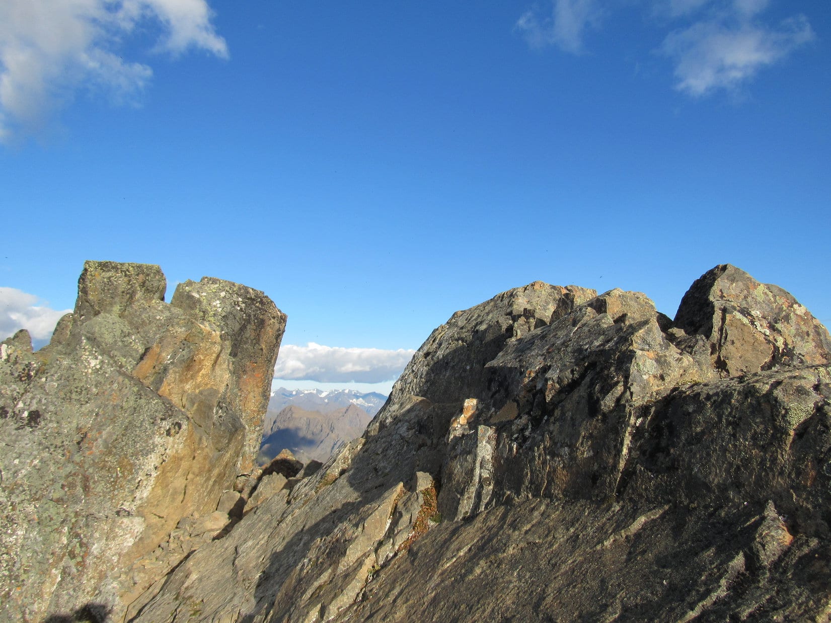
The ridge became rockier and rockier as Lupe progressed.  There was still a trail, but it was less well-defined and harder to follow.  The slope became steeper.  Exposure increased.  Lupe encountered more and more loose rock.  She tried to stay up near the ridge line, but wound up a little below and to the SE of it.

Looking NW toward Twin Peaks just before tackling the last, big ragged rocky section of Pepper Peak’s SW ridge.
The last ragged, rocky section nearing the top of Pepper Peak. Lupe stayed a little below the ridgeline on the SE (R) side. The trail was hard to follow here. Lupe encountered quite a bit of loose rock and some exposure. Photo looks NE.

Although the ragged part of the ridge wasn’t terribly long, it took a while to navigate it.  Lupe finally got past it, though.  The ridge was now leveling out.  The going was getting a lot easier.  It couldn’t be much farther to the top of Pepper Peak!

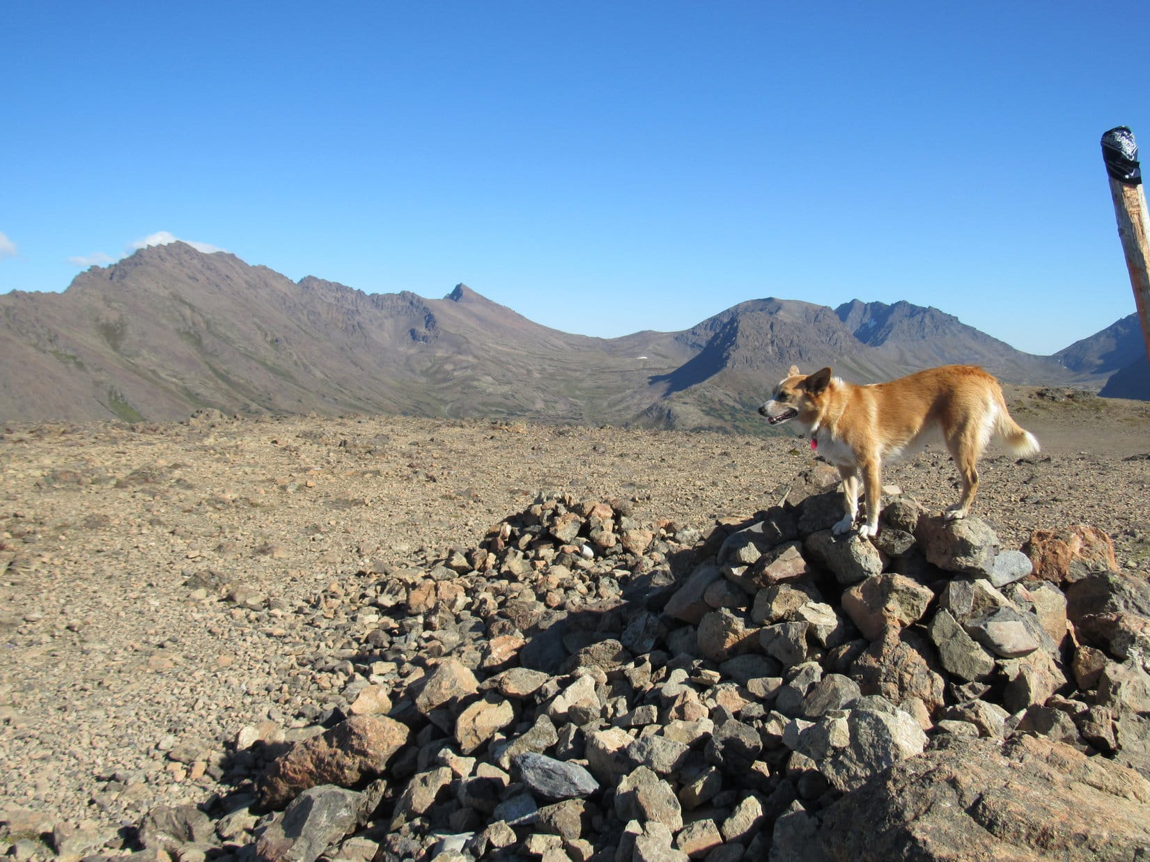
Ahead was one more big knob of rock.  Lupe and SPHP had seen it from far, far below.  SPHP believed it was the summit.  Lupe seemed to be way up in the sky.  Who knew what kind of precipice might be on the other side?

The trail was in much better condition again here.  It wound up the SE side of the knob.  Lupe headed up.  SPHP followed close behind.

Lupe on her way up the last craggy knob. Photo looks N.

Lupe reached the top of the craggy knob.  SPHP was glad to see Lupe had not arrived at a pinnacle surrounded by dangerous cliffs.  The top of the craggy knob wasn’t terribly large, but had a nice, flat area where Lupe could relax with a fantastic view of Eklunta Lake.

Lupe arrives up on top of the last craggy knob of Pepper Peak’s SW ridge. She had a nice flat area on which to relax. The view of Eklunta Lake more than 4,000 feet below was fantastic! Photo looks SE.

As Lupe had approached the craggy knob, SPHP caught a glimpse of a rounded hill some distance beyond it.  The truth became clear even before Lupe reached the top of the knob.  This last knob of rock was not the summit of Pepper Peak.  The true summit was over at the top of the rounded hill.

This wasn’t bad news.  In fact, it was good news!  The remaining distance to the true summit was an easy trek.  The trail followed an almost level final stretch of ridgeline straight toward it.  Piece of cake!  When Lupe arrived, she was going to find a nice, big, roomy summit.  She could be there in minutes!

Even before Lupe reached the top of the final crag of rock coming up the SW ridge, the last stretch of the ridgeline leading to the true summit of Pepper Peak came into view. Getting there was going to be a piece of cake! Photo looks N.

The views were so amazing, Lupe and SPHP stayed on the last craggy knob of rock for a few minutes before continuing on.

The final journey to the true summit was joyous.  Lupe was going to make it to the top of Pepper Peak!  She arrived to find a large cairn at the high point at the N end of a spacious summit.  This was it.  More than 4,500 feet above where she’d started, Lupe stood at the very top of Pepper Peak (5,381 ft.)!

Lupe reaches the true summit of Pepper Peak! Twin Peaks, and the saddle leading over to them, are in view beyond her. Photo looks NW.

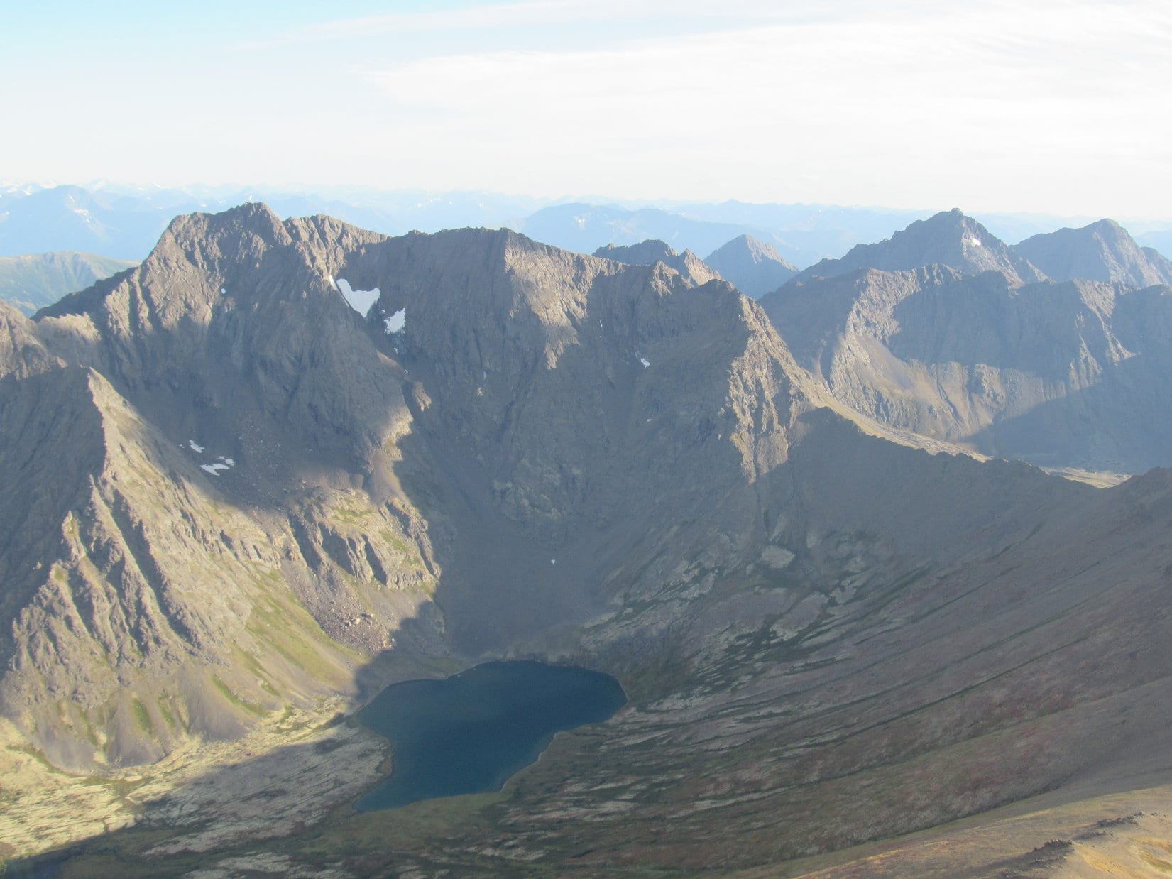
The summit of Pepper Peak was an amazing place!  Lupe had sweeping 360° panoramic views.  Nearby, she could see many peaks of similar elevation.  Long, barren ridges, many knife-edged, connected one peak to another to another.  In between the ridges were deep U-shaped valleys carved by long departed giant glaciers of the ice age.  Eklunta Lake was a beautiful highlight, with big snow and ice-covered peaks in sight miles away beyond its S end.

However, Pepper Peak had a lot more to offer than just the glories relatively close at hand.  Pepper Peak is a place for binoculars.  Despite not being the highest peak around, Lupe could see tremendous distances in most directions.  On the far horizons gleamed many white wonders of Alaska.  SPHP knew the names of a few, but most were unknown places of mystery, glimpsed for the first time from afar here on Pepper Peak.

One of the more spectacular high peaks in the distance far from Pepper Peak. Photo looks ESE using the telephoto lens.
Many of the grand peaks visible in the distance from Pepper Peak were so far away, it was next to impossible to get both Lupe and the distant mountain in focus in the same photo.

To the SW, barely visible beyond shimmering Cook Inlet, Lupe could make out Redoubt Volcano (10,197 ft.) and nearby white mountains of the Aleutian Range.  Redoubt was so far away, it hardly even showed up in a photo.  To the NW, still far off, but somewhat closer, were the colossal peaks of the Alaska Range.  Mount Foraker (17,400 ft.) and Denali (20,310 ft.) at least showed up using the camera’s telephoto lens.

Denali, the highest mountain in North America, from Pepper Peak using the telephoto lens. Photo looks NW.
Mount Foraker. Photo looks NW.
Unknown peaks of the Alaska Range visible from Pepper Peak. Photo looks NW.

To the ESE, Lupe saw a huge, long snowy ridge.  SPHP had no idea what the names of any of those mountains along the ridge were, but the sight was spectacular, and not quite so far away.  In fact, the views toward the E and S were the most amazing of any Lupe saw from Pepper Peak.  The amount of snow and ice visible, even from a distance, was incredible!

Amazing sights were to the E & S of Pepper Peak, such as this huge, long, towering ridge of white mountains. Photo looks ESE.
Looking ESE with even a little more help from the telephoto lens.
Many people only go as far on the Twin Peaks trail as the first or second bench. Nice, of course, but only by coming all the way up to the top of Pepper Peak will you see this!
The huge snowy ridge connected to an enormous snowfield to the S. Photo looks SE.
Wow! Gorgeous! Love that soft appearing pure white ridge on the R.

Of course, Eklunta Lake to the SSE and the snowy peaks beyond it were highlights of the views from Pepper Peak, too!

Eklunta Lake from the summit of Pepper Peak. The high peak on the left is Bold Peak (7,522 ft.). Photo looks SSE.
Peaks beyond Eklunta Lake through the telephoto lens. Photo looks SSE.
More peaks beyond Eklunta Lake. Still looking SSE, but a bit more toward the S.
Bold Peak (7,522 ft.), seen again here, is a couple miles E of the S end of Eklunta Lake. Photo looks SE.
S end of Eklunta Lake using the telephoto lens.

Before arriving at the summit of Pepper Peak, SPHP had given some thought to having Lupe go on to Shaker Peak (5,089 ft.), about a mile away to the SE.  However, the views were so splendid from Pepper Peak, and it had been such a long climb to get here, that the Shaker Peak idea got dropped.

Lupe was fine with the decision.  It meant she got a nice long rest on Pepper Peak, while SPHP continued to stare off into the distance in fascination.

Anyone out there know the name of this eye-catching mountain?
Looking N toward Palmer and the Matanuska River. Lazy Mountain (3,740 ft.) is seen on the R. Lupe hoped to climb Lazy Mountain tomorrow!
It was hard not to keep coming back to this view again and again. It made such an impression! Photo looks ESE.
SPHP believes the top of Shaker Peak is in view here on the lower right. Photo looks SE.
Looking ESE again.
Lupe at Pepper Peak’s summit cairn with Mount Foraker(L) and Denali(R) in the distance. Photo looks NW.
Lupe with Denali in the background. Lupe never got a clear view of Denali when she had been in Denali State Park. The titanic mountain had almost always been completely hidden in the clouds. She had a clear, if distant, view of it from Pepper Peak, though! Photo looks NW.

Looper and SPHP stayed up on Pepper Peak for more than 2 hours.  Only one other person came up to the summit during all that time, despite the perfect weather.  An Alaskan named Craig appeared from the Twin Peaks route.

SPHP raved about the views from Pepper Peak.  To Craig, though, Pepper Peak was just another pleasant summit among many in Alaska.  Craig stayed all of 10 minutes on top, then headed for the SW ridge Lupe had come up.  Another day, another amazing mountain in Alaska, ho-hum.

SPHP’s enthusiasm wasn’t diminished in the least.  Lupe seemed happy here, too!

Loopster on Pepper Peak with gorgeous Eklunta Lake as a backdrop. Photo looks SSE.
Lupe keeps an eye on the sky. You never know when another Pterodactyl might choose to come swooping down on you around here!
Did you bring any water, SPHP? I’m getting thirsty just looking at this.
Well, did you? Bold Peak on the L.
Hmmm, this is starting to look faintly familiar. Sure is beautiful, though! Loopster, we need one of these for the back yard!
This would do nicely, as well.

Lupe was just chillin’ up on Pepper Peak, while SPHP took more photos of photographed photos.  Although time was moving on, SPHP found it difficult to tear away from the tremendous views.  Mountain mania continued a little longer.

Lupe chillin’ on Pepper Peak with the Twin Peaks in view beyond her. Photo looks WNW.
Lupe wasn’t in any big hurry to leave either. She liked Pepper Peak just fine. Photo looks SW.
See that white peak poking up on the far left? SPHP wondered if Lupe hadn’t also seen it from The Ramp (5,240 ft.) a couple of days ago.
Looking S.
This photo doesn’t make as much use of the telephoto lens, but shows the relationships between some of the peaks better.
Sweet! Cranking up the telephoto lens for an even closer look than before.

After more than 2 hours on Pepper Peak, it really was time to go.  Even so, it was hard to tear away from the incomparable views.  This climb had been so worthwhile!  SPHP was very glad Lupe had made the trip.  At last, though, Lupe had to begin the trek back to the G6.

On the way down, Lupe was going to take the Twin Peaks route, even though it meant not being able to see as much along the way.  The Twin Peaks route did have one advantage.  Lupe would avoid the rocky scramble along the upper part of Pepper Peak’s SW ridge.

Exactly how to get to the Twin Peaks route wasn’t entirely clear.  One thing was for certain.  Lupe needed to get down to the saddle between Pepper Peak and Twin Peaks.  Craig had reached the summit cairn coming up from the N, which was the shortest route and probably made the most sense.

Lupe, however, started off going S back down toward the last rocky knob she’d reached on the SW ridge on the way up.  Before she quite got to it, she turned sharply back toward the N, following sheep trails below and to the W of the summit of Pepper Peak toward the saddle to Twin Peaks.

Approaching the last rocky knob of Pepper Peak’s SW ridge (seen on the L) on the way down from the summit. From here, Lupe turned sharply almost 180° back toward the right. She followed sheep trails below the summit over to the saddle between Pepper Peak and Twin Peaks. This worked just fine, though Craig’s more direct route going N from the summit was shorter and probably just as easy. Photo looks WSW.
Looking back up toward Pepper Peak from the saddle leading to Twin Peaks. Photo looks SSE.
Lupe saw a couple herds of sheep way over on the slopes of the Twin Peaks. Several dozen sheep were in sight. Photo taken using the telephoto lens.

The trail Lupe was following along the saddle seemed determined to stay up on the ridgeline.  Perhaps SPHP gave up on the trail too soon?  Lupe and SPHP left it to start heading down into the Thachkatnu Creek valley, expecting to find another trail down there before too long.  That didn’t happen.

As is often the case, Lupe had most of her fun on the Pepper Peak excursion on the way back to the G6.  She loved roaming the tundra in the Thachkatnu Creek valley!  She ran far and wide, sniffing and exploring.  At times she was just a distant speck of a Dingo.  Once she reappeared from a completely unexpected direction after being out of sight for a few minutes.

Pepper Peak from the upper part of the Thachkatnu Creek valley, still not terribly far below the saddle between Pepper Peak and the Twin Peaks. Photo looks SE.

The route back down via the saddle and Thachkatnu Creek valley had absolutely no scrambling, exposure, or areas of loose rock.  So it’s perfectly possible to reach the top of Pepper Peak completely avoiding that kind of thing.  Somewhere, there’s probably a decent trail much of the way, but it must have been closer to Twin Peaks than Lupe and SPHP went.

For a long, long way, Lupe and SPHP lost elevation without coming to a trail.  The vegetation became denser and taller as Lupe went lower.  However, she didn’t get quite all the way down to where the tall bushes and forest started in earnest.  Lupe finally found a trail when she was about at the elevation of the second (higher) bench on the Twin Peaks trail.  By then, she wasn’t that far away from it.

Lupe and SPHP lost even more elevation crossing Thachkatnu Creek, but immediately had to regain it, climbing steeply on the other side.  Not too surprisingly, Lupe arrived at the Twin Peaks trail right at the second bench.  All that remained was a long, pleasant downhill stroll on the Twin Peaks trail.

Near the first bench, Lupe saw Eklunta Lake in the evening sunlight one more time from above.

Eklunta Lake in the evening sunlight from near the first bench on the Twin Peaks trail. Photo looks SE.

And one more time, Lupe followed the Yellow Leaf trail, this time all the way to the end of her magnificent Pepper Peak adventure.  (8:38 PM, 58°F)

On the Yellow Leaf trail once more.

Links:

Next Adventure                       Prior Adventure

Chugach State Park

Chugach State Park Map

Chugach State Park Brochure

Want more Lupe adventures?  Choose from Lupe’s 2016 Canadian Rockies, Yukon & Alaska Adventure Index, Dingo Vacations Adventure Index or Master Adventure Index.  Or subscribe free to New Lupe Adventures.

Flattop Mountain, Blueberry Knoll & Thunder Bird Falls, Chugach State Park, Alaska (8-30-16)

Day 32 of Lupe’s Summer of 2016 Dingo Vacation to the Canadian Rockies, Yukon & Alaska

The replacement part didn’t look the same as the original one.  Figures.  SPHP didn’t have the tools, or the knowledge required to fix the problem.  Better not mess with it any more.  For some reason, lots of bees were flying around the O’Reilly Auto Parts store parking lot, and SPHP is allergic.  Time to get out of here!  Even though the G6’s right front headlight still wasn’t working, SPHP reassembled everything.

When SPHP had taken it all apart, hoping to simply replace the low beam headlight bulb, it turned out that wasn’t the problem.  The bulb was fine, but the socket it fit into was partially melted.  O’Reilly had the replacement part, or something that was supposed to work, for less than $10.

However, there was no telling what it would take to find someone here in Anchorage who knew where that extra wire on the replacement socket should go, and had both the time and tools needed to install it.  A simple oil change had been $60, and taken hours to line up this morning.

When Lupe got home to the Black Hills in South Dakota, SPHP was going to just order a whole new headlight assembly and be done with it.  That meant the $50 fix-it ticket would have to be paid, since there was no way an Alaskan state trooper would ever get to inspect the new headlight to confirm it worked, but that’s life.  Que sera, sera.

No more wasting Lupe’s precious time in Alaska!  The morning had already shot by.  Fortunately, there was a nice little adventure she could do this afternoon.  Lupe could climb Flattop Mountain (3,510 ft.), the most frequently climbed mountain in Alaska, with great views of Anchorage from the top!

Back to the Glenn Alps Trailhead (2:39 PM, 61°F)!  Only yesterday, Lupe had started off from here for a fabulous day spent climbing The Wedge (4,660 ft.) and The Ramp (5,240 ft.).  Glenn Alps, located on the SE side of Anchorage, was also the trailhead for Flattop.  Having spent all morning lazing around resting up in the G6, Lupe was ready and raring to go.

Lupe starts off for Flattop Mountain, seen beyond her. The trail to the top of Flattop from the Glenn Alps trailhead is about 1.6 miles long and gains roughly 1,300 feet of elevation. Photo looks SE.

Climbing Flattop wasn’t going to be the solitary, wilderness type experience Lupe had enjoyed most of yesterday climbing The Wedge and The Ramp.  On this beautiful, warm summer afternoon, the trail to Flattop Mountain was packed with hikers (and dogs) of all descriptions.

The trail started off entering a forest, but Lupe was soon beyond that.  She followed the trail gaining elevation gradually as it led her around the SW side of Blueberry Knoll (2,625 ft.).  Flattop Mountain was directly ahead.

Flattop Mountain from the SW slope of Blueberry Knoll. Reportedly, there are 2 ways up Flattop. Everyone seemed to be taking the steepest, most direct route, which climbs up the ridge on the L protruding toward the camera. Lupe took the steep route, too. Lupe never saw the easier route, which presumably goes up somewhere more to the W (R). Photo looks SE.

Once around Blueberry Knoll, the trail swept around the SW (R) side of another, steeper hill, part of the ridge extending NNW from Flattop Mountain.  The trail steepened as it turned E (L) again back toward a saddle between this higher hill and the rest of Flattop Mountain.  Lupe encountered a long series of wood framed steps filled with dirt and gravel on the way to the saddle.

Reportedly, there are two popular routes up Flattop Mountain.  The steepest, most direct, route switchbacks right up the slope from the saddle to the top of Flattop.  An easier route presumably goes somewhere more to the W (R).  Lupe and SPHP never saw the trail for the easier route, although it likely separates from the steeper route somewhere close to, or a little above the saddle.

On this warm, dry, summer day, everyone seemed to be taking the steepest route right on up.  Lupe took the steep route, too.

Lupe on the switchbacks of the steep route. After a bit of a light scramble, the trail eventually reaches the top a little to the R of Center.

The switchbacks brought Lupe quite close to the top of the mountain, but the last 50 to 75 feet of elevation gain was more difficult.  Here, the going was steeper, with large rocks and big steps up.  A little light scrambling was required to reach the top.  Nothing too tricky, but a bit of caution needed to be exercised along in here.

Lupe reached the top of Flattop Mountain a short distance W of an American flag flying at the N end of the summit area.  Everyone was busy getting their pictures taken next to the flag.  While Lupe was waiting for the crowd to clear out for her turn, she went to investigate some big cairns nearby.

Climbing Flattop Mountain, Lupe had gained about 1,300 feet of elevation, only a fraction of what she’d gained climbing The Wedge (4,660 ft.) and The Ramp (5,240 ft.) yesterday.  However, she had a decent view of both mountains from Flattop.

Lupe waits for her turn for a picture at the American flag on Flattop Mountain from a big cairn nearby. Beyond her are O’Malley Peak (5,150 ft.) (L), The Ramp (pointy peak L of Center), and The Wedge (on the R straight up from Lupe’s head). Lupe had climbed both The Ramp and The Wedge yesterday. Photo looks E.

Soon it was Lupe’s turn at the American flag.

An American Dingo stands proudly next to the American flag on Flattop Mountain. Photo looks N.

Of course, with a name like Flattop Mountain, the summit area was very large, and rather, umm, flat.  The top of the mountain was stony, and completely open with very little vegetation.

Still, there were a few things to explore.  People had constructed big cairns, and even a large, circular stone fort.  The true summit was at a collection of rocks off toward the SW.  The mountain offered 360° views.  While most people congregated near the American flag, Lupe went off to see what there was to see.

Powerline Pass is seen on the L. Just to the R of it is South Powerline Peak (4,500 ft.). The greenish near hill should be Peak 2 (3,609 ft.), with Peak 3 (4,068 ft.) seen beyond it on the R. The highest peak near Center is either Ptarmigan Peak (4,910 ft.) or possibly Flaketop Peak (4,488 ft.). Photo looks SE.
A closer look through the telephoto lens. Peak 2 at lower L, Peak 3 on the R, with either Flaketop or Ptarmigan Peak in the distance near the Center. Photo looks SE.
Lupe near the circular stone fort. Photo looks S toward McHugh Peak (4,308 ft.).
Loop at the true summit of Flattop Mountain. Photo looks NW toward Anchorage and Cook Inlet.
Downtown Anchorage seen through the telephoto lens. Nearly all of Anchorage is in view from Flattop Mountain. The view of the city lights at night must be grand!
The Turnagain Arm from Flattop Mountain. S Anchorage is seen below. Photo looks SW.
Although Lupe was here on a cloudless day, the air was still somewhat hazy, perhaps due to humidity. This photo looks NW using the telephoto lens to see past Anchorage and Fire Island toward the giant snowy peaks beyond Cook Inlet. Sunsets must be awesome from Flattop Mountain with the city of Anchorage, ocean, and impressive mountains all in view!
Looper on top of Flattop with Peak 2, Peak 3 and Ptarmigan or Flaketop beyond. Photo looks SE.
The Ramp(L) from Flattop. Photo looks E.

Too bad Lupe and SPHP didn’t do things in reverse order this day!  The views of the Turnagain Arm, Cook Inlet, and Knik Arm of the ocean, plus all the surrounding mountains at sunset would have been a sight to behold!  Shortly after that, Lupe would have had a sweeping view of all the lights of Anchorage at night.

Still, Lupe got a great look at everything under bright, blue skies on a warm, calm day, so she had to count herself lucky.  Sunset was hours away, so it was time to press on.  Lupe could have gone on to Peak 2, but after yesterday’s big adventure, SPHP wasn’t up to it and had something milder in mind.  Lupe started back down Flattop Mountain the same way she’d come up.

Looking back down toward the Glenn Alps Trailhead from Flattop. Blueberry Knoll is the large gently rounded hill with the trail on it to the L, and the trailhead parking lot just beyond it on the R. Lupe would make the minor climb to the top of Blueberry Knoll on the way back to the G6. Photo looks N.

On the way back to the G6, Lupe and SPHP left the main trail to make the almost trivial trek to the top of Blueberry Knoll.  The views were good even from here!

Flattop Mountain from Blueberry Knoll. Photo looks S.
Lupe balances precariously atop the soaring spires of Blueberry Knoll! Oh, OK, so it was almost as flat as North Dakota, so what? The views were still sweet, and Blueberry Knoll is worth the climb if one doesn’t have the time or energy to go all the way up Flattop. Photo looks SSW.
A final look at Flattop Mountain from Blueberry Knoll.

Lupe reached the G6 again early in the evening (6:09 PM).  Soon she was saying good-bye to Anchorage for the final time, heading NE on the Glenn Highway (Alaska Route 1).  The drive was wonderful!   It was 75°F!  Lupe road perched high on her pillows and blankets with the windows open and a warm breeze blowing in her face.

Near milepost 25, SPHP took the Thunder Bird exit, parking less than 0.5 mile off the highway at the Thunder Bird Falls trailhead next to the Eklunta River (7:10 PM).  Lupe’s last adventure of the day was to go see Thunder Bird Falls, a 200 foot waterfall on Thunder Bird Creek.

A wide, well groomed trail goes for nearly a mile through a forest to the Thunder Bird Falls viewing platform perched along the side of a bluff.  The trail gained only 100 feet of elevation along the way.  Lupe passed by private homes in the forest W of the trail.  To the E, the Eklunta River flowed at the bottom of a deep, narrow gorge.

At one point, the trail went right to the edge of the cliff.  A fenced viewing platform let Lupe peer straight down to the river.

Looking down on either the Eklunta River or Thunder Bird Creek from a viewing platform along the Thunder Bird Falls trail.

Thunder Bird Creek is a tributary of the Eklunta River.  At some point along the way, Lupe passed by their unseen confluence.  The trail was now above Thunder Bird Creek.  Shortly before reaching the Thunder Bird Falls viewing platform, Lupe passed by a short side trail that goes down to the creek near the base of the falls.

The view of Thunder Bird Falls from the platform at the end of the trail was somewhat surprising.  The falls cascades down a very narrow gorge, twisting along the way.  Only part of Thunder Bird Falls was actually in view.

On the Thunder Bird Falls viewing platform.
Thunder Bird Falls plunges 200 feet down a very narrow gorge, twisting as it goes. Even from the viewing platform, only part of it could be seen. Note the trail on the lower L. It is not part of the Thunder Bird Falls trail, and can only be reached by fording the creek. It leads to a much closer, dramatic, and precarious view of the falls.

Naturally, Lupe and SPHP were curious about what could be seen of the falls from below.  After leaving the viewing platform, Lupe took the nearby trail down to Thunder Bird Creek.

On the side trail down to Thunder Bird Creek. The entire Thunder Bird Falls trail was wide and well-groomed as seen here. Round trip from the trailhead is less than 2 miles, perhaps a bit more if you go down to the creek like Lupe did.
Of course, no trip to a creek is complete without sampling the water quality. Clear, cold Thunder Bird Creek got the Carolina Dog seal of approval!

As it turned out, unless one is willing to get wet, there was little to be seen of Thunder Bird Falls from below, although the valley was humid with mist and the roar of the falls came from just around a corner.

This was as close as Lupe got to Thunder Bird Falls, and all that could be seen of it from below, unless you were willing to get wet and cold.

Thunder Bird Falls did provide a bit of excitement while Lupe was there.  Three teenagers were crossing Thunder Bird Creek, intent on climbing the short, slick, steep muddy trail to a much closer and precarious viewpoint right next to the falls.  The last girl slipped on her way across the creek.  She plunged in getting soaking wet with a shriek that made certain big soft Dingo ears momentarily stand on end!

Despite her chilly reception in Thunder Bird Creek, the girl was tough enough to get herself up and out pronto.  She continued across the creek and joined her friends to climb the muddy trail and see Thunder Bird Falls close up.

Three teenagers (the last one totally drenched from a spill in the creek) climb the steep, slick trail to a close up view of Thunder Bird Falls. It was a trek Lupe and SPHP decided to forego.

Lupe would soon make the peaceful, pleasant return trip along the Thunder Bird Falls trail as sunlight filtered through the trees on her way back to the G6 (8:11 PM).  She’d had a pretty easy, relaxing day.  Tomorrow she had a much bigger, tougher adventure ahead.  For now, though, we leave Lupe along clear-running Thunder Bird Creek, near the roar and mist of Thunder Bird Falls.

Lupe along Thunder Bird Creek, Chugach State Park, Alaska

Glenn Alps Trailhead directions:  In Anchorage, from the Seward Highway take O’Malley Road E toward the mountains.  Turn R on Hillside Drive, then L on Upper Huffman Road.  Follow signs to the trailhead at the end of Toilsome Road.  $5.00 daily parking fee applies.

Thunder Bird Falls Trailhead directions:  From Anchorage or Eagle River, take the Glenn Hwy (Alaska Route 1) going NE to the Thunder Bird Falls exit near milepost 25.  The trailhead is on the R about 0.5 mile from the highway.  From Palmer, take the Glenn Hwy going SW.  Turn at the exit for Eklunta Lake (milepost 26 or 27) to get on the old Glenn Hwy.  Go SW past the turn for Eklunta Lake.  The Thunder Bird Falls trailhead is on the L immediately after crossing the Eklunta River.  $5.00 daily parking fee applies.

Links:

Next Adventure                   Prior Adventure

Chugach State Park

Chugach State Park Map

Chugach State Park Brochure

Want more Lupe adventures?  Choose from Lupe’s 2016 Canadian Rockies, Yukon & Alaska Adventure IndexDingo Vacations Adventure Index or Master Adventure Index.  Or subscribe free to New Lupe Adventures.

The Wedge & The Ramp, Chugach State Park, Alaska (8-29-16)

Day 31 of Lupe’s Summer of 2016 Dingo Vacation to the Canadian Rockies, Yukon & Alaska

Glenn Alps Trailhead on the SE edge of Anchorage was a busy place. (11:52 AM, 55°F)  It was certainly the first trailhead Lupe had ever been to where SPHP could pay the $5.00 parking fee by credit card.  Spiffy.  So uptown and 21st century.

Up town wasn’t where Lupe wanted to be.  She was looking forward to adventures up mountain in spectacular Chugach State Park!  Lupe and SPHP left the parking lot heading for the Powerline Trail.  Turned out there was a closer, lower parking lot.  Learn something new every day.

Lupe had a beautiful sunny day for her adventures.  Not so long ago, SPHP had almost despaired of ever seeing the sun in S Alaska.  Twice Lupe had been on the verge of leaving the state.  However, she wound up spending the last few days exploring and adventuring in brilliant sunshine out on the Kenai Peninsula.  A high pressure system must have finally chased the gloom away from the Anchorage area, too.

The Powerline Trail turned out to be an old road.  Lupe took it SE toward Powerline Pass.  The trail was busy with people jogging and biking.  Mountains were in view ahead.  From almost the very start, Lupe could see The Wedge (4,660 ft.), her first peakbagging goal, in the distance.  For Alaska, it looked like an easy, not too inspiring climb.

Lupe on the Powerline Trail. The Wedge is already in view in the distance on the L. Photo looks SE.

To be honest, both Lupe and SPHP found the Powerline Trail rather dull.  Too sunny, too warm, too busy, too low down, and far from the mountains.  A long, boring trudge on a dirt road.  It’s easy to get spoiled in Alaska!  Hopefully the experience would improve.

It did.  Gradually, the mountain views seemed less distant.  To get to the valley leading to the saddle between The Wedge and The Ramp, Lupe had to leave the Powerline Trail after a couple of miles.  A smaller side trail led down to a footbridge across the South Fork of Campbell Creek.  As soon as Lupe left the Powerline Trail behind, suddenly everything seemed better and more beautiful.

The views steadily improved as Lupe progressed along the Powerline Trail. Lupe’s 2nd peakbagging objective, The Ramp, is the sharp, pointy peak seen L of Center. Photo looks E.
Lupe at the start of the side trail, about to leave the Powerline Trail behind. The nice footbridge across the South Fork of Campbell Creek is just ahead. Photo looks E.
Hot paws cool down in the refreshing South Fork of Campbell Creek. Photo looks E.
Even though Lupe was still in the same valley, as soon as she left the Powerline Trail, everything seemed more beautiful. Photo looks SE up the South Fork of Campbell Creek toward Powerline Pass.

After crossing the South Fork of Campbell Creek, the side trail went NE up a moderately steep slope.  The trail entered a forest of stunted conifers.  A couple of women came down the trail toward Lupe.  They had seen a moose and calf only a little farther up, right on the trail!

Lupe and SPHP proceeded slowly, cautiously.  Lupe saw the mama moose, but only got a glimpse of the calf.  The moose were no longer on the trail, having wandered off into the forest.  Lupe and SPHP got by them at a good distance without incident.  Lupe was very interested in those moose!  She was a good Dingo, though, and never barked.

Mama moose using the telephoto lens.

Once past the moose, Lupe kept climbing through the forest on the trail.  By the time the trail left the forest, it had deteriorated considerably.  Only a simple single track path remained.  Ahead to the ESE, Lupe now had a clear view of the big saddle between The Wedge and The Ramp.  The saddle was still a couple miles away.

After emerging from Moose Forest, Lupe had a great view of the saddle between The Ramp (L) and The Wedge (R). Photo looks SE.

The trail crossed some fairly level terrain heading toward the valley leading to the saddle.  Lupe arrived at a tributary of the South Fork of Campbell Creek.  The trail could be seen on the other side, but there was no bridge, or even any decent arrangement of stepping stones across the creek.  No problem for Lupe, but SPHP would have liked to avoid getting wet feet.

Lupe arrives at the tributary of the South Fork of Campbell Creek near the start of the long valley leading to the saddle between The Wedge & The Ramp. Photo looks NE.

In the end, even though the stream wasn’t all that big, SPHP found no way across in this area without simply fording it.  Squish, squish.  Puppy, ho!  Onward!  Lupe climbed up the embankment on the far side of the creek and kept going.

It would have been better if SPHP had gone farther upstream before crossing.  The trail vanished.  Lupe soon found herself in boggy terrain on the S side of another small tributary.  Higher, drier ground was over on the N side, but it took a while to find a reasonably dry way to get there.

Once on the higher ground N of the boggy creek, Lupe quickly found a trail again.  Lupe and SPHP followed it toward the big saddle.  For quite a long way, Lupe could run down to the creek for a drink any time she wanted.  She enjoyed availing herself of this opportunity at regular intervals.

Lupe down in the clear rushing tributary. For quite a distance, she was able to cool off or get a drink out of this creek any time she wanted.
Colorful foliage made Lupe’s trek up the valley to the saddle bright and beautiful.
Farther up the valley, the tributary stream wasn’t so boggy. Here Lupe enjoys the stream below a series of small waterfalls.

As Lupe continued up the valley, the trail became intermittent.  In fact, there seemed to be multiple trails, but none of them was a firmly established dominant route.  All started and stopped in unpredictable fashion.  It hardly mattered.  Lupe could always see the big saddle up ahead, and kept going toward it.

Eventually, the stream reduced to a trickle, then disappeared.  Lupe was getting close to the saddle between The Wedge & The Ramp.  She could have chosen to climb either mountain first, but went for The Wedge (4,660 ft.).  It wasn’t as high, and looked like the easiest climb.

Higher up in the valley, the stream disappeared. Lupe was getting closer to The Wedge, which she would try to climb first. Photo looks SSE.

Lupe got up on a big rounded ridge that swept down into the valley from the saddle.  On the other side of the ridge, she could see a large snowbank.  Except for tiny tundra plants, nearly all vegetation disappeared as Lupe made the final climb up the rounded ridge to the saddle.

Lupe reaches the rounded ridge sweeping down from the saddle. Very little vegetation remained by the time Lupe reached this point. She followed the rounded ridgeline up to the saddle, then turned SW to complete her ascent of The Wedge. Photo looks SE.

Lupe followed the rounded ridgeline all the way up to the saddle.  The saddle was a very broad, rounded area as well.  Lupe turned SW to ascend The Wedge.  Although The Wedge had looked like an easy climb from way back down on the Powerline Trail, it was steeper than expected.  Lupe roamed the wide slope at will, as SPHP trudged slowly higher.

The climb was steep, but not the least bit scary.  The slope was covered with small rocks and plants.  For the most part, it was all fairly stable.  Lupe didn’t come to any trail going up, but she didn’t need to.  Staying far from the cliffs was easy.  Lupe could take any route she desired up the huge, broad slope.

It seemed like a long climb, but the terrain finally started to level out.  Lupe reached The Wedge’s summit ridge near the NE end.  The true summit wasn’t far away at a rocky prominence.  While SPHP took a look an initial look around at the tremendous views, Lupe relaxed.

Lupe relaxes on The Wedge! The true summit is at the rocky prominence seen beyond her. The summit ridge went hundreds of feet farther beyond it. Photo looks WSW.

My, how those views had improved since Lupe started out way back down on the Powerline Trail!

The wide valley Lupe traveled through on her way to The Wedge is seen on the R. The first mountain beyond her (the one casting the dark shadow) is High Point 4160. The hill in sunlight beyond High Point 4160 is Flattop Mountain (3,510 ft.) near Anchorage. Cook Inlet and Anchorage are also in view. Photo looks WNW.
O’Malley Peak (5,150 ft.) from The Wedge. Photo looks NNW.
If Lupe had stayed on the Powerline Trail, she would have wound up at Powerline Pass(L). The small lake is Green Lake. Homicide Peak (4,660 ft.) is visible on the L beyond Powerline Pass. North Suicide Peak (5,065 ft.) appears above the ridgeline beyond Green Lake. South Suicide Peak (5,005 ft.) is to its R. Photo looks S.
Lupe’s next peakbagging destination, The Ramp, is seen here on the L. Part of the big saddle between The Wedge & The Ramp is seen in the lower foreground. Photo looks NE.
O’Malley Peak (Center) is the high point along the far ridge. Photo looks NNW.

The views of the nearby peaks were impressive, but far toward the E & SE horizons, Lupe could see even higher mountains and big snowfields.  The camera’s telephoto lens provided a better look at what was out there.

Wow! What’s that white monster peering over from behind the snowfield on the L? SPHP had no idea what peak that was. Photo looks E using the telephoto lens.
Looking S or SE toward fabulous remote mountains.

Naturally, Lupe went over to the true summit of The Wedge to claim her peakbagging success.

Lupe sits on the true summit of The Wedge. The Ramp is in view beyond her. Photo looks NE.
On the summit. Photo looks ENE.
A lone Carolina Dog stands astride the summit of The Wedge. Her next destination, The Ramp, is seen on the L. Photo looks ENE.

After half an hour spent on The Wedge, Lupe started her journey back down to the big saddle leading to The Ramp.  She stayed farther to the E than where she’d come up, hoping to see Ship Lake, which hadn’t been visible from the summit of The Wedge.  As she lost elevation, Ship Lake came into view.

Staying farther E coming down The Wedge, Lupe came to an amazing view of Ship Lake. Lupe is the tiny Dingo on the R. Photo looks ESE.
Ship Lake from the upper ENE slopes of The Wedge. Avalanche Mountain (5,000 ft.) (R) towers above the lake. Photo looks ESE.
Ship Lake through the telephoto lens.

Lupe continued on down toward the saddle leading to The Ramp (5,240 feet).  The Ramp is nearly 600 feet higher than The Wedge, and looked considerably steeper from afar.  The upper slopes were much more rugged, and the top of the mountain comes nearly to a point.  Lupe couldn’t expect any nice big summit area to relax on at The Ramp!

Looking at the summit of The Ramp through the telephoto lens. Lupe would try climbing up near the center of this photo a little to the L of all the steep ragged ridges. Photo looks NE.

SPHP started wondering if Lupe could even make it to the top of The Ramp?  Meaning, of course, SPHP wondered if SPHP could make it to the top!  The first part of the climb wouldn’t be bad, but the closer Lupe got to The Ramp, the more concerned SPHP became.

Meanwhile, Lupe was leaving Ship Lake and The Wedge farther and farther behind as she progressed across the saddle and started up The Ramp.

Ship Lake and Avalanche Mountain from the saddle between The Wedge & The Ramp. Photo looks SE.

Looking back across the saddle toward The Wedge from near the start of Lupe’s climb up The Ramp. Ship Lake is out of sight far down the slope to the L. Photo looks SW.
As Lupe started climbing The Ramp, Ship Lake and Avalanche Mountain receded behind her. Photo looks SSE.

For quite a long way, climbing The Ramp wasn’t any harder or steeper than climbing The Wedge had been.  However, the way up was slowly getting progressively steeper.  Lupe had already regained all of the elevation she’d lost going down from The Wedge and more, when suddenly a woman was in view above.  She was coming down toward Lupe.

Going up The Ramp.

Lupe and SPHP soon met up with her.  She had made it to the summit of The Ramp, and advised staying near the closest ragged, rocky ridgeline to the E where there was sort of an intermittent trail.  Near the very top, though, Lupe should swing around to complete her climb along the W ridge.  Going back down, Lupe could either return to the saddle or go down the W ridge, slowly turning SW into the valley.

SPHP thanked her for the advice, and she was gone.  She was the only person Lupe saw all day after the two women who had seen the moose early on.  The woman did seem to know what she’d been talking about, and apparently she’d made it to the top.  Per her advice, Lupe and SPHP angled over to the ragged ridgeline.

The woman was right.  An intermittent trail went up the ragged ridge.  Lupe had less loose rock to contend with.  There were also some fearsome drops only a few feet away on the E side of the ridge.  Lupe and SPHP kept climbing.  Lupe was getting there!  More and more of The Ramp was down below.  Less and less remained above.

Nearing the summit of The Ramp. Lupe made the last part of this climb along the W ridge, seen on the L. Photo looks N.

As the woman had advised, and the terrain virtually dictated, Lupe gained much of the last 60 feet of elevation by moving over to the W ridge and climbing up from that direction.  Very close to the top, Lupe traversed a narrow 30 foot long level ledge toward the SE, then scrambled 10 feet almost straight up to a small grassy area.

The narrow ledge had way more exposure than Lupe and SPHP are used to, but SPHP had good hand and foot holds all the way.  Lupe seemed unconcerned.  She had no problem crossing the ledge.  She scrambled up to the grassy area as easily as if she were only part Dingo, with a good dose of mountain goat in her.

At the little grassy area, Lupe was only 15 – 20 feet below the summit.  After a brief pause, Lupe and SPHP finished the climb.  The last 10 feet were very steep, but once again, there were good hand and foot holds.  Lupe managed to get all the way up to sit a only a foot or two below the tops of the highest rocks at the summit of The Ramp.

SPHP wouldn’t let Lupe go up that last foot or two.  Huge exposure was only a couple feet away to the N.  This was it.  Close enough for Dingo work!  Lupe was claiming her peakbagging success!  With one hand, SPHP clung to the rocks, while operating the camera with the other.

Lupe perches next to the very highest rocks of The Ramp. Want to know how large the summit area was? You’re looking at it! Photo looks E.
Part bird, part mountain goat, part Dingo! Lupe sits on top of The Ramp with incredible views in every direction. Photo looks SE.
Lupe at the top of The Ramp. Photo looks ESE.
Yeah, SPHP, there’s a helluva view from up here, but you know what? So far, not a squirrel in sight!

Of course, the views were amazing from The Wedge.  In fact, they were dizzying.  SPHP clung to the rocks, taking pictures.  At SPHP’s bidding, Lupe got down off the summit.  She retreated to a less precarious position close to the grassy area where she could rest comfortably, while still enjoying the stupendous view.  SPHP soon joined her.  Wow, what an incredible place!

O’Malley Peak (5,150 ft.)(L of Center), Hidden Peak (5,105 ft.)(Center), and Wolverine Peak (4,491 ft.)(R) from The Ramp (5,240 ft.). Photo looks NW.
Looking down on some of the Williwaw Lakes in the valley of the Middle Fork of Campbell Creek. Wolverine Peak is on the L. Mount Elliot (4,710 ft.) is the closest mountain beyond the lakes. The Tanaina Peaks and Tikishla Peak are along the big ridge beyond Mount Elliot.  Photo looks N.
Looking SE using the telephoto lens.
Ship Lake and Avalanche Mountain from the summit of The Ramp. The Suicide Peaks are visible on the R. Photo looks S.
The Wedge(L) looks much smaller from the summit of The Ramp. The broad valley seen below is the one Lupe came up on her way to The Wedge after leaving the Powerline Trail. Photo looks SW.
O’Malley Peak using the telephoto lens. Photo looks NW.
Some of the Williwaw Lakes using the telephoto lens. Photo looks N.
Summit of The Ramp. Photo looks ESE.
Lupe chillin’ a little below the summit. She has a view of part of Ship Lake and Avalanche Mountain on the L. The Suicide Peaks are straight up from her head. On the R is the saddle she crossed coming here from The Wedge. Photo looks S.

After 15 minutes doing nothing other than enjoying the views together, Lupe and SPHP started down.  Once safely past the 10 foot down climb and 30 foot ledge, SPHP felt more relaxed about the situation.  A long pleasant evening trek down the mountain ensued.  Lupe took the alternate route down along the W ridge, eventually dropping well below it on her way to the valley.

Going down the W ridge line. O’Malley Peak on the R. Photo looks WNW.

The route stayed steep and rocky for a long way.  Slowly the slope decreased. Tundra vegetation started taking over, and the way became less rocky.  For Lupe, this was the best part of the entire excursion.  For a long time, she ran free over great distances to her heart’s content.  The tundra glowed with color in the evening light.  The air was fresh and cool.  Lupe was in American Dingo paradise!

The Wedge as seen from the N side of the broad valley. Photo looks S.
Lupe in American Dingo paradise.
Only one question. Where do they keep the squirrels around here? I’ve searched everywhere!

Of course, Lupe always remembered to come running back to SPHP at frequent intervals, even though it was a chore having to constantly regain all the elevation she’d just lost.

Lupe comes running back to check on slowpoke, SPHP. Lupe’s route up The Wedge earlier in the day is in view here. She started up the low ridge at center, following it all the way to the L, then curving back up toward the R to reach the top. Photo looks S.

Lupe and SPHP saw no one in the broad valley.  The return trip was a glorious, peaceful, happy time.

SPHP has no idea what sort of plant these are, but they were soft and beautiful. They decorated the tundra in scattered clumps.
The wonderful, colorful tundra.

The wonderful, amazing Carolina Dog! She seemed fairly satisfied with the way this adventure turned out!

By staying farther N in the valley, Lupe was able to avoid most of the boggy terrain lower down.  SPHP even found a way over the tributary of the South Fork of Campbell Creek without having to ford it again.  By the time Lupe was getting close to the Powerline Trail again, the sun was disappearing behind the mountains far to the W beyond Cook Inlet.

The sun disappears on the W horizon behind mountains beyond Anchorage and Cook Inlet. The Knik Arm is seen on the R.
A final look back at the now distant big saddle between The Wedge (R) and The Ramp (L). Photo looks SE.

As Lupe and SPHP finally drew near the turn off the Powerline Trail leading to the Glenn Alps Trailhead, some of the lights of Anchorage came into view.  Mountains were silhouetted against an orange sky beyond the Knik Arm of Cook Inlet.

Some of the lights of Anchorage came into view from the Powerline Trail. Photo looks NNW.
Anchorage, Alaska

SPHP remembered there was a small hill near the upper Glenn Alps Trailhead parking lot where the G6 was.  Why not spend a view extra minutes to climb it and get a sweeping view of the lights of the entire city of Anchorage?  It sounded like a great idea!

Lupe never got to.  Someone else had the same idea, and had already claimed both the hill and the view as their own.  (10:33 PM)Note:  The Glenn Alps Trailhead is on the SE edge of Anchorage.  To get there, take O’Malley Road off Seward Highway going E toward the mountains.  Turn R on Hillside Drive, L on Upper Huffman Road, and follow the signs to Toilsome Road.  The upper trailhead parking lot is at the end of Toilsome Road.

Links:

Chugach State Park

Chugach State Park Map

Chugach State Park Brochure

Next Adventure              Prior Adventure

Want more Lupe adventures?  Choose from Lupe’s 2016 Canadian Rockies, Yukon & Alaska Adventure IndexDingo Vacations Adventure Index or Master Adventure Index.  Or subscribe free to New Lupe Adventures.