Day 11 of Lupe’s 2012 Dingo Vacation to the West Coast.
When Lupe set out on her 2012 Dingo Vacation, SPHP had hoped she might make it as far as the west coast to see the Pacific Ocean. It hadn’t been certain, though. An alternate plan had been to just go as far as Glacier National Park in Montana. Lupe woke up on Day 11 of her 2012 Dingo Vacation at the Sprague Creek campground along Lake McDonald in Glacier National Park, having arrived the previous day.
The prior day’s events had changed everything, however. SPHP had finally realized that U.S. National Parks are not dog friendly. Glacier National Park was full of great trails to spectacular mountains, lakes, streams, and even a few remaining glaciers, but regulations prohibited Lupe from going on any of the trails. Dogs weren’t permitted, even on a leash.
So, Lupe was going to leave. Before she did, she was going to see the Trail of the Cedars nature trail. The evening before, a ranger up at Logan Pass had told SPHP that the Trail of the Cedars nature trail was the only trail in Glacier National Park where dogs were allowed.
Except they weren’t. When Lupe, Lanis and SPHP arrived at the start of the Trail of the Cedars, there were no pets signs – just like everywhere else. The ranger had been wrong. Lupe wasn’t even allowed here. Nearby, on the opposite side of Going-to-the-Sun Road, there was an observation deck with a view of McDonald Creek. The rushing creek was very clear and pretty. The observation deck was as far as Lupe got to explore in Glacier National Park.
Lanis on the Trail of the Cedars. Lupe wasn’t allowed on it, and Lanis didn’t go very far.McDonald Creek was a wonderful clear blue-green color.Lanis and Lupe dance on the McDonald Creek observation deck. SPHP cut in for a couple dances with Lupe, too.
And that was it for Lupe in Glacier National Park. Since she couldn’t do much of anything here, it was time to start heading farther W! Due to the park regulations, it was settled – Lupe was going to see the Pacific Ocean!
Lupe, Lanis and SPHP were soon heading W out of Glacier National Park. In Kalispell, Lanis stopped at a gas station. SPHP gassed up the Element. Lanis spent a frantic 20 minutes looking for his cell phone, only to discover that SPHP had been sitting on it. Next was a stop (one of many on Lupe’s 2012 Dingo Vacation) at the local McDonald’s. From the Dollar Menu, Lanis got a giant soft drink, Lupe got a chocolate sundae, and SPHP got a caramel sundae.
As usual, SPHP spoon fed Lupe her chocolate sundae, as Lanis drove W out of Kalispell on Hwy 2. Lupe always had to devour them rather quickly, since the chocolate sundaes tended to melt fast in the summer heat. Fortunately, Lupe was consistently willing to apply herself to the task at paw. The sundaes never really had a chance.
Once both sundaes were gone, SPHP checked the road atlas. In the Cabinet Mountains of NW Montana, there was a lake shown S of the town of Libby. The lake was back in the Kootenai National Forest along a gravel loop road W of Hwy 2. The lake wasn’t a very big one, but it still looked like it might be interesting. There was a campground shown, too. Maybe Lupe could have some fun there?
Six miles in on the gravel loop road, there was a side road going to the Lake Creek campground. A mile off the main loop, the side road ended at a rather nice level campground with a big open area. There was no lake, but there was a stream. This was the rather confusingly named Lake Creek. Lake Creek looked like it sometimes had a lot of water in it. There was some water in it now, too, but most of the creek bed was dry.
Lupe, Lanis and SPHP had lunch at the Lake Creek campground, and did a little exploring along Lake Creek. Even though there wasn’t any lake, this campground was pretty nice. It felt quiet and remote. Only two spots were taken. For a little while, Lanis and SPHP debated whether or not to skip looking for the lake and just stay here. Lupe was busy sniffing around. She seemed happy enough at Lake Creek.
In the end, Lanis and SPHP decided to move on and continue looking for the lake. By now, signs had revealed that the lake Lupe was looking for was Howard Lake. The main loop road went on and on. A black bear ran across the road, and quickly disappeared into the forest again. It was an exciting moment! This was the first bear Lupe had seen on her 2012 Dingo Vacation, despite all the warning signs about bears back in the Beartooths, Yellowstone and Glacier.
After some confusion and needless backtracking, Lanis and SPHP finally found Howard Lake. By now it was late enough to camp, so a site was selected. Lupe’s tiny house was set up again. Howard Lake was only 33 acres in size. It seemed to be a favorite of the locals. It was a fishing lake, and there were a number of small boats with people fishing in them.
Howard Lake was only 33 acres. It was a popular fishing lake for locals. Lupe cooled off swimming and wading at this small beach.
Although only one picture still survives from Lupe’s time at Howard Lake, she did have a number of adventures there. She cooled off swimming and wading at the small beach. She went with Lanis and SPHP following a wide trail (which apparently used to be the old road) through a tall cedar forest on the W side of the lake. Lupe was thrilled to find that the cedar forest was full of squirrels.
Later, while Lanis spent some time resting in Lupe’s tiny house after all the driving he’d been doing, Lupe and SPHP went and explored part way along a mysterious trail that climbed into the forest W of the lake. A sign said this was Great Northern Mountain Trail No. 117, but neither Lupe nor SPHP knew where it went.
The trail gained elevation, and then leveled out. Up here there were quite a few dead trees in the forest. Some had fallen across the trail. Lupe and SPHP worked their way around them. Some higher mountains came into view to the N. The trail turned and went into a dense part of the forest. By now, the sun was starting to get low. The cedar forest became darker, denser and progressively more mysterious. Lupe and SPHP met no one.
Finally, Great Northern Mountain Trail No. 117 came to a junction. There was a sign, but nothing on the sign meant anything to SPHP. Lupe and SPHP took the left branch of the trail for a little way, but it was going to be dark soon. SPHP hadn’t brought a flashlight. It was time for Lupe to turn back. On the return trip, she had fun barking at squirrels. By the time Lupe arrived back at Howard Lake, it was already pretty dark.
As soon as Lupe reached the campground, a big German Shepherd spotted her. Lupe snarled at him and fled. The German Shepherd gave chase. Lupe raced in circles between the trees, frequently zig-zagging and doubling back desperate to escape. She is very fast for her size, but the German Shepherd was young, huge, and had much longer legs. Lupe was too agile for the German Shepherd to catch her, but he was keeping up a hot pursuit, and frequently getting very close.
SPHP called to Lupe. She came running. SPHP picked her up and carried her to the safety of the Honda Element. When the German Shepherd finally realized the game was over, it went away. Lupe could come out of the Element again. Lanis and SPHP were cooking beef stew. Carolina Dogs love beef stew!
Lupe was up before dawn. SPHP hadn’t gotten up early enough for Expedition No. 108 to take Lupe to Cicero Peak(6,166 ft.), and wasn’t going to make the same mistake again. The sun had yet to make an appearance, but sunrise was coming as Lupe and SPHP headed out in the G6.
Sunrise on 12-13-14.Lupe hoping the early Carolina Dog gets the squirrel!
By the time Lupe and SPHP turned onto USFS Road No. 338, the sun was well up above the horizon. SPHP soon regretted turning onto No. 338. A high clearance vehicle wouldn’t have had any problem, but the G6 just wasn’t built to take this kind of abuse.
The narrow road wasn’t steep, but it was littered with rocks large enough to worry about getting a hole torn in the bottom of the G6’s oil pan. Some of the rocks were loose, but many were firmly attached to the mountain. No. 338 wound an excruciatingly long 1.5 miles up to a little parking lot near the top of Cicero Peak.
The G6’s oil pan survived, but the bumpy ride couldn’t have done the alignment, suspension system or tires any good. SPHP was by now firmly resolved that this was the G6’s one and only trip up Cicero Peak. Never again! At least there hadn’t been any traffic on the narrow road. There had been only one possible place to turn around other than the little parking lot near the top.
Lupe, of course, was unconcerned. She was eager to get out, and get going. It was 8:43 AM (45°F), when she hopped out of the G6. The first order of business, of course, was to go the very short remaining distance (30 feet of elevation) up to the summit. In just a few minutes, Lupe was there sniffing around a little building near the base of a tower at the top.
The tower and small building at the top of Cicero Peak.
It turned out there were a few rocks W of the tower that were a little bit higher than where the tower sat. Lupe went over and stood on them to claim her first peakbagging success of the day. Not much of an accomplishment, really. The G6 had done all the real work. Still, Lupe was here, up at the top of Cicero Peak!
Lupe on the highest rocks on Cicero Peak.
Although the top of Cicero Peak was pretty heavily forested, there were places not far below the summit where there were some pretty nice views. From the little parking lot, Lupe could see off to the E. S of the summit was a great open view to the S. Except for a few peaks far to the W, Cicero Peak is the last peak this high this far S in the Black Hills. Lupe could see a long way, clear into Nebraska.
Lupe could see a long way S from Cicero Peak.
USFS Road No. 338 was a lousy road to the top for the G6, but it made a great hiking trail. After taking a shortcut down through the forest W of the summit, Lupe and SPHP followed No. 338 most of the way back down the mountain.
Near the only possible vehicle turnaround point along No. 338, Lupe and SPHP left the road to climb a grassy slope. There were good views from here both back S toward Cicero Peak, and NE toward Lupe’s next peakbagging objective, Northeast Cicero Peak(6,240 ft.).
Lupe N of Cicero Peak. Photo looks S.Lupe’s next objective, Northeast Cicero Peak, is actually higher than Cicero Peak. Flynn Creek Road can be seen at the base of the mountain, especially toward the R. Photo looks NE.
From the grassy slope, Lupe headed directly toward Northeast Cicero Peak. She went down the grassy slope, crossed USFS Road No. 338, and cut through a field dotted here and there with pines. She entered the forest again shortly before reaching USFS Road No. 336 (Flynn Creek Road).
After crossing Flynn Creek Road at the bottom of the valley, Lupe started climbing NNW along a ridgeline. After a while, it was became apparent that this ridge was not going to be a very direct route up Northeast Cicero Peak. Lupe left the ridge, going down into the upper end of a draw. The draw was forested lower down, but mostly open territory at the upper end where Lupe entered it. Lupe found a trail to follow NNE up the other side of the draw. She ultimately arrived up on a saddle ridge running ESE/WNW.
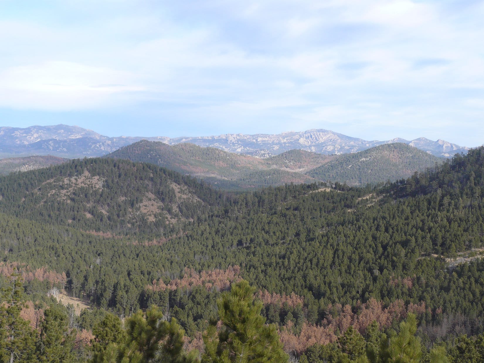
Lupe was now WNW of Northeast Cicero Peak. From the saddle ridge, another higher ridge was visible to the ENE. Most of that ridge was barren. It looked like it had been ravaged by a forest fire at some point in the past. Was that barren ridge Daisy Peak(5,948 ft.), Lupe’s 3rd peakbagging objective of the day? It seemed to be too close, but the ridge led N to a forested hill, which might well be Kruger Peak(5,838 ft.), Lupe’s 4th peakbagging goal of the day.
Lupe reaches the saddle ridge WNW of Northeast Cicero Peak. Photo looks ENE at another higher ridge that SPHP initially mistook for Daisy Peak.This photo shows High Point 5999 (on the Peakbagger.com topo maps), which SPHP initially mistook for Kruger Peak. Photo looks N from the saddle ridge WNW of Northeast Cicero Peak.
The saddle ridge WNW of Northeast Cicero Peak also provided a great view toward higher mountains to the N and NW.
Looking NNW from the saddle ridge WNW of Northeast Cicero Peak. Some of the highest peaks of the Black Hills are in view.
After taking in the views from the saddle area, it was time for Lupe to continue on up Northeast Cicero Peak. From Cicero Peak, SPHP had noticed a large grassy area that extended high up onto the SW part of the mountain. It couldn’t be too far away from where Lupe was now. Lupe and SPHP set off heading SE to look for it.
After crossing a level open area, Lupe had to climb steeply up through a thick forest of young trees where there was snow on the ground. Lupe emerged above the forest not far from the open area SPHP had seen from a distance. A short trek to the SW brought Lupe to it. There was a great view to the S of Cicero Peak.
Lupe SW of the summit of Northeast Cicero Peak. Photo looks S toward Cicero Peak.
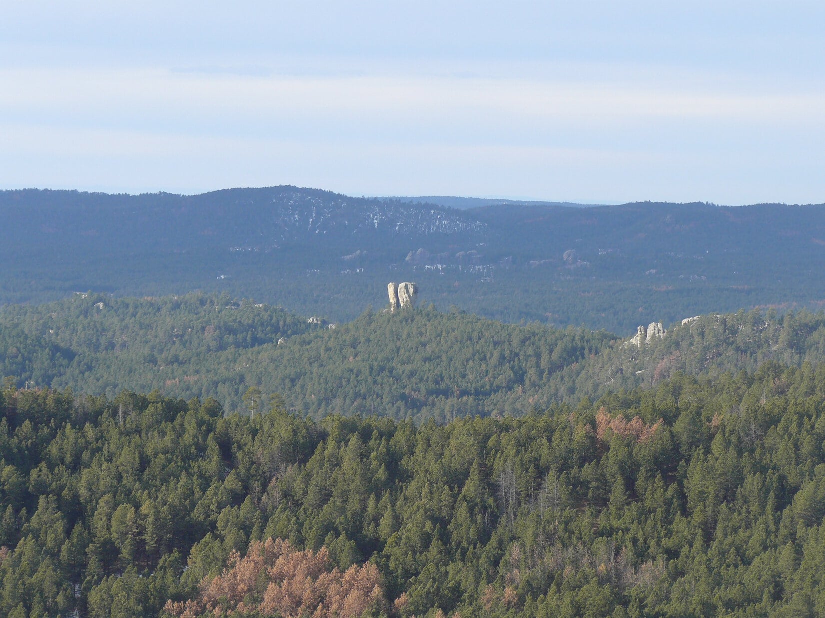
Back at Cicero Peak, SPHP had also caught a glimpse through the trees of an interesting little hill to the W capped by a rock that looked very much like a broken tooth. SPHP had dubbed it “Cracked Molar”. From where Lupe was now, SW of the summit of Northeast Cicero Peak, there was a clear view of Cracked Molar.
“Cracked Molar” from the SW slopes of Northeast Cicero Peak.
From the SW viewpoint, a 10 minute trek took Lupe up to the summit of Northeast Cicero Peak. The summit area was pretty broad and flat. Most of it was grassy, open ground. There was a little ridge of rocks just a few feet high, and several large boulders sitting around. There were great views in every direction, except to the S and SE where trees were in the way.
Lupe on the little rock ridge on top of Northeast Cicero Peak. The boulder that is the true summit, can be seen beyond Lupe near the trees. Photo looks ENE.Looking W from Northeast Cicero Peak. SPHP still hasn’t figured out what mountains those high peaks seen above Lupe’s back on the far horizon are.Lupe perches comfortably up on the boulder that is the true summit of Northeast Cicero Peak. Beyond Lupe on the L side of the photo is a half forested (L side), half barren (R side) hill, which was Lupe’s next peakbagging goal, Daisy Peak. Mt. Coolidge is seen just L of the dead tree on the R side of this photo. Photo looks NE.Daisy Peak (L) and Mt. Coolidge (R) from NE Cicero Peak. Photo looks NE.Harney Peak(7,242 ft.) (L) is the highest point on the horizon. Custer Mountain is the forested hill seen just below and slightly to the R of Harney Peak. Daisy Peak is on the R side of the photo. Photo looks N.
Looking N from Northeast Cicero Peak, SPHP really began to doubt that the high barren ridge and forested high point Lupe had seen from the saddle ridge down WNW of Northeast Cicero Peak were really Daisy and Kruger Peaks. They were just too close and easy to reach. On the other hand, if they weren’t Daisy and Kruger Peaks, where were they? Nothing else really stood out.
SPHP pondered the point as Lupe headed NE following a ridge down off Northeast Cicero Peak. The going was kind of slow. Rocks, dead timber, and scattered patches of snow were hidden in the grass. About halfway down to the next ridge (the one mistaken for Daisy Peak), SPHP stopped to check the maps. Lupe curled up near some rocks to enjoy the sunshine and get out of the breeze sweeping W across the ridgeline.
Lupe takes a sunny break out of the wind NE of Northeast Cicero Peak while SPHP checks the maps.
A look at the maps left no doubt. There was no way the high barren ridge Lupe was approaching was Daisy Peak, nor was the forested hill beyond it Kruger Peak. They had to be farther N, but another look in that direction left SPHP uncertain exactly which hills Lupe needed to head for. For a couple of minutes, SPHP considered just having Lupe turn around and return to the G6.
Nah! Lupe wasn’t going to turn around. The area was scenic and interesting. SPHP would figure out where Daisy and Kruger Peaks were eventually. It was an adventure, in any case, and Lupe was having fun. Onward!
The open ridge was a great place to be. There were views in every direction. Even well below the summit of Northeast Cicero Peak, Lupe was still quite high compared to much of the immediately surrounding terrain. There continued to be numerous rocks in the grass, though, and lots of fallen timber, too. To avoid tripping, SPHP had to stand still to look around.
Lupe reached the SSE end of the barren ridge. Lupe and SPHP headed for a small rocky prominence toward the NE. Time for a break. SPHP ate an apple, studied maps, and looked around trying to figure out where Daisy Peak was. Lupe had some Taste of the Wild.
Lupe at the break spot near the SSE end of the barren ridge. Photo looks NW.
OK. SPHP had it figured out. Daisy Peak was in sight off to the N. It had to be that hill well N beyond the forested hill SPHP had originally mistaken for Kruger Peak (actually High Point 5999). Kruger Peak wasn’t in view, but it was lower and probably hidden behind Daisy Peak. Now that it had been properly identified, from now on Daisy Peak was going to be easy to recognize. It was a rounded hill forested on the W side, and barren on the E side.
Daisy Peak was still quite a long way off. Time to get moving. Lupe and SPHP set off following the barren ridge NNW along the E side. Lupe eventually worked her way up to the highest point on the ridge. She continued NNW along the ridgeline from there.
The highest part of the barren ridge came to an end. Lupe and SPHP went W down a rocky slope toward a saddle leading up to High Point 5999. Partway down into the saddle, where the terrain became less rocky and not as steep, Lupe and SPHP paused. There were good views back S toward Northeast Cicero Peak, and N toward Daisy Peak.
Looking SSW back at Northeast Cicero Peak from partway down into the saddle over to High Point 5999. Part of the ridge Lupe and SPHP had followed coming down to the NE from Northeast Cicero Peak is seen toward the L.Daisy Peak is easily identifiable on the L. Lupe went all the way down to the bottom of the valley seen here on her way to climb Daisy Peak. Mt. Coolidge is the highest point on the R. Photo looks NNE.
SPHP could see that if Lupe continued following the spine of the saddle area up to High Point 5999, Lupe was going to have a long trek over a lot of rough ground. She would eventually have to lose elevation anyway, to get to Daisy Peak. Instead of climbing High Point 5999, Lupe and SPHP left the saddle area going N down into a big valley.
At first the route down was steep, rocky and full of dead timber. Gradually the going got easier. As Lupe approached a small forest in the valley, she came to a road. The road had been abandoned years ago. Trees were growing on it, but it made a great trail.
At the far N end of the valley, Lupe reached an intersection with another road going E/W. A marker showed that Lupe had been on USFS Road No. 337.1B. She had just reached USFS Road No. 337.1A, although there was no marker saying so. Lupe turned W (L) following No. 337.1A past a hill (High Point 5706) just to the N.
By the time Lupe was SW of High Point 5706, she was back in the forest. Here No. 337.1A turned SW, but Daisy Peak was still off to the N beyond High Point No. 5706. Lupe and SPHP left the road, and started climbing up the SW slope of High Point 5706. The terrain grew increasingly steep, and it became easier to just travel N along the slope.
Lupe and SPHP made it around High Point 5706 to the saddle that led up to Daisy Peak. Lupe went right on up the S slope to arrive at the summit. The true summit of Daisy Peak was out in the open near the S end of the summit ridge. There were good views from this grassy area in every direction except to the W and NW. Mt. Coolidge(6,023 ft.) was notable off to the NE.
Lupe on Daisy Peak. Photo looks NE toward Mt. Coolidge.Mt. Coolidge from Daisy Peak.Northeast Cicero Peak from Daisy Peak. Photo looks SSW.
Looking N from Daisy Peak, Lupe could finally see Kruger Peak. It wasn’t far off at all now, less than 0.5 mile. After a short rest break, Lupe headed N along the Daisy Peak summit ridge. Most of the ridge was forested, but at the very N end there was a great view of the big Glen Erin Creek valley and Custer Mountain(6,089 ft.) beyond it.
From Daisy Peak, Lupe could finally see Kruger Peak. It is the next hill over, and about 110 feet lower than Daisy Peak. Harney Peak is the highest point on the horizon. Photo looks N.Kruger Peak is the next mostly barren ridge dotted with small trees seen here to the N. The summit is in the larger trees toward the L side of this photo. Lupe was going over there next! Mt. Coolidge is seen on the R. Photo looks NNE from Daisy Peak.Custer Mountain is the forested hill seen on the L beyond the big Glen Erin Creek valley. Photo looks NNW from the N end of Daisy Peak.
To get to Kruger Peak, Lupe and SPHP started directly down the N slope of Daisy Peak. The going was slow, since the slope was fairly steep, snowy, and yet again there was a considerable amount of dead timber laying around. Lupe came across an old road down in the saddle area between Daisy and Kruger Peaks, but didn’t follow it. Instead, she just continued right on up to a high rocky point at the W end of the Kruger Peak summit.
Lupe perched on the highest rocks at the W end of Kruger Peak. This may not have been the true summit. Pictured between the trees is some ground to the E that looks slightly higher.
The rocks at the W end of Kruger Peak may not have been the true summit. There was an area a short distance E through the forest that was probably a little higher. Lupe went over there, too, to make certain she had reached the very top of the mountain. There were some rocks at the E high point, but they weren’t as impressive as those to the W.
By climbing Kruger Peak, Lupe had completed her 4th and final peakbagging goal of the day. She wasn’t going to go any farther N beyond Kruger Peak. The G6 was now 4 miles to the SSW as the crow flies. The E high point (and probable true summit) of Kruger Peak seemed like a good place to stop and take a break.
There was another reason to stop, too. Coming up Kruger Peak, Lupe had started hearing gunfire from down in the Glen Erin Creek valley to the W. It made her nervous, and she had been begging SPHP to stop and hide. So SPHP stopped and covered Lupe with a jacket so she would feel better. Lupe was happy and felt safe curled up under the jacket. SPHP ate an apple, checked the maps again, and took in the panoramic views to the E.
Daisy Peak from near the true summit of Kruger Peak. Photo looks SSW.
Lupe liked hiding under the jacket on Kruger Peak, but soon it was time to go. As SPHP led her down the E spine of the mountain, Lupe kept trying to persuade SPHP to stop again. Those big soft Carolina Dog ears could still hear gunfire far off to the W. The sun was starting to get low, though, and it was a long winding way back to the G6. Lupe and SPHP had to press on.
Lupe well down the E spine of Kruger Peak. Daisy Peak is seen on the R. Lupe traveled from here down into the valley below and over the saddle seen E (L) of Daisy Peak.
After losing quite a bit of elevation, Lupe and SPHP left the E spine of Kruger Peak. Lupe headed S down into a valley where she saw lots of deer. She headed for a saddle E of Daisy Peak. On the other side of the saddle, the land was forested and lost elevation again. Lupe had found a trail leading up to the saddle on the N side, and it continued down into the forest on the S side.
Daisy Peak from the NE.
The trail eventually led to USFS Road No. 337.1A. Lupe turned WSW (R) on it. She passed the junction with No. 337.1B, which she had come down earlier before climbing Daisy Peak. Lupe and SPHP just stayed on No. 337.1A all the way until it reached the main road, USFS Road No. 337. Although the sun was down by now, there were still a few active squirrels in the trees along the way, so Lupe had some exciting times barking as twilight closed in.
Just prior to reaching No. 337, Lupe came to half a dozen bearded men standing around a pickup truck. These were the first people Lupe and SPHP had seen since leaving the G6. The men were drinking beer, and for some reason, putting little branches of spruce trees in the empty beer bottles so they stuck out as if they were Christmas trees.
The men said they were from Custer. They weren’t hunters, just out drinking and talking in the woods having a good time. They were quite friendly. They treated Lupe kindly and offered SPHP a beer, which was politely declined. SPHP chatted with them for a few minutes. They seemed truly surprised to find out where Lupe had been.
Somewhere along USFS Road No. 337, Lupe got something stuck in her right ear. She kept shaking her head and scratching. SPHP tried to help her, but even with a flashlight couldn’t see anything in her ear. SPHP scratched it for her, which she enjoyed, but it didn’t really help. Lupe kept scratching it herself whenever SPHP stopped for more than a moment. Her ear bothered her off and on the rest of the day.
No. 337 led to No. 336 (Flynn Creek Road). No. 336 led to No. 338, the rocky road up to Cicero Peak. It was pitch dark by the time Lupe and SPHP reached No. 338. A red light could be seen up on the tower on Cicero Peak. As Lupe and SPHP made the trek up the mountain, SPHP threw 100 – 200 large loose rocks off to the side of the road, hoping to make the trip back down less traumatic for the poor, abused G6.
Before leaving Cicero Peak, Lupe and SPHP went all the way back up to the very highest rocks on the mountain, so Lupe could claim a 2nd ascent. At 6:06 PM (48°F), Lupe jumped into the G6 for the ride home. Despite SPHP’s rock clearing efforts, it still took 25 minutes to carefully drive the 1.5 miles back down the mountain, but the G6 emerged unscathed.
Black Hills, SD Expedition No. 109 was over. It was the last expedition for SPHP and the 3 year old Carolina Dog. Tomorrow was Lupe’s 4th birthday. Lupe’s last day being 3 years old had been quite a day!


 And that was it for Lupe in Glacier National Park. Since she couldn’t do much of anything here, it was time to start heading farther W! Due to the park regulations, it was settled – Lupe was going to see the Pacific Ocean!