Beluga Point, Portage Lake, the Byron Glacier & Cook Inlet of the North Pacific Ocean, Alaska (8-25-16)

Day 27 of Lupe’s Summer of 2016 Dingo Vacation to the Canadian Rockies, Yukon & Alaska

Everything hung on what the radio would say in the morning.  Yesterday evening, the rain had started in again in Palmer, Alaska before the light had faded completely away.  Every time Lupe woke up during the night, the relentless rain continued.  Once there was only fog, but that was hardly any better.

As near as SPHP could tell, the S coast of Alaska had already seen a solid month of rain and gloom.  A couple days ago, the forecast had been for 3 more days of rain, then clearing skies.  Lupe had left Palmer then, resigned to going all the way back to Canada.  Luckily, only an hour’s drive away, the skies had cleared enough so she could spend a couple days climbing Gunsight Mountain (6,441 ft.) and Lion Head (3,185 ft.).  Lupe was still in Alaska!  She had returned to Palmer hoping for the best.

Morning came.  Still raining.  For the 3rd time on this Summer of 2016 Dingo Vacation, SPHP cheated and turned on the radio.  If the forecast was unchanged, if the skies really were going to clear in only another day or two, Lupe would stay in Alaska.  On the other hand, if the forecast had been revised again to yet another vague promise of better days another 3 or 4 or 5 days in the future, this was it.  Lupe was abandoning hope, and going back to Canada.

Finally, the weather report came on.  Rain continuing throughout the day in Anchorage … yes, yes, and then? … clearing skies into the weekend, with highs near 70°F.  Click.  That was enough.  No Pepper Peak (5,381 ft.) today, but that was OK.  The clearing skies would likely be coming from the SW.  Lupe was going to greet them.  Well, Loopster, you lucky Dingo, you’re going to get to see Anchorage after all, and a whole lot more!

Anchorage was a big city, like other big cities.  Rush hour traffic slowed to a crawl for miles on the wet Glenn Highway due to an accident.  Downtown, SPHP missed the turn S on the Seward Highway, but managed to get back to it.  S of Anchorage, the rain was lighter.  Skies were still overcast, with occasional patches of fog.

The Seward Highway turned SE following the railroad right along the Turnagain Arm of the North Pacific Ocean.  At Beluga Point, Lupe and SPHP stopped for a look.

Lupe reaches Beluga Point on the Turnagain Arm of Cook Inlet, part of the North Pacific Ocean. Photo looks W.
Beluga Point is SE of Anchorage along the Seward Highway, which follows the coast of the Turnagain Arm. Photo looks NW.

Beluga Point is a popular place for watching Beluga whales.  Although the white whales are usually easy to spot, Lupe didn’t see any.  Several people at the Beluga Point pullout told SPHP they often saw whales here.  One claimed to have seen 28 Beluga whales during a single recent visit.

A powerful tide was coming in.  The strong, rippling current looked dangerous, as the ocean surged SE into the Turnagain Arm past Beluga Point.  Less than 10 miles away on the misty far shore, Lupe had her first glimpse of the Kenai Peninsula.

A powerful tidal current ripples past Beluga Point as the ocean surges SE (L) into the Turnagain Arm. On the far shore, Lupe could see the misty N coast of the Kenai Peninsula. Photo looks SW.
Looking S from Beluga Point.

Lupe and SPHP continued on.  The murky brown waters of the Turnagain Arm didn’t look very deep.  From the G6, Lupe saw huge expanses of exposed mud flats.  The incoming tide was in the process of inundating them again.  When the SE end of the Turnagain Arm came into view, Lupe made a brief stop at another viewpoint.

Near Girdwood, the SE end of the Turnagain Arm came into view. Photo looks SE.
Even on a cloudy, misty day, the scenery was beautiful. Photo looks SE at a glacier perched on a steep mountainside near the end of the Turnagain Arm.

The last several miles of the Turnagain Arm was nothing but mud flats and marshlands with a river flowing through it all.  Rounding the very SE end, Lupe and SPHP left the Seward Highway, turning E (L) on Portage Glacier Road.  Lupe didn’t take the road quite all the way to the Anton Anderson Memorial Tunnel to Whittier.  Instead, she went to see Portage Lake, bypassing the Begich Boggs Visitor Center along the way.

Lupe arrives at Portage Lake. The Portage Glacier used to fill this entire valley, but has since retreated out of sight behind the mountain on the R. Portage Lake is 3 miles long and up to 1 mile wide. Photo looks SE along 2/3 of the length of the lake.

Note: The Begich Boggs Visitor Center is located at the NW end of Portage Lake about 6 miles from the Seward Highway.  It was built in 1986 on the 1914 terminal moraine of the Portage Glacier.  The Portage Glacier used to be visible at the far SE end of the lake from the visitor center, but has since retreated out of sight.  Among other services, commercial boat tours to see the glacier are available at the visitor center.

The Portage Glacier can also be viewed from Portage Pass, accessed via a good hiking trail with 800 ft. of elevation gain.  From the pass, it is possible to hike on toward Portage Lake for a closer look at the glacier, which is less than a mile directly across the lake.  The turn to the Portage Pass trailhead is located on the SW (R) side of the road to Whittier about 0.25 mile after going through the 2.5 mile long Anton Anderson Memorial Tunnel.  A $13.00 round trip fee (passenger car, 2016) is charged to go through the tunnel.

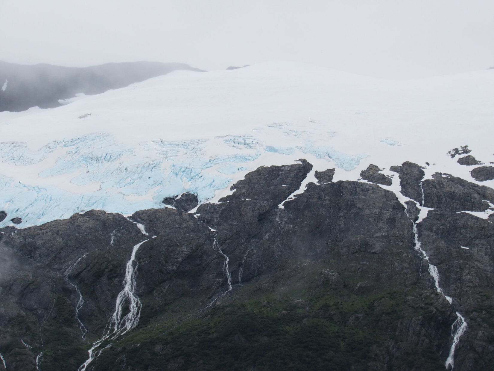
Even under drippy, overcast skies, Portage Lake was very beautiful.  On the opposite NE shore of the lake, Lupe saw waterfalls cascading down from a hanging glacier on Maynard Mountain (4,137 ft.).

Across Portage Lake, waterfalls cascaded down from a hanging glacier on Maynard Mountain. Photo looks NE.
Maynard Mountain from across Portage Lake. Photo looks NE.
From Portage Lake, Lupe could hear these waterfalls on Maynard Mountain, as well as others on nearby peaks. Photo looks NE using the telephoto lens.

Less than 0.5 mile before Lupe reached Portage Lake, she had passed by the trailhead to the Byron Glacier.  This easy trail with very modest elevation gain leads about a mile up a valley to the SW where the Byron Glacier can be seen.  Lupe and SPHP left Portage Lake to go check it out, parking the G6 at the trailhead (11:52 AM, 53°F).

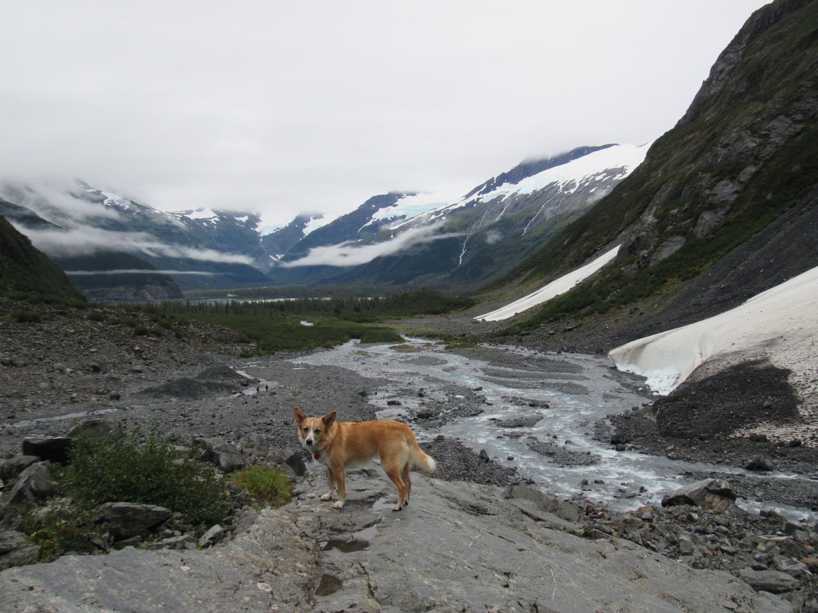
The first part of the trail was an easy stroll through a forest.  Meltwaters from the Byron Glacier formed a rushing stream on the SE side of the trail.  The trail did not cross the stream, but followed it up the valley.  When the trail left the forest, the Byron Glacier, which has retreated up onto the steep N slopes of Byron Peak (4,700 ft.), was in view ahead.

When the trail left the forest, the Byron Glacier was in view clinging to the steep N face of Byron Peak. Photo looks SW.
The Byron Glacier has retreated from the valley, and is now a hanging glacier. Photo looks SW using the telephoto lens.
The top of Byron Peak was hidden in the clouds, but most of the glacier was in view. Photo looks SW using the telephoto lens.

The official Byron Glacier trail ended at a low rock wall.  The trail was busy, even on this overcast day, and some people turned back here.  However, many went farther up the valley to get closer to the glacier, scrambling among the rocky terrain left by the glacier’s retreat.  Lupe and SPHP continued beyond the trail’s end, too.

Lupe on the low rock wall at the official end of the Byron Glacier trail. The glacier has retreated so far that the end of the trail is no longer all that close to the glacier. Photo looks SW.

The Byron Glacier is famous for having accessible ice caves.  Lupe didn’t go that far, but she did go beyond the official end of the trail far enough to see what appeared to be a large ice cave ahead.

Lupe went far enough up the valley to where she could see what looked like a large ice cave ahead. Photo looks SW.
The ice cave looked less like a cave through the telephoto lens, but maybe there was a cave up there somewhere. What was clear was that the Byron Glacier was larger than it looked. A lot of snow and ice was hidden beneath rocks and debris. Photo looks SW.

The closer Lupe got, the easier it was to see the blue ice high up on the Byron Glacier.  The glacier was a beautiful sight with the gorgeous blue and white ice above, and waterfalls plunging down the gray mountainside below.

The Byron Glacier was a gorgeous sight with blue and white ice above, and waterfalls plunging down the gray mountainside below. Photo looks SW.
Love that glacial blue ice!

Lupe explored up the valley far enough to where she could look back down and see Portage Lake surrounded by mountains in the distance.

Looking back down the valley, Lupe could see Portage Lake surrounded by mountains in the distance. Photo looks NE.
Meltwaters from the Byron Glacier stream toward Portage Lake. The waters will eventually leave Portage Lake flowing only 6 miles NW to the Turnagain Arm of the North Pacific Ocean. Photo looks NE.

Lupe and SPHP returned to the G6 (1:51 PM).  Even at a leisurely pace, the easy trek to see the Byron Glacier had only taken a couple of hours.  At least it had given Lupe a chance to get some exercise.  Most of the rest of the day would be spent in the G6 looking for those sunny skies.

SPHP drove back to the Seward Highway and turned S (L).  Almost immediately, the highway curved around to the NW.  A few miles later, it turned SW where a big sign welcomed Lupe to the Kenai Peninsula!

Lupe reaches Alaska’s Kenai Peninsula.

The drive through the Kenai Peninsula was gorgeous.  Lupe saw forests, towering mountains, big lakes and rivers.  At a junction, SPHP took the Sterling Highway toward Soldotna.  Lupe passed Kenai Lake, traveled for miles along the beautiful blue-green Kenai River, saw the turnoffs for huge Skilak Lake and the Russian River where bears fish for salmon.

A few miles after passing the Mystery Hills trailhead, the Sterling Highway left the mountains.  This part of the Kenai Peninsula was low, forested, flat, and dotted with lakes and marshlands.  Sterling was hardly noticeable as a community, but Soldotna was a thriving, busy place.  A quick stop for supplies at the Safeway in Soldotna, and Lupe continued on.

The Sterling Highway headed SW from Soldotna, eventually reaching bluffs above the Cook Inlet of the North Pacific Ocean.  By now the skies had cleared.  At last, Lupe basked in sunshine!  Perched along the bluffs overlooking Cook Inlet were homes, campgrounds, RV parks and restaurants.  They all had a stupendous view.

Far to the W across Cook Inlet was a grand, lofty mountain.  At first, SPHP wasn’t sure what mountain that was, but Lupe was seeing the highest peak of the Aleutian Range, the Redoubt Volcano (10,197 ft.), for the first time.

SW of Soldotna, the Sterling Highway reached bluffs above the Cook Inlet of the North Pacific Ocean. Far away to the W, on the other side of Cook Inlet, Lupe saw a grand, lofty mountain – the Redoubt Volcano! Photo looks W.

Near the tiny village of Ninilchik, SPHP left the highway to drive a couple miles down a deeply potholed road to the beach.  Lupe and SPHP left the G6, and walked down to the shore of Cook Inlet.

Bathed in evening sunlight, Lupe reaches Cook Inlet of the North Pacific Ocean near the tiny community of Ninilchik. Redoubt Volcano is very faintly seen on the far horizon straight up from Lupe’s head. Photo looks NW.

Faintly, beyond the shining sea, Lupe saw not just one, but two magnificent peaks!  To the NW was the Redoubt Volcano, which she had already glimpsed from the highway.  To the W was another glacier-covered stratovolcano, nearly as high, the Iliamna Volcano (10,016 ft.).

Redoubt Volcano from the Cook Inlet beach at Ninilchik. Photo looks NW using the telephoto lens.
Across the shining sea was a 2nd magnificent mountain, the Iliamna Volcano. Photo looks W using the telephoto lens.

Lupe had seen the ocean twice already on her Summer of 2016 Dingo Vacation, once at Hyder, Alaska on her trip to see the Salmon Glacier, and then again earlier today at Beluga Point.  At Ninilchik, though, for the first time since she was only 1.5 years old during her 2012 Dingo Vacation to the West Coast, Lupe got to go for a walk along the ocean.

Here at Ninilchik, a happy Lupe got to go for a walk along the ocean for the first time since she was only 1.5 years old on her 2012 Dingo Vacation to the West Coast. She went as far as the end of the bluff seen in the distance. Photo looks SW.

SPHP wondered if Lupe remembered playing at the ocean?  Did she remember what a fabulous time she had on the West Coast in 2012 racing along the beach, while barking at seagulls flying overhead?  At first, Lupe seemed uncertain about the ocean, but somewhere in that Dingo mind, she did recall something.

Soon she was watching for seagulls again, but saw only one fly by.  She made up for it by barking at some crows.  Loop began to run around exploring, stopping to sniff the very strange smells of seaweed, dead crabs, and other things washed up on the beach.  She remained cautious, though, when it came to the cold waves rolling in to shore.  She was careful not to let more than her paws get wet.

Lupe looks out to sea, being careful not to let more than her paws get wet in the cold water. If Lupe had been here 238 years earlier in late May, 1778, she might have seen the HMS Resolution sail by under the command of famous explorer Captain James Cook on his search for the fabled Northwest Passage.
Exploring the beach.

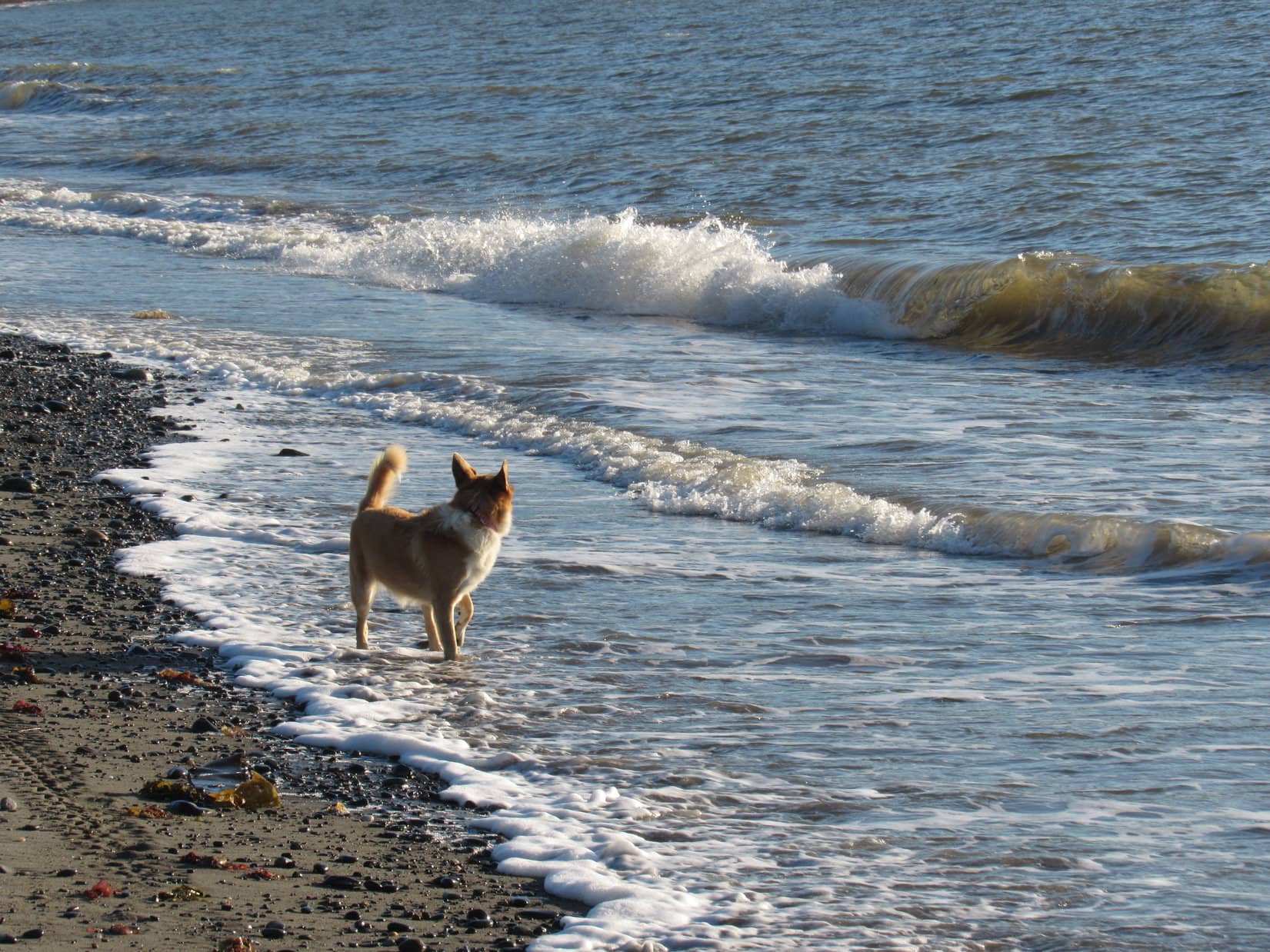
The evening stroll along Cook Inlet was fantastic!  Living in the Black Hills of South Dakota more than 1,000 miles from any ocean, being here was a rare treat.  The glowing sunlight, the sound and motion of the surf, and the distant wild mountains of Alaska on the far shore watched over by the giant Redoubt and Iliamna Volcanoes were an unforgettable combination.

Lupe went SW along Cook Inlet as far as Deep Creek, right across from Cape Ninilchik.  She was perhaps 2 miles from where she’d started near Ninilchik village.  Then it was time to turn around, and enjoy it all over again.

Lupe on the shore of Cook Inlet. Buildings back at the village of Ninilchik are seen on the far bluff. Photo looks NE.

A woman was searching for her lost 9 year old dog named Ola, when Lupe and SPHP neared Ninilchik again.  Unfortunately, Lupe and SPHP hadn’t seen Ola, and couldn’t help her.  Lupe’s fur was full of sand from her romp on the beach, so SPHP drove her over to a campground to rinse it off.

It wasn’t long until sunset now, but there was still time to go take a look at Ninilchik’s most famous building.  On a steep bluff above the village of Ninilchik sits a Russian Orthodox church dedicated on this site in 1901.  Lupe and SPHP went to pay it a visit.  When Lupe arrived, the lady looking for Ola was there, too.  Someone had seen Ola not too far from here a short time ago.

Since Ola was likely to be found soon, Lupe went on to take a look at the little church.

This Russian Orthodox church sits on a bluff above the village of Ninilchik.
The church was closed, but Lupe at least got to sit on the front porch.

The churchyard seemed to double as a graveyard with many white crosses around. The grounds also featured a profusion of flowers.

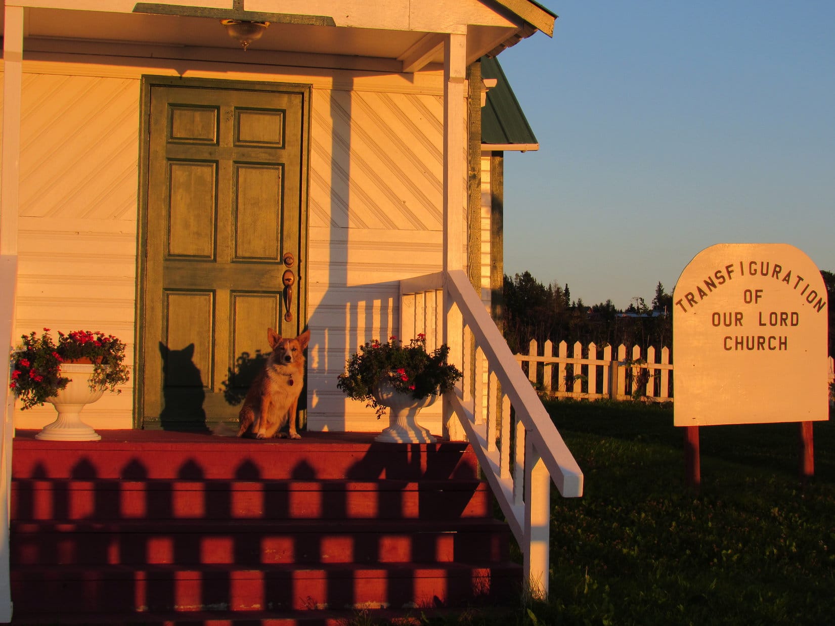
The Russian Orthodox church was a quaint reminder of the Russian origins of Ninilchik back in the 1800’s before the United States purchased Alaska from Russia.  Lupe had a good time sniffing among the many flowers growing in the churchyard, but she couldn’t stay long.

Before the sun was down, Lupe returned to the beach on the Cook Inlet.  A handful of other people and dogs were around (though not the elusive Ola), too.  Everyone was gathered here to enjoy sunset over Cook Inlet and the mountains on the far shore.

Iliamna Volcano from Ninilchik near sunset. Photo looks W using the telephoto lens.
Lupe made it back to the beach on Cook Inlet near Ninilchik with little time to spare before sunset. Redoubt Volcano can be seen beyond Lupe. Photo looks NW using the telephoto lens.
Cook Inlet and Redoubt Volcano. Photo looks NW.
Cook Inlet and Iliamna Volcano. Photo looks W.

Sunset at Ninilchik was an amazingly beautiful and peaceful time.  Everyone was friendly and happy.  Lupe had found her sunshine at last, after many long days of trying to dodge, or wait out, frequent rain beneath dark skies.

Sunset over Cook Inlet from Ninilchik. Iliamna Volcano on L. Photo looks W.
Carolina Dog, Lupe was 238 years too late to see Captain James Cook of the British navy sail by on his search for the Northwest Passage, but at least she was here now to discover Cook Inlet for all American Dingoes!
Day’s end at Cook Inlet, Ninilchik, Alaska. Photo looks WNW.
Iliamna Volcano.
Redoubt Volcano.

And then it was over.  The last rays of sunset disappeared from view.

The sun was down, but Lupe’s day wasn’t over yet.  As golden twilight faded to night, SPHP drove SSW on the Sterling Highway.  Near Anchor Point, Lupe was running out of land farther W on the Kenai Peninsula.  The road curved S, then SE.

It was 10:30 PM, by the time Lupe rolled into Homer.  Her next big Alaska adventure would start here.  Today, Lupe had reached and enjoyed time spent along the North Pacific Ocean at Cook Inlet.  Tomorrow, if the weather held, explorer Lupe would set sail.

Links:

Next Adventure                         Prior Adventure

Want more Lupe adventures?  Choose from Lupe’s 2016 Canadian Rockies, Yukon & Alaska Adventure Index, Dingo Vacations Adventure Index or Master Adventure Index.  Or subscribe free to New Lupe Adventures.

Black Hills, SD Expedition No. 193 – Seven Sisters Range High Point, Peak 4371 & Peak 4310 (2-27-17)

Good grief!  The temperature, already chilly enough back at home, was dropping instead of rising.  Maybe a Black Hills expedition today wasn’t such a great idea after all?  Lupe had been as enthusiastic as always, though.  Hopefully the morning would warm up as forecast.  This afternoon it was supposed to get a little above freezing, a heatwave compared to the 14°F the G6 was registering.

By the time Lupe was on East Cascade Mountain Road off Hwy 71 approaching the Seven Sisters Range High Point (4,420 ft.), the G6 said it was 20°F out.  Better, but still a crispy start.  SPHP parked the G6 just N of the junction with Big Buck Boulevard (7:49 AM).  A few minutes later, Lupe had permission to enter and inspect the private property to the E.

The Seven Sisters Range High Point is dead ahead. Photo looks E along East Cascade Mountain Road.

20 acres were for sale by owner E of Big Buck Boulevard.  The property was all barb wire fenced and had a small, partially finished cabin on it.  The acreage was tucked in a scenic spot at the base of the Seven Sisters Range High Point, and went partway up the mountainside.  Although some of the land was a bit steep and rocky, most of it was horse pasture.  The asking price was $100,000.

Lupe starts her inspection of the 20 acres for sale W of the Seven Sisters Range High Point. Photo looks ENE.

Two horses were supposedly on the property.  Lupe saw no sign of them, but did see horses in pastures to the N and S.  Cows at a cattle operation W of Big Buck Boulevard were mooing loudly.  The property had an ambiance that an American Dingo could certainly appreciate!  Lupe went to sniff around the little cabin.  She got up on the deck that faced N toward the best view.

The cabin was 7 years old, but only partially completed.  No heat, no power and no water.  Kind of a Spartan existence.  Lupe couldn’t go inside, and it didn’t take her long to complete her outside inspection.  She left the cabin to head up the mountain for an even better look at the view.

After inspecting the rustic cabin, Lupe climbed higher up on the 20 acres for a better look at the views. Lupe knew people looking for horse property in the Black Hills. Maybe she could earn a finder’s fee? She was disappointed when SPHP explained that she lacked the necessary real estate license. Photo looks W.

Lupe kept climbing.  The higher she went, the better the views were.

A wintery view from the upper W slopes of the Seven Sisters Range High Point. Peak 4371 is seen on the L. Photo looks SSW.

Lupe reached the top of the W face of the mountain near the N end.  For the most part, trees hid the views.  Lupe could no longer see the little cabin, but managed to find a few gaps between the trees from which she could see off into the distance.

Looper at the N end of the W face of the mountain. Photo looks WSW.
Looking N.

The mountain’s true summit was clearly farther S, somewhere close to the edge of the W face.  Loopster led the way S to go look for it.

The high point is this way, SPHP! Come on! Photo looks SSE.

Winter had made a comeback in the past week.  It certainly felt like February again!  When Lupe came to a small snow-free patch of ground before even reaching the high point, SPHP called a halt.  Time to warm up!  Lupe huddled inside SPHP’s jacket.  She was shivering a little.  SPHP took off a shoe to warm up a foot.

After a few minutes resting quietly, Lupe tensed up.  Off to the NE, a herd of deer was running through the snow.  Although quite a distance away, the deer were of keen interest to the Carolina Dog.  Lupe watched excitedly until the last deer disappeared into the forest.

When Lupe quit shivering and SPHP’s foot had warmed up, it was time to carry on.  The high point couldn’t be much farther.

Lupe stands next to the little bare patch of ground where she stopped to warm up inside SPHP’s jacket. She’d enjoyed watching a herd of deer running through the snow in the thinly treed area down the slope seen behind her. Photo looks NE.
Lupe stands at a viewpoint only 20 feet from where she’d warmed up at the bare patch of ground. Peak 4371 is the closest big ridge on the L. Photo looks SSW.

The Seven Sisters Range High Point (4,420 ft.) wasn’t far from where Lupe had warmed up.  The summit area turned out to be quite large, 200 – 300 feet long N/S and not quite as wide E/W.  The whole area was thinly forested.  The terrain was so flat it was hard to discern any definite exact highest spot among the snow drifts.

The best views were along the edge of the steep W face of the mountain, though the ground seemed slightly higher a little farther E.   Lupe toured the summit area hoping to find a squirrel in one of the trees, but it was so cold out any squirrels must have been curled up in their holes and wrapped in their bushy tails for warmth.

Lupe reaches the Seven Sisters Range High Point. The summit area was large, thinly forested and quite flat. Photo looks SSW toward Peak 4371.
Looking WNW from along the W rim of the summit area.
Lupe stands at what seemed to be the true summit of the Seven Sisters Range, although there was a lot of ground around very nearly as high. Photo looks WSW.

Disappointed by the lack of squirrels, Lupe continued S near the W rim of the mountain.  Grand open vistas were on display to the SW.  Under the overcast sky, the snow made the scene look clean and white, remote and desolate.  What a great place to be!  Off to the E, South Knapple Canyon was in view.

Looking E down South Knapple Canyon. The high prairies of western South Dakota are seen beyond the edge of the Black Hills.

When Lupe got to the area near High Point 4360 on the Peakbagger.com topo map, she had a clear view of her next peakbagging objective, Peak 4371, ahead.

When Lupe reached the area near High Point 4360 toward the S end of the Seven Sisters Range High Point, she had a clear view of Peak 4371 ahead. Photo looks SW.
Looking back toward the summit of the Seven Sisters Range from near High Point 4360. The sky was dark off to the NW (L) where a snow shower was going on. Photo looks N.

Beyond High Point 4360, the ridgeline turned SE.  Soon Lupe could see far below a snowy pass she would have to traverse to get to Peak 4371.

SE of High Point 4360, Lupe came to this overlook where she could see the snowy pass leading to Peak 4371.

As Lupe continued SE, she discovered a snow-covered road.  The road descended gradually at first, but became steep, rocky, and soft as it made a sharp turn down to the pass.  Following the road made it much easier for Lupe to get down to the pass than it would have been otherwise.

The road did not continue up Peak 4371.  Upon reaching the pass, Lupe left it.  She enjoyed a snowy romp over to the base of Peak 4371’s NE ridge.  The NE ridge was the steepest part of the climb up the mountain, but wasn’t bad at all.  When Lupe was halfway up, the ridgeline turned W gaining elevation at an easier pace.

Peak 4371 had looked fairly heavily forested from a distance.  SPHP wasn’t certain if Lupe would find any clear views from the top.  On her way up the W ridge, Looper agreed to pose for a photo at nice viewpoint, just in case the summit was buried in trees.

The Seven Sisters Range High Point from the NE ridge of Peak 4371. Photo looks N.
Lupe on her way up Peak 4371. She is on the upper E ridge here, with a great view of the Seven Sisters Range High Point to the NNE.

Lupe didn’t reach the summit of Peak 4371 until she made it all the way to the far W end of the mountain.  The summit area here was much smaller than at the Seven Sisters Range High Point, though there was still plenty of room to move around.  The whole area sloped moderately down toward the E.  A rock very close to the W edge of the mountain was clearly the true summit.

Success! Lupe stands on the rock that’s the true summit of Peak 4371. Photo looks SW.
Lupe still perched on Peak 4371’s summit rock. This photo shows a little wider view of part of the summit area. Peak 4310 is the next snowy ridge seen on the L. Lupe was going there next! Photo looks SSW.

Trees were at the summit of Peak 4371, but the top of the mountain wasn’t buried in them as SPHP had feared.  Views could be seen in most directions, although Lupe often had to move around a bit to get a clear look.  The whole summit area was only 50 or 60 feet in diameter, so it didn’t take Lupe long to explore it.

Loopster on another rock along the W rim of Peak 4371. Photo looks NW.

The best view from Peak 4371 was a sweeping panorama to the SSW.  Lupe was fortunate to be here on a day when the white snow made the scene particularly beautiful.  Lupe could see her next peakbagging objective, Peak 4310, plus a couple other peaks of interest.

Peak 4310, the nearest snowy ridge and Lupe’s next peakbagging objective, was in clear view from Peak 4371. Photo looks SSW.
Lupe was fortunate to be on Peak 4371 on a day when the snow made the scene so beautiful and grand! Snowy Peak 4310 (L) is in view close by. The highest point in the distance on the far L is Flagpole Mountain (4,320 ft.). The most distant of the low ridges in the foreground on the R may be part of Devil’s Slide Mountain (3,965 ft.). Photo looks SSW using the telephoto lens.
A wider look at Peak 4310 nearby. To get there, Lupe would have to go all the way down to the big treeless patch of snow seen at Center below. From this pass, she could follow a road going first SW (R) then SE (L) up the mountain. Photo looks S.

Lupe left the summit of Peak 4371 following the SE ridge.  She was losing elevation steadily, but it was soon apparent that she was going to have to lose it even faster.  Below to the S, she could see the wide pass leading to Peak 4310.  The slope leading down to it was rather steep.

This time there wasn’t any road to follow.  Lupe started directly down the steep S slope.  She had barely left Peak 4371’s SE ridgeline, however, when suddenly Lupe wanted to stop.  Exactly why wasn’t clear.  Nevertheless, only 10 or 12 feet below the edge of the ridge, Lupe and SPHP stopped to rest on a small rock ledge.

Even though it had warmed up enough to be helpful by now, SPHP let Lupe huddle inside the jacket.  She wasn’t shivering, though, like last time.  Maybe she had stepped on a cactus under the snow?  Maybe she had heard something that had made her nervous?  Her reason for wanting to stop wasn’t clear, but Lupe seemed happy resting right here.  At least the view of Peak 4310 was splendid.

Lupe on the little rock ledge she wanted to stop at for a while on the upper S slope of Peak 4371. The view of Peak 4310 to the SSW was splendid from here.

Another idea.  Maybe Lupe was hungry?  She was!  She devoured an entire bowl of Taste of the Wild.  The poor Carolina Dog was famished!  Climbing two mountains already had built up an appetite.

While Lupe was crunching happily away, SPHP noticed what appeared to be a structure near the W end of Peak 4310 where the true summit was supposed to be.  A house or some sort of outbuilding?  A tower was in view near it, too.  Using the camera’s telephoto lens, SPHP saw that the structure was a shed of some sort, not a home.  A road could also be seen winding up the NW side of the mountain to reach a high saddle E of the true summit.

Even after dining, Lupe was perfectly content right where she was.  However, it was time to press on.  Puppy, ho!  Picking a way down the steep, snowy slope took a while, but Lupe made it down to the pass.  From the pass, she took the road up to the high saddle in the middle of Peak 4310.  On the other side of the saddle, off to the SE, was another surprise.  A rather nice cabin was situated in a wooded area.

Peak 4310 has two high points at opposite ends of the mountain.  The true summit is to the W.  Slightly lower High Point 4304 is to the E.  Lupe went to check out High Point 4304 first, passing to the N of the hidden cabin.

At High Point 4304, Lupe found a large rock.  From it, she had a great view to the SE down Red Canyon.  She could see Angostura Reservoir, the largest lake in the Black Hills region.  The lake is formed by a dam on the Cheyenne River.

Lupe on the big rock at the top of High Point 4304. Photo looks SE down Red Canyon toward frozen Angostura Reservoir.
Another look at Angostura Reservoir using the telephoto lens. Photo looks SE.

The view toward Angostura Reservoir was the best, but Loop could also see Flagpole Mountain (4,320 ft.) to the S.

Flagpole Mountain is the distant high point straight up from Lupe’s head. Photo looks S.

Having seen what there was to see from High Point 4304, Lupe headed W to visit the true summit of Peak 4310.  She passed by the hidden cabin again.

Lupe passed to the N of this rather nice cabin on Peak 4310 both on her way to and back from High Point 4304. Photo looks SW using the telephoto lens.

Although Peak 4310 was the lowest hill Lupe climbed on Expedition No. 193, the true summit was the most barren and open here.  Consequently, the views were amazing!  The summit area was larger than Peak 4371’s, but smaller than at the Seven Sisters Range High Point.

Although Peak 4310 was the lowest of all the peaks Lupe climbed on Expedition No. 193, the views were simply amazing. A beautifully wintery look at Sheps Canyon is seen here. The high point in the distance L of Center is Flagpole Mountain (4,320 ft.). Photo looks S.
This photo shows much of the summit area at the W end of Peak 4310. Lupe found the highest rock on the mountain near the trees on the L. Photo looks N.
Another look at Angostura, this time from the W end of Peak 4310. Photo looks SE.
The great view to the WNW.

With fantastic views in practically every direction, Lupe and SPHP lingered on top of Peak 4310 longer than anywhere else.  A medium-sized flat rock was at the true summit of the mountain.  Lupe and SPHP sat here for a while admiring the wintery scenes all around.  SPHP ate an apple.  Lupe sat contently on SPHP’s lap, enjoying being petted and adored.

Lupe stands on the flat rock at the true summit of Peak 4310. For a minor Black Hills peak, the views were outstanding! Photo looks WSW.
At the N end of the summit area, Lupe had this fabulous view back to the N. Peaks 4371 and the Seven Sisters Range High Point are seen on the R.
Looking NW.

Upon reaching Peak 4310, Lupe had achieved all of her primary peakbagging goals for Black Hills, SD Expedition No. 193.  Yet the position of the sun, seen dimly through the clouds, indicated it was only mid-day.  Lupe had a few secondary goals in the general area.  Maybe she still had time to climb another peak, if she got back to the G6 soon enough?

After the apple was gone, Lupe and SPHP spent an extra 10 minutes on Peak 4310, simply wandering around looking at all the splendid views again.  Before departing, Lupe returned to the rock at the true summit.  It was a little sad to be leaving such a great place.

Before departing, Lupe returned to the rock at the true summit of Peak 4310. Photo looks SE.

To return to the G6, Lupe had to retrace her entire route.  She took the road from the high saddle on Peak 4310 all the way back down to the pass leading to Peak 4371.  She climbed Peak 4371’s steep S slope, passing by her prior rest stop at the little rock ledge just below the SE ridgeline.  Here she turned for one last look at Peak 4310.  It was as beautiful as a Christmas card.

Looking back at Peak 4310 for a final time, it was as beautiful as a Christmas card. Photo looks SSW.

Since it was on her way, Lupe tagged the rock at the true summit of Peak 4371 again.  Then she went back down the E ridge along the N side of the mountain.  Where the E ridge angled NE, the Carolina Dog climbed up on a big rock outcropping for yet another look around.

Lupe returns to the rock at the true summit of Peak 4371 to complete her 2nd ascent of the mountain on Expedition No. 193. Photo looks NW.
Partway down the E ridge of Peak 4371, Lupe got up on this big rock formation. From here, the ridge turns NE and drops more steeply down to the pass leading to the Seven Sisters Range High Point. Photo looks SE.
This American Dingo can be encountered almost anywhere in the Black Hills of South Dakota. No need to exercise any special caution, however. Dingoes are wary, but extraordinarily friendly once you get to know them.

As Lupe continued down the NE ridge to the next pass, the sun made its best effort of the day to break through the clouds.  Patches of blue sky began appearing.  The day felt warmer.  Snow softened and began to melt.

As Lupe came down Peak 4371’s NE ridge, patches of blue sky appeared. As the sun tried to break through the clouds, it became noticeably warmer out. Photo looks N toward the Seven Sisters Range High Point.

Down at the pass, Lupe got back on the road leading up to the Seven Sisters Range High Point.  Approaching High Point 4360 again, she saw another herd of deer up there.  The Carolina Dog raced off to investigate, perhaps with the intention of procuring dinner, but the deer had a huge head start on her.  They were long gone well before she reached High Point 4360.

As far as Lupe was concerned, it was still an exhilarating experience!

Lupe comes running back from High Point 4360. No venison for dinner, not even close, but it had still been a fun romp. Hope springs eternal in a Carolina Dog’s heart!

SPHP went back up to High Point 4360 with Lupe to see where the deer had been.  No telling if this had been the same herd Lupe saw early in the day when she stopped at the snow-free spot to warm up.  Probably not, since this was the opposite S end of the mountain, and those deer had been heading N.

Back to the road.  Lupe didn’t have much farther to go to reach the Seven Sisters Range High Point again.

Approaching the Seven Sisters Range High Point. This time coming from the SSE.

Lupe had to leave the road to return to the Seven Sisters Range High Point summit.  Another mountain successfully ascended for a 2nd time today!

This time, Lupe didn’t linger very long.  She already knew there weren’t any squirrels to be found here!  She continued N along the scenic W rim of the mountain.

The sunshine hadn’t lasted long. By the time Lupe made it back up to the summit of the Seven Sisters Range, the sky was overcast again. Photo looks W from the W rim of the mountain.

Lupe went all the way back to the N end of the mountain for a final look at the view there.  Then she started down the W slope where she had originally come up early in the day.  SPHP took a long time to picking a way down the steep slope, but Lupe eventually arrived back at the rustic cabin and 20 acres for sale (2:04 PM, 35°F).

With 3.5 hours left before sunset, it seemed like Lupe ought to be able to climb another peak today.  However, the G6 fell just short of making it up a long snowy slope on West Cascade Mountain Road.  SPHP wasn’t even certain this was the way to Peak 4340, so decided to forget this one until the snow was gone.  Miles farther N, the road to Peak 4160 was a muddy, sloppy mess.

So that was it.  No more peaks.  Expedition No. 193 was over.  Oh, well!  Lupe didn’t care.  She had a wonderful time barking at cows and horses all the way home.  SPHP didn’t really care either.  What a wonderful day it had already been, roaming the Seven Sisters Range with the plucky Carolina Dog, exploring an unexpectedly gorgeous part of Lupe’s world!

At the N end of the W rim of the Seven Sisters Range High Point, Lupe’s last stop before heading down to the G6. Photo looks WSW.

Links:

Next Black Hills Expedition                  Prior Black Hills Expedition

Want more Lupe adventures?  Choose from Lupe’s Black Hills Expeditions Adventure Index or Master Adventure Index.  Or subscribe free to new Lupe Adventures.