Day 30, Part 2 of Lupe’s Summer of 2016 Dingo Vacation to the Canadian Rockies, Yukon & Alaska
Flashing lights. SPHP slowed down, pulling over toward the shoulder to let the cop go past. Instead, the patrol car came right up behind the G6. Uh-oh. SPHP had been driving 10 mph under the limit. Now what? Lupe started to growl as the policeman approached SPHP’s window. Not a good time for that, Looper! Shush!
Burnt out headlight. Which one? The right one. Good grief. That same headlight had burnt out a few weeks before Lupe left home on this Dingo vacation. SPHP had personally bought and installed a new bulb. Most aggravating.
The officer politely gave SPHP a $50 fix-it ticket. Fix it within 30 days and have the headlight inspected by an Alaskan state trooper, or pay the fine. Sigh. Well, onward. Nothing could be done about it on a Sunday evening. Loopster, that was an adventure we could have done without.
The adventure Lupe was on her way toward was the trail to Portage Pass to see the Portage Glacier. Only a few days ago, Lupe had seen Portage Lake and taken a nearby trail to see the Byron Glacier. However, Portage Glacier long ago receded from view from the NW end of Portage Lake where Lupe had been. To see it, Lupe would have to go through the Anton Anderson Memorial Tunnel (also known as the Whittier Tunnel), and take the trail to Portage Pass.
At 13,300 feet long (2.5 miles), the Anton Anderson Memorial Tunnel is the longest highway tunnel in North America. The tunnel is only a single lane wide, and highway vehicles share it with the Alaskan Railroad. Railroad tracks are embedded right in the highway lane.
Logistically, the tunnel functions on a set schedule, with highway vehicles getting to use the tunnel for 15 minutes in each direction each hour. The 15 minute intervals alternate directions every 30 minutes. The tunnel is not open to highway vehicles at night. During 2016’s summer schedule, the first time slot in the morning was 7:00 – 7:15 AM. The last time slot in the evening was 11:00 – 11:15 PM.
Lupe timed her arrival at the Whittier Tunnel perfectly! SPHP paid the $13.00 round trip fee for the G6 at the toll booth. Only a minute or two later, Lupe had a green light to enter the tunnel.
The 2.5 mile long Anton Anderson Memorial Tunnel to Whittier was more fun and spooky than Lupe expected!
The maximum speed limit was only 25 mph, so it took a while to get through the tunnel. It was spookier and more fun than Lupe expected! It was a little like going down a long dungeon passage in a video game, except there were no side doors, passages, turns or curves at all. (No wandering monsters, either!) The tunnel was completely straight.
In a few places, water dripped from the ceiling. At intervals, there were small pullouts for vehicles experiencing mechanical difficulties. Otherwise, no stops are permitted. If a train had been coming from the other direction, the Whittier Tunnel would be the stuff of nightmares.
The tunnel was a little like being in a long dungeon passage in a video game, except there were no side doors, passages, twists or turns at all. The Anton Anderson Memorial Tunnel is completely straight.
Of course, the tunnel’s carefully controlled schedule prevents head on collisions from happening. Still, it was an odd feeling when, upon emerging from the tunnel, Lupe saw a locomotive aimed directly at the passage she had just taken.
Lupe was now on the Whittier side. Only a short distance (0.25 mile?) from the end of the tunnel, was a R turn onto a gravel road that promptly went over the railroad tracks. This was the short road leading to the Portage Pass trailhead. Another R turn led to a lane where vehicles were parked along both sides of the road. It was a strange trailhead with no formal parking lot. At first, SPHP wasn’t even certain Lupe was at the right place.
This was it, though! SPHP parked the G6 (7:02 PM, 57°F). Tall bushes dominated the area, and out of them flooded a horde of tiny black flies. Standing around meant getting chewed on by these little menaces. Lupe and SPHP looked around for the trail to Portage Pass, finding it near a sign. Lupe set off up the trail at once.
The Portage Pass trail was relatively busy, with people and dogs coming and going. Most were leaving at this time of day. Tall bushes grew everywhere off the trail. Biting black flies were everywhere, too. They weren’t too bad, as long as Lupe didn’t stop to look around. Going up the trail to Portage Pass, there really wasn’t much to stop and look at anyway, although the view back toward Whittier and Passage Canal was steadily improving as Lupe gained elevation.
The trail to Portage Pass is only a mile or so long. The trail is popular, so it was well-worn and in good condition. It starts close to sea level, and gains nearly 800 feet of elevation. Most of the way, it climbed steadily at a moderate pace. As Lupe neared the pass, the climb became steeper. The annoying black flies did an excellent job of discouraging any needless dawdling along the way.
Thankfully, a breeze was blowing up at the pass, largely solving the black fly problem. Ahead were magnificent sights!
Lupe arrives at Portage Pass. Ahead were magnificent sights! Photo looks SW.
Coming up, Lupe had been in the shadow of Maynard Mountain(4,137 ft.), but beyond the pass, snow-covered mountains gleamed in the evening sunlight. Beautiful Portage Glacier was directly ahead a mile or more away. Big waterfalls cascaded down nearby mountains from snow fields and smaller glaciers.
From Portage Pass, Lupe saw snowy mountains in the evening sunlight. Photo looks S.
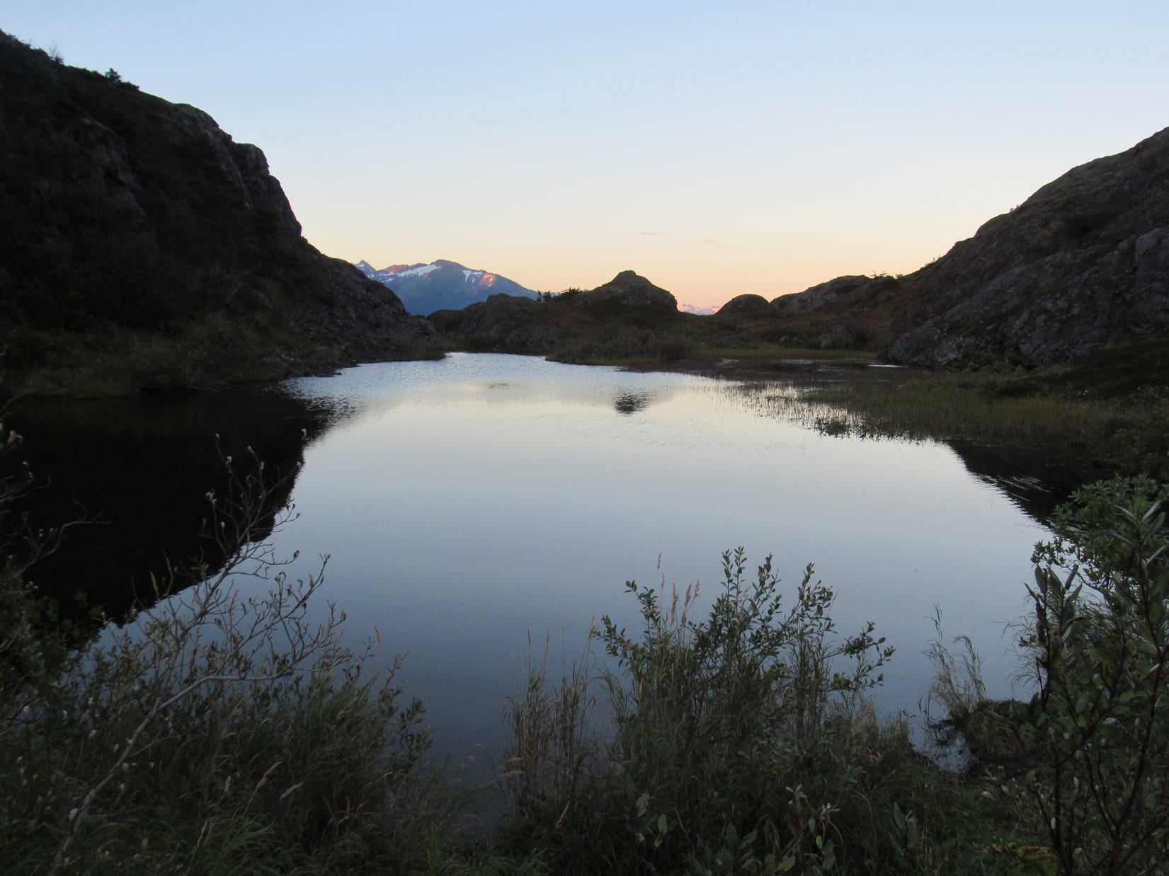
A maze of small trails climbed a variety of hilly rock formations and small ridges in Portage Pass. Lupe climbed up for a better look. A small pond known as Divide Lake was ahead to the SW. Divide Lake sat lower down on a broad, brushy flat area, beyond which Lupe saw Portage Glacier extending all the way down to the far shore of Portage Lake.
Lupe on a rocky high point in Portage Pass. She had a fabulous view of the Portage Glacier from here! Photo looks SW.Beyond the lower small pond known as Divide Lake, Portage Glacier could be seen flowing all the way down to the far shore of Portage Lake. Photo looks SW.Portage Glacier. Photo looks SW using the telephoto lens.The Portage Glacier still reaches Portage Lake, and still calves icebergs into it. The glacier will not have to retreat much farther, though, before icebergs in Portage Lake will be a thing of the past. Photo looks SW.Lupe was fortunate to see the Portage Glacier on such a clear day. Nearby Whittier has 196 inches of average annual precipitation, including 241 inches of snowfall. Yeah, might want to bring the raingear, just in case.The Portage Glacier was far from the only beautiful sight from Portage Pass. Here, Bard Peak(3,800 ft.) and part of the much smaller Shakespeare Glacier are in view on the L. Photo looks SSW.
A trail continues beyond Portage Pass all the way down to Portage Lake, which is another mile away. Unfortunately, Lupe had arrived too late in the day to go that far. However, while she was up at Portage Pass, Lupe met Matt and Elisa from Nome. They decided they wanted to go at least to Divide Lake, so Lupe and SPHP tagged along, too.
From Divide Lake, it wasn’t possible to see the lower part of the Portage Glacier where it reaches Portage Lake. However, Lupe did have beautiful double views of the upper portion of the glacier and surrounding peaks reflected in the lake
Lupe saw the upper portion of the Portage Glacier and surrounding peaks reflected in mirror smooth Divide Lake. Photo looks SW.
Lupe at Divide Lake. Photo looks SW.
Lupe, Matt, Elisa and SPHP went a little beyond Divide Lake, eventually reaching a bench. Bushes had grown up so much, anyone sitting on the bench no longer had a view of the Portage Glacier. SPHP could see it, but only by standing on top of a big rock nearby. Lupe saw only bushes in the direction of Portage Glacier, but she could still see big waterfalls on the mountains to the S.
From the bench beyond Divide Lake, Lupe could still see big waterfalls on the mountains to the S, although she had no view of the Portage Glacier. Photo looks S.SPHP could see the Portage Glacier only by standing on a big rock next to the bench. However, this was a slightly better view than Lupe had had back up at Portage Pass. More of Portage Lake and some of the icebergs in it could be seen. Photos looks SW.In late August 2016, Portage Glacier barely reached Portage Lake.The impressive waterfalls Lupe could see to the S made a distant, soothing roar.Through the telephoto lens.
Matt and Elisa talked about life in Nome. Elisa told of having to call in late for work sometimes due to herds of musk oxen blocking the road. Elisa was the first person Lupe or SPHP had ever met who had this problem. There can’t be too many places in the world where musk oxen in the way would be a well-received excuse for being late to work.
Byron Peak (4,700 ft.) and the Portage Glacier near sunset. Photo looks SW.A final close look at the Portage Glacier ice viewed through the telephoto lens.
Sunlight was rapidly disappearing. Soon it would be gone even from the mountaintops. Lupe, Matt, Elisa and SPHP all started back for Portage Pass. At the pass, Matt and Elisa went on, but Lupe tarried. From another rocky hill in the pass, Lupe had a beautiful view of Passage Canal back toward Whittier.
Looking across a small pond in Portage Pass in the opposite direction from the Portage Glacier. Photo looks NE.Lupe near a cairn on one of the small rocky hills in Portage Pass. She had a tremendous view of Passage Canal back toward Whittier! The top of Lowell Peak(L) is still sunlit for a few more moments. Photo looks NE.Lowell Peak(4,728 ft.) from Portage Pass. Photo looks NE using the telephoto lens.
A few late stragglers were still heading up the Portage Pass trail as Lupe headed back down to the G6. Before long, it would be too dark for them to see much of anything at Portage Pass. Most of the time, the trail was deserted. Lupe arrived back at the G6 (9:17 PM).
Even though it was getting dark, Lupe and SPHP drove into the town of Whittier, to see what it was like. Whittier was a strange place. There were few homes, and only a small run-down looking business district. Three high-rise buildings were perched up against the base of towering mountains, but only one of them was lit up.
On a Sunday evening, there wasn’t much going on, but it was easy to see that Whittier must ordinarily be a busy place. There were lots of commercial buildings around. Large parking lots were crammed full of vehicles and boats. Down by the shore, a great many boats were moored along illuminated docks in a cove of Passage Canal. Multiple railroad tracks ran through town.
The whole place had an abandoned industrial air to it, though what could be seen of the setting was spectacularly beautiful. Did Lupe want to spend the night stuck in Whittier? No, probably not. There was still time to make the 10:00 PM tunnel access back out of Whittier to the rest of the world.
So Lupe left spectacular Portage Pass, and the odd, beautifully situated town of Whittier behind. She made one more spooky trip trip through Anton Anderson Memorial Tunnel, emerging from the far end beneath a starlit Alaskan sky.
Passage Canal from Portage Pass near sunset. The strange little town of Whittier is out of sight along the cove to the R.
Start (9:50 AM, 61°F), intersection of 7-11 Road & Red Valley Road several miles SE of Wind Cave National Park.
Wow! A perfect spring day for bagging a couple more Black Hills peaks – blue skies, calm, almost room temperature. Even though April was barely underway, it might even get a little too warm in another couple of hours.
Lupe was excited. She’d already had a great time barking at cows and horses from the G6 all the way to Buffalo Gap. She’d seen one of her two peakbagging goals for the day, too. SPHP had let her out of the G6 for a couple of minutes for a quick look at Unkpapa Peak(4,280 ft.).
Unkpapa Peak from Red Valley Road (County Road No. 5). Photo looks S.
Before taking on Unkpapa Peak, Loop had other business to attend to. For the past several months, she had been working on climbing southern Black Hills peaks Brian Kalet had added to the Peakbagger.com data base last May. Now she was almost done. One more Brian Kalet peak remained – Peak4160. Lupe was going to get Peak 4160 over and done with first.
Crumbly and steep – a bad combination! The route SPHP choose to start off with was silly and unnecessary. The red dirt of the steep hillside was damp and messy. The white gypsum rock crumbled easily, providing unreliable support. Lupe didn’t have a problem negotiating the hillside, but it took SPHP a while to reach the more solid gypsum cap at the top of the hill.
Lupe had no problem climbing this steep, crumbly hillside, but it sure slowed SPHP down. This was a crazy route up Peak 4160, anyway. Lupe would soon have to lose nearly all the elevation she gained climbing this hill before even starting up the main ridge.
On the other side of the hill was a pine forest and easier terrain. Unfortunately, Lupe had to lose nearly all the elevation she had just gained. The ground sloped down into a series of ravines she had to go around or through.
Once she was past the last of the ravines, Lupe started a steady climb up the W face of Peak 4160. The forest thinned out rapidly. On the upper slope few trees were left to block the steadily improving views.
As Lupe climbed the W face of Peak 4160, the forest dwindled away rapidly. From the upper slopes she had a great view of Unkpapa Peak (L). 7-11 Road is seen below. Photo looks SSW.
Down in the forest Lupe hadn’t seen much cactus, but up on the sunny, barren, upper slope it was a different story. The higher Lupe went, the more cactus she found. By the time she reached the ridgeline, Lupe was not a happy Dingo. She begged SPHP to carry her, or at least scout out the route ahead.
With so much cactus on Peak 4160, Lupe insisted that SPHP scout ahead for danger before she would follow. Here she’s on her way having received the signal that this next part of the route was cactus-free. Photo looks SE.Good job, SPHP! No cactus at all on that last stretch. Take your time and keep up the good work. I’ll wait here until you give the signal. Make sure you don’t miss any! My paws are at stake!
Peak 4160 is a long ridge running almost straight N/S. The W face is quite steep, but the mountain slopes away only gradually to the E. Lupe had come up well S of the high point, which the topo map showed was somewhere quite close to the W edge. She headed N along the edge looking for the true summit.
Cactus was the only serious obstacle. With SPHP’s scouting help, and an occasional lift over the worst of the cacti, Lupe arrived at a line of small rocks of almost equal elevation. These rocks were the true summit of Peak4160. It was a great moment. Lupe had done it – she had climbed the last of her Brian Kalet peaks in the southern hills!
Lupe reaches the true summit of Peak 4160, the last of the Brian Kalet peaks she was going to climb in the southern Black Hills. She was pretty happy, thinking this was the last cactus-infested mountain she would have to climb. SPHP hadn’t sprung the news about Unkpapa Peak on her yet! Photo looks N.Lupe found this line of small rocks at the top of Peak 4160. They were 20 or 30 feet away from the W edge of the mountain. Photo looks S.
The topo map showed two separate areas on the mountain within 4,160 foot elevation contours. Brian Kalet had marked the southernmost of these areas as being the location of the true summit. Lupe had reached this S area first, and she could see the next high point to the N from here. It definitely looked a little lower.
Lupe was glad! She was already at the true summit and could skip the remaining cactus-infested trek to the N high point.
The rocks of the true summit were 20 or 30 feet from the edge of the steep W face of the mountain. Of course, the edge was where all the best views from Peak 4160 were. Naturally, Lupe went over to check them out.
The best views from Peak 4160 were along the W edge of the mountain. Although blue skies had prevailed when she started up, Lupe could now see clouds building to the NW. Photo looks NW.Unkpapa Peak (L) from Peak 4160. Photo looks SSW.Gravel 7-11 Road stretches away to the SW. Lupe had come up Peak 4160 through the forest seen below on the L. Photo looks SW.
Happy with the last of the Brian Kalet peaks already in the bag, Lupe returned to the true summit briefly before starting her trek back down the mountain.
Lupe returned to the true summit briefly before starting down. Photo looks E.
She began her return to the G6 heading S along the W edge where the views were best. Before leaving the ridgeline, Lupe stopped briefly at a couple of points along the way.
Looking W before leaving the ridgeline.Looking NNW.
Although it had been sunny and warm earlier, by the time Lupe was down the skies were gray. A cool wind was blowing. Off to the NW, it looked like rain. Lupe passed by an ancient windmill, the old blades still capable of spinning in the breeze.
By the time Lupe was down off Peak 4160, the weather had changed. The skies were gray, a cool breeze was blowing, and it looked like rain to the NW. She passed by this ancient windmill, its old blades still spinning in the wind. Photo looks SW.
At 1:15 PM, Lupe jumped into the G6 when SPHP opened the door. Was she ever surprised when SPHP politely informed her she wasn’t going anywhere until she climbed Unkpapa Peak, too!
Loopster was fine with that! Carolina Dogs are always ready for the next adventure. Lupe abandoned the G6, and started for Unkpapa Peak. Her journey began below a line of low cliffs near the edge of a dry creek bed.
Lupe passed by this line of colorful low cliffs to start her journey up Unkpapa Peak.
After crossing some easy open ground, the terrain became steeper as Lupe climbed up through a forest. Her route was steepest near the end of the climb where only scattered trees remained.
Lupe on her way up Unkpapa Peak. The steepest part of the climb is directly ahead, but wasn’t at all difficult. Photo looks SE.
Lupe reached the top of the Unkpapa ridge at its northernmost point. The weather had continued to deteriorate. Up here it was windy and cool. SPHP was putting layers back on, but Lupe had to make do with the same lovely brown and white fur outfit she wears in all kinds of weather.
Like Peak 4160, Unkpapa Peak features two different areas contained within equally high elevation contours. That meant two possible sites for the true summit. On Unkpapa Peak, these two areas are separated by more than a mile. The topo map showed a survey benchmark at the N high point, which wasn’t too far away from where Lupe reached the N rim of the mountain. The name Unkpapa Peak was also shown at this point on the map.
While Lupe headed ESE along the edge of the N face on her way to the closest summit, SPHP kept an eye out for the survey benchmark.
Looper stands in the cool wind along the N rim of Unkpapa Peak, a little E of where she first came up. American Dingoes are not fans of wind. Photo looks E.The N high point of Unkpapa Peak is visible on the L. Lupe didn’t have far to go to get there. The skies were still blue to the E, but Loop wouldn’t see the sun in all her time up here since clouds continued to move into the area. Photo looks ESE.Lupe still standing in the wind along the N rim. The weather looked increasingly stormy off to the NW (L). The intersection of 7-11 Road and Red Valley Road is seen below. A quarry is in view on the far side of 7-11 Road. Photo looks NNW.
Lupe hadn’t seen much cactus on the way up Unkpapa Peak, but when she reached the top of the ridge there was plenty of it around. SPHP’s scouting and Port-A-Puppy services were called into play again. Lupe still hates cactus, but with all the cactus-infested mountains she’d been climbing recently in the southern Black Hills, she was getting fairly used to dealing with it.
Lupe made good progress along the N rim toward the summit. SPHP was surprised when she found a survey benchmark a couple hundred yards before reaching the high point. The topo map only showed a benchmark at the top.
Lupe found this survey benchmark a good 200 yards W of the N summit.
The cactus was annoying, but could not stop Lupe from reaching the N summit. She arrived to find a couple of modest rocks at the very top. Lupe got on them to claim 1/2 of her peakbagging success on Unkpapa Peak(4,280 ft.). This summit was quite close to the N rim, but thankfully trees along the edge helped block the N wind.
Shortly before reaching the N summit, Lupe came to this great view of Buffalo Gap. Photo looks ENE.Almost there! A happy Carolina Dog awaits another cactus all clear signal from SPHP. She’s almost to the N summit of Unkpapa Peak. Photo looks WNW.Ta da! Looper stands atop the N summit of Unkpapa Peak. Photo looks E.
After reaching the N summit, Lupe looked around the area close by for both the best view of Peak 4160 from Unkpapa Peak and another survey benchmark. A break in the trees along the N rim provided a great look at Peak 4160, but there didn’t seem to be a second survey benchmark.
A break in the trees along the N rim provided a great look at Peak 4160 (the closest big ridge) from Unkpapa Peak. Photo looks NNE.Peak 4160 with some help from the telephoto lens. Photo looks NNE.
Lupe and SPHP took a break under a big pine tree a little back from the N edge where the wind wasn’t so strong. Lupe had eaten some Taste of the Wild up on Peak 4160, too, but she was still kind of hungry. She had another helping.
Even under this pine tree there was cactus. Hopefully, Unkpapa Peak was to be the last of the lower southern Black Hills peaks with cacti that Lupe would have to climb for a long time. She sure wouldn’t miss the cactus. Neither would SPHP.
One thing Lupe wouldn’t miss from these lower, drier southern Black Hills peaks was all the blasted cactus.
Yet it had to be admitted that despite the lower elevation of these southern peaks, the drier climate where cactus thrived and trees didn’t fare as well had provided Lupe many outstanding sweeping views unlike those found in the much more heavily forested Black Hills typical farther N.
After the short break beneath the pine tree, Lupe returned to the summit rocks, which were close by. On the way, SPHP noticed a second survey benchmark. So there was one here after all! It was a little S of the highest rocks.
As Lupe returned to the summit rocks after her break, SPHP noticed this second survey benchmark a little to the S of the highest rocks.Lupe back at the N summit after her break. Although the N and W faces of Unkpapa Peak are fairly steep, the top of the mountain is a gently undulating plain. The S summit, more than a mile to the SW is in view on the L. The trees on the R are all near the edge of the W face. Photo looks SW.
The N and W faces of Unkpapa Peak are fairly steep, but the top of the mountain is a gently undulating plain. Looking SW across this plain from the N summit, it was possible to see several high points more than a mile away, but it was hard to tell which might be the S summit.
To really claim a completely valid peakbagging success on Unkpapa Mountain, Lupe would need to visit the S summit as well. If the topo map was correct, odds were that the S summit was also technically the true summit, since the area enclosed by the 4,280 foot contour was much larger over there.
Lupe headed SW across the undulating plain. Cactus was a constant threat, but wasn’t nearly as thick as it had been along the N rim. Lupe and SPHP enjoyed the easy stroll. The wind wasn’t nearly as bad here as along the N rim. The air was comfortably cool. Meadowlarks were singing.
Lupe discovered a huge bone.
Looper found this huge bone shortly after starting on her way to the S summit. Too bad it had long been completely picked over. What a prize it would have been fresh!
Unfortunately, the huge bone had been completely picked over long, long ago. By all appearances, it had been laying here bleaching in the sun for years. What a glittering Dingo prize it would have been when fresh! Lupe was way too late for that.
The next thing Lupe found was of much more practical use. She came to a trail! The trail meant an almost guaranteed cactus-free path. Lupe was enthused. She took the lead, running back and forth ahead of SPHP. She was making rapid progress now.
After finding the trail, Lupe made rapid progress. Although SPHP wasn’t certain of it yet, the barren ridge seen slightly R of Center behind her proved to be the S summit of Unkpapa Peak. Photo looks SSW.Looking NE back at the N summit of Unkpapa Peak from a small, rock-covered hill. The trail Lupe had been following is in view on the hillside.
Suddenly there was movement ahead! A small herd of deer had become aware of the approach of a ferocious American Dingo. They quickly bounded out of sight over the W rim of the mountain. Lupe raced over there. From the edge, she was disappointed to find the deer had vanished, but she did get a good look at the stormier conditions prevailing over the higher Black Hills to the NW.
A small herd of deer bounds away before disappearing over the W edge of Unkpapa Peak. Photo looks SW using the telephoto lens.From the W rim of the mountain, Lupe caught no sight of the deer, but did see the stormier weather prevailing over higher hills to the NW. She would rather have seen the deer.
It wasn’t much farther now to a rocky ridge that might be the S summit of Unkpapa Peak. Lupe stayed neared the trees along the W rim of the mountain as she traveled S toward the ridge. A disturbing amount of cactus was present whenever she ventured away from the trees. SPHP had to help her past it in a few places.
The ridge itself was barren, but didn’t have as much cactus. Upon reaching the top, it became clear this ridge was indeed the S summit. Lupe had made it! A 75 foot long line of modest to good-sized rocks and boulders of similar elevation formed the highest part of the ridge. Lupe got up on several of the highest rocks for a look around.
Lupe reaches the rocky ridgeline at the S summit. Photo looks SW.Looking W.Looking NE back at the N summit. The N summit appears to be considerably higher in this photo, which is deceptive. While actually there, both the N and S summits did seem to be about the same elevation.From a distance, it had been hard to tell if this ridge was actually the S summit or not. However, this view from the top looking WSW over the next canyon left no doubt.
The most dramatic views were off to the W and N, but Lupe could see in every direction from the barren S summit.
Pines line the edge of the W rim of the mountain. Lupe could see far beyond them. Photo looks N.Lupe had a big view to the NW, but rain showers hid the higher, more distant hills.
Reaching the S summit meant that Lupe’s peakbagging tasks were complete on Unkpapa Peak. Whether the N high point or the S high point was the true summit didn’t really matter now. Lupe had been to both.
For 20 minutes or so, Lupe and SPHP remained up on the S summit. Looper had plenty of time to get back to the G6, but there was no rush. It was too late in the day for another adventure.
The wind blew, but not as strongly as it had earlier along the N rim. The sky tried to spit rain, but didn’t achieve much in the way of results. The air was cool, but not cold. Lupe and SPHP stayed together on the rocks, enjoying the panorama from Unkpapa.
Even though she wasn’t that far from home, it might be a long time before Lupe returned for another expedition this far S in the Black Hills. The Brian Kalet peaks Lupe intended to climb were finally complete. Except for the cactus, the last few months climbing them had been surprisingly fun.
An American Dingo lingers atop the S summit of Unkpapa Peak. Photo looks ESE.
On the way back N, Lupe took the scenic route staying near the W rim for the huge view. The farther N she went, the more cactus there seemed to be, but SPHP helped the Carolina Dog through it.
Looking back at Unkpapa’s S summit. Photo looks SE.The grand view from the NW rim of Unkpapa. Photo looks N.
Lupe went back down the N face about where she’d come up. A colorful hill to the NW caught SPHP’s fancy.
This colorful small hill caught SPHP’s fancy on Lupe’s way down. Photo looks NW.
It was still early when Lupe reached the G6 (5:11 PM, 47°F). She had plenty of daylight for enormously satisfying frenzied barking at the numerous cows and horses she saw on the drive home.
For the 3rd expedition in a row, Lupe celebrated the end of the day with a chocolate milkshake from the Sonic Drive-In. The milkshake was fancied up with whipped cream and a cherry on top.
American Dingoes love whipped cream! The cherry? It was graciously ceded to SPHP.