Day 1 of Lupe’s 2017 Dingo Vacation to the Laramie Range, Wyoming & Beyond
Nine months gone. Practically an eternity! Late in the evening, Lupe laid sad-faced and bored on the even sadder-looking old couch clawed up by 4 cats who no longer lived here. Did she ever even think anymore about those glorious days of her last and greatest 2016 Dingo Vacation when she’d gone all the way to the Canadian Rockies, Yukon & Alaska?
If so, you couldn’t tell it. Of course, maybe she was thinking of those times, and how long ago and far away it all seemed was what was making her sad. Loopster heaved a sigh, staring vacantly over the edge of the couch. She looked like she had lost her last friend.
Forlorn Lupe.
She hadn’t, of course. She’d been on lots of Black Hills expeditions full of adventures with SPHP over the last nine months. Fun times, but not the same as hitting the open road for days on end spent exploring exciting, beautiful, distant lands.
While Loop moped on the couch, SPHP was not idle. A warm, fragrant breeze stirred the air. Late spring by the calendar. Early summer by SPHP’s reckoning.
Better enjoy lounging around like that while you still can!
Lupe’s eyes shifted to watch SPHP busily checking equipment and supplies. Her expression didn’t change.
You’ll see, soon enough!
Promises, promises. Nothing fun happened. Dullsville.
The next morning SPHP was up early. Shower, breakfast, and then back and forth packing all this stuff into the G6. Lupe began to realize something really was up. A glimmer of hope in her eyes grew rapidly to increasing anticipation.
Mountain climbing season, Loopster! It’s here! You ready?
Was she ever! Only a few hours later, Lupe was in Wyoming, whizzing along in the G6 headed for her first adventure of her first Dingo Vacation of 2017. Had the mood ever changed from last night! Looper was ready to let the good times roll!
Lupe returns to the great state of Wyoming at the start of her first Dingo Vacation of 2017. Oh yeah, this is gonna be good!
Lupe was headed for the Laramie Mountains in SE Wyoming. Only 8 days into June, it was still weeks early to head up into some of the higher Wyoming ranges for mountain climbing, since there would still be too much snow on the peaks. However, with the exception of Laramie Peak(10,272 ft.), the highest mountains of the Laramie Range top out only a little over 9,000 ft. There might still be some snow around in early June, but not enough to be a problem.
By early afternoon, Lupe reached Douglas, Wyoming. SPHP drove S from there on Hwy 94. The highway eventually turned to gravel and became County Road No. 5. A mile N of Esterbrook, SPHP had planned to let Lupe tag Prairie Dog Hill(6,400 ft.) as her first peak “climbed” in the Laramie Range this year. It wasn’t even really a climb at all, since County Road No. 5 goes almost right over the high point. Pathetically easy.
However, when Lupe arrived at Prairie Dog Hill, a cattle drive was in progress right on the road. Lupe was almost out of her mind with delight! She bounded from window to window of the G6 in a foaming-at-the-mouth barking frenzy. She was eager to get out and help drive some cattle herself! Not such a good idea. The cowboys might have an issue with that. SPHP drove on, turning E at Esterbrook on USFS Road No. 633.
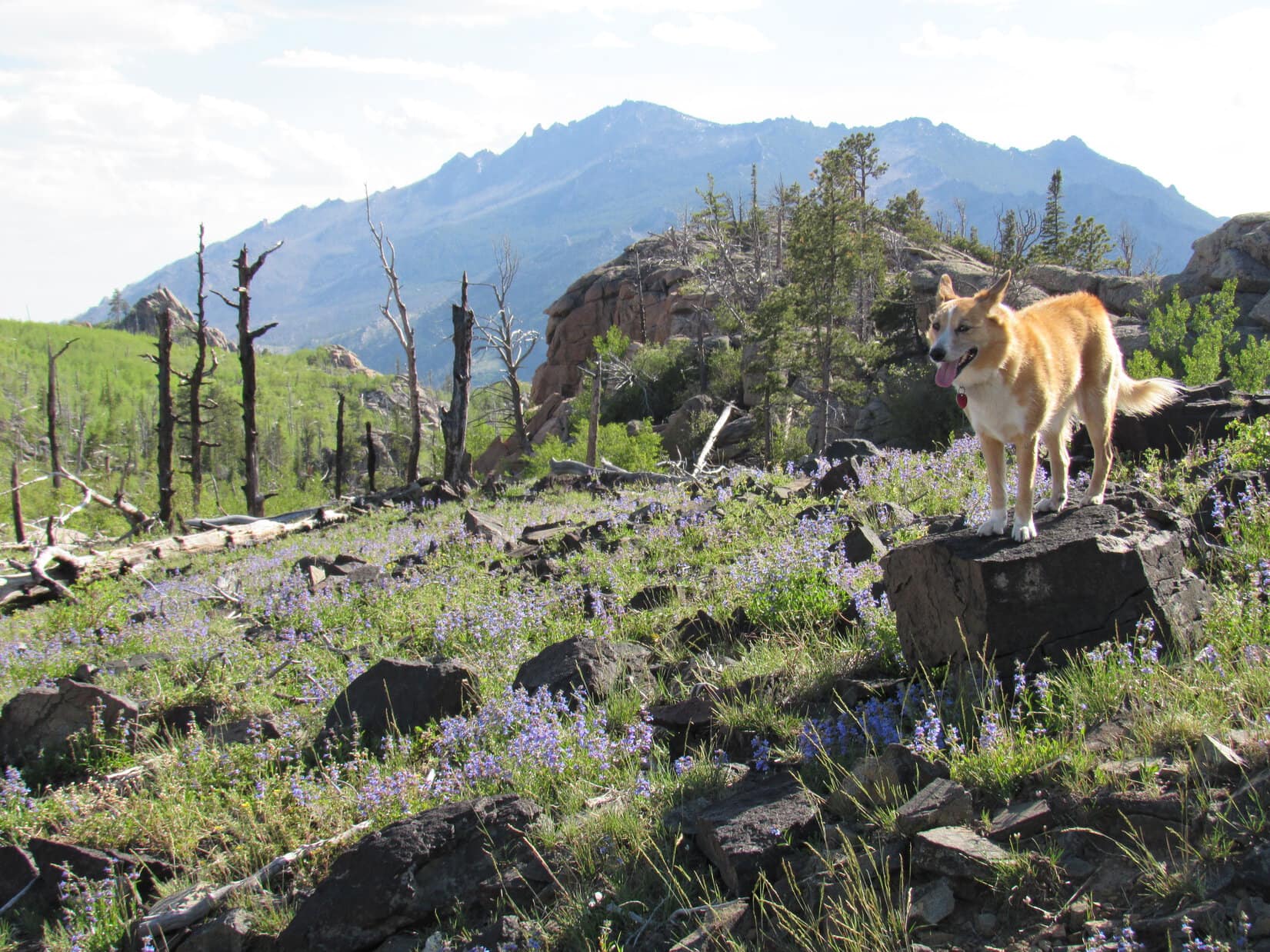
No. 633 wound N & E for several miles. Shortly after passing Esterbrook Campground, the road began to lose elevation and turned S. Lupe’s first real peakbagging objective, Black Mountain(7,960 ft.), came into view.
Black Mountain (L) comes into view from USFS Road No. 633. Laramie Peak, the highest mountain of the Laramie Range is seen in the distance on the R. Photo looks SSW.Black Mountain (Center) was Lupe’s first real peakbagging goal of her 2017 Dingo Vacation to the Laramie Range & Beyond. Photo looks SSW.
Black Mountain was still 9 or 10 miles SSW from where it first came into view. On the way there, Lupe stopped by Horseshoe Creek, which flowed right along USFS Road No. 633 for a couple of miles.
Lupe stops by scenic Horseshoe Creek on the way to Black Mountain. She would later spend the night at the pullout off USFS Road No. 633 seen beyond her.
Looking for USFS Road No. 667, SPHP turned off No. 633 at Camp Laramie Peak, a Boy Scout camp at Harris Park. Lupe and SPHP made inquiry at the main office on how to find No. 667 to Black Mountain.
Lupe stopped at Camp Laramie Peak to inquire about how to find USFS Road No. 667 to Black Mountain. She was a good deal more enthusiastic about how this day was going than the boy outside the Boy Scout camp’s main office.
Camp Laramie Peak was just opening up for the summer season. Councilors were already here, but the first Boy Scouts were just beginning to arrive. Fortunately, an official was available who told SPHP that USFS Road No. 667 (unmarked) to Laramie Peak went right through the camp. He pointed out a road that went S down a little hill.
The road would quickly deteriorate to a high-clearance proposition – it wasn’t going to be G6 friendly at all. This was known in advance from the topo map where No. 667 was marked 4WD. The intention all along had been to ditch the G6 somewhere, and follow the road on paw and foot. Fortunately, SPHP was free to park the G6 at Camp Laramie Peak at a small parking area near the main office.
It turned out that USFS Road No. 667 (a 4WD road) to Black Mountain goes right through Camp Laramie Peak. The officials at the camp said SPHP was free to park the G6 at a small lot not far from the main office, so Lupe’s trek up Black Mountain started right here.
At 3:08 PM (79°F), Lupe and SPHP set off. There had been one caveat mentioned at the office about taking USFS Road No. 667. The road went through Boy Scout property for the first half mile or so. Leaving the road was not permitted. No trespassing on Boy Scout land! Seemed like an odd demand from an organization dedicated in part to promoting the outdoors, but another official reiterated this rule as Lupe and SPHP ambled along the road through the camp.
Whatever, no problem. SPHP adhered rigidly to this restriction. The American Dingo, having spent most of the day cooped up in the G6, was somewhat less diligent. Lupe had a fun time roaming and exploring the forest not too far from the road.
After dipping down through camp, No. 667 crossed a small stream and then began to wind W climbing steadily. Bluebells were growing in profusion in the forests and fields. It was a pretty day, a bit warm, and Lupe was off to a good start. She was beyond forbidden Boy Scout territory in a jiffy. A mile from camp, she arrived at a minor saddle near large rock formations.
Loopster among the bluebells.
About a mile from Camp Laramie Peak, Lupe reached these large rock formations at a minor saddle. Photo looks NNE.
Still hidden from view more than a mile N of the minor saddle was Peak7320, another mountain SPHP hoped Lupe would get a chance to climb. First things first, though! The road turned due S from the saddle and climbed more steeply than before. Lupe followed it, continuing toward Black Mountain.
No. 667 soon turned SW and leveled out for a little way. Peak 7320 now came into view back to the N. The mountain was capped by a huge knob of solid rock. Lupe might not be able to get to the top, even if there was time enough later on for an attempt.
Peak7320 from USFS Road No. 667 on the way to Black Mountain. Photo looks N.
Off to the SW, the summit of Black Mountain had come into view, too. It was a little hard to recognize at first, but got easier to discern as Lupe continued along the road. A fire lookout tower was perched way up on the highest rocks.
The summit of Black Mountain (far L) came into view here, but it was still so far off, it was hard to recognize at first. Photo looks SW.Getting closer! The fire lookout tower on the summit (Center) is now discernable. Photo looks SW.The fire lookout tower at the summit (R of Center) with help from the telephoto lens. Photo looks SW.
No. 667 soon began to climb again fairly steeply. Before long, it made one big jog to the NW before turning sharply S. Once it made the turn, the road started leveling out. Lupe was still gaining elevation, but at an easy pace. The Carolina Dog now enjoyed a pleasant journey S to the summit along the big N ridge.
The views were increasingly beautiful! Albany Peak(7720 ft.) could be seen to the SSE. A little farther on, Laramie Peak(10,272 ft.) came into view to the SW.
Albany Peak is seen straight up from Lupe on the L. Photo looks SE.Laramie Peak, the highest mountain of the entire Laramie Range, comes into view. Photo looks SW.Lupe traveling the big N ridge. The summit is in view, still a little way off. Photo looks S.
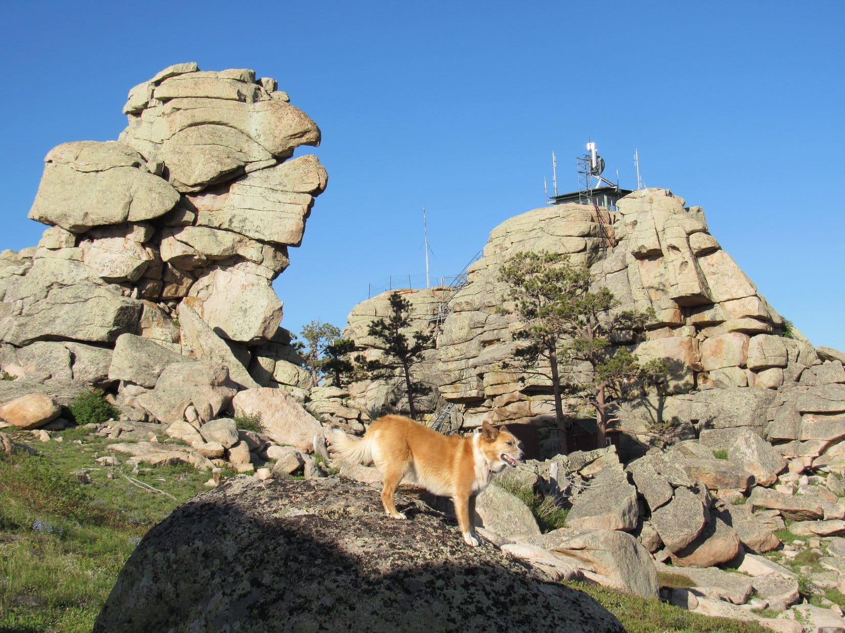
Lupe continued S along No. 667 until it curled around a big rock formation, and suddenly ended at the base of the massive stone knob the fire lookout station was perched on. A steep metal stairway was the only way up.
Lupe arrives at the end of USFS Road No. 667. She did not like the steep stairway leading to the fire lookout station. Photo looks ESE.
The American Dingo didn’t like the look of those stairs! She stayed at the bottom, while SPHP climbed the first longest section. SPHP had to plead with her to follow. She finally did come up, but not until SPHP was about ready to go down and get her.
A metal platform turned 90°, and led in a few feet to a 2nd shorter flight of stairs. SPHP climbed this 2nd set, only to turn around and see Lupe running back down the 1st flight all the way to the bottom again. SPHP returned to the top of the 1st flight to resume pleading and coaxing. Looper finally relented. This time she made it all the way to the fire lookout station to claim her peakbagging success!
Despite the long, scary metal stairway, Lupe makes it to the fire lookout station on Black Mountain(7,960 ft.) to claim her peakbagging success! Photo looks S.
The day had been warm and the air calm all the way up the mountain. Even down at the base of the metal stairway, there hadn’t been much of a breeze. However, up at the fire lookout tower, it was considerably cooler. An annoyingly strong gusty wind was blowing out of the SSE. The last bit of elevation gain had made a surprising difference!
It was so windy, Loopster wanted to take shelter in the lookout tower. She was most disappointed that it was padlocked shut, and no one was around to let her in. The views were splendid in every direction. Somewhat reluctantly, the Carolina Dog cooperated with taking photos. She preferred to spend her time on the N side of the tower out of the wind.
Lupe and SPHP made several forays around the tower to check out the views, returning frequently to the N side for breaks from the wind.
Of course, the most impressive view from Black Mountain was toward Laramie Peak(10,272 ft.), the highest mountain in the entire Laramie Range. Photo looks SW with help from the telephoto lens.Looper checks out the view of Laramie Peak. Photo looks SSW.The view to the N.Another look to the N.Albany Peak(7,720 ft.) (L) from Black Mountain. County Road No. 71 down in the Cottonwood Creek valley is seen in the foreground. Photo looks SSE.Another look at Albany Peak a little later on with help from the telephoto lens. Photo looks SE.Haystack Peaks are seen in the foreground on the R. Beyond them in the distance is Bear Head Mountain (8,359 ft.). Photo looks SSW.Another look SSW, this time with more help from the telephoto lens. Haystack Peaks are in the foreground. Bear Head Mountain in the distance.Laramie Peak (R) dominates Haystack Peaks (L foreground) and Bear Head Mountain (L distant). Photo looks SW.The view to the NW. USFS Road No. 667 is seen below.
Lupe spent a good 30 minutes up at the summit of Black Mountain(7,960 ft.). Before leaving, the Carolina Dog and SPHP took a longer break out of the wind on the N side of the lookout tower. Lupe had water and Taste of the Wild. Then it was time for one last look at Laramie Peak from the top, and a final stroll around the lookout tower.
A last look at Laramie Peak from the Black Mountain fire lookout tower. Photo looks SW.After half an hour up at the windy fire lookout tower on Black Mountain, Lupe waits on the sheltered N side of it for the signal from SPHP that it’s OK to start down and get out of the wind once and for all. Photo looks S.
In her eagerness to get out of the wind, Lupe showed no fear of the long metal stairway leading down to USFS Road No. 667. She raced to the bottom in nothing flat. It was still a little breezy back down at the road, but nothing compared to the gusty wind up at the tower.
SW of the lookout tower were some great viewpoints where Laramie Peak was on display. Lupe took a little time to sniff around and explore this area.
Laramie Peak from SW of the lookout tower. Photo looks SW.Looking NE back up at the fire lookout tower.
When Lupe was satisfied with her explorations of the summit area, she headed back N along USFS Road No. 667. She would retrace her route up following the road all the way back to Camp Laramie Peak.
Bluebells on the way back.
Although SPHP had hoped Lupe would have time to take a crack at Peak 7320 on the way down, the sun was starting to get low. Since it looked like there wouldn’t be sufficient daylight to summit and get back to the road before dark, Lupe never made the attempt.
Peak 7320 (Center) seen a little before sunset on the way down Black Mountain. Unfortunately, Lupe wouldn’t have enough daylight to climb it and find her way back to the road before dark. Photo looks N.
It was 9:11 PM (52 °F) when Lupe reached Camp Laramie Peak again. In fading light, she was treated to a ride S in the G6 down the Cottonwood Creek valley on County Road No. 71. SPHP wanted to check out potential access routes to Albany Peak. Maybe Lupe could climb it tomorrow?
There proved to be numerous homes on private property along County Road No. 71. “No Trespassing” signs were posted all over the place. SPHP found one possible access point, but it wasn’t clear if this route went across private property or not. From Black Mountain, Lupe had seen a very large rock formation at the top of Albany Peak. Maybe she couldn’t even get to the top of the mountain, even if there was access?
Reluctantly, SPHP decided Lupe should skip Albany Peak, at least on this trip. SPHP drove N again, as Lupe barked enthusiastically at antelope grazing in the fields at dusk. It was dark by the time Lupe stopped at a pullout along USFS Road No. 633 near Horseshoe Creek for the night.
Sunset in the Laramie Range of Wyoming.
Only 24 hours ago, Lupe had been bored and despondent on the tattered old couch back home. Yet today she’d had a blast traveling to Wyoming and climbing Black Mountain. The lucky American Dingo’s summer of 2017 adventures had only just begun!
There’s nothing so rare as a day in June, and June had just arrived! Both Lupe and SPHP were raring to go, even though scattered thunderstorms were in the afternoon forecast. The plan was to head way out into the high country of the NW Black Hills for some peakbagging fun. First up were Peak 6888 and the Bald Hills(6,690 ft.), both within a few miles of the Wyoming border.
Although there were already clouds around, the sun was still shining when SPHP parked the G6 more than 0.5 mile W of County Road No. 117 along USFS Road No. 109 (Parmlee Canyon Road) at 9:39 AM (59°F). Lupe and SPHP started out taking Bear Canyon Road S from No. 109. Bear Canyon Road was just a dirt road that looked like it seldom gets any traffic. It passed through a field in a shallow valley and then entered the forest, winding its way up a low ridge at a pretty decent clip.
The climb was a short one. Bear Canyon Road soon leveled out, and reached a clearing where there was an intersection with more faint roads. Several whitetail deer ran off into the forest as Lupe approached the intersection. Peak 6888 is about 0.75 mile S of Parmlee Canyon Road. SPHP figured Lupe still had to go a bit farther S to get there. The road continuing S was marked as USFS Road No. 117.5J.
Lupe followed No. 117.5J up a couple of little rises. The road leveled out again after each one. When the road seemed to be at its highest point, SPHP stopped to check the topo map. The summit of Peak 6888 was supposed to be a little W of the road. The entire area looked quite level, although the forest did look a bit higher off to the NW. Lupe and SPHP left the road exploring the forest to the NW, while searching for an obvious high point or marker.
Lupe found neither. A big area was almost as flat as a pancake. Nothing seemed discernably higher or lower than anywhere else. Lupe saw more deer, but summits were scarce. Well, Loop, looks like this is all the summit! SPHP encouraged Lupe to hop up onto a big log. This can be your summit photo, Lupe! Might as well call it good, and go on to the Bald Hills.
Lupe seemed happy enough to call this log the summit of Peak 6888. There were no views in any direction, just more flat forest extending all around.
Peak 6888 was now in Lupe’s bag, but it hadn’t been too exciting. At least there was a little excitement when Lupe and SPHP returned to No. 117.5J. Lupe saw a female elk crossing the road. The elk saw Lupe and SPHP, too. It took off running, but seemed confused on which way it wanted to go. It finally disappeared off to the SE.
Lupe and SPHP continued S on No. 117.5J. Almost right away, Lupe came to a big square mud puddle where the road started angling SW. Lupe ran over to wade around and get a big drink of mineral water.
Lupe discovers the mineral water puddle on Peak 6888.The mineral water puddle looked like it could have been milk chocolate flavored.
From the milk chocolate colored mineral water puddle, No. 117.5J started losing elevation slowly, but steadily, as it went SW for about 0.75 mile. The road appeared to end in a small valley near a couple of stock ponds. There were several barbed wire fences in the area. Lupe and SPHP headed S across the little valley, and climbed up the next low ridge ahead. Up on top, Lupe found USFS Road No. 113 at a green gate.
By now the sky was completely overcast, and it began to rain steadily. SPHP wore a blue plastic rain poncho, but Lupe was doomed to become a progressively more soggy doggie. Lupe and SPHP marched W on No. 113 in the mud and rain. The clouds grew darker. The downpour strengthened, and the woods filled with fog.
Although Lupe ordinarily loves to get wet playing with the garden hose on warm, sunny days, the dreary downpour seemed to dampen her spirits. For 2 miles, Lupe and SPHP slogged W on No. 113. SPHP began to wonder what ever happened to the “scattered” part of the scattered T-storms in the forecast. It looked like it could rain buckets all day.
After going 2 miles, Lupe started passing by minor side roads that SPHP was expecting to see, and No. 113 gradually turned S. The road had been fairly level most of the time, but now began to lose some elevation. That didn’t last long. It was soon gaining the elevation back. Lupe reached a high spot on the road as it turned W. The road continued W, but it was clear it was about to lose serious elevation in that direction.
About this time, the rain stopped. Suddenly the sky was getting brighter again. SPHP stopped to check the maps. The little green hill on the N side of the road had to be the summit of Bald Hills. Lupe was practically there!
The remains of a campfire were on the N side of the road, too. Unfortunately, trash was scattered all around it. While SPHP collected trash, Lupe sniffed around, encouraged by the rapidly clearing sky.
Lupe just S of the summit of Bald Hills. The top was just up this little green hill. Photo looks N.A rather damp Lupe among pretty yellow flowers S of the summit of Bald Hills.
When the trash was all gathered up, Lupe and SPHP climbed the little green hill to the summit. The summit area was a bit surprising. It was a big flat open field, completely surrounded by pine trees.
Trees killed by pine bark beetles were still standing along the W edge of the meadow. When they eventually fall over, the view will improve dramatically. As it was, Lupe and SPHP could only get glimpses of Mount Pisgah(6,380 ft.) five miles away in Wyoming.
Lupe in the big flat meadow at the summit of Bald Hills. Photo looks W. The sky is beginning to clear!Looking W.Lupe starting to dry out in the sunshine. Photo looks NE.
The meadow on Bald Hills was quite pretty and full of little flowers. It was kind of a shame there wasn’t a more open view anywhere, but that’s the way it was. As Lupe and SPHP ambled around the field, the last of the storm clouds drifted away to the E, and the sun began to shine.
Lupe and SPHP left the summit taking what was supposed to be a shortcut back to No. 113 by heading directly E. There proved to be a fair amount of deadfall timber to deal with in the forest. While Lupe might have saved some distance, it was debatable how much time was really saved.
Once on No. 113 again, Lupe and SPHP followed it back E. Where dark clouds, rain and fog had prevailed only a short time ago, now a sunny, fresh, bright green Dingo Paradise existed. Lupe’s spirits soared! She dashed through the damp woods sniffing excitedly at every tree and bush. Lupe came to a series of small pools scooped out along the road. She made frequent use of them.
One of several pools of rainwater along USFS Road No. 113. The day was warming up rapidly. Lupe made frequent quick stops at the pools for refreshing drinks.
When Lupe reached the green gate across No. 113 again, she turned N leaving the road. Lupe and SPHP went down off the ridge into the small valley, this time passing above (E of) the higher pond. Lupe returned to No. 117.5J. Soon Lupe and SPHP were back up on Peak 6888 again.
Lupe took a Taste of the Wild break while resting under a fallen tree trunk. SPHP sat on the tree trunk eating an apple and looking at the maps. After the break, Lupe and SPHP once again wandered around on Peak 6888, still looking for an obvious high point, but with the same negative results. Lupe chose a bright green meadow for her 2nd Peak 6888 summit shot of the day.
Lupe near the upper pond on her way back to Peak 6888. This area is a little W of the Beaver Creek Cow Camp on the USFS map.Lupe takes a Taste of the Wild break while resting under a fallen tree on Peak 6888.Lupe chose this bright green meadow to commemorate her 2nd ascent of Peak 6888 of the day. Photo looks WSW.
SPHP had noticed while looking at the maps that 0.33 mile to the NE of Peak 6888 there was a small area enclosed by a 6,900 foot contour line. Since that was somewhat higher ground, Lupe and SPHP crossed over No. 117.5J to go check it out.
NE of No. 117.5J, Lupe did seem to gain a little elevation, but it didn’t amount to much. Lupe still found no obvious high point. There weren’t any big views anywhere over here either, just more forest. Lupe and SPHP went W back to Bear Canyon Road and turned N. By 1:48 PM (65°F), Lupe was back at the G6.
Lupe’s next two peakbagging goals were both located 10 miles to the NNW. Lupe and SPHP jumped in the G6, and enjoyed a very scenic drive through gorgeous Black Hills high country near the Wyoming border. The last part of the drive was along another USFS Road No. 109. (Not the No. 109 that leads to Parmlee Canyon.) This No. 109 led N out of the Beaver Creek valley. It eventually turned NW toward the Wyoming border.
SPHP was really hoping there would be some kind of a sign and a fence at the border. Lupe’s third peakbagging goal of the day was the Weston County, Wyoming High Point(6,620 ft.). The high point is located about 0.375 mile S of where No. 109 reaches the Wyoming border. The whole key to finding the Weston County High Point was knowing where the border was.
The luck of the Dingo prevailed! There was a Wyoming sign at the border. There was also a cattle guard, a fence, and a convenient level place to park on the South Dakota side (2:28 PM, 57°F). Lupe and SPHP left the G6, crossed the cattle guard into Wyoming, and headed S along the border fence.
The entire area was forested and rolling, but without significant elevation changes. Logging trails ran this way and that through the woods. When it seemed easier, Lupe and SPHP just followed the logging trails, but never got very far from the border fence. Pretty soon, Lupe came to two high points right along the state line. One of them had to be the Weston County High Point.
The two high points were close enough to each other so it was possible to see both at the same time. However, they were so similar in elevation, SPHP wasn’t certain which was truly the highest point. The first one Lupe came to, the one to the N, seemed like it was highest, but it was hard to tell for sure. Naturally, Lupe visited both high points.
Lupe at the N candidate for the Weston County, WY high point. She is sitting just past the border fence on the South Dakota side of the border. SPHP believes this is the true high point, but there was another possible candidate in view a short distance to the S. Photo looks E.
From the N high point, a small, nearly level ridge extended W about 100 feet into Wyoming. It was possible the Weston County High Point was actually somewhere along this ridge instead of right on the border with South Dakota. Lupe explored the W ridge out to where it ended at 10 foot high limestone outcroppings. SPHP was of the opinion the actual high point was back at the WY/SD border, rather than anywhere along the ridge.
Lupe seemed to enjoy looking for the Weston County High Point. Here she is looking happy while exploring the small ridge W of the border and the N high point candidate.Although Lupe explored this entire ridge W of the N candidate on the WY/SD border for Weston County, WY High Point, SPHP didn’t believe the actual high point was anywhere out on this ridge. To SPHP, the land seemed marginally higher right at the border. Lupe never did really come out and say what she thought.The W end of the ridge ended at these 10 foot high limestone outcroppings. Photo looks SE.
After exploring the W ridge, Lupe and SPHP went over to the S high point candidate along the Wyoming/South Dakota border. A small area on the Wyoming side near the S high point had been clear cut. There were slash piles laying all around. The S high point was a limestone outcropping right at the border. There wasn’t any ridge extending out to the W here. The ground went downhill immediately W of the high point.
Lupe at the S candidate along the WY/SD border for Weston County, WY High Point. Photo looks S.
Wherever the actual Weston County High Point truly was, Lupe had now been there, having explored both possible candidates, plus the W ridge. The forest blocked any views, so there was no reason to linger. A short distance up a little hill to the E just inside the South Dakota border was Lupe’s fourth peakbagging goal of the day, Peak 6645.
Why Peak 6645 is on Peakbagger.com’s official list of Black Hills 6500-foot Peaks is completely beyond SPHP. There are numerous other higher points close at hand that are not on the official list. A little over 0.1 mile to the NE is High Point 6651, a mile to the SE is High Point 6807, and a little farther E is High Point 6906. The topo map shows many other examples of higher points close at hand, too. Nevertheless, Peak 6645 is on the official list and the others aren’t.
Since Peak 6645 was on the official Black Hills 6500-foot Peaks list, Lupe was going to visit it. At least it had the great virtue of being located very conveniently close to the Weston County, WY High Point. Lupe and SPHP made the short trek up the hill. Between the trees was a hint of a view off to the WSW, but that was all. Nevertheless, Lupe seemed completely happy with Peak 6645.
One cheerful Carolina Dog on Peak 6645! Photo looks WSW at a little meadow. Lupe is about 30 feet W of the actual highest point on the hill, but it was only 4 or 5 feet higher than where she is here.
Lupe on the very highest part of Peak 6645. Photo looks NE.
The actual summit of Peak 6645 was an otherwise unremarkable 5 foot high mound in the woods. Lupe sniffed around for a couple of minutes, but even she didn’t find anything particularly fascinating. While Lupe was sniffing around, clouds were moving in again. Thunder started rumbling off to the NW. Lupe and SPHP hurried NE on to High Point 6651.
From High Point 6651, Lupe was able to see USFS Road No. 109 just below to the NE. Instead of going right on down to the road, though, Lupe and SPHP turned NW, following the ridge. The ridge soon played out, and sloped on down to No. 109 closer to the G6. A quick 0.25 mile road trek, and Lupe was back at the G6 (3:17 PM, 57°F).
Hwy 85 near Buckhorn was only a couple of miles NW on USFS Road No. 809 (the road number changes from No. 109 at the Wyoming border), but it was already raining again by the time Lupe reached the highway. Another thunderstorm was passing through. SPHP stopped in at the Buckhorn Bar & Grill to grab a hamburger. Lupe stayed in the G6, entertained by barking at black cows across the road.
Lupe sniffs around outside the Buckhorn, WY Bar & Grill.
The owner and the cook/waitress were the only people in the Buckhorn Bar & Grill. They were both friendly, and after a reasonable delay produced a pathetic-looking over-priced hamburger, which didn’t even come with fries or chips. SPHP took the sad little thing out to the G6 to share it with Lupe while waiting for the rain to stop. Lupe’s opinion of the hamburger was far different from SPHP’s. She greeted it with enormous enthusiasm, and would have eagerly consumed far more than her fair share, if SPHP had permitted.
The hamburger was gone in a flash. Lupe retired to the back seat of the G6 for a nap, while the rain continued outside. SPHP munched an apple and looked at the maps. Lupe’s 5th and final peakbagging goal for the day was Laird Peak(6,906 ft.), which was only 6 or 7 miles to the NE, and less than a mile from Hwy 85. Climbing Laird Peak wouldn’t take long. Gradually a new plan came to mind. Lupe could go on into Wyoming to Inyan Kara(6,360 ft.), a more isolated and interesting peak!
However, the rain went on and on. Thunder rumbled repeatedly from very dark clouds overhead. Lupe snoozed contentedly full of hamburger. The windows of the G6 fogged up. SPHP finally decided that if the storm didn’t end by 6 PM, Lupe would have to forget about Inyan Kara.
At 5:30 PM, a tiny white spot appeared in the clouds to the NW. For a few minutes, the white spot grew. A little patch of blue appeared. Maybe the storm was about over? SPHP started the G6 and drove SW on Highway 85. Within a few miles, it was clear that the storm was passing. By the time Lupe reached Four Corners, the rain had stopped. Growing patches of blue sky were off to the W. SPHP turned NW on Hwy 585.
The drive toward Inyan Kara was gorgeous. The sun broke through the clouds to shine on the mountains and high plains, all fresh and green from the rain. Inyan Kara was still shrouded by dark clouds, but they were likely to dissipate soon. SPHP initially missed the turn W on County Road No. 198, but came back to it.
A lot of rain had fallen. County Road No. 198 was muddy. Despite the mud, the G6 made it 1.5 miles W of the highway to an intersection. SPHP took the sharp turn N and drove down a hill. From the G6, Lupe barked at cows grazing in the green fields. The road turned W again at some corrals shortly before disappearing beneath an enormous puddle. Beyond the puddle, SPHP could see deep muddy ruts in the road.
No way the G6 would get through this! SPHP parked near the corrals. Lupe and SPHP began a march W around the huge puddle, and then along the mucky road.
Inyan Kara is dead ahead! Lupe is on the muddy access road, which goes to two private ranches. Photo looks W.
It was a longer march that it looked like at first. Even where the road looked good, it was very soft. It was a beautiful evening, though. Lupe and SPHP enjoyed the trek, despite the mud. When Lupe finally got close to Inyan Kara, she reached a fork in the road. To the W were some buildings and a “No Trespassing” sign. Lupe and SPHP tried the other fork going NNW down a hill first.
Lupe hadn’t gone very far, when she came to a sign saying the county road ended here. It also said “No Trespassing without Owner’s Permission”. A yellow house was in view not much farther down the road. Lupe and SPHP continued on to beg the owner’s permission to cross the private ranch to Inyan Kara.
A bluish dog about Lupe’s size started barking as Lupe and SPHP got close to the fenced yard around the house. The bluish dog was all excited. He whined and wanted to play with Lupe. SPHP petted him, but Lupe just growled. No one came out of the house. SPHP yelled a few helloes, but there was no response. Too bad, this was the best place to gain access to Inyan Kara.
Lupe and SPHP left the disappointed bluish dog behind to go back and try the W fork of the road. The results were much the same. Two dogs were at the house at the end of that road, but again no people. A fat little Corgi stayed up on a deck and barked. A white and black dog barked as it came running up to meet Lupe. As soon as it got close enough, the white and black dog promptly peed on SPHP’s boot. Lupe growled again, this time with more justification.
Sigh. That was it. No one was around at either place to grant permission to access Inyan Kara. So much for that idea. Lupe and SPHP headed back on the muddy road toward the G6. It was still a beautiful trek.
Lupe E of Inyan Kara on her way back to the G6. Looking N from the county road.Looking SW.
As Lupe and SPHP neared the corrals where the G6 was parked, there was a bit of a surprise. A herd of 30 or 40 black cows was congregated on the road near the G6. Lupe would have to go right past them. SPHP put Lupe on the leash. Lupe tried to be good, but it was just too much temptation. When she got very close to the cows, she started barking. She felt amazingly powerful and ferocious when the whole herd stampeded away.
Well, not quite the whole herd. One cow was unfazed by Lupe. When Lupe and SPHP went right on by, the bold cow decided to follow. In fact, the bold cow had apparently decided that SPHP must have something good to eat. It started trotting along eager to partake of whatever delicious repast SPHP had stuffed in the backpack. The cow completely ignored Lupe, who was somewhat startled by the notion that barking at this cow made it want to come toward her instead of running away. Up close, it was an awful lot bigger than the noisy Carolina Dog!
Even more startling, was the reaction of the rest of the herd. When the other cows saw that the bold cow was not being devoured by an American Dingo, but was actually anticipating a delicious treat from SPHP, they suddenly decided they were about to miss out on something good. The whole herd came thundering back, anxious to partake in whatever happy event was about to unfold.
SPHP wasn’t too keen on being crushed by a herd of overly enthusiastic hungry cattle. Lupe and SPHP made a run for the G6, barely getting inside before being completely surrounded. Whew! Back inside the safety of the G6, Lupe regained her confidence and resumed barking furiously at the herd pressing in on every side. By now, though, the cows were totally unimpressed. They went back to munching grass, feeling a bit put out.
Slowly and cautiously, SPHP eased the G6 through the herd, stopping every few seconds to wait for another opening a little farther forward. Lupe continued having her fruitless conniption fit the whole time. Nearly all the cows continued totally ignoring her. After a few minutes, the G6 broke free of the herd. Lupe and SPHP escaped back to the highway.
The Inyan Kara jaunt had been a failure. There was still time, though, to return to the original plan. Lupe and SPHP headed for Laird Peak. A mile W of O’Neil Pass on Hwy 85, SPHP turned N on USFS Road No. 106. Less than a mile from the highway there was a big open area on the E side of No. 106, shortly before reaching a junction with Willow Springs Road coming in from the W. SPHP parked the G6 in the open area (8:04 PM, 47°F).
Lupe and SPHP started out going E up a little valley along a grassy road. Lupe passed a small stock pond on the S side of the road, and soon came to a water tank. Water was overflowing the tank, creating a small muddy stream that ran down to the stock pond. One of SPHP’s maps showed Tom Spring in this location.
Beyond Tom Spring, the grassy road disappeared for a stretch. Lupe soon found it again, now angling NE up into the trees. The road climbed until it reached a flat area where a number of roads converged. Lupe was already quite high here. Despite the forest, it was possible to get a glimpse over the other side of the mountain toward the SE.
At the intersection, Lupe took a good road N until it passed a fence. She then left the road to follow the fence E toward a 50 foot rise where SPHP expected to find the summit of Laird Peak. Near the top, Lupe and SPHP caught a last look at the fiery sun about to drop below the horizon.
Sunset on Laird Peak.
The sun sank below the horizon within minutes, but Lupe had no problem finding the survey marker and benchmark at the summit of Laird Peak to complete her 5th and final peakbagging success of the day.
The Laird Peak survey marker and benchmark.
Lupe reached the G6 again at 9:00 PM on the dot (47°F). She’d had quite a big day in the NW Black Hills. Four mountains climbed for the first time, plus a Wyoming county highpoint reached! Perhaps the most memorable mountain, though, was Inyan Kara, the one she didn’t get to climb!