Day 5 of Lupe’s 2017 Dingo Vacation to the Wind River Range, Wyoming & Select Peaks in Montana
The sun was up, and so was SPHP, busily engaged in breaking camp. Was Lupe OK? For once, it was the American Dingo that still seemed tired. Lupe remained relaxing in her “tiny house” until SPHP was ready to disassemble it.

Come on out of there, Loop! It’s a glorious morning, and we have a long day ahead of us.
What’s the rush? Are we going to climb Wind River Peak (13,192 ft.) again?
I wish, but no, we aren’t. As much as I hate to leave such beautiful territory, it’s time to head back to civilization. The rush is that this whole trip was only supposed to take 3 days, and this is the 4th day. I’ve already had a bite to eat this morning, but now all I have left is one Cliff bar. No doubt you’ll want at least half of it.
We’re out of food!?
I am. You still have plenty Taste of the Wild. At least, until I start chowing down on it, which will happen tomorrow for sure, if we don’t get out of here. It’s a long way back to Worthen Meadow Reservoir.
What flavor did you say that Cliff bar was?
I didn’t, but it’s chocolate coconut, if you must know.
Oh, that does sound good! Let’s get going!

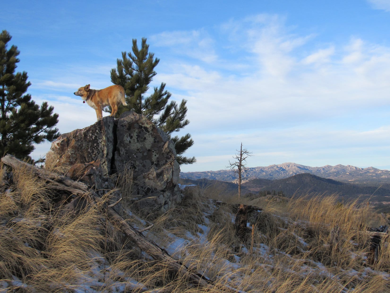
Only 500 or 600 feet S of base camp, Tayo Lake came into view. Most of the lake was still covered in snow and ice. What a beautiful sight it was! It really was a shame to have to leave.

Loop had just been feeling lazy back in her tiny house. There wasn’t a thing wrong with her. On the way down to Tayo Lake, she was bursting with energy. She had a great time racing across the open heather and frisking on big snowbanks.
When Lupe got close to the end of Tayo Lake, SPHP suggested leaving the ridge to go down to the shore near the Tayo Creek outlet. Loopster was in favor of that. She hadn’t actually been to the lake shore on the way to Wind River Peak. This was her last chance to see it.

The water was perfectly still. High rock ridges reflected in the silvery smooth surface. Lupe could hear the nearby gurgling of Tayo Creek starting down the valley. Beyond Tayo Lake was the big green ridge where she’d spent the past two nights in her tiny house at base camp. From there she’d been able to look down on Lake 11,145, now hidden in a cirque above Tayo Lake. Wind River Peak towered over it all. Only yesterday, Lupe had been up there.
After a few minutes lost in contemplation of the magnificent scene, Lupe reminded SPHP it was time to press on. SPHP led Loopster back up onto the ridge. She then started S down wide snowy lanes flanked by stunted forest.
As Lupe descended, SPHP kept watching for the route she had taken up to Tayo Lake 2 days ago, but never really found it. Uncertain whether the Carolina Dog was too far W or E, SPHP led her back and forth in both directions. Lupe traveled over snowfields SPHP was certain she hadn’t been to before. Gradually it dawned on SPHP that Loop was too far W. It wouldn’t really matter, though, would it? The terrain should eventually funnel all routes down to the same general area.
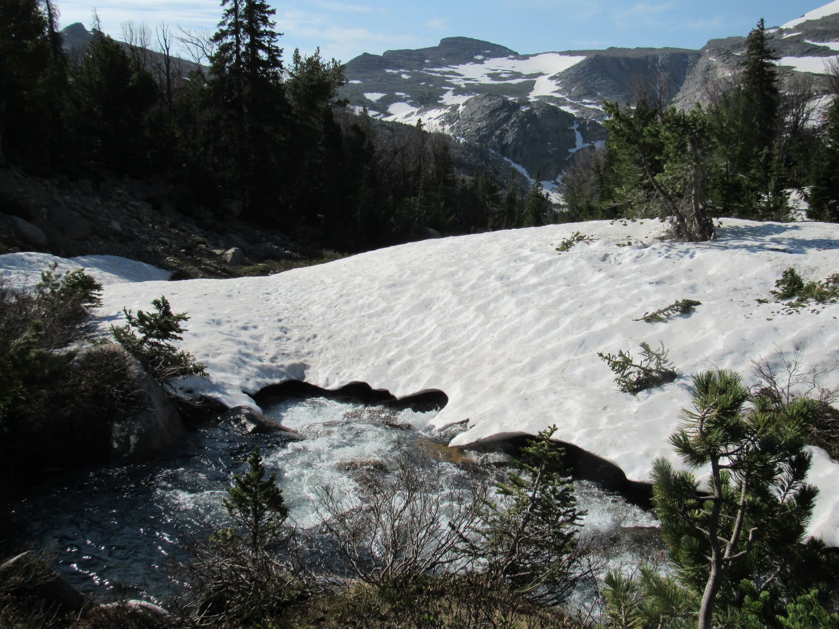
The first indication of a potential problem came when Lupe reached a rushing stream. Cascading swiftly down a narrow channel, the stream was large enough to be Tayo Creek, yet Lupe was W of it. How could that be? Lupe had started off E of Tayo Creek when she left Tayo Lake, and hadn’t crossed it. SPHP was also certain Looper hadn’t crossed or even seen this stream on the way up to Tayo Lake 2 days ago. The maps revealed nothing. Hmm.

Lupe followed the gushing stream down to a large clearing where it fed into a pond. A short distance below the pond, a smaller stream flowed down from the NW to join the larger one. The smaller stream almost certainly had to be Tayo Creek. Tayo Creek wasn’t particularly wide here, but was fairly deep.


Loop needed to get across Tayo Creek, but SPHP didn’t relish the idea of fording it. Near the confluence of the creeks, snow bridges extended over both streams. All the snow banks Lupe had crossed higher up had been strong enough to hold even SPHP’s weight. These snow bridges looked substantial, too.
Just below the confluence, another snow bridge went over the combined streams. If the snow bridge over Tayo Creek collapsed, Lupe might get swept under the downstream bridge where SPHP couldn’t help her.
SPHP tested the snow bridge by the edge of Tayo Creek. It seemed plenty sturdy enough. Lupe would be fine, if she went first.

Lupe dashed across the snow bridge with no problem. SPHP followed. The snow bridge held. Well, that was easy! Way easier than fording the creek would have been.
Lupe was now W of Tayo Creek. She wouldn’t have to cross it again, but knew from experience other big streams were still ahead. The American Dingo followed Tayo Creek S. She ran and sniffed happily in open green forest. Meanwhile, the stream plunged into a narrow canyon. Lupe was losing elevation much more slowly. Tayo Creek was soon far below her.

Tayo Creek disappeared from view. Lupe continued through the forest in a S or SE direction, still losing elevation. A mere 15 minutes after crossing Tayo Creek, Lupe arrived at yet another large stream. This was the stream flowing E from Coon Lake.

The stream from Coon Lake was too wild to ford where Lupe reached it. Loop and SPHP followed it upstream looking for a place to cross. After 15 minutes, SPHP saw a single flat rock that the entire stream was flowing over. The water was shallow and evenly spread. Lupe could cross there!

Lupe had other ideas. While SPHP started for the flat rock, she found some other place to cross the creek. Suddenly, there she was on the opposite S bank!

Having made it over the creek all on her own, Lupe was anxious for SPHP to follow. The big flat rock wasn’t far away, but rocks, trees and a considerable quantity of deadfall made it a struggle to get there. SPHP shouted to Lupe to stay where she was. For several minutes, she did. However, Loop became increasingly concerned as SPHP continued crashing around obstacles on the opposite shore.
When SPHP reached the flat rock, it was possible to see a good snow bridge only a little farther upstream. That would be an even better place to cross! SPHP pleaded with Lupe to remain where she was, but when SPHP turned away she couldn’t wait any longer. Suddenly she was at SPHP’s feet again, fine and dandy. She’d crossed the stream unseen a second time.
Upon reaching the snow bridge, Lupe could see she wasn’t far below a massive snowfield that extended out of sight up the slope to the W. Coon Lake must be up there somewhere, perhaps not too far away. Unfortunately, the already long day ahead meant Lupe didn’t have time for a side trip to go see it. She crossed the creek from Coon Lake for the third time on the snow bridge with SPHP.
S of the creek again, Loop headed SE through the forest. Half an hour went by before she reached another big stream. This was the stream from Mountain Sheep Lake.

Once again, Lupe had reached the stream at a poor place to attempt a crossing. She traveled upstream looking for a better spot, and soon stumbled upon Mountain Sheep Lake itself. The pretty lake was long, narrow, and tucked in a deep side valley off the main canyon Tayo Creek flows through.

A short break was taken to admire Mountain Sheep Lake. When it was over, the problem of where to cross the outlet stream still needed to be resolved. There seemed to be two choices. Not too far downstream from the lake, the creek flowed through a rocky area where it might be possible to rock hop most of the way over.

The other choice was to ford the creek right at the outlet from Mountain Sheep Lake. The stream was wide here, but relatively shallow most of the way. The current was slower, too.

SPHP thought maybe the outlet was the better choice. Convinced Lupe wouldn’t have a problem, SPHP started across, but Loop didn’t follow. SPHP made it to the opposite bank only to turn around and see poor Loop still stranded on the other side. She was intimidated by the width of the stream.

SPHP shouted encouragement to Loop. She could do this!
Lupe hesitated, clearly torn over what to do. She went back and forth along the far bank looking for an answer to her predicament. Finally, as she stood on a rock projecting into the stream, another urging from SPHP seemed to embolden her. She went back to the bank, then waded into the cold water. She had to swim, but only a little bit. Lupe made it across.
SPHP had rewarded Loop with pieces of the last chocolate coconut Cliff bar after she’d crossed Tayo Creek, and again after she’d crossed the creek from Coon Lake. Lupe looked at SPHP expectantly.
Guess, I knew all along you’d get most of this Cliff bar. Here you go, Loop.
I earned it!
Yes, I know. You did great, Looper.
Lupe wouldn’t face another major stream crossing for a long way now. The next landmark she would go by would be Poison Lake, about a mile to the NE. Lupe had a fantastic time in the forest, staying well S of Tayo Creek. The Carolina Dog displayed great energy and enthusiasm, crossing many minor streams and numerous big bogs. She frolicked and cooled off on snowbanks melting away in the soggy forest. She was back in prime squirrel territory, and spent much of her time barking happily.
Going around the SE end of Poison Lake, Lupe returned to the rock platform overlooking the lake she’d been to before on the way up. The sun was almost directly overhead. Time for another break. Lupe and SPHP sat together with a view of Wind River Peak far beyond Poison Lake. What little was left of the chocolate coconut Cliff bar met its doom.

Beyond Poison Lake, Lupe continued following the Tayo River downstream. She didn’t stay as close to it as she had on the way up, since she didn’t need to find a way across. She did see one of the two waterfalls she’d discovered on the way up, but whether it was the upper or lower falls, SPHP didn’t remember.
Lupe had a wonderful time in the forest, but she finally reached Lower Tayo Park again and came to the Middle Popo Agie River. She forded it at the S end of Lower Tayo Park just as she’d done before.


Lupe had finally made it back to a trail! SPHP was curious to see what conditions were like now back at the ford where Trail No. 707 crosses the Middle Popo Agie River below its confluence with Tayo Creek. The situation really hadn’t changed much at all. The ford was still as badly flooded as it was before.
Lupe returned to Middle Fork Trail No. 700, and followed it NE downstream along the Middle Popo Agie River. She was getting close to the junction with Stough Creek Basin Trail No. 704 when a backpacker appeared ahead. He was the first person Lupe and SPHP had seen in 75 hours – more than 3 days.
The backpacker was from Flagstaff, Arizona. He said he was on his way to Tayo Lake, but had nearly turned back at the Stough Creek ford. SPHP explained the situation he would soon face at the flooded ford in Lower Tayo Park, and also described how Lupe had bushwhacked all the way to Tayo Lake and Wind River Peak.

The backpacker went on. Lupe would never know if he made it to Tayo Lake using her bushwhacking route or not. She soon left the Middle Popo Agie River on Trail No. 704 to Stough Creek.
Until now, Lupe had been going downhill nearly all day long. Now she had to climb. The American Dingo did great. She still had plenty of energy to run around looking for squirrels in the forest. SPHP felt played out, though. Going uphill was tough. At least a lot of snow had melted since Lupe had last been here, so it was easier to follow the trail.
Lupe reached the ford at Stough Creek. The situation had not changed from 3 days ago. SPHP still didn’t like the looks of it. Stough Creek was too fast, deep and scary! SPHP was going to have Lupe cross a little upstream of the ford again, then remembered the bridge over Stough Creek near the next trail intersection higher up. Maybe Lupe could just bushwhack up to that bridge?
Loop abandoned the trail for the final bushwhacking session of her Wind River Peak adventure. She hadn’t gone far when she came to a sizable tributary of Stough Creek. Loop forded this lesser creek, and entered a lovely green field that proved to be sopping wet. Another bog! She traipsed across it, and a second one, too, before finally reaching the forest and dry land on the other side.
The off-trail climb through the forest was steep. Lupe came to another major tributary of Stough Creek. It was all whitewater where Lupe reached it.

Lupe followed the tributary upstream to where the terrain leveled out. Here she could ford the tributary without much of a problem. Shortly after crossing the tributary, she found a trail. Lupe followed the trail N. Within 300 feet she arrived at the bridge over Stough Creek. Yes!

Lupe had finally reached Stough Creek Lakes Trail No. 702. It would take her the rest of the way back to the Worthen Meadow trailhead, still a good 5 miles away. Only one major creek crossing remained, Roaring Fork Creek which would come near the end. Onward!

The Carolina Dog was now in a nearly level part of the forest. She soon came to the area where stagnant yellow and orange ponds were scattered among the trees. Up until now, the mosquitoes hadn’t been bad, but here they were terrible.
The climb back up to the high saddle N of High Point 10965 where Lupe had first seen Wind River Peak on her way in was torturous for SPHP, who was nearly exhausted by now. The plucky American Dingo was unfazed. Mosquitoes drove SPHP on. Even when Lupe reached the high saddle, they were bad enough to prevent any long delay. Lupe and SPHP did pause for a few moments, though, to gaze upon the grandeur of Wind River Peak for a final time.

It was still 3 miles back to the Worthen Meadow trailhead from the high saddle. Nearly all of it was downhill, which helped SPHP a great deal. The constant whine of mosquitoes was maddening, but all the Deet was long gone. Lupe busied herself looking for squirrels in the forest. Rest assured American Dingoes never tire of this sport.

At long last, the final ford over Roaring Fork Creek next to Roaring Fork Lake appeared. Lupe ran down to the stream and plunked herself down in the water to cool off.

Roaring Fork Creek didn’t look any different than it had 3 days ago. The water was just as high as before. No matter. In a cloud of mosquitoes, SPHP prepared to cross, then simply went for it.
This time, SPHP stayed upstream of the big rock. The water wasn’t mid-thigh deep here like it was downstream of the rock, but was still several inches over the knee. The even gravelly bottom and gentle current made this ford seem trivial now after all the streams and rivers Lupe had crossed on the way to Wind River Peak and back.
Lupe hadn’t come, though. The water was over her head for a long way. SPHP tried coaxing her from the opposite bank, but without the aid of the enticing chocolate coconut Cliff bar, Lupe stayed put. Seeing further entreaties were futile, SPHP dumped the backpack and waded back into the stream.
As soon as Lupe saw help was on the way, she plunged into Roaring Fork Creek and started swimming toward SPHP. She remembered being on the big rock SPHP had put her on before midstream and swam to it. However, the rock was steep where she reached it. She tried, but Lupe couldn’t get up on it by herself. The current carried her out of sight behind the rock.
Lupe didn’t reappear downstream. What was happening? No doubt she was still striving to get up on the rock, but SPHP couldn’t see her. Before SPHP could get there, Loop grew fearful and gave up. Suddenly she was in view again heading back to shore. SPHP continued over to get her.
SPHP picked the cold, drenched Carolina Dog up, and carried the grateful, dripping Dingo across Roaring Fork Creek. Lupe’s last adventure of her 4 day journey to Wind River Peak was over.
At Worthen Meadow Reservoir, Lupe lost no time hopping into the G6 (9:00 PM). She curled up on her pillows and blankets, licked herself clean, and devoured an entire can of Alpo. She still had room for a McDonald’s cheeseburger in Lander an hour later. The night time scene at Lander City Park was astonishing. The place was absolutely packed with tents and RV’s.
SPHP took the last parking spot available. It was right beneath a bright streetlight. For some strange reason the streetlight cycled on and off at 30 second intervals. After Lupe’s long march all the way from Tayo Lake, it was only a minor annoyance. Lupe and SPHP were both fast asleep, dead to the world, still dreaming of fabulous Wind River Peak.
Related Links:
Wind River Peak, Wyoming – Part 1: Worthen Meadow to Tayo Park (7-8-17 & 7-9-17)
Wind River Peak, Wyoming – Part 2: Divide & Conquer – Tayo Park to Tayo Lake (7-10-17)
Wind River Peak, Wyoming – Part 3: Tayo Lake to the Summit (7-11-17)
You might also like:
Big Sandy to Jackass Pass & Cirque of the Towers, Wind River Range, WY (9-1-15)
Cirque of the Towers, Lonesome Lake, Skunk Knob & Jackass Pass, Wind River Range, WY (9-2-15)
Want more Lupe adventures? Choose from Lupe’s 2017 Wind River Range in Wyoming & Select Peaks in Montana Adventure Index, Dingo Vacations Adventure Index or Master Adventure Index. Or subscribe free to new Lupe adventures.