Striving for Squaretop Mountain, Wind River Range, WY – Part 2: New Benchmark – Victory & Defeat! (7-15-17)

Day 8 of Lupe’s 2017 Dingo Vacation to the Wind River Range, Wyoming & Select Peaks in Montana

Before the sun was up, Lupe wanted out of her “tiny house”.  SPHP unzipped the door and let her go.  The Carolina Dog must have slept well.  She hadn’t been so perky last evening after her long trek to Porcupine Pass from Lower Green River Lake.  SPHP dozed a bit longer.  When SPHP finally emerged, Loop was busy watching 3 deer and a marmot.

Sweet!  Having a great time watching wildlife, aye Looper?

Oh, yes!  It turns out this Porcupine Pass is a terrific spot.  Don’t make any sudden movements, and please be quiet so the deer don’t run away!

Sorry, but we’ve got to get going, Loop.  Today’s the big day.  Squaretop Mountain or bust!  Before we head for New Benchmark, want to take a stroll up Porcupine Pass Peak for a better look at what we’re facing?

Sure!  Let me know when you’re ready.  I’m going to keep watching these deer till then.

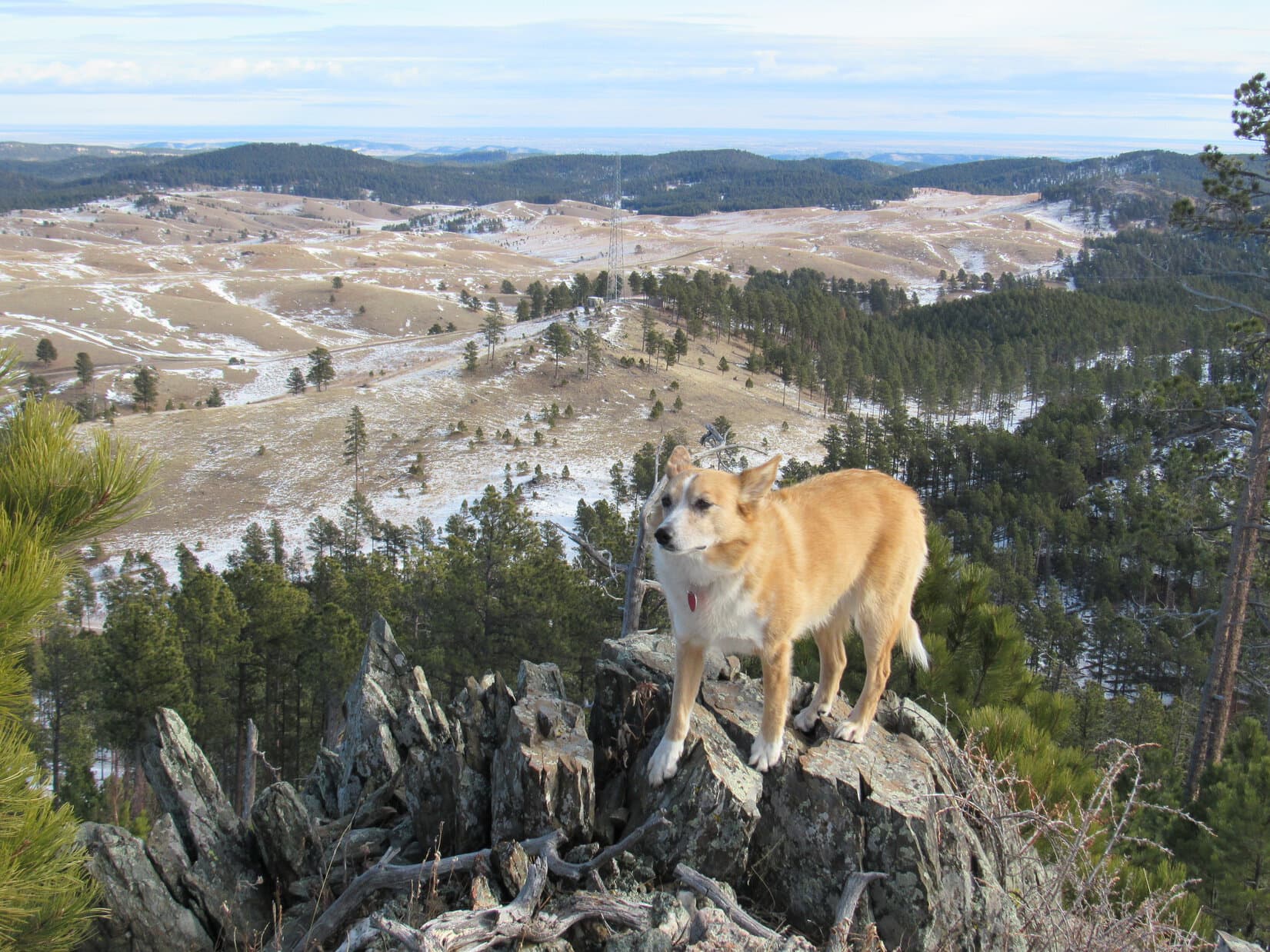
Porcupine Pass Peak (10,890 ft.) is a barren hill on the SW side of Porcupine Pass.  Lupe gained less than 200 feet of elevation on her way to the top.  The stroll was an easy one, free of obstacles except for a steep snowbank just below the rim of the summit area.  Fortunately, the snowbank wasn’t large.  SPHP found a way around most of it.  The snow presented no problem at all to the American Dingo, who powered her way right on up, chomping snow for moisture as she went.

The top of Porcupine Pass Peak proved to be a large, gently rounded area, carpeted with green alpine plants.  Not a tree or bush anywhere.  Medium-sized rocks laid thinly scattered across the field.  In every direction, Lupe gazed upon magnificent mountains and huge valleys.

Looking down Porcupine Creek valley from Porcupine Pass Peak. Lupe had come up this valley yesterday on her way to Porcupine Pass where she’d spent the night. Photo looks N.
Looking W.
Lupe at the true summit of mighty Porcupine Pass Peak. Photo looks SW.
Looking S.
Looking SE across the Dodge Creek valley S of Porcupine Pass. Peak 11,290 is on the R.
Looking down on Porcupine Pass from Porcupine Pass Peak. Lupe’s tiny house where she’d spent the night is in sight. Peak 11,565 is on the L. Photo looks NE.

Beauty was everywhere, but the view to the E from Porcupine Pass Peak was disconcerting.  Beyond Porcupine Pass, Lupe had her first good look at New Benchmark (11,850 ft.).  The mountain was bigger, higher, and considerably more rugged than SPHP expected.

New Benchmark was the first of two major obstacles Lupe would face on her intended route to Squaretop Mountain (11,695 ft.).  Once safely past it, she would reach more favorable terrain on the way to Peaks 11,820 and 11,590.  The second obstacle she would come to was a steep drop down to a narrow saddle leading to Peak 11,415.  If Loop could cross that saddle, the remaining 1.5 miles N to the summit of Squaretop should be relatively easy.

Easy?  Too funny!  Staring only at maps, SPHP had been optimistic Lupe wouldn’t face anything more serious than a long ridge walk to get to Squaretop Mountain from Porcupine Pass today.  Now that the Carolina Dog was actually here, staring at the reality of New Benchmark, it was clear nothing about this was going to be easy.

Come on, Loopster!  We’ve got a gargantuan day ahead of us.  We’d best get on with it!

New Benchmark from Porcupine Pass Peak. Photo looks E.

Down at Porcupine Pass, SPHP disassembled Lupe’s tiny house.  It was now perfectly clear she wasn’t likely to get all the way to Squaretop Mountain and back again in a single day.  Everything had to come with.

Lupe and SPHP left Porcupine Pass.  The Carolina Dog lost a bit of elevation heading ESE over to the base of a long, steep, scree and talus slope.  This slope was the first big climb on the way up New Benchmark.

Lupe sniffs around at the base of the first steep rocky climb on the way up New Benchmark. Photo looks E

Lupe started climbing NE up the rough slope.  Looper had no trouble maneuvering around, but SPHP was slow as always.  Steady progress was being made, but it took a long time.  While SPHP struggled up, Lupe enjoyed scanning the rocky terrain from increasingly lofty perches.  Now and then, she encouraged SPHP to keep climbing.

Nearing the end of the steepest part of the first climb. Photo looks N.
Looking W back at Porcupine Pass (on the R straight up from Lupe’s head), and Porcupine Pass Peak (the low ridge in the foreground on the other side of upper Dodge Creek valley).

After a long way up, the terrain finally became less steep.  The rocks were bigger here, which was sometimes a help and sometimes a hindrance.  Lupe appeared to be coming to some kind of a top.

After a long climb, Lupe reached an area of larger rocks where the terrain wasn’t as steep. She appeared to be nearing some kind of a top. Photo looks E.

Loop reached a top alright, but it wasn’t the top of New Benchmark.  She was only halfway there on a false summit.  The false summit was a large area of rough ground full of big rocks and boulders.  Overall it was fairly level.  It wasn’t hard to move around here, which was encouraging.  SPHP was finally able to pick up the pace.

Lupe on the false summit 0.5 mile W of New Benchmark after the first big climb. Photo looks W.

The highest parts of the false summit were toward the SSE, but Lupe went only partway there.  A broad, relatively shallow saddle came into view leading NE to New Benchmark.

Halfway there! To New Benchmark (Center), that is. Squaretop Mountain wasn’t even in sight yet. Photo looks ENE from the false summit at the end of the first climb.

Much to her delight, the American Dingo got to romp across a big, gently sloping snowfield on her way down to the saddle.  At the saddle, she saw two beautiful pale blue tarns surrounded by ice and snow in a cirque below her to the NW.

Lupe on the saddle between the false summit and New Benchmark. She was impressed with the beauty of the two pale blue tarns surrounded by snow and ice seen below. Photo looks NW.

Once across the saddle, Lupe angled E.  The second big climb was about to begin.  Loop would have to gain just as much elevation as on the first leg up, but the terrain wasn’t quite as steep here.  It wasn’t nearly as rocky, either, which helped SPHP tremendously.  Lupe followed lanes of vegetation staying above, and safely away from, huge SW-facing cliffs.

Looking E from the saddle area at the 2nd and final big climb on the way up New Benchmark. The summit is R of Center. Lupe followed lanes of vegetation staying well above and away from the cliffs seen on the R. Photo looks E.

Suddenly, things were going well!  SPHP was able to climb much faster here.  Heart, lung and leg power were the only limitations.  SPHP could plod steadily upward instead of scrambling slowly among rocks.  Lupe was going to make it to the top of New Benchmark!  The question now was, what would she find on the other side?  Could she continue on to Squaretop Mountain?

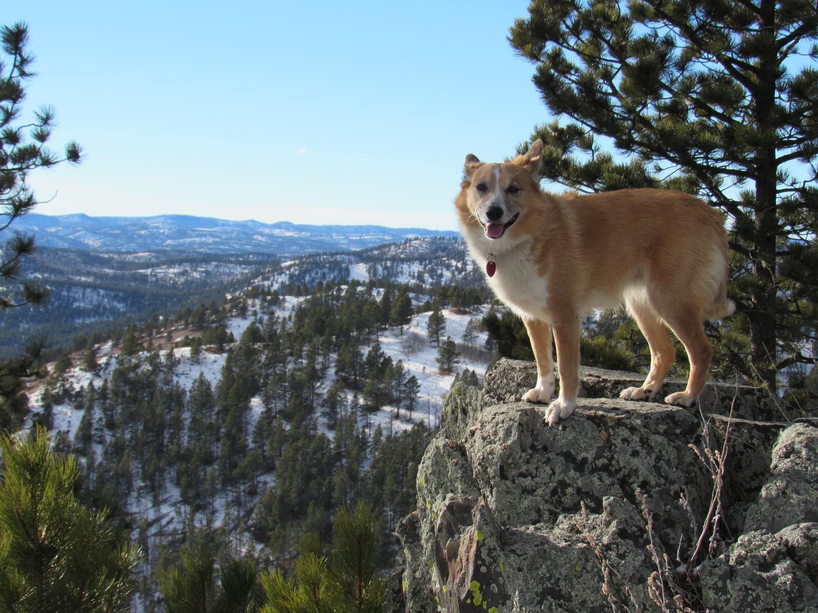
Lupe and SPHP approached the summit full of hope.  Before long, the Carolina Dog was there, perched atop New Benchmark’s highest rocks!  New Benchmark (11,850 ft.) was a glorious peak in its own right.  The views of the Wind River Range were fantastic!

Lupe at 11,850 feet on top of New Benchmark. The views of the Wind River Range were spectacular! Photo looks SW.
Victory at New Benchmark! Lupe stands atop the summit. Photo looks N.
On another rock slightly below the summit that made a great Dingo perch. Photo looks NW with help from the telephoto lens.

New Benchmark’s summit area was fairly large and flat.  The highest rocks were along the NW edge.  Lupe and SPHP searched around for a registry or a survey benchmark, but found neither.

Looking NW at New Benchmark’s true summit (Center). Less than half of the summit area is in view here. Lupe & SPHP searched, but didn’t find a registry or survey benchmark (new or old!) anywhere.

While the views were grand in all directions, some of the most spectacular peaks were off to the E and SE along the continental divide.  Lupe could see Gannett Peak (13,804 ft.), the highest mountain in Wyoming.

Lupe along the SE edge of the summit area. A huge chasm was between her and the upper S ridge of Peak 11,820 (L). However, she could see over both the chasm and the ridge for a good look at Gannett Peak (on far L), the highest mountain in Wyoming. Photo looks ESE.
Gannett Peak (L) with help from the telephoto lens. Photo looks ESE.
The view to the SE from New Benchmark.

Reaching the summit of New Benchmark was a peakbagging victory for Lupe.  Her ultimate objective, however, was still Squaretop Mountain (11,695 ft.).  She could see it from New Benchmark, about 3.5 miles to the NE as the crow flies.  In fact, she was looking down on it.

Lupe could see Squaretop Mountain, her ultimate objective, from New Benchmark. The top of Squaretop is the flat barren ridge seen beyond the closest chasm. Photo looks NE with lots of help from the telephoto lens.

The news wasn’t good, though.  To get to Squaretop Mountain, Lupe needed to be able to get from New Benchmark over to easier terrain near Peak 11,820 to the E.  Cliffs eliminated any possibility of going directly E or SE, but the topo map showed Lupe ought to be able to go down New Benchmark’s NNE slope and reach a saddle leading E.  This route shouldn’t be any steeper than the route Lupe had taken up New Benchmark.

Lupe started down New Benchmark’s NNE slope, only to discover a huge, long snowbank wrapped around the N and NE side of the mountain.  The snow curved steeply away out of sight.  How far down the snow went, and how steep it became was impossible to tell.  Unequipped, SPHP wasn’t willing to walk out on the snow far enough to tell.  A slip might easily become a rocket slide hundreds of feet onto deadly rocks below.

Looking for a way over to the Peak 11,820 area, Lupe went partway down New Benchmark’s N slope. However, a huge snowbank wrapped around the N and NE sides of the mountain sloped steeply out of sight. Photo looks N.

The sky had been partly cloudy all morning.  For the last several hours, it had been especially cloudy to the NE.  It hadn’t look threatening, though, and Lupe had spent a full hour up on New Benchmark’s superb summit.  Now, as Loop stood on rocks above the steep snowbank gazing E, dark clouds and rain were sweeping over the continental divide not too many miles beyond Squaretop Mountain.

As Lupe stood on rocks of New Benchmark’s N slope looking for a way to the easier terrain she could see to the E beyond the steep snowbank, dark clouds and rain swept over the continental divide. Gannett Peak (R) is on the horizon straight up from Lupe’s head. The flat top of Squaretop Mountain is along the L edge of this photo. Photo looks E.

Not looking too good, is it, SPHP?

No, not really, Loop.  So frustrating!  This route has been more challenging than I expected, but it should have worked.  If this snowbank wasn’t here, I still believe we would have been able to scramble down this slope easily enough and continue E.

Would we have made it to Squaretop then?

Not sure, but we certainly could have gotten a lot closer.  Once beyond New Benchmark, it looks like a cinch to get at least as far as Peak 11,590.  Beyond that, who knows?  Can’t tell from here.  Maybe there isn’t a safe route across the saddle to Peak 11,415?  That would have been the last real obstacle, though.

So now what?  Are we beaten?

Looks like it, Loopster.  We’re staring at defeat here as far as Squaretop Mountain is concerned.  Weather’s looking kind of iffy, anyway.  Even if we could continue on, it might not be the smartest thing to spend the rest of the day sauntering around on exposed mountaintops.

Well, don’t take it too hard, SPHP.  We made it to New Benchmark, didn’t we?  That was a peakbagging victory.  New Benchmark is a splendid mountain, wouldn’t you say?

Oh, yes, indeed!  New Benchmark is awesome!  It’s a grand consolation prize as your peakbagging goes.  Still, as far as our original intentions went, this day has been a small victory, and a major defeat.  Had my heart set on Squaretop Mountain for you.  Thought we would be there today.  Really did.

Oh, whaa, whaa!  Get over it, SPHP.  Look at where we are, high in the glorious Wind River Range!  Let’s have fun!  We going back to Porcupine Pass now?

Yeah, I suppose we better.  No sense arguing with reality in the mountains, especially mountains as big as the Winds.  Onward, sweet puppy!

Now you’re talking!  Maybe the deers and marmot will still be there?  I hope so!

By the time Loop made it around to the W side of New Benchmark to start the first big descent, a storm could be seen approaching.  The surprising thing was that it was coming from the W where the sky had been relatively clear, instead of from the E.  The storm was quite some distance away, so it appeared the Carolina Dog still had time to carry on for a while.

Halfway down to the saddle leading to the false summit, suddenly the whole sky turned gray.  Clouds were forming directly overhead.  Light rain fell.  More was certainly on the way.  Continuing down the mountain, SPHP started looking for a place where Lupe could take shelter.  Some tall rocks with a slight overhang was all that was on offer.  Lupe reached this refuge moments before the downpour began in earnest.

It rained hard for half an hour, with pea-sized hail thrown into the mix toward the end just for fun.  Lupe was fairly well protected by the little overhang.  The Carolina Dog emerged from the experience only a bit damp.  SPHP, however, was thoroughly drenched.  Only SPHP’s head and shoulders had been spared.

Ha, ha!  Look at you, SPHP!  For once, you’re the drowned rat.  Usually I’m the soggy doggie!

Heh, that was a bit more refreshing than it needed to be, alright.  Come on, Looper, let’s move it!  The storm isn’t over yet.  Let’s get down to the saddle during this break.

Good idea.  I remember some really big rocks down there.  We can find a better place to hide!

Stray raindrops continued falling all the way down to the saddle.  Lupe was right about the big rocks.  The saddle featured a collection of huge boulders all jumbled together.  Loop and SPHP found a much larger overhang, almost like a cave.  Not a moment too soon, either.  No sooner was the American Dingo safe inside than the next downpour began.

This time it didn’t rain quite as hard.  A cold wind blew instead.  Another shot of pea-sized hail fell.  The cave wasn’t very big.  It would have been considerably more comfortable, if the ceiling had been higher and dripped less.  SPHP sat scrunched over on a small rock, watching water trickle down the wet ceiling, while Loop stared out of the cave.  Hopefully it would all be over soon.  This wouldn’t be such a great way to spend the night.

After 20 minutes, the rain tapered off.  A small patch of blue sky appeared.  Lupe watched the patch grow for 10 minutes before it seemed safe to venture out.  Scattered raindrops carried on the breeze continued falling as Lupe and SPHP headed SW toward the false summit.  By the time Lupe was there, the rain was over.

Lupe back on some of the big rocks in the area of the false summit. The rain was over now. Photo looks W.

As Lupe began the final big descent, the sky began to clear.  The lucky American Dingo would enjoy sunshine the rest of the way back to Porcupine Pass.  As usual, it took SPHP a long time going down the steep, rocky slopes.  It didn’t matter, though.  The air was fresh and clean, the sky blue, the mountains gorgeous.

Victory and defeat!  This was living the life of Lupe.  She had it better than Riley ever did!

On the final descent to Porcupine Pass. Photo looks SW.
Relaxing in the evening next to the tiny house in Porcupine Pass after the journey to New Benchmark and back, 7-15-17.

Related Links:

Striving for Squaretop Mountain, Wind River Range, WY – Part 3: The Dome Peak Salvage Operation (7-16-17)

Striving for Squaretop Mountain, Wind River Range, WY – Part 1: Lower Green River Lake to Porcupine Pass (7-13-17 & 7-14-17)

Green River Lakes, Squaretop Mountain & the Highline Trail to Beaver Park, Wind River Range, WY (8-30-15)

Want more Lupe adventures?  Choose from Lupe’s 2017 Wind River Range in Wyoming & Select Peaks in Montana Adventure IndexDingo Vacations Adventure Index or Master Adventure Index.  Or subscribe free to new Lupe adventures.

Black Hills, SD Expedition No. 221 – Peak 5800 & New Year’s Eve Peak (1-7-18)

Start – Intersection of Hwy 385 & USFS Road No. 710, 10:26 AM, 40°F

Lupe was late, a whole week late, but it wasn’t her fault.  She’d spent the last several days of 2017 in the Denver area visiting babies Felix and Owen, and having adventures with cousin Dusty.  The weather had been frigid, anyway, in the Black Hills.  It was still 5 below zero when Lupe returned home on New Year’s Eve 2017, and that was the high on New Year’s Day 2018.

Loop had climbed Peak 6046 for the first time on New Year’s Eve 2012 way back when she was barely 2 years old.  Since then, returning near the end of each year or the beginning of the next, had evolved into a tradition.  As far as the American Dingo and SPHP were concerned, Peak 6046 had become New Year’s Eve Peak (6,046 ft.).  Now, even though Lupe was a week late, returning to New Year’s Eve Peak seemed like a must for her first Black Hills, SD Expedition of 2018.

It’s odd that it would matter, but this year felt a bit different due to the later date.  SPHP decided to shake things up a bit.  Lupe would take a slightly different route from her favorite one in recent years.  Instead of following USFS Road No. 710 W up a valley N of Peak 5800, Lupe would start by climbing Peak 5800 instead.  She’d only been on Peak 5800 once before.  She’d climbed the mountain from the W after visiting New Year’s Eve Peak first on New Year’s Day 2016.

Lupe didn’t care what route SPHP wanted to try.  The Carolina Dog was just glad that it was finally warm enough to go out on an expedition in the hills!  So instead of taking USFS Road No. 710, SPHP had her skip the road entirely and head SW straight for Peak 5800.

Lupe starts out for Peak 5800 on her first Black Hills, SD Expedition of 2018! Photo looks WSW.

Despite the recent bitter cold temperatures, this part of the Black Hills hadn’t received much snow so far this winter.  Several inches blanketed the NE slopes of Peak 5800, but that was only half as much as Lupe was used to seeing in this area in recent years.

Without any definite route in mind, Lupe and SPHP wandered up the mountain.  Peak 5800 has two NE ridges.  Looper soon chanced upon on the one farthest S, which ultimately leads to the lower SE part of the big main summit ridge.  The Carolina Dog was in snowy forest most of the way up.  As she got higher, she started coming to rock formations, some of which provided decent viewpoints.

At one of the rock formations Lupe reached early in her ascent. The large patch of prairie below is known as the Bald Hills. Photo looks ENE.
Loopster had a good view of several mountains she was familiar with from this snowy ledge. Silver Mountain (5,405 ft.) is on the horizon at Center. Boulder Hill (5,331 ft.) is to the L. Part of frozen Sheridan Lake is straight up from Lupe’s head. The high point beyond the lake is Calumet Ridge (5,601 ft.). Photo looks SE.
Lupe astride a particularly rocky point on the way up Peak 5800‘s southernmost NE ridge. Photo looks SW.

Lupe reached the top of Peak 5800’s long, broad summit ridge near a high point close to its SE end.  This high point wasn’t the true summit, which was still some distance to the NW.  Since the broad ridge isn’t heavily forested, Loop already enjoyed some rather nice panoramas.

Loop on a handy Dingo display rock near the lower SE end of Peak 5800’s summit ridge. Black Elk Peak (7,231 ft.) (L) and Five Points (6,221 ft.) (R) are in view. Photo looks SSW.
Looking SE again. In the distance are Silver Mountain (Center), Boulder Hill (L) and Calumet Ridge (R, beyond Sheridan Lake).
A cheerful Dingo with a grand view of her Black Hills from Peak 5800 on the first expedition of 2018. What a glorious, huge dog park! Photo looks SW.
Lupe at the highest point at the SE end of Peak 5800’s summit ridge. The true summit is in view beyond her. New Year’s Eve Peak is the highest distant forested hill on the L. Photo looks NW.

After a look around from the SE end of the summit ridge, Looper sniffed her way NW to the true summit.  An easy 10 minute stroll and she was there.

Loopster reaches the true summit of Peak 5800! The Seth Bullock fire lookout tower is just visible on Scruton Mountain (5,922 ft.) (L). Photo looks NNW with some help from the telephoto lens.
The Seth Bullock fire lookout tower on Scruton Mountain (L) is easily seen in this photo. Custer Peak (6,804 ft.) is the pointy peak R of Center. Photo looks NNW with lots of help from the telephoto lens.
New Year’s Eve Peak (6,046 ft.) (Center) from Peak 5800. Scruton Mountain is at the far R. Photo looks NW.
Looking SE back along Peak 5800‘s broad summit ridge. Sheridan Lake is on the R.
Looking WSW from the summit of Peak 5800.

The sweeping views from Peak 5800 were actually grander than what Lupe would see from New Year’s Eve Peak, but Loop was still going on.  A chilly W breeze encouraged her not to linger too long at Peak 5800’s summit.  She left it heading W, and was soon picking her way down through boulders on the mountain’s W face.

Looking back at Peak 5800 after picking a way down through the boulders on the mountain’s W face. Photo looks E.

Once below the boulder field, Lupe and SPHP headed NW across rolling fields and hills.  This is a favorite area.  A fire had burned the forest here years ago.  Young pines now dot the landscape in some places, but most of the terrain is grassy.  Sharp rock formations exist scattered along the edge of high ground overlooking territory that slopes S down toward the Horse Creek valley.

Lupe on one of the sharp rock formations along the edge of the higher ground. Photo looks W.
Looking S. Black Elk Peak (L), Five Points (R) and False North Point (far R) are in view.

Approaching High Point 5917 from the SE, Lupe rejoined her usual route to New Year’s Eve Peak.  She turned W staying S of High Point 5917, and crossed a saddle leading to the SE end of New Year’s Eve Peak’s S ridge.  On the W side of the saddle she faced two steep snowy climbs in succession.  Neither was particularly long, but the first one was both longest and steepest.

Looper reached Pistol Point, a traditional stopping point on the way to New Year’s Eve Peak.  SPHP had named it Pistol Point after a large rock that looks like the handle of a big pistol jutting up out of the ground.  The Carolina Dog could see the top of New Year’s Eve Peak (6,046 ft.) from here.

Lupe on one of the large rocks in the Pistol Point area. The forested summit of New Year’s Eve Peak (Center) is seen beyond her. Photo looks NNW.
View to the W from Pistol Point. Pistol Point is the high point at the SE end of New Year Eve Peak‘s S ridge, and a favorite stopping point.
Looper stands next to the pistol handle at Pistol Point. Photo looks E.

After climbing around on the rocks checking out the views from Pistol Point, Lupe headed W.  She was already on New Year’s Eve Peak’s S ridge, which soon swept around to the N.  The ridge became narrower, rockier, and more heavily forested as Lupe continued on, before finally widening out again upon reaching New Year’s Eve Peak’s upper S slope.

A few more minutes and Lupe was there, standing atop the boulder at the summit of New Year’s Eve Peak (6,046 ft.).

Looper on New Year’s Eve Peak‘s summit boulder. This was her 5th ascent of the mountain. Photo looks WSW.
On top of New Year’s Eve Peak. A cairn can be seen behind Lupe. The cairn wasn’t here the first time Lupe climbed the mountain on 12-31-12. She had seen it for the first time on her 1-1-16 ascent. Photo looks N.

The first two times Lupe had climbed New Year’s Eve Peak, the summit area had all been heavily forested.  It had been hard to get much more than a glimpse of a view in any direction.  New Year’s Eve Peak used to have a shady, dark, gloomy feel to it, an atmosphere which fit in with being here alone at the end of a dying year.

Sometime during 2015, loggers had come.  When Lupe had arrived on New Year’s Day 2016, the S end of the summit area and part of the S slope below it had been cleared.  Lots of slash and dead logs had been left to stumble around upon.  The affected area was relatively small, but the logging created good, open views to the S and SE.  Ever since then, the summit has been brighter and cheerier.

Somehow Lupe and SPHP preferred it the old way, yet that didn’t mean there was any reason not to take a look around.

Looking SE from New Year’s Eve Peak. Calumet Ridge (5,601 ft.) (Center) is seen beyond Sheridan Lake. Silver Mountain (5,405 ft.) is on the L, and Boulder Hill (5,331 ft.) on the far L.

A chilly 20 mph W wind was blowing.  It had been 40°F when Lupe and SPHP left the G6 this morning.  It didn’t feel like the day had warmed up a bit since then.  Lupe and SPHP sat huddled together at the W edge of the summit facing the cold wind, pondering the beautiful winter scene, the passage of 2017, and start of 2018.

Looking WSW with some help from the telephoto lens.

Lupe munched on Taste of the Wild.  She had been eating snow, and didn’t want any water.  SPHP hadn’t brought anything else.

It’s funny what the mind is capable of.  Every other time Loop had been here, the mood had been melancholy, especially when she’d been here right on New Year’s Eve.  There was something psychologically depressing about watching the sun sink toward the horizon, and the light of day disappear for the last time on a year that had been part of the unknown future not so long ago.  A year now rapidly passing away never to be seen or experienced again.

The years when Loop had been here on New Year’s Day instead of right on New Year’s Eve, some of that sadness still lingered.  However, it was already being counterbalanced to a degree by the hope, brilliance and excitement of the new year just beginning.

Perhaps it was partially because Lupe was here earlier in the day today than on previous years, while the sun was still relatively high in the sky.  As the Carolina Dog and SPHP sat facing the cold wind, it no longer felt possible to truly mourn the passing of 2017.  Surprisingly, with only 2% of 2018 now history, the new year no longer seemed quite as completely bright and shiny as it had been a week ago, either.  The mind had already made the adjustment and moved on.

It only felt cold.  And like Lupe really had arrived late.  Not terribly late, but late.  It was good to be here, though, together again, on top of New Year’s Eve Peak peering out at the quiet, familiar wintry scene last gazed upon a little more than a year ago.  Loopster’s 2018 adventures were now underway.  That was a good thing.  2017 had been a fabulous year, and 2018 was still a 98% clean slate with many adventures to come.  Her annual pilgrimage to New Year’s Eve Peak complete, Lupe was ready to press on.

Puppy ho!  She was right, no sense sitting in the cold wind too long.  Lupe returned briefly to the summit boulder.

Loop on New Year’s Eve Peak‘s summit boulder once again. Photo looks N.

Even though this year’s experience wasn’t quite the same, coming here today had been better late than never.  Lupe and SPHP bid farewell to New Year’s Eve Peak, promising to return again, hopefully right when New Year’s Eve finally rolled around again many adventures from now.  Then Lupe led the way down the mountain’s S slope to retrace her route along the S ridge back to Pistol Point.

On a ledge early on the way down the S slope. Photo looks W.
At an opening along New Year’s Eve Peak‘s upper S slope. Photo looks WSW.
Lupe reaches the transition point between the S slope and S ridge. Photo looks S.
Peak 5800 (Center) from rocks near Pistol Point. Photo looks ESE.

It felt good to be moving again.  Lower down the W wind was demoted to a mere breeze.  The slanting afternoon sunlight highlighted details of the terrain.  Growing shadows added contrast.  All the way back to the G6, Lupe ran and played in a beautiful world.  2018 was finally off to a good start!  (3:42 PM, 33 °F)

Looking S from the S slopes of High Point 5917.
On USFS Road No. 710 taking the traditional route back to the G6. High Point 5917 is on the R. Photo looks W.

Links:

Next Black Hills Expedition                      Prior Black Hills Expedition

Expedition No. 187 – New Year’s Eve Peak (12-30-16)

Expedition No. 242 – New Year’s Eve Peak, Peak 6070 & Peak 6043 (12-17-18)

Want more Lupe adventures?  Check out her Black Hills, SD & WY Expeditions Adventure Index, Master Adventure Index, or subscribe free to new Lupe adventures!