Lupe was late, a whole week late, but it wasn’t her fault. She’d spent the last several days of 2017 in the Denver area visiting babies Felix and Owen, and having adventures with cousin Dusty. The weather had been frigid, anyway, in the Black Hills. It was still 5 below zero when Lupe returned home on New Year’s Eve 2017, and that was the high on New Year’s Day 2018.
Loop had climbed Peak6046 for the first time on New Year’s Eve 2012 way back when she was barely 2 years old. Since then, returning near the end of each year or the beginning of the next, had evolved into a tradition. As far as the American Dingo and SPHP were concerned, Peak 6046 had become New Year’s Eve Peak(6,046 ft.). Now, even though Lupe was a week late, returning to New Year’s Eve Peak seemed like a must for her first Black Hills, SD Expedition of 2018.
It’s odd that it would matter, but this year felt a bit different due to the later date. SPHP decided to shake things up a bit. Lupe would take a slightly different route from her favorite one in recent years. Instead of following USFS Road No. 710 W up a valley N of Peak 5800, Lupe would start by climbing Peak 5800 instead. She’d only been on Peak 5800 once before. She’d climbed the mountain from the W after visiting New Year’s Eve Peak first on New Year’s Day 2016.
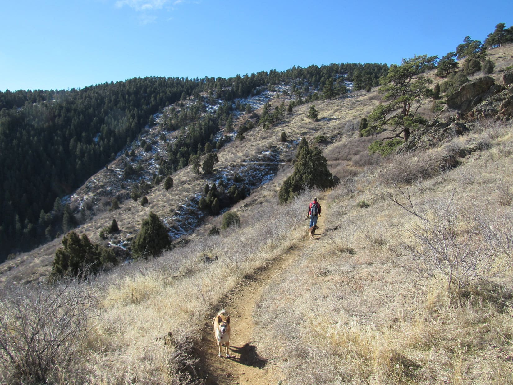
Lupe didn’t care what route SPHP wanted to try. The Carolina Dog was just glad that it was finally warm enough to go out on an expedition in the hills! So instead of taking USFS Road No. 710, SPHP had her skip the road entirely and head SW straight for Peak 5800.
Lupe starts out for Peak 5800 on her first Black Hills, SD Expedition of 2018! Photo looks WSW.
Despite the recent bitter cold temperatures, this part of the Black Hills hadn’t received much snow so far this winter. Several inches blanketed the NE slopes of Peak 5800, but that was only half as much as Lupe was used to seeing in this area in recent years.
Without any definite route in mind, Lupe and SPHP wandered up the mountain. Peak 5800 has two NE ridges. Looper soon chanced upon on the one farthest S, which ultimately leads to the lower SE part of the big main summit ridge. The Carolina Dog was in snowy forest most of the way up. As she got higher, she started coming to rock formations, some of which provided decent viewpoints.
At one of the rock formations Lupe reached early in her ascent. The large patch of prairie below is known as the Bald Hills. Photo looks ENE.Loopster had a good view of several mountains she was familiar with from this snowy ledge. Silver Mountain(5,405 ft.) is on the horizon at Center. Boulder Hill(5,331 ft.) is to the L. Part of frozen Sheridan Lake is straight up from Lupe’s head. The high point beyond the lake is Calumet Ridge(5,601 ft.). Photo looks SE.Lupe astride a particularly rocky point on the way up Peak 5800‘s southernmost NE ridge. Photo looks SW.
Lupe reached the top of Peak 5800’s long, broad summit ridge near a high point close to its SE end. This high point wasn’t the true summit, which was still some distance to the NW. Since the broad ridge isn’t heavily forested, Loop already enjoyed some rather nice panoramas.
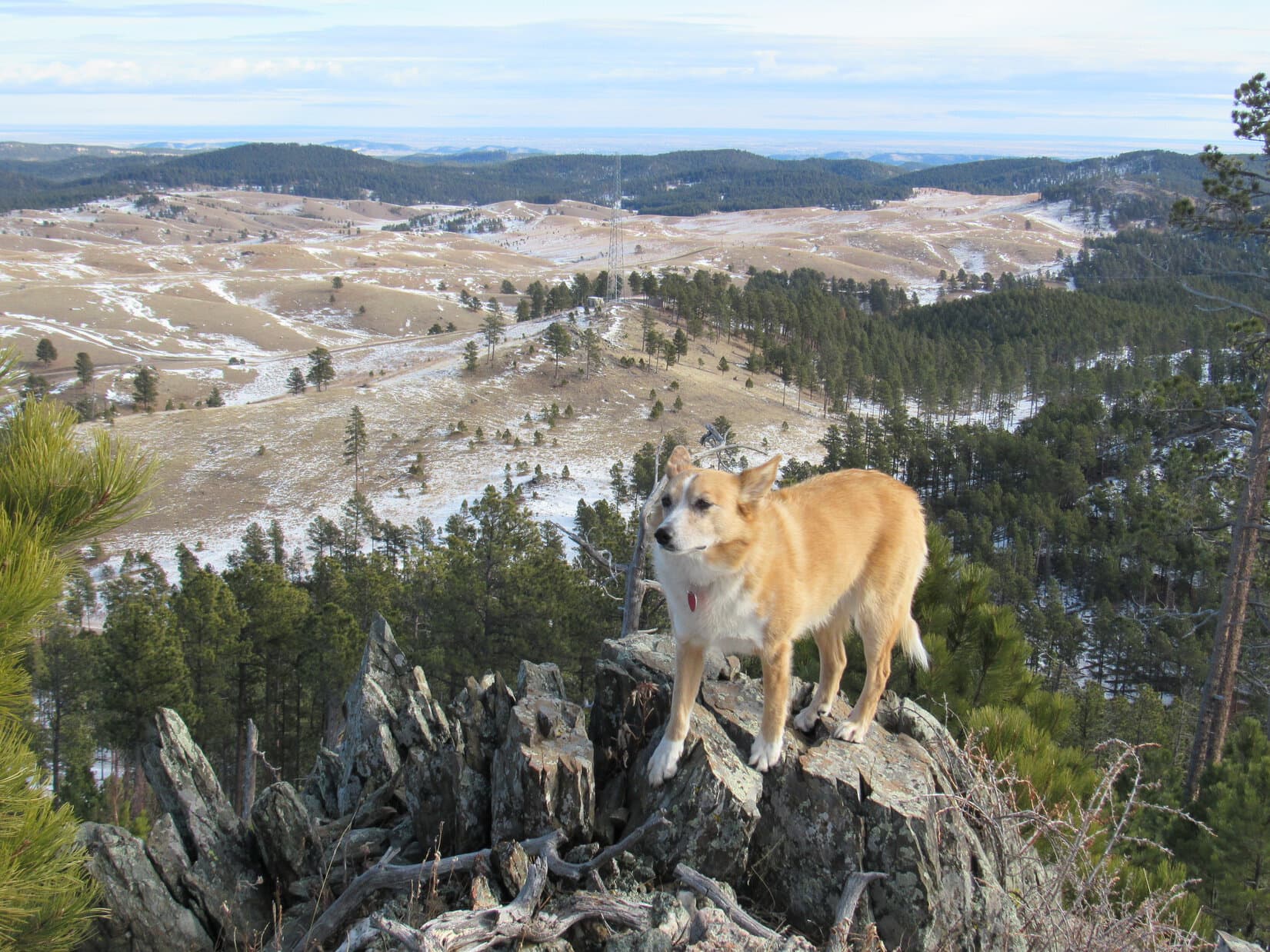
Loop on a handy Dingo display rock near the lower SE end of Peak 5800’s summit ridge. Black Elk Peak(7,231 ft.) (L) and Five Points(6,221 ft.) (R) are in view. Photo looks SSW.Looking SE again. In the distance are Silver Mountain (Center), Boulder Hill (L) and Calumet Ridge (R, beyond Sheridan Lake).A cheerful Dingo with a grand view of her Black Hills from Peak 5800 on the first expedition of 2018. What a glorious, huge dog park! Photo looks SW.Lupe at the highest point at the SE end of Peak 5800’s summit ridge. The true summit is in view beyond her. New Year’s Eve Peak is the highest distant forested hill on the L. Photo looks NW.
After a look around from the SE end of the summit ridge, Looper sniffed her way NW to the true summit. An easy 10 minute stroll and she was there.
Loopster reaches the true summit of Peak 5800! The Seth Bullock fire lookout tower is just visible on Scruton Mountain(5,922 ft.) (L). Photo looks NNW with some help from the telephoto lens.The Seth Bullock fire lookout tower on Scruton Mountain (L) is easily seen in this photo. Custer Peak(6,804 ft.) is the pointy peak R of Center. Photo looks NNW with lots of help from the telephoto lens.New Year’s Eve Peak(6,046 ft.) (Center) from Peak 5800. Scruton Mountain is at the far R. Photo looks NW.Looking SE back along Peak 5800‘s broad summit ridge. Sheridan Lake is on the R.Looking WSW from the summit of Peak 5800.
The sweeping views from Peak 5800 were actually grander than what Lupe would see from New Year’s Eve Peak, but Loop was still going on. A chilly W breeze encouraged her not to linger too long at Peak 5800’s summit. She left it heading W, and was soon picking her way down through boulders on the mountain’s W face.
Looking back at Peak 5800 after picking a way down through the boulders on the mountain’s W face. Photo looks E.
Once below the boulder field, Lupe and SPHP headed NW across rolling fields and hills. This is a favorite area. A fire had burned the forest here years ago. Young pines now dot the landscape in some places, but most of the terrain is grassy. Sharp rock formations exist scattered along the edge of high ground overlooking territory that slopes S down toward the Horse Creek valley.
Lupe on one of the sharp rock formations along the edge of the higher ground. Photo looks W.Looking S. Black Elk Peak (L), Five Points (R) and False North Point (far R) are in view.
Approaching High Point 5917 from the SE, Lupe rejoined her usual route to New Year’s Eve Peak. She turned W staying S of High Point 5917, and crossed a saddle leading to the SE end of New Year’s Eve Peak’s S ridge. On the W side of the saddle she faced two steep snowy climbs in succession. Neither was particularly long, but the first one was both longest and steepest.
Looper reached Pistol Point, a traditional stopping point on the way to New Year’s Eve Peak. SPHP had named it Pistol Point after a large rock that looks like the handle of a big pistol jutting up out of the ground. The Carolina Dog could see the top of New Year’s Eve Peak(6,046 ft.) from here.
Lupe on one of the large rocks in the Pistol Point area. The forested summit of New Year’s Eve Peak (Center) is seen beyond her. Photo looks NNW.View to the W from Pistol Point. Pistol Point is the high point at the SE end of New Year Eve Peak‘s S ridge, and a favorite stopping point.Looper stands next to the pistol handle at Pistol Point. Photo looks E.
After climbing around on the rocks checking out the views from Pistol Point, Lupe headed W. She was already on New Year’s Eve Peak’s S ridge, which soon swept around to the N. The ridge became narrower, rockier, and more heavily forested as Lupe continued on, before finally widening out again upon reaching New Year’s Eve Peak’s upper S slope.
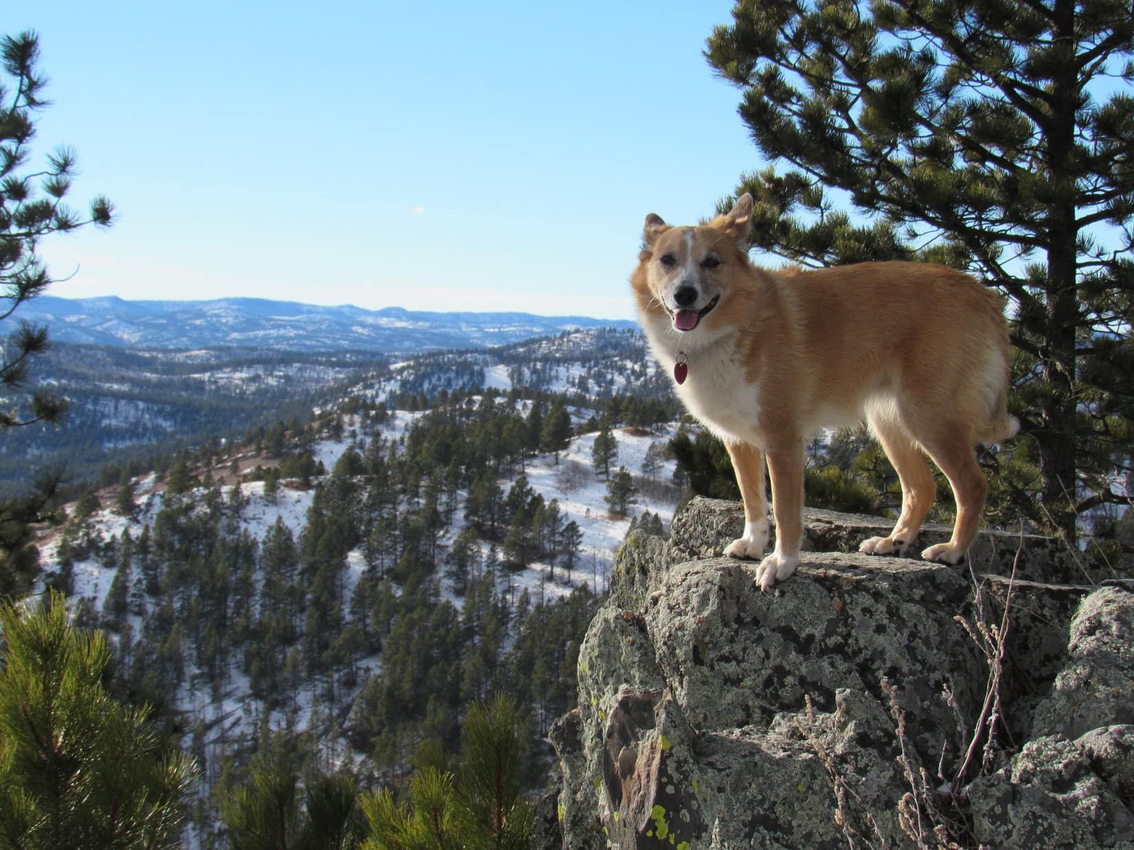
A few more minutes and Lupe was there, standing atop the boulder at the summit of New Year’s Eve Peak(6,046 ft.).
Looper on New Year’s Eve Peak‘s summit boulder. This was her 5th ascent of the mountain. Photo looks WSW.On top of New Year’s Eve Peak. A cairn can be seen behind Lupe. The cairn wasn’t here the first time Lupe climbed the mountain on 12-31-12. She had seen it for the first time on her 1-1-16 ascent. Photo looks N.
The first two times Lupe had climbed New Year’s Eve Peak, the summit area had all been heavily forested. It had been hard to get much more than a glimpse of a view in any direction. New Year’s Eve Peak used to have a shady, dark, gloomy feel to it, an atmosphere which fit in with being here alone at the end of a dying year.
Sometime during 2015, loggers had come. When Lupe had arrived on New Year’s Day 2016, the S end of the summit area and part of the S slope below it had been cleared. Lots of slash and dead logs had been left to stumble around upon. The affected area was relatively small, but the logging created good, open views to the S and SE. Ever since then, the summit has been brighter and cheerier.
Somehow Lupe and SPHP preferred it the old way, yet that didn’t mean there was any reason not to take a look around.
Looking SE from New Year’s Eve Peak. Calumet Ridge(5,601 ft.) (Center) is seen beyond Sheridan Lake. Silver Mountain(5,405 ft.) is on the L, and Boulder Hill(5,331 ft.) on the far L.
A chilly 20 mph W wind was blowing. It had been 40°F when Lupe and SPHP left the G6 this morning. It didn’t feel like the day had warmed up a bit since then. Lupe and SPHP sat huddled together at the W edge of the summit facing the cold wind, pondering the beautiful winter scene, the passage of 2017, and start of 2018.
Looking WSW with some help from the telephoto lens.
Lupe munched on Taste of the Wild. She had been eating snow, and didn’t want any water. SPHP hadn’t brought anything else.
It’s funny what the mind is capable of. Every other time Loop had been here, the mood had been melancholy, especially when she’d been here right on New Year’s Eve. There was something psychologically depressing about watching the sun sink toward the horizon, and the light of day disappear for the last time on a year that had been part of the unknown future not so long ago. A year now rapidly passing away never to be seen or experienced again.
The years when Loop had been here on New Year’s Day instead of right on New Year’s Eve, some of that sadness still lingered. However, it was already being counterbalanced to a degree by the hope, brilliance and excitement of the new year just beginning.
Perhaps it was partially because Lupe was here earlier in the day today than on previous years, while the sun was still relatively high in the sky. As the Carolina Dog and SPHP sat facing the cold wind, it no longer felt possible to truly mourn the passing of 2017. Surprisingly, with only 2% of 2018 now history, the new year no longer seemed quite as completely bright and shiny as it had been a week ago, either. The mind had already made the adjustment and moved on.
It only felt cold. And like Lupe really had arrived late. Not terribly late, but late. It was good to be here, though, together again, on top of New Year’s Eve Peak peering out at the quiet, familiar wintry scene last gazed upon a little more than a year ago. Loopster’s 2018 adventures were now underway. That was a good thing. 2017 had been a fabulous year, and 2018 was still a 98% clean slate with many adventures to come. Her annual pilgrimage to New Year’s Eve Peak complete, Lupe was ready to press on.
Puppy ho! She was right, no sense sitting in the cold wind too long. Lupe returned briefly to the summit boulder.
Loop on New Year’s Eve Peak‘s summit boulder once again. Photo looks N.
Even though this year’s experience wasn’t quite the same, coming here today had been better late than never. Lupe and SPHP bid farewell to New Year’s Eve Peak, promising to return again, hopefully right when New Year’s Eve finally rolled around again many adventures from now. Then Lupe led the way down the mountain’s S slope to retrace her route along the S ridge back to Pistol Point.
On a ledge early on the way down the S slope. Photo looks W.At an opening along New Year’s Eve Peak‘s upper S slope. Photo looks WSW.Lupe reaches the transition point between the S slope and S ridge. Photo looks S.Peak 5800 (Center) from rocks near Pistol Point. Photo looks ESE.
It felt good to be moving again. Lower down the W wind was demoted to a mere breeze. The slanting afternoon sunlight highlighted details of the terrain. Growing shadows added contrast. All the way back to the G6, Lupe ran and played in a beautiful world. 2018 was finally off to a good start! (3:42 PM, 33 °F)
Looking S from the S slopes of High Point 5917.On USFS Road No. 710 taking the traditional route back to the G6. High Point 5917 is on the R. Photo looks W.
Days 6 & 7 of Lupe’s 2017 Dingo Vacation to the Wind River Range, Wyoming & Select Peaks in Montana
The morning after Lupe’s return from her successful 4 day journey to Wind River Peak(13,192 ft.) was a lazy one. The Carolina Dog had certainly earned a rest day! SPHP picked up some fried chicken and a salad at Safeway in Lander. Lupe took a couple of easy walks down by the Middle Popo Agie River across from Lander City Park.
By 11:00 AM, it was plenty hot out. McDonald’s had ice cream cones on sale for 50 cents. Even cheapskate SPHP was willing to spring for that! Lupe got lessons in how to eat an ice cream cone. By watching SPHP’s example, she became quite proficient at it. It turns out Carolina Dogs are naturals at eating ice cream cones!
Enjoying a 50 cent McDonald’s ice cream cone in Lander, Wyoming. Lupe caught onto the whole ice cream cone concept in a flash!
Lupe’s next peakbagging objective, Squaretop Mountain(11,695 ft.), was clear over on the other side of the Wind River Range at the far NW entrance to Green River Lakes. It would take all afternoon to drive over there, so right after the ice cream cones vanished, Lupe and SPHP left Lander and hit the road.
On her grand summer of 2015 Dingo Vacation, Lupe had spent a day reconnoitering Squaretop Mountain. SPHP has an old book called Wind River Trails by Finis Mitchell, who spent most of his life running a fishing camp in the Wind River Range near the Big Sandy entrance. In it, Mitchell describes a route up Squaretop Mountain from the E leaving the Highline Trail near Beaver Park.
Mitchell wrote that his route up Squaretop Mountain was “not difficult”. He had taken scouting groups, and even a 4 year old child up this way once, yet Lupe had arrived at Beaver Park in late August 2015 only to see towering cliffs. The topo map showed 3,500 feet of elevation gain in less than a mile. No doubt Mitchell knew what he was talking about, but Lupe’s reconnaissance left SPHP desiring a more detailed route description than Finis had provided in Wind River Trails.
On the way back to Green River Lakes, Lupe had met Chad, a friendly forest ranger. Did Chad know of a route up Squaretop? Chad said he’d been to the top of Squaretop himself. He said Mitchell’s route was hard to find since some of the landmarks in his route description (burnt areas) had changed. SPHP asked if there wasn’t a feasible route from the W via Porcupine Pass? Chad confirmed there was one, but it was longer, and he didn’t know the details.
Now, almost two years later, Lupe was on her way to Green River Lakes hoping to find that route from Porcupine Pass to Squaretop Mountain! Hopes were high, bolstered by her success in reaching the summit of Wind River Peak.
The last part of the road to Green River Lakes, which used to be rough, was greatly improved. It was still dusty and washboardy, but wasn’t nearly as stony as in 2015. Gophers were abundant, and frequently dashed across the road as the G6 approached. Lupe was enthusiastic about the gophers, and barked frantically at them as she sped by.
Lupe arrived at the trailhead near Lower Green River Lake at 5:00 PM. Loop and SPHP were both anxious to go down to the lake to get a good look at gorgeous Squaretop Mountain again.
Lupe arrives at Lower Green River Lake for the first time in nearly 2 years. Her beautiful peakbagging objective, Squaretop Mountain (Center), is in sight beyond the lake. Photo looks SSE.
Lower Green River Lake and Squaretop Mountain were every bit as lovely as Lupe and SPHP remembered. Of all the mountains in the Wind River Range, Finis Mitchell had chosen Squaretop for the cover of his book Wind River Trails.
Lupe wading in Lower Green River Lake. Photo looks SSE.
Lupe and SPHP both went wading in Lower Green River Lake. The mosquitoes were bad, though, and eventually put an end to the fun. Lupe then went down to the Highline Trail bridge where the Green River exits the lake. A sign said that the bridge over Clear Creek (near the opposite end of Lower Green River Lake) was out due to flooding.
Lupe on the Highline Trail bridge over the Green River close to where it exits Lower Green River Lake. The Green River was running high, and a sign said the bridge over Clear Creek near the opposite end of the lake was out due to flooding. Photo looks NNW.
The Green River was running high, full of water from bank to bank. Having just seen how full the creeks were, and how much snow still existed in the high country near Wind River Peak, Lupe wasn’t surprised. With the bridge over Clear Creek out, Lupe wouldn’t be able to take the Highline Trail (No. 94) to Porcupine Pass tomorrow. Fortunately, an alternate route exists. Lupe could still take the Lakeside Trail (No. 144).
Even though Lower Green River Lake is at 7,961 feet elevation, the evening was hot. The mosquitoes were bad. Lupe and SPHP ended up staying in the G6, periodically running the AC to keep cool. While SPHP caught up the journal, Lupe watched gophers. Every now and then, she just had to be let out to bark at squirrels, or sniff at a gopher hole.
The next morning it was time for action! Lupe and SPHP went down to Lower Green River Lake again to admire Squaretop Mountain(11,695 ft.) before setting out for Porcupine Pass. (8:44 AM, 7-14-17, 66°F).
Lupe at Lower Green River Lake the morning of 7-14-17 ready to set out for Porcupine Pass, and eventually Squaretop Mountain (Center). Photo looks SSE.Squaretop Mountain from Lower Green River Lake, Wind River Range, Wyoming. Photo looks SSE.
After a good look at her magnificent objective, Lupe followed the Lakeside Trail S along the W side of Lower Green River Lake. Despite it’s name, the Lakeside Trail is seldom down by the shore. Most of the time the trail stayed in the forest 50 to 150 feet above the lake. Only once in a while did Lupe come to an opening with a good view of the lake and mountains beyond.
Heading S on the Lakeside Trail on the W side of Lower Green River Lake. Despite its name, most of the time the Lakeside Trail is 50 to 150 feet above the shoreline. Flat Top Mountain(11,823 ft.) is in the distance on the L. Photo looks ESE.
Lupe was less than halfway along Lower Green River Lake, when a backpacker approached from the opposite direction. He turned out to be quite an interesting fellow. Radek Hecsko was 48 years old, and from the Czech Republic. He billed himself as “Czech Mix”.
Lupe meets “Czech Mix” on the Lakeside Trail. Czech Mix was hiking the Continental Divide Trail from Mexico to Canada.
Czech Mix was hiking the entire 3,100 mile Continental Divide Trail from Mexico to Canada! He had started on May 2 in New Mexico, and hoped to reach the Canadian border by mid-September. In 2015, he had previously hiked the entire 2,600 mile Pacific Crest Trail, which also goes all the way from Mexico to Canada.
Czech Mix jokingly called the Continental Divide Trail the “IPA Trail”. He said he typically hikes 30 miles per day, though not in the most rugged territory, and does take occasional rest days. Depending on the kindness of strangers, he hitchhikes to towns whenever possible to resupply. On the trail he often goes hungry, but in towns he packs in the calories feasting on hamburgers, coffee and IPA’s.
Czech Mix said he might eventually take on the 2,190 mile Appalachian Trail to complete the “Triple Crown”, a feat very few people have ever accomplished. He hadn’t really decided yet, though. It was another massive undertaking. For now he was staying concentrated on enjoying and completing the Continental Divide Trail. Completing the CDT would be a rare accomplishment in itself, since it was the longest of the 3 trails and by far the least traveled.
After petting Lupe, and a nice chat with SPHP, Czech Mix pressed on.
Well, that Czech Mix was mighty impressive, Loopster! Can you imagine tackling a 3,000+ mile long trail through high mountains like that? It’s just plain heroic!
Oh, are we gonna do that?
I’ve no doubt you could, Loop, but I’m not up for it. Completing any one of those trails is a gigantic endeavor! I’ll be happy, if we can just make it to Squaretop Mountain.
Oh, I’m sticking with you, SPHP. I’ll be happy if we can find some squirrels!
Flat Top Mountain(11,823 ft.) (L) and White Rock(11,284 ft.) (R) from the Lakeside Trail. Lower Green River Lake in the foreground. Photo looks SE.
Lupe continued meeting people along the Lakeside Trail. They came strung out in small groups, but were all members of a youth group that had been camped at Twin Lakes. The group leaders were all concerned about an 18 year old, who had wandered off on his own and never showed up at camp last night. Their anxiety was only increased by the knowledge that his father was an attorney.
Two miles from where she’d started, Lupe reached the end of Lower Green River Lake. Another 0.25 mile brought her to a trail junction. Loop turned R on the Porcupine Trail (No. 137). She would be gaining elevation nearly all the way to Porcupine Pass, a good 6 or 7 miles away as the trail goes.
Sign at the trail junction S of Lower Green River Lake. Lupe would take the trail to Porcupine Pass.Lupe about to hit the Porcupine Trail seen beyond her. Photo looks S.
The Porcupine Trail didn’t begin climbing immediately, however. For almost another 0.25 mile it remained level until Loop reached Porcupine Creek. No bridge! Another ford. Lovely! Lupe had forded a lot of big streams on her way to Wind River Peak, but SPHP had been hoping for a bridge here. No such luck.
Less than 0.25 mile S of the trail junction, Lupe arrives at Porcupine Creek. SPHP had been hoping for a bridge. No such luck.
Actually, that wasn’t entirely true. Upstream of the ford, a log extended over the creek. A thin cable, which could be easily grabbed for support, was stretched high above it. The log’s circumference wasn’t all that large, however, especially toward the far end. Lupe couldn’t grab the cable, and might easily fall. It was a drop of several feet into Porcupine Creek. This makeshift bridge wasn’t going to do.
The near side of the ford was shallow, slow-moving water. The far side was deeper, and a great volume of water seemed to be racing by. What bothered SPHP far more than the ford itself, however, was what was right below it. Only 20 feet below the ford, Porcupine Creek made a sharp bend. This bend was clogged with sunken logs, branches and other debris. The water was over Lupe’s head. If she got swept downstream, she would be pinned with great force against the debris.
Czech Mix hadn’t come this way. The entire youth group had, however. No one had mentioned any problems crossing Porcupine Creek. SPHP didn’t like the setup, but decided to carry Lupe across.
The bottom where the creek was deepest was stony. Fortunately, perhaps due to traffic on the trail, the stones weren’t very slippery. Porcupine Creek turned out to be only knee deep, but SPHP still had a hard time maintaining balance on the uneven bottom against the force of the swift current. The Carolina Dog was glad to be let gently back down on solid ground again, when SPHP managed to struggle across safely.
The Porcupine Trail now began to climb aggressively, switchbacking SW up a steep forested slope. Partway up, Lupe could hear Porcupine Falls somewhere off in the woods to the N, but she never saw it. After gaining 800 feet of elevation, the trail gradually started leveling off. Eventually Porcupine Creek came back into view.
After gaining more than 800 feet of elevation from the ford, Porcupine Creek came back into view again as the trail leveled out. Photo looks W.
Shortly after leveling out, the trail turned NW and forded Porcupine Creek again. It could be seen continuing up a hillside beyond the far bank. Thinking that was just the way to Twin Lakes, SPHP skipped the turn, and led Lupe SW beyond a trail junction staying on the SE side of Porcupine Creek.
The trail Lupe was on soon disappeared in a bog. SPHP was puzzled when it couldn’t be found again on the other side. Where had it gone? No matter. Lupe and SPHP continued onward, bushwhacking through the forest up hilly terrain.
After more than 0.25 mile, Lupe did find the Porcupine Trail again! Belatedly, SPHP suddenly realized the trail to Twin Lakes hadn’t branched off until the Porcupine Trail had crossed over to the W side of the creek. To stay on the trail, Lupe should have taken the ford that SPHP had her skip.
Oh, well. No harm done. Lupe had managed to bushwhack her way through, and it was actually better this way when the creek was so high. The American Dingo’s bushwhacking had avoided 2 stream fords in the process. Puppy, ho! Onward!
Lupe finds the Porcupine Trail again. Although the day had started out mostly sunny, by now the sky was clouding up. Photo looks SW.
The trail was in great condition where Lupe found it. It headed SW up a huge valley. Porcupine Creek was often in view flowing through wide green meadows. The trail almost always stayed out in the open, but gradually deteriorated, becoming muddy and passing through bogs in some places. Lupe had wonderful views of rugged mountains towering over the far side of the valley.
Porcupine Creek flows down a wide valley of green meadows. Lofty peaks towered above both sides of the valley. Photo looks SW.
More than 0.5 mile from where Lupe had picked up the trail again, Porcupine Creek turned W to go around a small forested hill. This was an especially nice spot, and seemed like a good place to take a break. Lupe left the main trail to follow a short side spur down to the stream. Wildflowers grew in abundance. Lupe laid down for a rest. Mosquitoes were a nuisance for the first time today, but they weren’t too bad.
Lupe pauses for a rest near Porcupine Creek. Photo looks W.Wildflowers were abundant, although bright red ones like these were far less common.
After a pleasant break, Lupe and SPHP continued on. The Porcupine Trail climbed the small forested hill, but soon exited the forest again. For a while the trail was wet and boggy. However, the valley eventually narrowed. The trail became rockier, steeper, and re-entered the forest. Up ahead were mountains with more snow on them than the scattered patches seen up to this point.
Beyond the small forested hill, the trail went back out into the open again. For a while it stayed wet and boggy. Meanwhile, the mountains up ahead were looking snowier. Photo looks S.As the Porcupine Creek valley narrowed, the trail dried out and became rockier. Lupe started gaining elevation more rapidly. Photo looks S.Lower down Porcupine Creek had been a gentle meandering stream, but now it was mostly whitewater as it tumbled over increasingly rocky terrain. Photo looks S.Looking W across the Porcupine Creek valley.
After a long march, the Porcupine Trail finally emerged from the forest again. It approached Porcupine Creek, closely following the E bank. As Lupe continued S, the trail disappeared straight into a huge snowbank. Efforts to pick up the trail on the far side of the snowbank failed. Sigh. What now?
Lupe had been making good progress toward the upper end of the long valley. Ahead was another stretch of forest, but it couldn’t be too much farther to open ground again. There seemed to be no choice, but to resume bushwhacking and see where it led. The American Dingo climbed back into the forest.
The forest was denser here than where Lupe had bushwhacked before. It wasn’t too hard to get around, though. Loopster soon came to two substantial tributaries of Porcupine Creek in quick succession. They were wild, whitewater streams that plunged W down from mountains on the E side of the valley.
Bushwhacking through the forest again, Lupe came to two substantial tributaries of Porcupine Creek in quick succession.
Fortunately neither tributary was so large that Lupe couldn’t find a safe place to ford them in short order. Looper hadn’t gotten too far beyond the second stream when she reached the end of the forest. She started crossing a meadow, and came across the Porcupine Trail yet again.
SPHP didn’t realize it at the time, but the trail had once again crossed over to the W side of Porcupine Creek for a short distance before returning to the E side. So what? Lupe’s bushwhacking had avoided another 2 fordings. She was close to the end of the valley now. Porcupine Pass was less than a mile away! The trail went SE, heading straight for it.
Back on the Porcupine Trail again. Lupe is getting close to Porcupine Pass (Center), now less than a mile away. Photo looks SE.
The trail became progressively steeper and steeper. Soon Lupe was on switchbacks. The forest began to thin out. The trees became stunted. When Lupe reached treeline, Porcupine Pass was in view. It was nothing like SPHP expected.
Porcupine Pass is at 10,700 feet elevation. Yet due solely to its name, SPHP had always thought of it as being forested. Thought of it as a place one might find porcupines – not that finding a porcupine was a good idea. An encounter with one might end very badly for Lupe.
No worries, though, on that score! Only scattered trees remained in view ahead. None at all were up on the high saddle which appeared to be Porcupine Pass. Lupe was still hundreds of feet below the pass. A very long, steep snowbank led up to the top. Egads!
Above tree line, Lupe’s first really good look at Porcupine Pass (L) was nothing like SPHP expected. Photo looks S.
Lupe continued up the trail, now hidden beneath snow, until she got close to the steep final slope leading up to Porcupine Pass. Here she left the trail, and traveled E climbing a rocky hill. She got up high enough for a good look around at the terrain in most directions.
Still hundreds of feet below Porcupine Pass, but not far from it, Lupe had this grand view of the Porcupine Creek valley she had just traveled up. Photo looks NNW.Looking W. The Jim Creek Trail, which Lupe had bypassed while bushwhacking, is somewhere on the green slope on the opposite side of the valley.
The view to the E was the critical one. It was decision time. SPHP had originally planned for Lupe to go all the way on up to Porcupine Pass. From there she would head E tomorrow for New Benchmark(11,850 ft.) and Peak11,820 on her way to Squaretop Mountain(11,625 ft.).
However, an alternate route skipping New Benchmark entirely might be possible by continuing E from here without ever going all the way up to Porcupine Pass. The topo map seemed to suggest this might be an easier route.
SPHP hesitated. The view to the E was not all that reassuring. Going E didn’t look clearly possible or impossible for Lupe. There was a lot of rough, rocky ground. Half a mile away or more was a wall of rock. From here, SPHP couldn’t see enough detail to tell for certain if Loop might be able to skirt it to the S, or not.
Looking E from below Porcupine Pass. Lupe could skip Porcupine Pass and New Benchmark going this way, but it looked like a lot of rough terrain. Could she even get past the wall of rock seen on the N (L) bypassing it to the S (R)?Another look E with more help from the telephoto lens.
A significantly longer, but perhaps less rugged option was also in sight to the NE. That route all depended on whether Lupe could manage to get up on a big ridge at the end of a valley. She probably could, but she’d have to travel quite a distance to find out for sure.
Another alternate route was in sight. Maybe Lupe could travel up the distant upper valley seen L of Center and climb up on the big ridge at the end? Once on the ridge, she could head SE bypassing both New Benchmark and Peak 11820. That might work, but certainly seemed to be the long way around. Photo looks NE.
Maybe all of the routes would work? Maybe none of them would. The decision on which way to go was an important one, perhaps critical if Lupe was going to have any success in reaching Squaretop Mountain. Yet the right thing to do wasn’t at all clear. Lupe could only try one approach. SPHP wasn’t carrying enough supplies for any more than that.
Only short sections of the trail switchbacking 400 feet up the steep slope to Porcupine Pass were visible. The vast majority of the trail was buried beneath a long steep snowfield. However, a lane of snow-free ground existed E of the trail. It was very steep, but Lupe could climb that slope easily enough. SPHP could probably manage it, too.
In the end, SPHP decided to stick with the original plan. Lupe began the climb up to Porcupine Pass.
Lupe on the final steep slope leading to Porcupine Pass. Photo looks S. And up!
It was a good thing the slope wasn’t any steeper, or SPHP wouldn’t have made it. There were places where there was nothing firm to hang onto. Traction wasn’t always good. Yet it wasn’t long before Loop and SPHP were safely up at Porcupine Pass. The views were impressive!
Loop arrives at Porcupine Pass! She had an impressive view of the long Porcupine Creek valley (R) she had traveled up to get here. Photo looks NNW.The Dodge Creek valley from Porcupine Pass. Photo looks SSE.
Porcupine Pass was beautiful, but barren. It felt cold, remote and forlorn. Lupe hadn’t seen anyone since leaving the Lakeside Trail many miles ago. It had been a long day. For hours during the afternoon there had been dark clouds off to the NW, but now that it was evening, the sky had partially cleared. There were still clouds around, but they didn’t look threatening.
Congratulations, Loopster! This is it. Porcupine Pass. You made it!
We’re staying here?
Yeah, for tonight. I’ll set up your tiny house in a minute. Want to climb that hill to the W for a look around, once it’s up? It’s Porcupine Pass Peak(10,890 ft.). Won’t take long.
Can we do it in the morning, SPHP? I’m hungry, and ready for a snooze. Mosquitoes are bugging me even up here. I’d sort of like to get in the tiny house, and call it a day.
Sure, we can do that. I’d wish for a breeze to blow the bloodsuckers away, but its probably not a good idea.
Why not?
I have a feeling Porcupine Pass would be an absolute hurricane if the wind came up. We’re lucky it’s a calm evening, even if we have to put up with some bad bugs. Anyway, you’re right. Tomorrow’s our big push for Squaretop Mountain. We may as well eat and rest up for it as much as possible. Just getting to New Benchmark(11,850 ft.) might be an ordeal, and Squaretop is miles beyond it.
Are we going to have problems?
Dunno. Maybe. New Benchmark looks far more challenging than I’d expected. However, once we’re beyond it, you’ll have gained all the elevation you need to, and the terrain ought to be a lot easier. It better be, if we’re ever going to make it to Squaretop. We’ll see, though. One thing is for certain, tomorrow will be another long day.
Whatever. What’s for dinner?
For you, Alpo and Cliff bar.
Oh, that doesn’t sound bad at all! Hurry up and get the tiny house assembled, would you? I’m famished!
On it!
Lupe at Porcupine Pass, with her fully assembled tiny house in the background. Photo looks SSE.View to the E toward New Benchmark (R) from Porcupine Pass. Tomorrow Lupe would have to go over New Benchmark and miles beyond it, if she hoped to get to Squaretop Mountain.
Christmas had come and gone. The year was almost shot, but Lupe had a final chance for adventure in 2017. Xochitl, Steve and baby Felix were flying into the Denver area from Chicago for a couple of days. They would be staying at Matt, Cassie and baby Owen’s home in Parker. Lupe and SPHP had an invitation from Joe and Andrea to come and stay in the Cowboy room at cousin Dusty’s home in Arvada.
Adventures with babies? That was something new, and a rare opportunity! Babies have a way of changing fast, and not being babies any more. SPHP told Lupe that even though it would be a quick trip, there might be time for an outdoor adventure or two as well. Even if Loop wasn’t certain about how adventures with babies might turn out, the year was going to end with bitterly cold subzero weather in the Black Hills. Nothing was going to happen these last few days here at home. So, did Loopster want to go to Colorado?
Cousin Dusty comes to visit the Black Hills every so often, so Lupe’s ears pricked up at the mention of Dusty’s name. Loop hadn’t been to Colorado, though, for a very long time – not since November, 2015. She could scarcely remember the Cowboy room at Dusty’s house, other than a vague sense that it had been a great place to stay. There hadn’t been any babies around back then, but Lupe had climbed a couple of choice Colorado county high points. That had been fun!
Babies in Colorado, with the possibility of an outdoor adventure or two? Or stay home and spend the rest of the year laying on the living room rug staring bored-to-tears out the window at a subzero polar display? Hah! Lupe knew the answer to that one!
The novel adventure began on the frosty morning of 12-28-17 (6:58 AM, 16°F) when Lupe left home in the G6 comfortably riding shotgun atop her usual pile of pillows and blankets. A Dingo Vacation in the winter was something completely unheard of up until now. Lupe had great expectations!
At first those expectations were disappointed. Hwy 471 S of Edgemont was snow-packed and slippery. The day hadn’t warmed up a bit. SPHP cancelled two possible short peakbagging breaks in the Nebraska panhandle, deciding to stay on main Hwy 18 which was clear to Mule Creek Junction in Wyoming. No consideration was given to any other significant breaks the rest of the way.
Lupe arrived at cousin Dusty’s house in Arvada before mid-afternoon (2:06 PM, 39°F). Dusty and Andrea were both home and answered the door. Lupe dashed right in all excited to see them! After the initial excitement, Loop sniffed around for a few minutes. Yes, it was all coming back to her now. The Carolina Dog did remember this place!
A lot of pent-up canine energy needed to be released. Dusty, Andrea, Lupe and SPHP set out on a favorite walk around the 100 acre field out in back of Dusty’s house.
Andrea, Dusty & Lupe in the 100 acre field behind Dusty’s house. Photo looks W.Cousin Dusty was sure surprised when Lupe showed up!
Cousin Dusty loves to fetch sticks. The bigger the stick, the better. She ran ahead of Andrea and SPHP looking for sticks to drop in their path, hoping to entice them to throw them for her. Dusty would then zoom away after the stick, often catching it on the first bounce after a good throw.
Dusty waits for Andrea or SPHP to toss the stick she has carefully positioned out in front of her. Photo looks N.
Lupe never shows the slightest interest in chasing Dusty’s sticks. Instead, she loves to act as defense on the stick’s behalf. As soon as the stick gets tossed, she focuses entirely on barking and trying to herd Dusty. While Lupe ignores the stick, Dusty ignores Lupe. It’s a game they rarely tire of.
Dusty awaits the tossing of the stick, while Lupe awaits the opportunity to herd Dusty.
When the journey around the 100 acre field was over, Lupe was quick to reclaim the Cowboy room back at Dusty’s house. Even though they like to spend time in the wilderness, American Dingoes are big fans of luxury, too!
Lupe was quick to claim her spot in the Cowboy room at Dusty’s house, where she would stay the next 3 nights. American Dingoes love luxury in addition to the outdoors!
As sunset approached, Lupe, Dusty and SPHP took one more trip around the 100 acre field. There was more Dingo excitement when Joe came home after work. After dinner, Joe, Dusty, Lupe and SPHP went on a long evening walk on the bike path near Ralston Creek. Lupe went all the way past Jungle and Utah bridges.
The next day, Joe and Andrea had to work. Dusty and Lupe went on dawn patrol with SPHP around the 100 acre field to get the day off to a good start. Lupe and SPHP then drove down to Matt, Cassie and Owen’s house in Parker, arriving late in the morning.
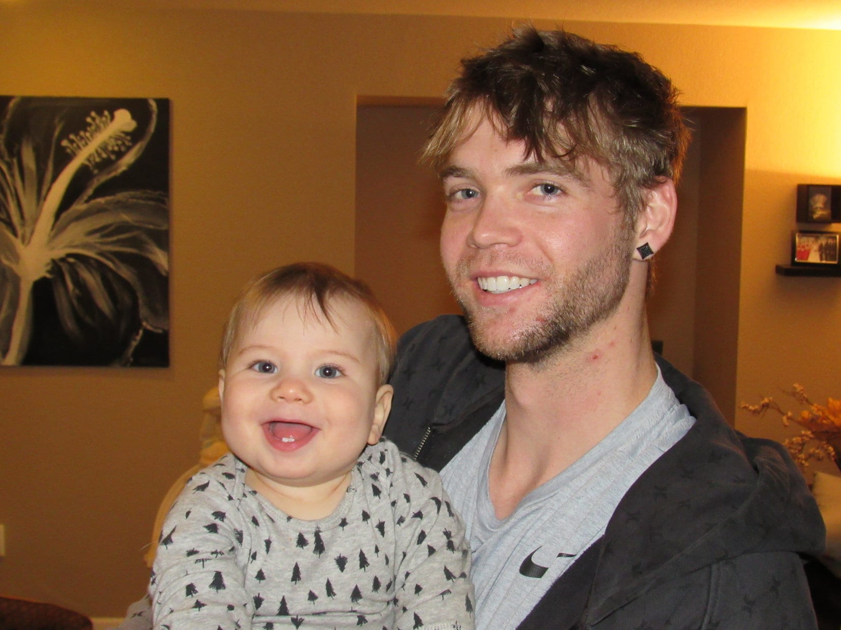
Babies Owen (6 months) and Felix (9 months) were up looking bright-eyed and happy, but the adults were about shot. The plane Steve, Xochitl and Felix had taken last evening had been hours late, arriving in Denver after midnight. Felix had then proceeded to cry and scream until 3:30 AM. A bleary-eyed Xochitl was up, and so was Matt. Matt was probably exhausted, too, but he is always so calm natured, it was hard to tell. Cassie and Steve were both asleep.
Lupe with Felix. Lupe isn’t used to being around children much, especially infants. She sometimes eyed Felix suspiciously as he crawled toward her. Perhaps it was because Felix liked to whack her face, his way of petting her.
The afternoon was spent watching, feeding, and playing with Felix and Owen. Lupe also played with Matt and Cassie’s dog, Maya. She went on a neighborhood walk with Matt, Maya and SPHP. Cassie eventually appeared, long before Steve finally regained consciousness at 3:45 PM. By then, Felix was taking a nap.
Steve, Xochitl, Matt, Cassie and Owen all went out for sushi around dinnertime. Lupe and SPHP stayed at the house with Felix. Felix is known for not sleeping much, so he was expected to wake up at any moment. Instead he was still snoozing when everyone returned from the restaurant at 9 PM. Lupe and SPHP then headed back to the Cowboy room at Dusty’s house in Arvada.
Saturday morning was Lupe’s one chance on this short Dingo Vacation for an adventure in the Colorado front range foothills. Joe, Dusty, Lupe and SPHP headed for the lower E trailhead at White Ranch Park, which was only 10 minutes from Dusty’s house.
Joe, Dusty & Lupe about to set out on the Belcher Hill trail from the lower E trailhead at White Ranch Park.
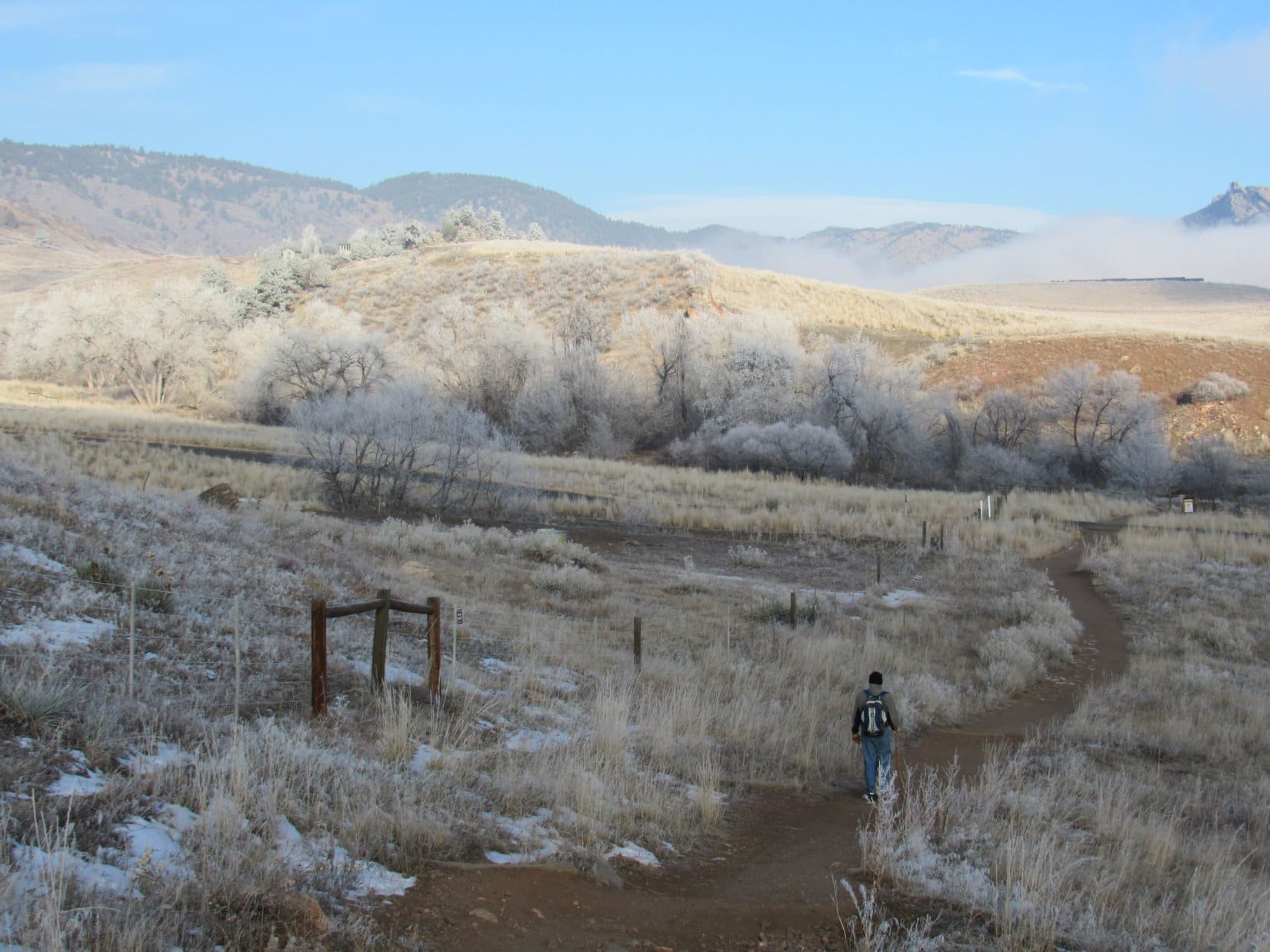
It was a chilly 14°F when Lupe and her pack set out on the Belcher Hill trail. The trees and fields were frosty, wisps of fog and low clouds hung in the air, but the sky overhead was blue. The trail lost a bit of elevation on the way N to a low spot, then started climbing gradually as it followed the dry Van Bibber creek drainage NW.
Joe leads the way on the brief initial drop down to Van Bibber creek (where the frosty trees are). The creekbed was dry down here, but contained a little flowing water higher up. Photo looks NNW.Joe, Dusty & Lupe near the start of the climb. Photo looks NW.
The Belcher Hill trail starts out on an easement across private property that leads to the rest of White Ranch Park. At first there were homes not far from the trail. It wasn’t long before Lupe had gained enough elevation to be looking down on several Colorado shacks.
As shacks go, they were really quite nice. No doubt one can be had for only a few million dollars. Lupe liked the looks of them, and asked SPHP’s opinion. SPHP liked them too, but sadly checked pocket change and came up rather short.
Looking down on several Colorado foothills shacks from the Belcher Hill trail. Photo looks NNE.
After 1.1 mile, Lupe reached a junction with the Whippletree trail. She stayed on the Belcher Hill trail, which turned SW here. By now it was clear that a huge expanse of cold air E of the foothills was capped with a layer of low clouds. The city of Denver and all its surrounding suburbs were hidden from view. Lupe could see the top of North Table Mountain(6,570 ft.) off to the SE floating barely above the clouds.
The flat top of North Table Mountain could be seen floating like an island above low clouds. Photo looks SE.Joe and Dusty on the Belcher Hill trail a little beyond the junction with the Whippletree trail. Photo looks NE.
Shortly after bypassing the Whippletree trail, the effects of a powerful inversion became evident. The temperature started changing rapidly, sometimes quite noticeably within only a few feet. Overall it was getting a lot warmer out, but Lupe came to pockets of cold air, too.
Joe, Dusty & Lupe nearing the end of the Belcher Hill trail portion of the hike. It was already a lot warmer out, mostly due to a powerful inversion. Joe & SPHP were soon shedding layers. Photo looks SW.
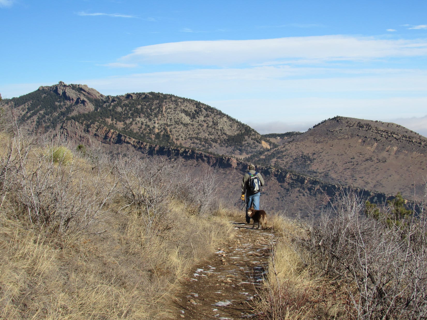
The Belcher Hill trail steepened, and made a switchback shortly before coming to another junction, this time with the Longhorn Trail.
North Table Mountain again from the Belcher Hill Trail. The low clouds were just starting to clear out, moving slowly off to the E. Photo looks SE.Lupe still along the Belcher Hill trail. She had started out near the frosty trees seen way down in the valley below. Photo looks SE.Joe and Dusty pause for a look around near the end of the Belcher Hill trail section of the hike. Photo looks W.
At an intersection 1.8 miles from the E trailhead where Lupe had started, Joe and Dusty led the way onto the Longhorn Trail.
Lupe at the intersection of the Belcher Hill and Longhorn trails 1.8 miles from the trailhead. Joe & Dusty are already leading the way on the Longhorn Trail. Photo looks NE.As clouds moved off to the E, it became possible to get a good look at Ralston Reservoir (R). Photo looks NE from the Longhorn Trail.Ralston Reservoir (L) from rocks near the Longhorn Trail. Photo looks NE.Another look at Ralston Reservoir from some different rocks. Photo looks NE.
After a short steep section, the Longhorn trail leveled out and became more of an up and down affair as it headed N. After 0.4 mile, a junction with the Shorthorn trail was reached. A longer loop could be made by taking the Shorthorn trail. It was such a nice warm day this high up due to the temperature inversion, longer was definitely the better choice. Everyone hit the Shorthorn trail.
The Shorthorn trail gained a bit more elevation, but only gradually with both up and down stretches along the way. At first it headed NW. This was a unique part of the hike, because the trail went through a shady forest of large pines. Later on the trail turned NE, and wound around a series of ravines on much more exposed sunny slopes.
Joe and Dusty on the Shorthorn trail. Photo looks NE.Dusty on the Shorthorn trail. Photo looks E.Cousin Dusty again. North Table Mountain is seen on the R, still partially hidden by clouds. Photo looks SE.North Table Mountain from the Shorthorn trail in White Ranch Park. Photo looks SE.
A 1.1 mile trek on the Shorthorn trail led to a different point on the Longhorn trail. Shortly after reaching this junction, Joe discovered he had forgotten his walking stick about 0.33 mile back while shedding layers due to the near 60°F temperatures. Everyone doubled back to retrieve it.
Joe, Dusty & Lupe near a second junction of the Shorthorn & Longhorn trails. Photo looks SE.Heading back on the Shorthorn trail to retrieve Joe’s walking stick. Photo looks SW.
The walking stick successfully retrieved, it was back to the second junction of the Shorthorn and Longhorn trails. A short hike up the Longhorn trail led to a tiny creek in a ravine. At a big rock beside the little stream, it was time for a break. Lupe and Dusty shared some Taste of the Wild. Joe and SPHP had apples. Dusty enjoyed polishing off the apple cores.
At the break rock near the tiny stream along the Longhorn trail.
After the break, it was time to head back down to the trailhead. Joe and Dusty lead the way, using the Longhorn and Whippletree trails to complete a loop back to the Belcher Hill trail. By the time Lupe arrived back at the trailhead, the air had warmed up some down here, but it was still only 30°F compared to near 60°F higher up.
Joe and Dusty lead the way down the Longhorn Trail on the way back to the trailhead.
The White Ranch Park adventure was over, but more good things were about to happen! Joe, Andrea, Dusty, Lupe and SPHP were soon on the way back to Matt and Cassie’s house in Parker. It was time for more fun with babies! Owen was the only baby there at first. Steve and Xochitl had taken Felix with them to visit friends. Felix hadn’t woken up until 7 AM this morning, a recent personal record of 16 consecutive hours of sleep!
Knowing that SPHP was certain to sneak her some, Lupe was especially pleased at the news that Matt was going to smoke a huge chicken and ribs this afternoon!
Oh, boy! Smoked chicken and ribs! Let’s make this a tradition after every adventure! Whad’ya say SPHP?Andrea with momentarily camera shy baby Owen.
Lupe had fun with Maya. Eventually Steve, Xochitl and Felix showed up. Mark did, too. SPHP built towers with Owen’s blocks. Felix had a good time knocking them down.
Lupe kept wanting to wrestle with Maya. Maya did a little bit, but finally retreated to her doggie bed for a respite from the over-active Dingo.Felix eventually showed up at Matt & Cassie’s. Felix liked knocking down towers of blocks that SPHP built for that very purpose.Adventures with baby Felix!
The big chicken and ribs took a long time to smoke. Steve, Dusty, Maya, Lupe and SPHP took a walk at dusk. Upon return, the smoked chicken and ribs were nearly ready. The feast was soon served. The smoked chicken and ribs were delicious! Everyone had a great time! A certain sly Dingo feasted on both chicken and ribs.
Felix & Mark.Steve, Xochitl, Mark & Felix.
All too soon, it was time to head back to the Cowboy room in Arvada with Joe, Andrea and Dusty. The next morning, Lupe left Dusty’s house after one last spin around the 100 acre field with Joe, Dusty and SPHP. The trip to Arvada and Parker, Colorado had been a quick one, but a fun time!
By the time the sun set for the last time in 2017, Lupe was back in her Black Hills of South Dakota. The G6 said it was 5 below zero when Lupe finally got home. 2018 was destined to get off to a frigid start.
In Wyoming on the way home on the last day of 2017. Photo looks W with the Laramie Range (R) seen faintly on the far horizon.Looking S at I-25 from the rest stop near Orin, WY as 2017 draws to a close.