Day 1 of Lupe’s 2017 Dingo Vacation to the Laramie Range, Wyoming & Beyond
Nine months gone. Practically an eternity! Late in the evening, Lupe laid sad-faced and bored on the even sadder-looking old couch clawed up by 4 cats who no longer lived here. Did she ever even think anymore about those glorious days of her last and greatest 2016 Dingo Vacation when she’d gone all the way to the Canadian Rockies, Yukon & Alaska?
If so, you couldn’t tell it. Of course, maybe she was thinking of those times, and how long ago and far away it all seemed was what was making her sad. Loopster heaved a sigh, staring vacantly over the edge of the couch. She looked like she had lost her last friend.
Forlorn Lupe.
She hadn’t, of course. She’d been on lots of Black Hills expeditions full of adventures with SPHP over the last nine months. Fun times, but not the same as hitting the open road for days on end spent exploring exciting, beautiful, distant lands.
While Loop moped on the couch, SPHP was not idle. A warm, fragrant breeze stirred the air. Late spring by the calendar. Early summer by SPHP’s reckoning.
Better enjoy lounging around like that while you still can!
Lupe’s eyes shifted to watch SPHP busily checking equipment and supplies. Her expression didn’t change.
You’ll see, soon enough!
Promises, promises. Nothing fun happened. Dullsville.
The next morning SPHP was up early. Shower, breakfast, and then back and forth packing all this stuff into the G6. Lupe began to realize something really was up. A glimmer of hope in her eyes grew rapidly to increasing anticipation.
Mountain climbing season, Loopster! It’s here! You ready?
Was she ever! Only a few hours later, Lupe was in Wyoming, whizzing along in the G6 headed for her first adventure of her first Dingo Vacation of 2017. Had the mood ever changed from last night! Looper was ready to let the good times roll!
Lupe returns to the great state of Wyoming at the start of her first Dingo Vacation of 2017. Oh yeah, this is gonna be good!
Lupe was headed for the Laramie Mountains in SE Wyoming. Only 8 days into June, it was still weeks early to head up into some of the higher Wyoming ranges for mountain climbing, since there would still be too much snow on the peaks. However, with the exception of Laramie Peak(10,272 ft.), the highest mountains of the Laramie Range top out only a little over 9,000 ft. There might still be some snow around in early June, but not enough to be a problem.
By early afternoon, Lupe reached Douglas, Wyoming. SPHP drove S from there on Hwy 94. The highway eventually turned to gravel and became County Road No. 5. A mile N of Esterbrook, SPHP had planned to let Lupe tag Prairie Dog Hill(6,400 ft.) as her first peak “climbed” in the Laramie Range this year. It wasn’t even really a climb at all, since County Road No. 5 goes almost right over the high point. Pathetically easy.
However, when Lupe arrived at Prairie Dog Hill, a cattle drive was in progress right on the road. Lupe was almost out of her mind with delight! She bounded from window to window of the G6 in a foaming-at-the-mouth barking frenzy. She was eager to get out and help drive some cattle herself! Not such a good idea. The cowboys might have an issue with that. SPHP drove on, turning E at Esterbrook on USFS Road No. 633.
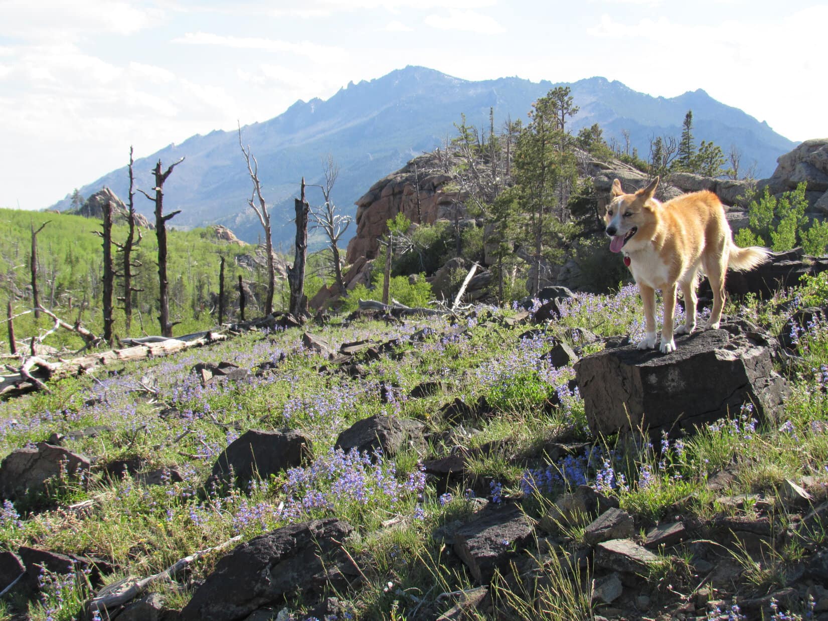
No. 633 wound N & E for several miles. Shortly after passing Esterbrook Campground, the road began to lose elevation and turned S. Lupe’s first real peakbagging objective, Black Mountain(7,960 ft.), came into view.
Black Mountain (L) comes into view from USFS Road No. 633. Laramie Peak, the highest mountain of the Laramie Range is seen in the distance on the R. Photo looks SSW.Black Mountain (Center) was Lupe’s first real peakbagging goal of her 2017 Dingo Vacation to the Laramie Range & Beyond. Photo looks SSW.
Black Mountain was still 9 or 10 miles SSW from where it first came into view. On the way there, Lupe stopped by Horseshoe Creek, which flowed right along USFS Road No. 633 for a couple of miles.
Lupe stops by scenic Horseshoe Creek on the way to Black Mountain. She would later spend the night at the pullout off USFS Road No. 633 seen beyond her.
Looking for USFS Road No. 667, SPHP turned off No. 633 at Camp Laramie Peak, a Boy Scout camp at Harris Park. Lupe and SPHP made inquiry at the main office on how to find No. 667 to Black Mountain.
Lupe stopped at Camp Laramie Peak to inquire about how to find USFS Road No. 667 to Black Mountain. She was a good deal more enthusiastic about how this day was going than the boy outside the Boy Scout camp’s main office.
Camp Laramie Peak was just opening up for the summer season. Councilors were already here, but the first Boy Scouts were just beginning to arrive. Fortunately, an official was available who told SPHP that USFS Road No. 667 (unmarked) to Laramie Peak went right through the camp. He pointed out a road that went S down a little hill.
The road would quickly deteriorate to a high-clearance proposition – it wasn’t going to be G6 friendly at all. This was known in advance from the topo map where No. 667 was marked 4WD. The intention all along had been to ditch the G6 somewhere, and follow the road on paw and foot. Fortunately, SPHP was free to park the G6 at Camp Laramie Peak at a small parking area near the main office.
It turned out that USFS Road No. 667 (a 4WD road) to Black Mountain goes right through Camp Laramie Peak. The officials at the camp said SPHP was free to park the G6 at a small lot not far from the main office, so Lupe’s trek up Black Mountain started right here.
At 3:08 PM (79°F), Lupe and SPHP set off. There had been one caveat mentioned at the office about taking USFS Road No. 667. The road went through Boy Scout property for the first half mile or so. Leaving the road was not permitted. No trespassing on Boy Scout land! Seemed like an odd demand from an organization dedicated in part to promoting the outdoors, but another official reiterated this rule as Lupe and SPHP ambled along the road through the camp.
Whatever, no problem. SPHP adhered rigidly to this restriction. The American Dingo, having spent most of the day cooped up in the G6, was somewhat less diligent. Lupe had a fun time roaming and exploring the forest not too far from the road.
After dipping down through camp, No. 667 crossed a small stream and then began to wind W climbing steadily. Bluebells were growing in profusion in the forests and fields. It was a pretty day, a bit warm, and Lupe was off to a good start. She was beyond forbidden Boy Scout territory in a jiffy. A mile from camp, she arrived at a minor saddle near large rock formations.
Loopster among the bluebells.
About a mile from Camp Laramie Peak, Lupe reached these large rock formations at a minor saddle. Photo looks NNE.
Still hidden from view more than a mile N of the minor saddle was Peak7320, another mountain SPHP hoped Lupe would get a chance to climb. First things first, though! The road turned due S from the saddle and climbed more steeply than before. Lupe followed it, continuing toward Black Mountain.
No. 667 soon turned SW and leveled out for a little way. Peak 7320 now came into view back to the N. The mountain was capped by a huge knob of solid rock. Lupe might not be able to get to the top, even if there was time enough later on for an attempt.
Peak7320 from USFS Road No. 667 on the way to Black Mountain. Photo looks N.
Off to the SW, the summit of Black Mountain had come into view, too. It was a little hard to recognize at first, but got easier to discern as Lupe continued along the road. A fire lookout tower was perched way up on the highest rocks.
The summit of Black Mountain (far L) came into view here, but it was still so far off, it was hard to recognize at first. Photo looks SW.Getting closer! The fire lookout tower on the summit (Center) is now discernable. Photo looks SW.The fire lookout tower at the summit (R of Center) with help from the telephoto lens. Photo looks SW.
No. 667 soon began to climb again fairly steeply. Before long, it made one big jog to the NW before turning sharply S. Once it made the turn, the road started leveling out. Lupe was still gaining elevation, but at an easy pace. The Carolina Dog now enjoyed a pleasant journey S to the summit along the big N ridge.
The views were increasingly beautiful! Albany Peak(7720 ft.) could be seen to the SSE. A little farther on, Laramie Peak(10,272 ft.) came into view to the SW.
Albany Peak is seen straight up from Lupe on the L. Photo looks SE.Laramie Peak, the highest mountain of the entire Laramie Range, comes into view. Photo looks SW.Lupe traveling the big N ridge. The summit is in view, still a little way off. Photo looks S.
Lupe continued S along No. 667 until it curled around a big rock formation, and suddenly ended at the base of the massive stone knob the fire lookout station was perched on. A steep metal stairway was the only way up.
Lupe arrives at the end of USFS Road No. 667. She did not like the steep stairway leading to the fire lookout station. Photo looks ESE.
The American Dingo didn’t like the look of those stairs! She stayed at the bottom, while SPHP climbed the first longest section. SPHP had to plead with her to follow. She finally did come up, but not until SPHP was about ready to go down and get her.
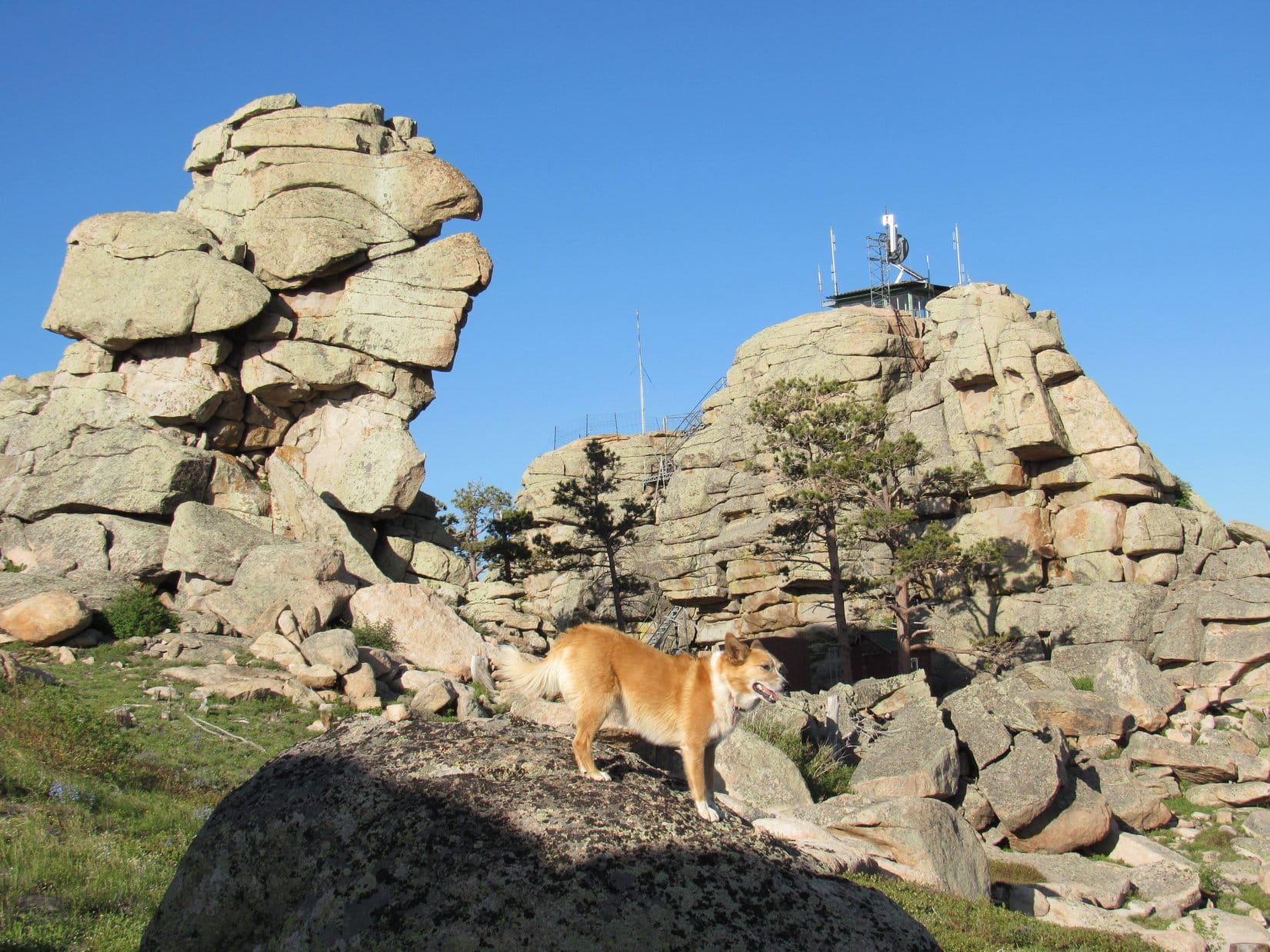
A metal platform turned 90°, and led in a few feet to a 2nd shorter flight of stairs. SPHP climbed this 2nd set, only to turn around and see Lupe running back down the 1st flight all the way to the bottom again. SPHP returned to the top of the 1st flight to resume pleading and coaxing. Looper finally relented. This time she made it all the way to the fire lookout station to claim her peakbagging success!
Despite the long, scary metal stairway, Lupe makes it to the fire lookout station on Black Mountain(7,960 ft.) to claim her peakbagging success! Photo looks S.
The day had been warm and the air calm all the way up the mountain. Even down at the base of the metal stairway, there hadn’t been much of a breeze. However, up at the fire lookout tower, it was considerably cooler. An annoyingly strong gusty wind was blowing out of the SSE. The last bit of elevation gain had made a surprising difference!
It was so windy, Loopster wanted to take shelter in the lookout tower. She was most disappointed that it was padlocked shut, and no one was around to let her in. The views were splendid in every direction. Somewhat reluctantly, the Carolina Dog cooperated with taking photos. She preferred to spend her time on the N side of the tower out of the wind.
Lupe and SPHP made several forays around the tower to check out the views, returning frequently to the N side for breaks from the wind.
Of course, the most impressive view from Black Mountain was toward Laramie Peak(10,272 ft.), the highest mountain in the entire Laramie Range. Photo looks SW with help from the telephoto lens.Looper checks out the view of Laramie Peak. Photo looks SSW.The view to the N.Another look to the N.Albany Peak(7,720 ft.) (L) from Black Mountain. County Road No. 71 down in the Cottonwood Creek valley is seen in the foreground. Photo looks SSE.Another look at Albany Peak a little later on with help from the telephoto lens. Photo looks SE.Haystack Peaks are seen in the foreground on the R. Beyond them in the distance is Bear Head Mountain (8,359 ft.). Photo looks SSW.Another look SSW, this time with more help from the telephoto lens. Haystack Peaks are in the foreground. Bear Head Mountain in the distance.Laramie Peak (R) dominates Haystack Peaks (L foreground) and Bear Head Mountain (L distant). Photo looks SW.The view to the NW. USFS Road No. 667 is seen below.
Lupe spent a good 30 minutes up at the summit of Black Mountain(7,960 ft.). Before leaving, the Carolina Dog and SPHP took a longer break out of the wind on the N side of the lookout tower. Lupe had water and Taste of the Wild. Then it was time for one last look at Laramie Peak from the top, and a final stroll around the lookout tower.
A last look at Laramie Peak from the Black Mountain fire lookout tower. Photo looks SW.After half an hour up at the windy fire lookout tower on Black Mountain, Lupe waits on the sheltered N side of it for the signal from SPHP that it’s OK to start down and get out of the wind once and for all. Photo looks S.
In her eagerness to get out of the wind, Lupe showed no fear of the long metal stairway leading down to USFS Road No. 667. She raced to the bottom in nothing flat. It was still a little breezy back down at the road, but nothing compared to the gusty wind up at the tower.
SW of the lookout tower were some great viewpoints where Laramie Peak was on display. Lupe took a little time to sniff around and explore this area.
Laramie Peak from SW of the lookout tower. Photo looks SW.Looking NE back up at the fire lookout tower.
When Lupe was satisfied with her explorations of the summit area, she headed back N along USFS Road No. 667. She would retrace her route up following the road all the way back to Camp Laramie Peak.
Bluebells on the way back.
Although SPHP had hoped Lupe would have time to take a crack at Peak 7320 on the way down, the sun was starting to get low. Since it looked like there wouldn’t be sufficient daylight to summit and get back to the road before dark, Lupe never made the attempt.
Peak 7320 (Center) seen a little before sunset on the way down Black Mountain. Unfortunately, Lupe wouldn’t have enough daylight to climb it and find her way back to the road before dark. Photo looks N.
It was 9:11 PM (52 °F) when Lupe reached Camp Laramie Peak again. In fading light, she was treated to a ride S in the G6 down the Cottonwood Creek valley on County Road No. 71. SPHP wanted to check out potential access routes to Albany Peak. Maybe Lupe could climb it tomorrow?
There proved to be numerous homes on private property along County Road No. 71. “No Trespassing” signs were posted all over the place. SPHP found one possible access point, but it wasn’t clear if this route went across private property or not. From Black Mountain, Lupe had seen a very large rock formation at the top of Albany Peak. Maybe she couldn’t even get to the top of the mountain, even if there was access?
Reluctantly, SPHP decided Lupe should skip Albany Peak, at least on this trip. SPHP drove N again, as Lupe barked enthusiastically at antelope grazing in the fields at dusk. It was dark by the time Lupe stopped at a pullout along USFS Road No. 633 near Horseshoe Creek for the night.
Sunset in the Laramie Range of Wyoming.
Only 24 hours ago, Lupe had been bored and despondent on the tattered old couch back home. Yet today she’d had a blast traveling to Wyoming and climbing Black Mountain. The lucky American Dingo’s summer of 2017 adventures had only just begun!
Day 15 of Lupe’s 2017 Dingo Vacation to the Wind River Range, Wyoming & Select Peaks in Montana
Dawn. Lupe sat bright-eyed on SPHP’s lap listening to Morning Dew by the Grateful Dead. She gazed intently out the window of Jobe’s silver Jeep Rubicon. Jobe was expounding on Jerry Garcia’s musical talents as he drove. Lupe listened politely as Jobe & SPHP chatted. In truth, she was more interested in the possibility of seeing cows, deer, or squirrels along the 4WD road.
The sun was above the horizon by the time Jobe parked his Rubicon at a 6,900 foot elevation saddle on Crazy Peak’s SE ridge. An old pickup truck was already parked nearby, but no one was around. Good. This was it! Lupe’s big chance to climb Crazy Peak(11,209 ft.) with Jobe had arrived! Crazy Peak wasn’t just any mountain. With Crazy Peak done, Jobe would be on the verge of EPIC!
Sunrise from Crazy Peak’s SE Ridge.Jobe leads the way as Lupe sets off for Crazy Peak. Photo looks WNW.
This opportunity to climb Crazy Peak with Jobe had been set in motion a couple of months ago. While looking at the results of Jobe’s week long mid-May 2017 trip to the East Coast on Peakbagger.com, SPHP discovered Jobe was now very close to completing a huge peakbagging feat – one he had been working on for more than 20 years. Jobe was only 2 peaks away from completing the EPIC List for all 50 US states!
Millions of people have enjoyed a hike to the top of the highest mountain in one or more US states. In fact, it’s not that hard to reach the highest point in quite a few states. However, only the truly dedicated ever seriously dream of climbing the highest mountain in all 50 states – in addition to the travel time and expense involved, that list contains some difficult peaks requiring equipment and technical climbing skills. Yet those 50 highest peaks are only part of what we’re talking about here. Jobe had already been to the top of the highest mountain in every state. The EPIC List goes way beyond that.
Elevation is only one statistical measure of a mountain’s claim to grandeur. There are others. The EPIC list also considers Prominence and Isolation. Prominence is a measure of the minimum elevation one would have to lose from a mountain’s summit to travel to a higher peak by any route, no matter how long, difficult or impractical. Isolation measures how far away it is in a direct line to the closest higher mountain.
In 19 US states, the highest mountain is also the most prominent and has the most isolation. The same mountain ranks 1st in all three categories. However, in the other 31 states, 2 or 3 different peaks can claim to be either the highest, most prominent, most isolated, or some combination thereof. Consequently, the EPIC List for the 50 US states includes not just 50, but 96 different peaks.
Only Bob Packard among all Peakbagger.com account holders has climbed all 96 peaks on the EPIC List. Now Jobe was only 2 peaks away! What caught SPHP’s eye was where those remaining unclimbed peaks were. Both were in Montana, a state that borders South Dakota where Lupe lives. Mount Cleveland(10,466 ft.) with 98.18 miles of isolation is the most isolated peak in Montana. Located in the far NW part of the state in Glacier National Park, anti-Dingo regulations prevent Lupe from ever doing anything there.
The other summit Jobe was lacking was Crazy Peak(11,209 ft.). With 5,709 ft. of prominence, Crazy Peak is the most prominent mountain in Montana. Located in S central Montana in the Gallatin National Forest, it wasn’t nearly as far away as Mount Cleveland.
Crazy Peak has a spot on a lot of peakbagging lists, not just the EPIC list. Early in 2017 SPHP had considered including Crazy Peak among the mountains Lupe might want to climb this summer. A little research on Peakbagger.com had squelched that idea. Every trip report was on the same ascent route, and most mentioned Class 4 terrain on the way to the summit. SPHP didn’t know much about the rating system, but knew enough to realize that Lupe needed to stay far away from anything approaching Class 4.
Now a new idea crept into SPHP’s noggin. Even if Lupe couldn’t climb Crazy Peak, wouldn’t it be fun to go there when Jobe with his superior skills climbed it? Lupe and SPHP could still go partway up the mountain, and congratulate Jobe on his success when he returned from the summit on his way back down. Lupe could still bask in her friend Jobe’s glory!
Well, maybe. Lupe and SPHP didn’t really know Jobe very well. In response to an email from Jobe, Lupe had scouted out conditions on Odakota Mountain(7,200 ft.) in the Black Hills back in late March of 2016 prior to a trip he was planning to western Nebraska and possibly South Dakota. When Jobe subsequently arrived in the Black Hills on April 2nd, 2016, Lupe went with him to Odakota Mountain.
Lupe and SPHP had even followed Jobe all the way to the Wildcat Hills of Nebraska for an adventure down there that same day. Jobe had treated Lupe very kindly the whole time. When Lupe’s paws got sore, Jobe carried her to safety past the painful cactus that grew in profusion all over those desolate Nebraska hills. Since then Jobe had occasionally stayed in touch via email.
Jobe was a great guy, but perhaps he had other plans for Crazy Peak with more experienced and capable climbers, or maybe he’d rather go solo than bother with a Carolina Dog? Nothing ventured, nothing gained. Didn’t hurt to ask. On 5-23-17, SPHP sent Jobe an email. When was Jobe planning on taking on Crazy and Cleveland? Which would he tackle first?
A response came within a couple hours. Jobe would likely take on Crazy Peak first. The unique permitting process for climbing Mount Cleveland in Glacier National Park might cause an attempt on that peak to be delayed longer than Jobe would like.
On 5-25-17, SPHP sent another email. This one popped the big question. Lupe would be gone all of August, 2017, but if Jobe was planning on climbing Crazy Peak before then, would he mind if Loop and SPHP tagged along partway up? Loop and SPHP had no delusions of reaching the top, and promised not to hold Jobe back from getting there himself.
Again came a quick response – an unexpected one. All Jobe said was “Here’s some forwarded pics of Victor Zhou’s solo ascent of Crazy’s East Ridge from last summer.” Eleven photos were attached. SPHP got excited. Those photos showed a big long ridge that got progressively rockier approaching Crazy’s summit. The first part of the ridge was cake! Lupe could get way higher on Crazy Peak than SPHP had thought. Maybe she could even reach the summit! It was hard to tell from the last few photos just what dangers might lurk among all that rock?
What was this, though, about an East Ridge route? All the trip reports on Peakbagger.com mentioned coming up the W ridge. Some mentioned going down the N ridge. None of the reports or GPS tracks showed an attempt from the E. Victor Zhou had climbed Crazy Peak on 7-20-16, but like most climbers, had not submitted a trip report or GPS track. There were two E ridges, too. One to the NE and one to the SE. Which one did Victor climb? After a look at the topo map, SPHP concluded Victor must have gone up the SE ridge.
SPHP fired off another email to Jobe expressing these thoughts. Again Jobe responded quickly:
The route Victor climbed is unconventional and I have no idea why others haven’t climbed it with more regularity in the past. It’s almost like everyone reads a particular trip report that mentions a specific route and that automatically becomes the only option? The “normal” route is Class 4 where Victor’s is no more than Class 3 tops. Might get a little sharp but not scary. It’s definitely not the NE Ridge he ascended but I can ask him the definitive route (start location) and get back to ya. He calls it the “East Ridge”. If you want to meet and take a crack at it somewhere around July 22nd, I’m all in.
That’s all it took. Crazy Peak was a go!
Now Lupe was really here! Her chance to climb Crazy Peak with Jobe via Victor Zhou’s route had arrived! Jobe led the way. SPHP trailed behind, with Lupe bouncing back and forth between. The first part of the trek was through forest. Jobe headed WNW staying toward the S edge of the ridge. Below was the deep canyon of the South Fork of Big Timber Creek.
An early glimpse to the SW down into the canyon of the South Fork of Big Timber Creek.
Progress through the forest was good. A steady, but unremarkable climb. After a little while, the forest began to give out. Lupe and Jobe reached a minor high point where it was possible to get a good look at the first stretch of open terrain ahead. Nothing fancy, or anything to be the least bit concerned about was in view, just a continuation of the steady climb minus trees.
The forest eventually gave out. From this minor high point Loopster has a good view of the open terrain ahead. Pretty easy to tell which way to go from here! Photo looks NW.Jobe assesses the situation. The ridge on the R is also part of Crazy Peak’s massive SE ridge. The high point in view where the terrain converges is likely HP 8448. Photo looks NW.
Two “minor” sub-ridges, both part of Crazy Peak’s massive SE ridge converge near HP 8448. (See the Peakbagger.com topo map.) Lupe, Jobe and SPHP had been following the S one. This caused no issues on the way up, but would be important to remember on the way down.
Jobe now beyond HP 8448. The terrain is still easy. Photo looks NW.A better look from higher up at the South Fork of Big Timber Creek canyon. Photo looks SW.Jobe leads the charge up. Lupe looking good not far behind.
Some distance beyond HP 8448, Jobe led Lupe and SPHP around to the N side of the ridge. For a while, the terrain was a little easier here. The slope down into the canyon to the N wasn’t as steep. On the way to HP 9761, the summit of Crazy Peak came into view, still more than 2 miles to the WNW.
On the way to HP 9761, the summit of Crazy Peak came into view, still more than 2 miles to the WNW.Jobe leads the way again after a stop to let SPHP catch up.
Even before the ridge became really rocky, SPHP was having a hard time keeping up with Jobe. Lupe could easily enough, but the effects of the climbs of the past 2 days, and Lupe’s long adventures earlier in the Wind River Range were taking a toll on SPHP. Though Jobe repeatedly stopped and waited, or went slowly for him, SPHP was falling farther and farther behind.
This came as no surprise. Jobe is in far superior condition. A mountaineer with tremendous experience and dedication to staying fit, he didn’t even look like he was trying. Effortlessly, Jobe glided over terrain that SPHP trudged or stumbled through. Jobe made it look so easy! Meanwhile SPHP was having to stop repeatedly to catch breath.
The faithful American Dingo stuck mostly with SPHP as Jobe forged ahead. SPHP’s slower pace gave her plenty of time to sniff around and relax. She could even take short Dingo naps.
Lupe takes a little Dingo nap while SPHP pauses to catch breath. SPHP couldn’t go at the pace Jobe & Lupe were capable of, but so far, things were still looking good.
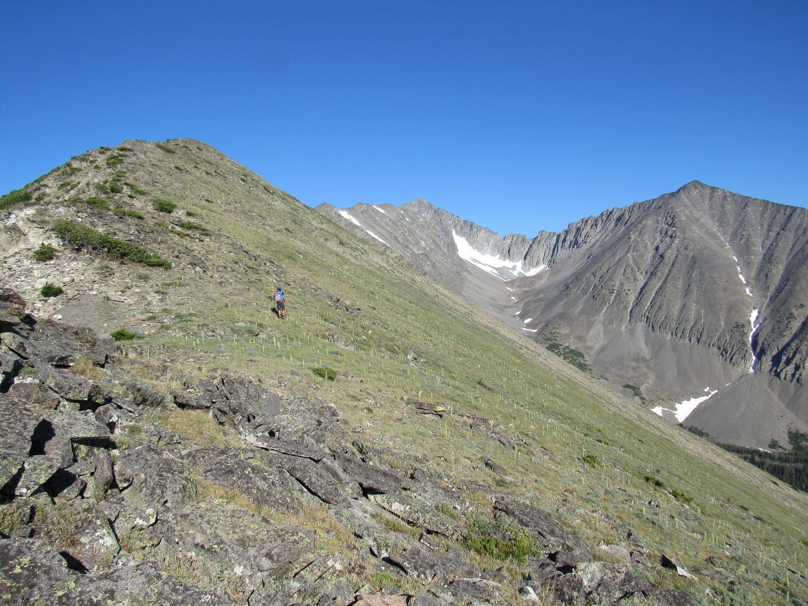
Despite falling behind, even SPHP was making reasonable progress. Things were still looking good for reaching the summit of Crazy Peak! The situation gradually changed, though, as the big ridge steadily narrowed and became rockier.
Getting closer, but as Lupe approached HP 9761, the ridge was already getting considerably narrower and rockier. Photo looks WNW.
By the time Looper made it to HP 9761, the ridge had narrowed down a lot. Vegetation was nearly gone. The ridgeline was rocky and uneven. Both sides of the ridge were steep, and comprised of a lot of loose rock. Here, the S side of the ridge wasn’t as bad as the N.
Jobe’s superior strength and stamina were now augmented by superior balance, too. No contest at all now. Jobe managed to simply walk the ridgeline in lots of places where SPHP felt compelled to down climb to get around rough spots. That burned a lot of extra time.
The agreement all along had been that Jobe should not wait for SPHP. While conditions were favorable, he really needed to get to the top of Crazy Peak. Time to check this one off the EPIC List! It would be great if Lupe and SPHP could get to the top, too, but there wasn’t the same degree of urgency. Lupe could still try to summit a little later than Jobe.
As the ridge became more difficult for SPHP, Jobe surged ahead. Lupe watched him go. Of course, her best bet for getting to the top of Crazy Peak would have been to just go with Jobe. Maybe she would have liked to, but she wouldn’t abandon SPHP.
Lupe watches as Jobe surges ahead. He’s now just a red spec on the ridge.Lupe’s best bet for reaching the summit of Crazy Peak would have been to go with Jobe, but she wouldn’t abandon SPHP. She would still get there, if SPHP could make it.Looking back. Here Lupe is past HP 9761 seen in the distance on the R. Photo looks E.
Looper and SPHP continued on, following Jobe who was getting farther and farther away. Eventually Jobe paused at a high point and looked back, checking on Lupe’s progress. For a moment he stood there, looking small, far away, and already much higher.
Jobe pauses and looks back to check on Lupe & SPHP a final time before disappearing from view. He was already a lot higher and quite a long way off. The telephoto lens makes Jobe look much closer than he really was. Photo looks WNW.
Jobe knew what he had to do. A moment later, he was gone. Lupe and SPHP were alone. There was nothing else to do, but keep chugging along.
Lupe presses on, still optimistic, though Jobe has disappeared from view. Photo looks S.Looking back down the SE ridge. HP 9761 in view. Photo looks SE.A long way to go yet. That high point ahead isn’t even the summit. Photo looks WNW.Looking SW.
Lupe was still making progress up Crazy Peak’s big SE ridge, but SPHP was frustrated with the pace.
Oh, Looper, I’m sorry, but maybe you should have gone with Jobe!
What! Why?
I’m just too slow on this steep, loose stuff. Our pace isn’t exactly scintillating, as you may have noticed.
Yes, but we’re getting there. We’ll just keep going like we always do.
True. So far so, good. Nothing’s stopped us yet, but I’m afraid we’ll run out of time. We can’t be coming back in the dark like we often do. Jobe has a 14 hour drive back home after this. He needs to hit the road so he can get back to work. Besides, this doesn’t seem to be getting any easier and who knows how bad the terrain is up ahead? Those last photos that Victor Zhou took looked questionable. We might not even be able to get there.
So Jobe might not get to the top of Crazy Peak? That would be terrible!
No, no. Don’t worry about that. Victor Zhou made it. Jobe will make it, too. But I’m not Victor or Jobe, not by a long shot. I’m not saying we won’t get there, but it seems like we’ve already been at this quite a while, and there’s no sign we’re anywhere near the top yet.
Well, hurry it up then!
I’m coming, sweet puppy. Lead on!
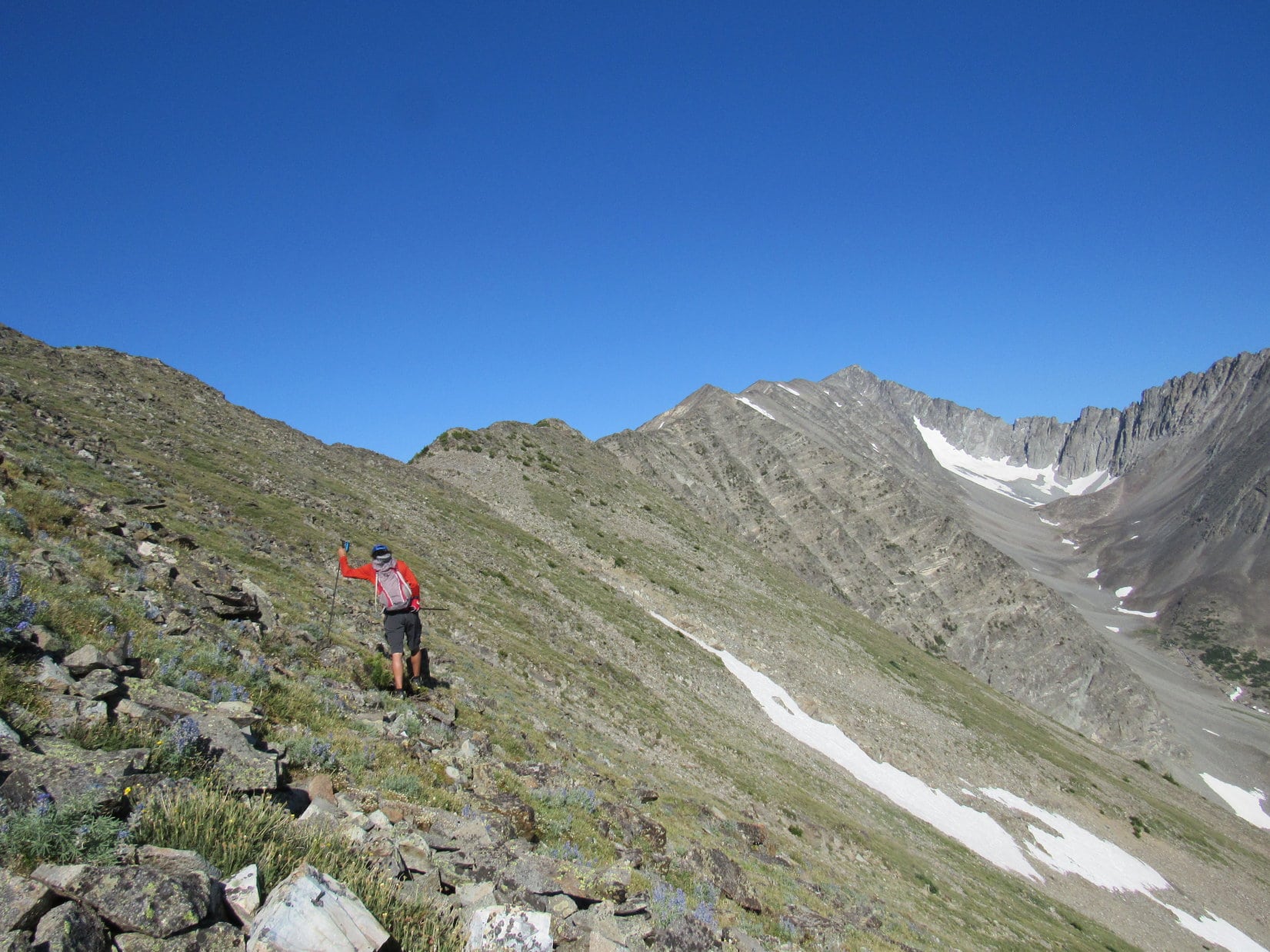
Lupe encourages SPHP up the next steep section. Photo looks WNW.
The summit of Crazy Peak had been out of view now for a while. It was hard to tell how encouraged or discouraged one should be. Lupe led the way up a couple of steep sections that went pretty well. The rocks were larger and more stable here. SPHP managed to make the climbs fairly rapidly. Maybe there still was enough time for Lupe to reach the top of Crazy Peak? Hope rekindled. It sure looked like Lupe was getting high!
After a spurt up a couple of steep sections, hope was rekindled that Lupe would still have time to reach Crazy Peak’s summit. The views were already terrific! Photo looks SE back down the ridge.Progress, but was it enough? Photo looks SE.
When the summit of Crazy Peak came into view again, it was a sobering sight. Despite SPHP’s spurt, Lupe remained a long way from the top of the mountain.
When the summit of Crazy Peak (R) came back into view again, it was a sobering sight. Lupe was still a long way from the top. Photo looks WNW.
Ugh! The summit’s still way over there, Looper.
Don’t give up! We’re getting closer.
Yah, keep going, but seems like Jobe’s been gone quite a while now. Sooner or later he’s going to reappear. Probably sooner I would think, and we aren’t going to be close enough to justify continuing on then.
Jobe didn’t appear, though. Lupe and SPHP carried on. Unfortunately, the ridge was messier again. SPHP kept down climbing to get around troublesome spots. Slow, slow, slow! Not good at all.
LOL, SPHP. We aren’t ever going to make it if you can’t stay up here! Lupe has a chuckle at SPHP’s endless down climbing.
Onward, bit by bit. Time ticked by. Though SPHP didn’t realize it then, the next big high point Lupe could see up ahead was 10,900+ feet. The ridge was ragged, but Lupe could get there! The summit would only be another 300 feet higher.
The high point on the L is 10,900+ feet, only 300 feet lower than Crazy Peak’s summit (seen beyond a little to the R). It looked like Lupe could at least get that far! Photo looks NW.
Pretty soon, though, a red dot appeared. A red dot headed this way. Jobe was returning! Had he made it to the summit? He’d been gone quite a long while – surely he’d made it? What news would he bring?
A red dot appeared on the ridge ahead. Jobe was returning! Had he made it to the summit?
There’s Jobe, SPHP!
Yes, I see him, too.
Aren’t we going to go meet him?
No, let’s wait here Looper. Jobe’s moving fast. He’ll be here soon enough. Let’s see what he has to say first.
Lupe and SPHP waited as Jobe worked his way back along the ridge.
A look through the telephoto lens at Jobe with Crazy Peak’s summit in the background. Photo looks NW.
As Jobe drew steadily nearer, SPHP took a few pictures of the views from this point Lupe had reached. It wasn’t completely clear yet if she would be going any farther.
Crazy Lake is seen below from the point Lupe reached on Crazy Peak’s SE ridge. Photo looks W.Big Timber Peak (10,795 ft.) (R) is connected to Crazy Peak by the sheer jagged ridge seen on the L. Probably the most challenging and technical route possible to Crazy Peak. No one goes that way. Photo looks N.Looking back the way Lupe had come. Photo looks ESE.
Jobe arrived all smiles. Success! Yes, he’d made it to the top. Crazy Peak was finally done. Only Mount Cleveland was left to do on his 50 states EPIC List! He graciously accepted congratulations from Lupe and SPHP.
Jobe returns all smiles! Yes, he’d made it to the top of Crazy Peak. Photo looks E.The grand view from Crazy Peak’s summit. Photo by Jobe Wymore.Jobe signed the Crazy Peak register. He had now completed the 50 US state most prominent peak list! Photo by Jobe Wymore.Lupe and Jobe celebrate Jobe’s success. Photo looks E.
Surprisingly, Jobe had met 3 young women at the summit who came up from yet another route. They’d camped overnight down at Crazy Lake, and had made a long trek on a steep, loose scree slope directly up the mountain. They were concerned about the prospect of the impending rather scary trip back down to camp. Jobe had spent some time talking to them, which was part of why he had been gone as long as he had.
So what was the rest of the route like? Jobe said there were a few spots that were kind of sketchy with some exposure. He’d gotten through just fine, though. He wasn’t sure what SPHP might think, or how Lupe would fare. A bit scary perhaps? Jobe nodded his head indicating Lupe and SPHP were free to go on and take a crack at it. Evidently he must have thought it was at least possible for Lupe to succeed. It was very kind of him to be willing to wait.
First – two more key questions. Jobe’s smart phone would have the answers. What time was it, and what elevation had Lupe reached here?
Early afternoon. Lupe is at 10,400 feet.
The summit of Crazy Peak looked a long way off. (It was actually only a little over 0.5 mile away.) Another 800 feet of elevation gain left, including some rough, sketchy territory with exposure ahead. Most importantly, it was now afternoon. Seven hours gone by already? At the pace SPHP was going it would take Lupe another two hours to reach the top of the mountain. By then it would be mid-afternoon. That meant part of the return trip would be in darkness.
There had been plenty of time to think about things while Jobe was gone. The terrain hadn’t stopped Lupe yet, but as much as SPHP would have liked for Lupe to succeed at climbing Crazy Peak, SPHP hesitated only a moment.
No, Jobe, we’ve timed out. Let’s head down.
Right decision. Lupe was happy. Jobe was happy. It was a relief to be going back down. The day was a big success! Jobe had made it to the top of Crazy Peak. Lupe and SPHP had shared in the joy, and kept their promise not to delay him – at least not by too much. Only Mount Cleveland to go! Jobe indicated he might take on Mount Cleveland sometime in early August, only 2 or 3 weeks away.
Well before the sun went down, Lupe and SPHP were back in Jobe’s air-conditioned Jeep Rubicon, bouncing along comfortably. Morning Dew and Terrapin Station by the Grateful Dead were playing. Jobe resumed his enthusiastic dissertation on Jerry Garcia’s musical talents. A good time, a really good time.
All too soon, Lupe was back at the G6, giving Jobe’s hand a final shake next to the Rubicon.
Pals Lupe and Jobe.Lupe extends final congratulations to Jobe on his great success at Crazy Peak.
Brief good-byes and well wishes, then onward! Jobe roared off in the Rubicon. Minutes later, Lupe and SPHP were in the G6 going down the same dusty road. Lupe resumed her usual watch for cows and horses to bark at.
After a fun day on Crazy Peak, Lupe resumes her watch for cows and horses to bark at.
SPHP soon stopped the G6 for a last look back.
Lupe’d had success climbing several nice peaks with Jobe on the previous two days. Nevertheless, Crazy Peak(11,209 ft.) would always be the one that stood out from the others. There it was, that long tantalizing SE ridge, forever leading skyward to the joyful moment when Lupe had stood with mountaineer and friend Jobe Wymore on the verge of EPIC!
Crazy Peak from the ENE.Lupe and Jobe Wymore on the verge of EPIC. Crazy Peak, Montana – July 22, 2017.
Thanks to Victor Zhou for sharing the route on the SE ridge that Jobe used to summit Crazy Peak, and gave Lupe some hope of doing the same.
Epilogue
Although Lupe and SPHP were confident Jobe would be successful climbing Mount Cleveland in early August, 2017, Lupe wouldn’t know for certain how Jobe fared until she returned from her Summer of 2017 Dingo Vacation in September.
Lupe arrived home on 9-13-17, to find an email from Jobe waiting for her entitled “Mount Cleveland denial. Weep, weep.” Jobe had arrived at the National Park visitor center only to be turned away due to forest fires that had started only the evening before. All backcountry permits via Goat Haunt had been cancelled.
So at the time of this post’s publication, Jobe remains on the verge of EPIC, only short Mount Cleveland from completing the 50 States of the USA EPIC List. Of course, in due time Jobe will be back. Lupe and SPHP wish him a speedy, successful and safe ascent! – 9-22-17
August, 2018 Update
Jobe eventually did complete the USA 50 States EPIC List more than a year after his adventure with Lupe on Crazy Mountain with a successful ascent of Mount Cleveland on 8-16-18. Congratulations, Jobe!