10:11 AM, 35°F – Gates close at dusk? Ridiculous! That’s what the sign said, though. The Alkali Creek trailhead for Centennial Trail No. 89 was huge and totally empty, but days are really short in December. SPHP wasn’t at all certain Lupe would be back before dusk, rendering the trailhead useless.
SPHP found a place to park along Horse Soldier Road. Lupe trotted back to the trailhead. Alkali Creek was the official starting point for today’s Black Hills expedition. Lupe was going to explore Centennial Trail No. 89 all the way N to the Fort Meade trailhead. At only 4.0 miles one way, this is one of the shortest segments between trailheads of the entire 111 mile long Centennial Trail.
Gates close at dusk? Lupe near the entrance to the useless Alkali Creek trailhead. She might or might not be back by dusk! Photo looks E.Loop at the official starting point for Black Hills, SD Expedition No. 241. Photo looks NW.
Lupe was anxious to get going! SPHP took only a quick peek at the posted trail map. It showed a surprisingly complex trail system in the area. Loop had no patience for it. Leaving the trailhead, the Carolina Dog crossed Horse Soldier Road. She picked up Centennial Trail No. 89 in a field on the other side.
Loop gets underway N of the Alkali Creek trailhead. Photo looks NE.
As Lupe sniffed along, the trail gradually curved N. Soon Bear Butte came into view. The summit of Bear Butte(4,422 ft.) is the official N end of Centennial Trail No. 89. Lupe wasn’t going that far today.
Bear Butte (L) starts coming into view as the trail curves N. Photo looks NNE.
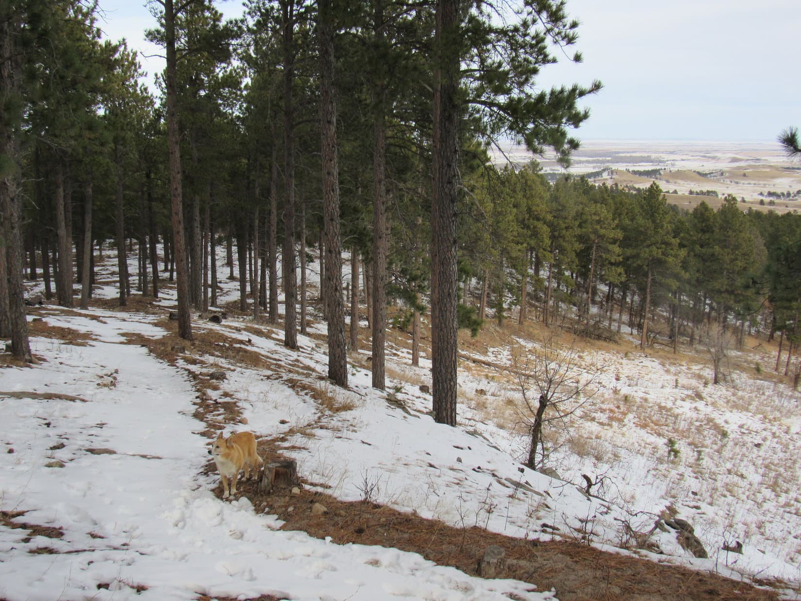
0.33 mile from the trailhead, Looper reached a junction at the top of a small rise. Centennial Trail No. 89 went W (L) here passing through a barbed wire fence. The other trail continued N through a long field.
Centennial Trail No. 89 goes W (L) here. Another route continues N through the long field seen ahead. Photo looks N.From this gate Centennial Trail No. 89 heads W into the forest. Photo looks W.
Beyond the fence, Centennial Trail No. 89 headed W toward a forested ridge Lupe had seen from the trailhead. Before reaching the trees, the Carolina Dog paused for the best view of Bear Butte yet.
Bear Butte. Photo looks NNE with help from the telephoto lens.
Once in the forest, Centennial Trail No. 89 wound NW up the E side of the ridge. The steepest part came near the beginning. Even here, the trail wasn’t bad at all. Lupe climbed through a forest of scrub oak and Ponderosa pines.
Loop rounds a bend early on the way up the ridge. Photo looks SE.Even along the steepest part of the ridge, the trail was quite easy. Photo looks N.Lupe had a good view from this rock. Photo looks SE.Heading W up a minor ravine.
Higher up, the slope of the terrain was more gradual. The trail trended SW for a while.
Higher up the terrain sloped more gradually. Photo looks SW.Getting close to the top of the ridge. Photo looks SW.
The ridge the trail was climbing is 0.75 mile long N/S. The W face of the ridge is much steeper than the E slope. Nearing the top of the ridge line, Centennial Trail No. 89 brought Loop very close to the S end of the ridge. Naturally, she stopped to check out the view. To the S, she could see I-90 and the Black Hills National Cemetery.
Loop at the S end of the ridgeline. Photo looks S.Looking S along I-90 with help from the telephoto lens.Zoomed in on part of the Black Hills National Cemetery.
Peak4027 is the high point of the entire ridge Lupe was on. It was only 200 yards N of the extreme S end. Centennial Trail No. 89 headed right for it. The summit proved to be spacious and gently rounded. Flanked by pines to the W and N, the whole area was grassy and open.
Approaching Peak 4027, summit of the entire ridge Lupe had climbed. Photo looks N.
Centennial Trail No. 89 didn’t go quite all the way up Peak 4027. Instead it swept around the E side of the spacious summit. Lupe had a great view of the prairies of western South Dakota.
Looking E over the prairies from Peak 4027.
Loopster wasn’t about to bypass the true summit of Peak 4027! She left Centennial Trail No. 89 to tramp through the snow looking for it. There wasn’t any definite absolute high point, but she explored enough ground to be satisfied with her ascent.
On Peak 4027. This high ground near a small stand of big pines seemed to be the true summit as far as it could be determined. Photo looks NE.
The scenic highlight from Peak4027 was Bear Butte rising dramatically like a miniature volcano from the surrounding prairie. Trees blocked any views of the main body of the Black Hills to the W.
Bear Butte is the scenic highlight from Peak 4027. Lupe is standing on a stump. Photo looks NNE.
Lupe returned to Centennial Trail No. 89. The trail continued N along Peak 4027’s long N ridge. Most of the ridge was forested. What it lacked in views, it made up in squirrels. Looper had a grand time barking and searching for them.
Back on Centennial Trail No. 89, still close to Peak 4027. Photo looks NW.Forest hid the views, but provided a home for squirrels and deer as Lupe continued N. Photo looks N.
Nearly 0.5 mile N of Peak 4027, Lupe came to another grassy area. She was approaching High Point 3983 on the topo map.
Approaching High Point 3983. Photo looks N.
At High Point 3983 Lupe reached a fork in the trail. A large post stood next to the fork. Centennial Trail No. 89 stayed to the L.
Lupe at the fork in the trail near High Point 3983. Centennial Trail No. 89 continues N passing L of the high ground. Photo looks N.
Beyond High Point 3983 the trail went NNW still following the ridgeline.
Back in the forest NNW of High Point 3983. Photo looks N.
0.25 mile from High Point 3983, Lupe finally reached the N end of the ridge. From rock outcroppings along the edge, the Carolina Dog could see Sturgis, SD to the NW. Peak3950 and Crook Mountain(4,930 ft.) were in view, too.
At the N end of the 0.75 mile long ridge. Peak 3950 (Center) is the hill beyond Lupe. Photo looks NNW.Sturgis, SD from the N end of the ridge. Crook Mountain is in the distance on the L. Photo looks NW.
Leaving the mountain’s main ridgeline, Centennial Trail No. 89 began a long gradual descent. After a switchback or two, Lupe found herself traveling NNE.
On the descent. Photo looks NE.
The trail curled clear around to the SW as it entered a large draw.
Lupe spots a squirrel as Centennial Trail No. 89 enters a large draw. Photo looks SW.
The draw drained NE. The trail turned NE again, too. More snow was down here. The draw brought Lupe back to Horse Soldier Road.
Down in the snowy draw. Photo looks ENE.Lupe reaches Horse Soldier Road again. Photo looks NE.
Centennial Trail No. 89 crossed Horse Soldier Road, but where it went on the other side wasn’t completely clear. Lupe searched for a marker. She found an icy pond off to the NW, but no markers. SPHP finally realized the correct route was the obvious one. Lupe followed a frozen road NE.
Heading NE after crossing Horse Soldier Road.
Having crossed Horse Soldier Road, the first part of Lupe’s journey to the Fort Meade trailhead was over. Until now, she had been up in the forest on the long ridge that was all part of Peak 4027. The remaining trek was lower territory. The trail was about to make several forays E toward the prairie, each time turning W again to re-enter the forest.
Following the frozen road, the American Dingo headed NE out into the grasslands. Centennial Trail No. 89 left the road near the end of a bare ridge, and climbed up onto it. Although this ridge was much lower than the forested ridge where Peak 4027 and High Point 3963 were, Loopster enjoyed unbroken panoramas.
Going up the first low ridge. The much higher forested ridge Lupe had just left is in the background. Photo looks SW.Bear Butte from the first low ridge. Photo looks NNE.View to the SE.Looking back. The Alkali Creek trailhead (Center) is way over at the base of the forested hills beyond the snowy grasslands. Photo looks S.
Fort Meade was already in sight only 0.5 mile to the N. The way the trail was going to wind around, Lupe still had a lot farther than that to go to get to the Fort Meade trailhead.
There’s Fort Meade! Photo looks NNW with help from the telephoto lens.
Now that Lupe was up on the ridge, the trail turned back to the WSW.
Having made it up onto the ridge, the trail heads back toward the Black Hills. Photo looks WSW.
The single track became a dirt road as Lupe drew near the forest again. For at least a little way, this was still Centennial Trail No. 89. However, when no more markers appeared, SPHP began to suspect the trail had disappeared somewhere into the forest on the N side of the ridge.
As Lupe got close to the forest again, the single track was evolving into a dirt road. Photo looks W.For at least some distance, Centennial Trail No. 89 followed the road. Photo looks W.
Lupe wasn’t far from Horse Soldier Road again when she spotted some still green pine slash snaking through the grass N of the snowy road. Upon inspection, it was evident this slash had been deliberately placed on a trail. Maybe Centennial Trail No. 89 had been re-routed? Perhaps this was an officially discouraged shortcut?
See the green slash? Maybe this is the way back to Centennial Trail No. 89? Photo looks N.
Lupe and SPHP followed the slash N down a snowy slope. Before long the slash led to another trail that was unobstructed. Continuing N, Lupe spotted a Centennial Trail No. 89 marker on a tree. Exactly where she’d lost the trail in the first place still wasn’t clear, but at least she was back on it again.
Back on Centennial Trail No. 89 again! See the marker on the tree on the L? Photo looks N.
The single track went virtually all the way back to Horse Soldier Road, but did not connect to it. Instead, right next to the road and a bit below it, the trail skirted around the W end of a forested ravine.
Heading NW on the S side of a ravine.
Once N of the ravine, the trail turned E again. Lupe was on the side of a fairly steep slope.
On the N side of the ravine now. Photo looks W.
The trail left the ravine going N along the E side of a hill. Lupe could see white headstones. Fort Meade National Cemetery was up on the hill. This small cemetery was established in 1878 by surviving members of General Custer’s 7th cavalry.
Fort Meade National Cemetery came into view. Photo looks NW.
After skirting the E and N sides of the cemetery, Centennial Trail No. 89 went around the W end of a much larger ravine. Again the trail turned NE following another ridge out toward the prairie.
Heading for the next ridge N of the cemetery. Photo looks N.Looking ENE along the ridge N of Fort Meade National Cemetery.
The trail went partway down the NE end of the ridge. Lupe enjoyed some nice views along in here.
Nearing the E end of the last ridge. Photo looks ENE.
Once more, the trail looped back around to the W and returned to the forest. Lupe climbed a little, then descended into a valley filled with snow. All these winding loops the trail had made had chewed up a lot of time. Never high in December, the sun was sinking toward the horizon.
The sun was already sinking when Lupe reached this snowy valley. Photo looks SW.
The valley floor was flat and fairly wide. A private home sat a little N of the trail. As Lupe went past it, the trail turned SW. There were tons of footprints in the snow, but Loop hadn’t seen anyone all day.
The far SW end of the valley was narrower. An odd stone building stood near the trail. Beyond it, Lupe could see Horse Soldier Road again. She dropped by the building to sniff around a bit, but discovered nothing of interest. The building looked like it had been abandoned for a long time.
Approaching the stone building. Photo looks W.Checking out the strange stone building.
The Carolina Dog pressed on. The trail headed N climbing a small hill. Lupe reached a minor pass. At the end of a short spur trail sat another oddity – a large stone fireplace.
This stone fireplace stood at the end of a short spur trail. Photo looks N.
A wooden fence enclosed the ground around the fireplace. No signs or plaques explained how or why the fireplace came to be here. Lupe left it just as mystified as she’d arrived.
Beyond the minor pass, Centennial Trail No. 89 made a long sweeping curve SW down into a snowy field. By the time the trail straightened out again, Looper was heading N. This was the final stretch. The Fort Meade trailhead was just ahead.
On the big curve leading to the final stretch. Photo looks NW.Almost there! Bear Butte (R) comes into view again. Photo looks NNE.Made it! Looper stands at the entrance to the Fort Meade trailhead. Photo looks N.At the information display. Photo looks W.
Lupe had made it! She had traveled the entire length of Centennial Trail No. 89 between the Alkali Creek and Fort Meade trailheads. It had been a pleasant, mostly easy trek offering a variety of terrain, scenes, and complete solitude.
SPHP had hoped Lupe would have time to climb Peak3950 on the way back to the G6, but the sun was already way too low for that. Even just retracing her entire route would take longer than desired. Time for a shortcut! Lupe and SPHP left the Fort Meade trailhead heading S on Horse Soldier Road.
The road was icy. After getting past the Fort Meade National Cemetery, a trail left the road heading S. A post said this was Trail No. 10. The trail looked like a shortcut that might lead down to the icy pond Lupe had seen earlier. Why not explore it?
About to leave Horse Soldier Road to venture down Trail No. 10. The end of Peak 4027’s long N ridge is seen on the R. Photo looks S.
Trail No. 10 went E along a steep slope with southern exposure. Sure enough, after 0.5 mile the American Dingo came to the frozen pond.
Looking down on the frozen pond from Trail No. 10. Photo looks SE.By the frozen pond. Photo looks SW.
Horse Soldier Road and Centennial Trail No. 89 were close to the pond. Lupe crossed the road. Enough daylight remained to retrace the rest of the trail. Lupe completed a second ascent of Peak4027 before dark.
Bear Butte from the same stump on Peak 4027 that Lupe had been on before. Photo looks NNE.
Light was fading by the time Lupe made it down off Peak 4027. It was dusk when she went past the Alkali Creek trailhead.
Gates still open! Could have parked there! Oh, well. A cold N breeze blew as Lupe and SPHP trudged along Horse Creek Road in silence. Didn’t matter. Not much farther to the G6 anyway. (4:49 PM, 33°F)
Bear Butte from Centennial Trail No. 89, 12-10-18
Notes – Horse Soldier Road goes from I-90 Exit 34 near the Alkali Creek trailhead to Hwy 34/79 a mile E of Sturgis near the Fort Meade trailhead. This road is also known as the National Back Country Byway or Cemetery Drive (N part) or Old Stone Road (S part).
Start – 8:33 AM, 39°F at the Gold Run trailhead, Deerfield Reservoir
Nearly mid-November, but such a beautiful morning that an expedition way out in the W central Black Hills seemed like a great idea. Loopster might not have many more chances to get out in the high country before winter set in. She arrived at the Gold Run trailhead by Deerfield Reservoir to find a skiff of snow already on the ground.
Lupe arrives at the Gold Run trailhead near Deerfield Reservoir in the W central Black Hills. Photo looks NE.
Lupe’s primary objective was an easy one. She was here for a romp around Deerfield Reservoir exploring Lake Loop Trail No. 40L. The 11.65 mile long trail would be perfect for a leisurely all day expedition this time of year. The American Dingo would encounter a fair amount of elevation gain and loss along the way, but in easily managed chunks without any truly steep parts.
Looper ready to set out on Deerfield Lake Loop Trail No. 40L. Photo looks NNW.
The Gold Run trailhead is located at the S end of an arm of Deerfield Reservoir. The plan was to follow Lake Loop Trail No. 40L clockwise around the lake. Lupe set off heading N along the W side of the bay. A thin shelf of ice covered by snow extended out from the near shore.
Flag Mountain(6,937 ft.) (Center L) is in view beyond the S arm of Deerfield Reservoir. Photo looks NNW.Gold Run trailhead (R) is at the end of this S arm of Deerfield Reservoir. Photo looks SE.
Lake Loop Trail No. 40L followed the S arm of Deerfield Reservoir N, but not all the way to the main body of the lake. Before getting that far, the trail turned W climbing a modest slope. At the top, Lupe found a road leading to a nearby picnic ground.
Nearing the main part of Deerfield Reservoir, Lake Loop Trail No. 40L turned W (L) here and climbed a modest slope. Photo looks NNE.
The trail followed the road a very short distance SW to a junction. Here Lupe turned R (NW) onto a road going downhill. 100 feet brought her to a marker where the trail left the road again. Lake Loop Trail No. 40L went W before heading S up a draw taking Lupe away from the lake.
Going S up a draw heading away from the lake.
After gaining some elevation, Lake Loop Trail No. 40L left the draw, crossed Whitetail Loop Road, and began gradually working its way W. The trail wound through ravines and along hillsides. Lupe was well S of the lake, glimpses of which were only occasionally in sight.
This part of the forest was full of deadfall timber. Fortunately, the trail was mostly free of it. Even so, Looper came to places where the trail would have been easy to lose. The trail was not marked at a couple of critical points. Paying a little extra attention went a long way toward staying on the right path.
S of the lake on hillsides strewn with deadfall timber. Photo looks SW.
Lupe got as much as 150 to 200 feet above lake level before Lake Loop Trail No. 40L started a steady descent. The trail eventually brought her down to Whitetail Loop Road again along the S shore near the W end of the lake.
Loop near the high point of the trail approaching the W end of Deerfield Reservoir. Photo looks W.On Whitetail Loop Road near the W end of Deerfield Reservoir. Photo looks W.
The trail followed Whitetail Loop Road only a short distance W before cutting NW across a small field. A sign commemorating Deerfield Dam & Reservoir stood 50 feet SW of the trail.
Starting around the W end of Deerfield Reservoir after leaving Whitetail Loop Road. Photo looks W.Near the commemorative sign at the SW end of Deerfield Reservoir. Photo looks NE.
After visiting the sign, Lupe returned to the trail. It took her around the W end of Deerfield Reservoir staying right beside paved Deerfield Road much of the way.
Back on the trail going around the W end of Deerfield Reservoir. Photo looks ENE.Following Deerfield Road. Photo looks NW.
Beyond the W end of the lake, a footbridge over Castle Creek came into view. Castle Creek is Deerfield Reservoir’s main water source.
The footbridge over Castle Creek comes into view. Photo looks NW.At the footbridge over Castle Creek. Photo looks N.Looking downstream. Photo looks SE.
Lupe crossed the footbridge. Lake Loop Trail No. 40L followed Castle Creek SE. Nearing the W end of Deerfield Reservoir again, Loop came upon a forested high point.
Nearby rocks offered a unique vantage point. The American Dingo left the trail for a look around.
Near the W end of Deerfield Reservoir again. Deerfield Road is now on the other side of the lake. Whitetail Loop Road (far L) is also in sight. Photo looks S.W end of Deerfield Reservoir. Photo looks SE.
Lupe’s travels along the most accessible portions of Deerfield Reservoir were now over. From here on she would be in more remote territory. Beyond the rocky viewpoint Lake Loop Trail No. 40L headed NE into the forest. Lupe followed abandoned roads with a bit of snow on them. For quite a while Deerfield Reservoir was no longer in view.
Following a snowy road. Photo looks E.For a while, Lupe didn’t see the lake at all. Photo looks E.
After more than a mile, Lupe reached a junction with a spur trail from the unseen North Shore trailhead.
Just past the junction with a spur trail from the North Shore trailhead. Photo looks SSE.
Shortly after passing this junction, Loopster reached a flat grassy area overlooking Deerfield Reservoir. A substantial portion of the main body of the lake was in view from here. Hat Mountain(6,779 ft.) could be seen off to the S beyond the lake.
Lupe reaches a large grassy area overlooking Deerfield Reservoir. Photo looks SE.Hat Mountain (Center) was in sight. Photo looks S.N slope of Hat Mountain with help from the telephoto lens. Photo looks S.Looking E from the grassy area.
Lake Loop Trail No. 40L now turned ENE paralleling the N shore of the lake. Lupe crossed hilly open terrain providing continuous lake views. Approaching High Point 6087 from the W, the trail re-entered the forest. Lupe gained elevation going around the S side of High Point 6087. (Scroll N from Hat Mountain on the topo map.)
Loop back in the forest with a tree-broken lake view on the way around High Point 6087. Photo looks S.
Most of the way around High Point 6087 trees effectively blocked the views. Lupe and SPHP took a short break near a lone spot where it was possible to get a decent look around. Green Mountain(7,164 ft.) and even the top of more distant Copper Mountain(6,920 ft.) could be seen.
Hat Mountain from close to High Point 6087. Photo looks S with help from the telephoto lens.Green Mountain (Center) and more distant Copper Mountain (L). Photo looks SSE.A glimpse back toward the W end of the lake. Photo looks SW.
Continuing on after the break, Lake Loop Trail No. 40L wrapped around the E side of High Point 6087, too. The forest permitted occasional glimpses of peaks in various directions. Lupe saw Hat Mountain again, and got a pretty good look at Nipple Butte(6,800 ft.).
Continuing around High Point 6087. Photo looks E.Another look at Hat Mountain (L of Center). Photo looks S.
At one point, shortly before reaching a shattered forest, SPHP thought Castle Peak(6,358 ft.) could be seen off to the NE. Thinking Lupe would get an even better look at it, SPHP failed to take a photo. Unfortunately, Castle Peak never came into view again.
Shortly before reaching this shattered forest, Lupe had a distant view of Castle Peak. Unfortunately, SPHP did not take a photo, and Castle Peak never came into view again. Photo looks NE.
Lake Loop Trail No. 40L continued winding around NE of High Point 6087. Lupe came to a view of another part of Deerfield Reservoir more to the E which hadn’t been in sight before. The Carolina Dog could see the start of the first of two NW arms of the lake. She would have to go around both arms.
Somewhere NE of High Point 6087. Photo looks WNW.A previously unseen portion of Deerfield Reservoir comes into view. The closest part is the start of one of 2 NW arms that Lupe would have to go around. Photo looks E.
The trail turned NW then began to lose elevation. The first NW arm of the lake wasn’t in view again until Lupe was nearly down to lake level. Looper crossed a wooden bridge over a tiny stream in a scenic draw. Around the next bend to the E was the W tip of the first NW arm.
Crossing the wooden bridge in the scenic draw. Photo looks NW.By the W tip of the first NW arm. Lupe still had to get past a N tip, too. Photo looks E.
This first NW arm of the lake also had a slightly larger N tip. Lupe was soon heading N again on the way around the N tip.
Beyond the N tip of the first NW arm. Photo looks NNW.
The trail continued N past the end of the N tip reaching a fence line at the S end of Reynold’s Prairie, an extensive area of grasslands. Lupe had a great view of South Castle Rock(6,840 ft.), Castle Rock(6,783 ft.), Nipple Butte(6,800 ft.), and Flag Mountain(6,937 ft.) from here.
South Castle Rock (L), Castle Rock (part of same ridge straight up from Lupe), Nipple Butte (R of Center) & Flag Mountain (far R) from the S end of Reynold’s Prairie. Photo looks NW.
The trail turned E. Deerfield Reservoir was left behind. Lupe crossed a road leading to the Custer Trails campground. Eventually Deerfield Reservoir came back into view.
After getting around the first NW arm of the lake, Lupe headed E for perhaps 0.5 mile before Deerfield Reservoir came back into view again. Photo looks SSW toward Hat Mountain (Center).
Soon the trail curved back around to the N again. Although it wasn’t in view yet, Lupe was getting close to the second and last NW arm of the lake. Lake Loop Trail No. 40L led across grasslands on the way N.
Looking back as Lake Loop Trail No. 40L curves N again. Hat Mountain is in the distance on the R. Photo looks SSW.Heading N once more through the grasslands of Reynolds Prairie. Castle Rock (L), Nipple Butte (Center) and Flag Mountain (R) are all in sight. Photo looks NW.
The second NW arm of the lake was longer than the first one, perhaps 0.25 mile in total length. Coming over the top of a grassy hill, Lupe saw the end of it ahead. She followed Lake Loop Trail No. 40 along treeless hillsides clear around the N end, crossing a tiny stream in the process.
Coming over a grassy hill, the N end of the second NW arm of Deerfield Reservoir comes into view. Photo looks N.Getting closer to the N end. Photo looks N.Looking back along the length of the second NW arm. Photo looks SE.
Once across, the trail followed the tiny stream SE back to the second NW arm. Lupe was only slightly above the level of the lake.
Heading back toward the second NW arm of the lake after crossing the tiny stream. Photo looks SSE.So far, so good! We’re easily over halfway around Deerfield Reservoir now! Looper down by the 2nd NW arm. Photo looks SSE.
After passing some pine trees on the way over a small rise, Looper came to a large grassy draw that led off to the E. She went through a gate in a barbed wire fence and found she had a couple of choices. She could go E on a trail heading up the draw, or follow a different trail back to the edge of the lake, hoping it would continue SE along the shore.
A sign did not clearly indicate which way the official trail went. Lupe and SPHP made a foray down to the lake. Nope. The trial faded away. The shoreline farther SE looked too heavily forested and steep to follow. Lupe headed E back up the draw, and soon came to markers for Lake Loop Trail No. 40L again.
The E draw (L) where there was confusion over which way the trail went is seen across the 2nd NW arm of the lake. Going R (SE) along the far shore was the wrong way and proved impractical. Lake Loop Trail No. 40L actually goes partway up the draw before turning R (SE) toward higher ground. Photo looks E.
Beyond the E draw, the trail headed SE or E across more open territory. Looking back to the NW, Lupe had her final views of South Castle Rock, Nipple Butte and Flag Mountain.
Looking back after going through one of more than half a dozen gates Lupe came to along Lake Loop Trail No. 40L. South Castle Rock (L), Castle Rock (Center), and Nipple Butte (R) are in view for the last time. Photo looks NW.
Lupe had now traveled the entire length of Deerfield Reservoir N of the lake. Lake Loop Trail No. 40L turned decisively SE. Lupe entered the forest again and started losing elevation. Before she had lost much, an opening on a hillside provided a first view of Deerfield Dam.
Deerfield Dam comes into view. Photo looks SSW.
Continuing a bit farther down the trail, Lupe discovered an even better viewpoint where she could see both the dam and Castle Creek. A nice spot for a rest break while enjoying the scene! Castle Creek roared as it shot out of two large culverts at the base of the dam.
Deerfield Dam & Castle Creek. Photo looks SW.Castle Creek gushes out of two large culverts at the base of Deerfield Dam. Photo looks SW with help from the telephoto lens.
When break time was over, Lupe returned to the trail, which now headed S down into the Castle Creek valley. Upon reaching the valley floor, Lake Loop Trail No. 40L continued S on a road over Castle Creek, but Lupe didn’t cross the creek yet.
Lake Loop Trail No. 40L didn’t go to Castle Creek’s outlet below Deerfield Dam, but a dirt road did. Lupe had even seen a side road that went right up onto the dam itself. Seemed like the American Dingo ought to explore these highlights while she was in the area.
Loopster began her off trail investigations trotting NNW up the dirt road to Castle Creek’s outlet at the base of the dam.
Come on! Let’s go take a look at Castle Creek roaring out from the base of Deerfield Dam! Photo looks W.This is it! Castle Creek comes gushing out of these two big pipes. Photo looks W.Here’s more of a side view. Photo looks NW.Wonder how much ice forms in the dead of winter?
After visiting Castle Creek’s exit from the base of Deerfield Dam, Lupe next went up the side road to the top of the dam itself. Deerfield Dam is oriented roughly NW/SE. Loopster reached the top of the dam near the NW end.
Deerfield Reservoir from the NW end of the dam. Photo looks S.Lupe at Deerfield Dam.Looking along the length of the dam. Photo looks SE.
The lake was beautiful from the NW end of the dam, but SPHP figured Loop might as well go see it from the SE end, too. She was glad she did. If anything, the views were even prettier from here!
Sweet! This might be the best view of Deerfield Reservoir yet! Photo looks WSW.Lupe at the SE end of Deerfield Dam. Photo looks W.Looking NW along the dam.
The side trip to the Deerfield Dam hadn’t taken all that much time, but it was definitely getting later in the day. Lupe and SPHP left the dam and returned to Lake Loop Trail No. 40 down by Castle Creek.
Looking upstream along Castle Creek below the dam. Lake Loop Trail No. 40L crosses the creek on a road over it near this point. This is the lowest elevation point along the entire trek around Deerfield Reservoir. Photo looks NW.
Lupe now took the road S over Castle Creek. This Castle Creek crossing was the lowest elevation point of the entire trek around Deerfield Reservoir. Lake Loop Trail No. 40L now began a long, steady, gentle ascent of a narrow, winding valley. This was the valley of Dutchman Creek. The creek was small, especially at first, but did have some flow.
Lupe starts up into the Dutchman Creek valley. Photo looks S.
0.25 mile up Dutchman Creek valley, Lupe came to a trail junction. She had been here once before a very long time ago on a day when she had been badly injured by barbed wire. Poor Looper had had to run many miles back to the G6 from here with a big bloody gash in one of her legs.
This junction was with Deerfield Trail No. 40, which goes 23 miles E to another junction with the 111 mile long Centennial Trail No. 89 before ending at the Deer Creek trailhead. SPHP had forgotten exactly where Deerfield Trail No. 40 meets Deerfield Lake Loop Trail No. 40L, but this was it. Lupe had found the junction again.
Lupe rediscovers the junction with Deerfield Trail No. 40 down in the Dutchman Creek valley about 0.25 mile SE of where Lake Loop Trail No. 40L crosses Castle Creek E of Deerfield Dam. Photo looks NE.
Without ever leaving the Lake Loop/Deerfield/Centennial trail system it’s possible to go all the way to Wind Cave National Park in the S or Bear Butte State Park in the N. Be that as it may, Loop just needed to head back to the G6 now. Another sign at the junction said she was a mere 2.5 miles from the Gold Run trailhead.
Another sign at the junction with Deerfield Trail No. 40 said Lupe was only 2.5 miles from the Gold Run trailhead where she had started out this morning. Photo looks S.
Lupe and SPHP continued S on Lake Loop Trail No. 40L. Dutchman Creek exhibited greater flow, not less, as Lupe progressed up the valley.
Continuing up the Dutchman Creek valley. Photo looks S.By Dutchman Creek near its point of greatest flow. Photo looks S.
Lake Loop Trail No. 40 eventually veered W. Dutchman Creek vanished. The trail continued on following dirt roads most of the time.
Heading WSW after the trail abandoned Dutchman Creek. Photo looks W.
Other unmarked roads began to intersect the road the trail followed. Which way? Trail markers weren’t reliably present at important points. The trail had been following a road S again for quite a way when Lupe came to a place where the road divided. S or W? A broken marker lay on the ground, but which direction it was supposed to point was no longer clear.
200 yards on the road going S revealed no more markers. Worse, the road seemed to be turning SE, definitely the wrong direction. Loopster returned to the junction with the broken marker. Taking the road W, another road quickly came into view at the far end of a field. Better yet, a single track trail angled S off the road Lupe was on into the trees. A pink ribbon tied around a tree highlighted a small marker nailed to the trunk.
No question now. Lupe headed S on the single track.
A little W of a confusing junction where the road divided, Lupe finds Lake Loop Trail No. 40L again (L) as it leaves a dirt road angling S into the trees.
For farther than SPHP expected, the single track went S paralleling the road Lupe had seen at the far end of the field. This was Deerfield Cove Road, which goes N to Dutchman Campground then on to a boat ramp on the S shore of Deerfield Reservoir. Lake Loop Road No. 40L finally turned W and crossed this road.
About to cross Deerfield Cove Road. Photo looks W.
The sun was low. Only a mile back to the Gold Run trailhead! Slanting sunbeams highlighted the forest as Lupe crossed the highest ground reached anywhere along Lake Loop Trail No. 40L. Looper was now in the vicinity of High Point 6248 and couldn’t have passed far from it.
Somewhere in the vicinity of High Point 6248, the highest ground encountered anywhere along Lake Loop Trail No. 40L. Photo looks W.Hat Mountain (Center) again as seen through the late afternoon sunlit forest. Photo looks SW.
The long gradual uphill stretch that had started way back at Castle Creek was over. The terrain near High Point 6248 was fairly flat for quite a distance. Finally the trail started down. Lupe was on the descent to the E side of the S arm of Deerfield Reservoir. When she got there, the Gold Run trailhead was in sight.
Lupe reaches the E shore of Deerfield Reservoir’s S arm. Gold Run trailhead where she had started out from this morning is in sight at the far S end. Photo looks SSE.
A shortcut across a field at the S end of the lake directly to the Gold Run trailhead would have saved a bunch of distance. However, the field was fenced off, and Lupe would have had to cross Gold Run Creek. So she stuck with Lake Loop Trail No. 40L, which went the long way around all the way S to Deerfield Road before turning back N to the trailhead.
Looking back at Gold Run trailhead (L) from Lake Loop Trail No. 40L near Deerfield Road. The trail sure took the long way around to get there! Photo looks NNW.
The sun was still up, but not for much longer, when Lupe reached the Gold Run trailhead again. (End – 4:12 PM, 41°F) The American Dingo had successfully explored all of Lake Loop Trail No. 40L. She’d gone clear around Deerfield Reservoir. Even so, Loop wasn’t quite done yet.
Barely enough daylight left for a quick peakbagging effort! The sun was so low, SPHP drove Lupe W to USFS Road No. 691 (Williams Draw Road), then S to a side road only 0.5 mile N of Hat Mountain.
Lupe had seen Hat Mountain(6,779 ft.) from so many places on Lake Loop Trail No. 40L, that climbing it seemed like a great way to end the day. Up and back wouldn’t take long. No sense in lugging the backpack along was there? SPHP left it in the G6. (Start – 4:19 PM, 41°F)
Lupe followed USFS Road No. 691 a little farther S before plunging into the forest. Halfway up the NE slope, SPHP realized leaving the backpack behind meant no flashlight. Doh! Too late to go back for one now. Just another reason to hurry. No flashlight meant Loop wasn’t going to get to tarry more than a few minutes up on Hat Mountain.
The sun was already down by the time Lupe reached the summit, but the sunset was still developing. The Carolina Dog could linger enjoying the colorful display a bit longer than expected.
Lupe (R) reaches the flat summit of Hat Mountain just after sunset.Reynolds Prairie (Center) and part of Deerfield Reservoir (R) from Hat Mountain. Photo looks N.Green Mountain (L) from Hat Mountain. Photo looks S.
The glory of sunset faded as quickly as it arrived. The rush back down to USFS Road No. 691 began. Sensing the urgency SPHP felt, Lupe charged ahead.
Made it with photons to spare! A short easy road hike back to the G6, and Expedition No. 240 was done. Another adventure come and gone. No complaints. None at all. Lake Loop Trail No. 40L had been a perfect day. (End – 5:16 PM, 39°F)
Sunset from Hat Mountain, Black Hills of South Dakota, 11-14-18
Gold Run trailhead directions: From Hill City take Deerfield Road (Highway 17) 14.6 miles NW to a signed R turn onto a dirt road. The trailhead is visible from this turn 0.2 mile to the N.