Black Hills, SD Expedition No. 198 – Peak 4160 & Unkpapa Peak (4-2-17)

Start (9:50 AM, 61°F), intersection of 7-11 Road & Red Valley Road several miles SE of Wind Cave National Park.

Wow!  A perfect spring day for bagging a couple more Black Hills peaks – blue skies, calm, almost room temperature.  Even though April was barely underway, it might even get a little too warm in another couple of hours.

Lupe was excited.  She’d already had a great time barking at cows and horses from the G6 all the way to Buffalo Gap.  She’d seen one of her two peakbagging goals for the day, too.  SPHP had let her out of the G6 for a couple of minutes for a quick look at Unkpapa Peak (4,280 ft.).

Unkpapa Peak from Red Valley Road (County Road No. 5). Photo looks S.

Before taking on Unkpapa Peak, Loop had other business to attend to.  For the past several months, she had been working on climbing southern Black Hills peaks Brian Kalet had added to the Peakbagger.com data base last May.  Now she was almost done.  One more Brian Kalet peak remained – Peak 4160.  Lupe was going to get Peak 4160 over and done with first.

Crumbly and steep – a bad combination!  The route SPHP choose to start off with was silly and unnecessary.  The red dirt of the steep hillside was damp and messy.  The white gypsum rock crumbled easily, providing unreliable support.  Lupe didn’t have a problem negotiating the hillside, but it took SPHP a while to reach the more solid gypsum cap at the top of the hill.

Lupe had no problem climbing this steep, crumbly hillside, but it sure slowed SPHP down. This was a crazy route up Peak 4160, anyway. Lupe would soon have to lose nearly all the elevation she gained climbing this hill before even starting up the main ridge.

On the other side of the hill was a pine forest and easier terrain.  Unfortunately, Lupe had to lose nearly all the elevation she had just gained.  The ground sloped down into a series of ravines she had to go around or through.

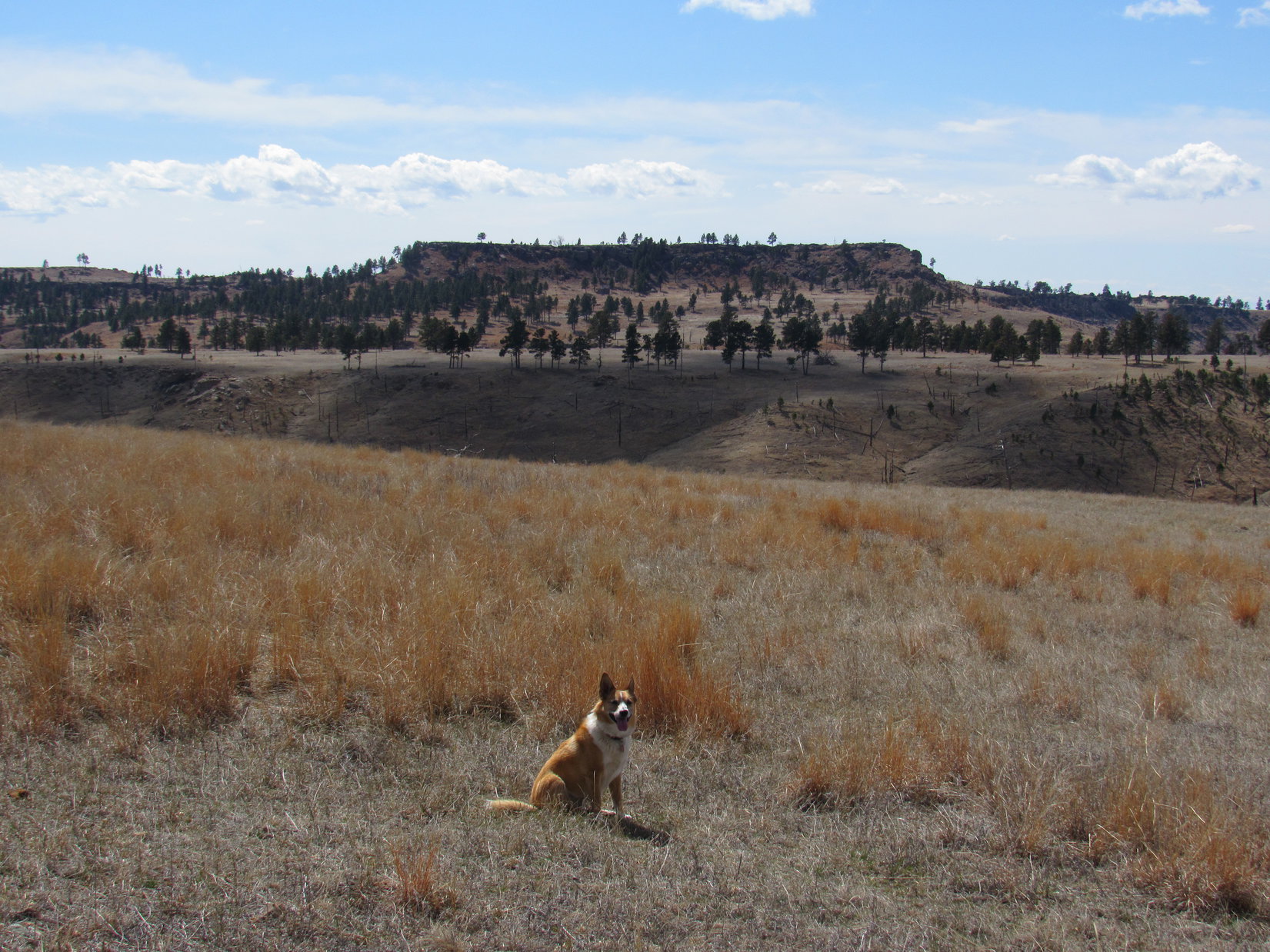
Once she was past the last of the ravines, Lupe started a steady climb up the W face of Peak 4160.  The forest thinned out rapidly.  On the upper slope few trees were left to block the steadily improving views.

As Lupe climbed the W face of Peak 4160, the forest dwindled away rapidly. From the upper slopes she had a great view of Unkpapa Peak (L). 7-11 Road is seen below. Photo looks SSW.

Down in the forest Lupe hadn’t seen much cactus, but up on the sunny, barren, upper slope it was a different story.  The higher Lupe went, the more cactus she found.  By the time she reached the ridgeline, Lupe was not a happy Dingo.  She begged SPHP to carry her, or at least scout out the route ahead.

With so much cactus on Peak 4160, Lupe insisted that SPHP scout ahead for danger before she would follow. Here she’s on her way having received the signal that this next part of the route was cactus-free. Photo looks SE.
Good job, SPHP! No cactus at all on that last stretch. Take your time and keep up the good work. I’ll wait here until you give the signal. Make sure you don’t miss any!  My paws are at stake!

Peak 4160 is a long ridge running almost straight N/S.  The W face is quite steep, but the mountain slopes away only gradually to the E.  Lupe had come up well S of the high point, which the topo map showed was somewhere quite close to the W edge.  She headed N along the edge looking for the true summit.

Cactus was the only serious obstacle.  With SPHP’s scouting help, and an occasional lift over the worst of the cacti, Lupe arrived at a line of small rocks of almost equal elevation.  These rocks were the true summit of Peak 4160.  It was a great moment.  Lupe had done it – she had climbed the last of her Brian Kalet peaks in the southern hills!

Lupe reaches the true summit of Peak 4160, the last of the Brian Kalet peaks she was going to climb in the southern Black Hills. She was pretty happy, thinking this was the last cactus-infested mountain she would have to climb. SPHP hadn’t sprung the news about Unkpapa Peak on her yet! Photo looks N.
Lupe found this line of small rocks at the top of Peak 4160. They were 20 or 30 feet away from the W edge of the mountain. Photo looks S.

The topo map showed two separate areas on the mountain within 4,160 foot elevation contours.  Brian Kalet had marked the southernmost of these areas as being the location of the true summit.  Lupe had reached this S area first, and she could see the next high point to the N from here.  It definitely looked a little lower.

Lupe was glad!  She was already at the true summit and could skip the remaining cactus-infested trek to the N high point.

The rocks of the true summit were 20 or 30 feet from the edge of the steep W face of the mountain.  Of course, the edge was where all the best views from Peak 4160 were.  Naturally, Lupe went over to check them out.

The best views from Peak 4160 were along the W edge of the mountain. Although blue skies had prevailed when she started up, Lupe could now see clouds building to the NW. Photo looks NW.
Unkpapa Peak (L) from Peak 4160. Photo looks SSW.
Gravel 7-11 Road stretches away to the SW. Lupe had come up Peak 4160 through the forest seen below on the L. Photo looks SW.

Happy with the last of the Brian Kalet peaks already in the bag, Lupe returned to the true summit briefly before starting her trek back down the mountain.

Lupe returned to the true summit briefly before starting down. Photo looks E.

She began her return to the G6 heading S along the W edge where the views were best.  Before leaving the ridgeline, Lupe stopped briefly at a couple of points along the way.

Looking W before leaving the ridgeline.
Looking NNW.

Although it had been sunny and warm earlier, by the time Lupe was down the skies were gray.  A cool wind was blowing.  Off to the NW, it looked like rain.  Lupe passed by an ancient windmill, the old blades still capable of spinning in the breeze.

By the time Lupe was down off Peak 4160, the weather had changed. The skies were gray, a cool breeze was blowing, and it looked like rain to the NW. She passed by this ancient windmill, its old blades still spinning in the wind. Photo looks SW.

At 1:15 PM, Lupe jumped into the G6 when SPHP opened the door.  Was she ever surprised when SPHP politely informed her she wasn’t going anywhere until she climbed Unkpapa Peak, too!

Loopster was fine with that!   Carolina Dogs are always ready for the next adventure.  Lupe abandoned the G6, and started for Unkpapa Peak.  Her journey began below a line of low cliffs near the edge of a dry creek bed.

Lupe passed by this line of colorful low cliffs to start her journey up Unkpapa Peak.

After crossing some easy open ground, the terrain became steeper as Lupe climbed up through a forest.  Her route was steepest near the end of the climb where only scattered trees remained.

Lupe on her way up Unkpapa Peak. The steepest part of the climb is directly ahead, but wasn’t at all difficult. Photo looks SE.

Lupe reached the top of the Unkpapa ridge at its northernmost point.  The weather had continued to deteriorate.  Up here it was windy and cool.  SPHP was putting layers back on, but Lupe had to make do with the same lovely brown and white fur outfit she wears in all kinds of weather.

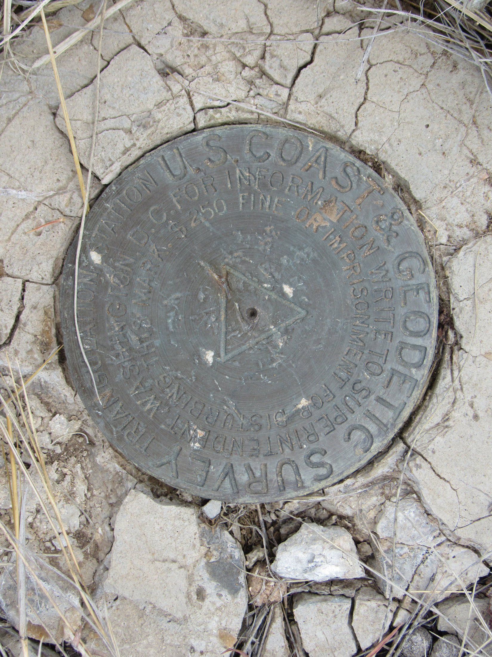
Like Peak 4160, Unkpapa Peak features two different areas contained within equally high elevation contours.  That meant two possible sites for the true summit.  On Unkpapa Peak, these two areas are separated by more than a mile.  The topo map showed a survey benchmark at the N high point, which wasn’t too far away from where Lupe reached the N rim of the mountain.  The name Unkpapa Peak was also shown at this point on the map.

While Lupe headed ESE along the edge of the N face on her way to the closest summit, SPHP kept an eye out for the survey benchmark.

Looper stands in the cool wind along the N rim of Unkpapa Peak, a little E of where she first came up. American Dingoes are not fans of wind. Photo looks E.
The N high point of Unkpapa Peak is visible on the L. Lupe didn’t have far to go to get there. The skies were still blue to the E, but Loop wouldn’t see the sun in all her time up here since clouds continued to move into the area. Photo looks ESE.
Lupe still standing in the wind along the N rim. The weather looked increasingly stormy off to the NW (L). The intersection of 7-11 Road and Red Valley Road is seen below. A quarry is in view on the far side of 7-11 Road. Photo looks NNW.

Lupe hadn’t seen much cactus on the way up Unkpapa Peak, but when she reached the top of the ridge there was plenty of it around.  SPHP’s scouting and Port-A-Puppy services were called into play again.  Lupe still hates cactus, but with all the cactus-infested mountains she’d been climbing recently in the southern Black Hills, she was getting fairly used to dealing with it.

Lupe made good progress along the N rim toward the summit.  SPHP was surprised when she found a survey benchmark a couple hundred yards before reaching the high point.  The topo map only showed a benchmark at the top.

Lupe found this survey benchmark a good 200 yards W of the N summit.

The cactus was annoying, but could not stop Lupe from reaching the N summit.  She arrived to find a couple of modest rocks at the very top.  Lupe got on them to claim 1/2 of her peakbagging success on Unkpapa Peak (4,280 ft.).  This summit was quite close to the N rim, but thankfully trees along the edge helped block the N wind.

Shortly before reaching the N summit, Lupe came to this great view of Buffalo Gap. Photo looks ENE.
Almost there! A happy Carolina Dog awaits another cactus all clear signal from SPHP. She’s almost to the N summit of Unkpapa Peak. Photo looks WNW.
Ta da! Looper stands atop the N summit of Unkpapa Peak. Photo looks E.

After reaching the N summit, Lupe looked around the area close by for both the best view of Peak 4160 from Unkpapa Peak and another survey benchmark.  A break in the trees along the N rim provided a great look at Peak 4160, but there didn’t seem to be a second survey benchmark.

A break in the trees along the N rim provided a great look at Peak 4160 (the closest big ridge) from Unkpapa Peak. Photo looks NNE.
Peak 4160 with some help from the telephoto lens. Photo looks NNE.

Lupe and SPHP took a break under a big pine tree a little back from the N edge where the wind wasn’t so strong.  Lupe had eaten some Taste of the Wild up on Peak 4160, too, but she was still kind of hungry.  She had another helping.

Even under this pine tree there was cactus.  Hopefully, Unkpapa Peak was to be the last of the lower southern Black Hills peaks with cacti that Lupe would have to climb for a long time.  She sure wouldn’t miss the cactus.  Neither would SPHP.

One thing Lupe wouldn’t miss from these lower, drier southern Black Hills peaks was all the blasted cactus.

Yet it had to be admitted that despite the lower elevation of these southern peaks, the drier climate where cactus thrived and trees didn’t fare as well had provided Lupe many outstanding sweeping views unlike those found in the much more heavily forested Black Hills typical farther N.

After the short break beneath the pine tree, Lupe returned to the summit rocks, which were close by.  On the way, SPHP noticed a second survey benchmark.  So there was one here after all!  It was a little S of the highest rocks.

As Lupe returned to the summit rocks after her break, SPHP noticed this second survey benchmark a little to the S of the highest rocks.
Lupe back at the N summit after her break. Although the N and W faces of Unkpapa Peak are fairly steep, the top of the mountain is a gently undulating plain. The S summit, more than a mile to the SW is in view on the L. The trees on the R are all near the edge of the W face. Photo looks SW.

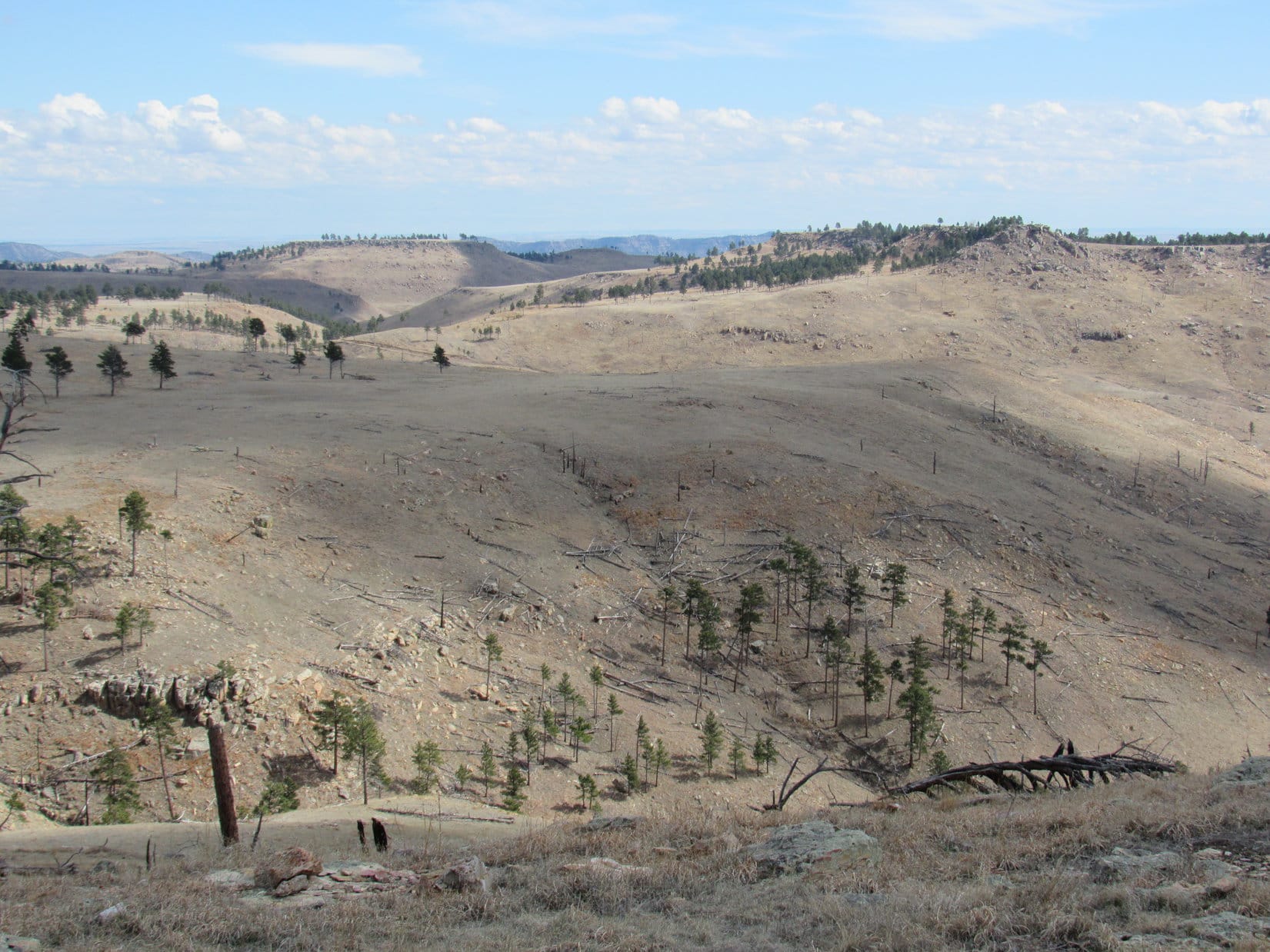
The N and W faces of Unkpapa Peak are fairly steep, but the top of the mountain is a gently undulating plain.  Looking SW across this plain from the N summit, it was possible to see several high points more than a mile away, but it was hard to tell which might be the S summit.

To really claim a completely valid peakbagging success on Unkpapa Mountain, Lupe would need to visit the S summit as well.  If the topo map was correct, odds were that the S summit was also technically the true summit, since the area enclosed by the 4,280 foot contour was much larger over there.

Lupe headed SW across the undulating plain.  Cactus was a constant threat, but wasn’t nearly as thick as it had been along the N rim.  Lupe and SPHP enjoyed the easy stroll.  The wind wasn’t nearly as bad here as along the N rim.  The air was comfortably cool.  Meadowlarks were singing.

Lupe discovered a huge bone.

Looper found this huge bone shortly after starting on her way to the S summit. Too bad it had long been completely picked over. What a prize it would have been fresh!

Unfortunately, the huge bone had been completely picked over long, long ago.  By all appearances, it had been laying here bleaching in the sun for years.  What a glittering Dingo prize it would have been when fresh!  Lupe was way too late for that.

The next thing Lupe found was of much more practical use.  She came to a trail!  The trail meant an almost guaranteed cactus-free path.  Lupe was enthused.  She took the lead, running back and forth ahead of SPHP.  She was making rapid progress now.

After finding the trail, Lupe made rapid progress. Although SPHP wasn’t certain of it yet, the barren ridge seen slightly R of Center behind her proved to be the S summit of Unkpapa Peak. Photo looks SSW.
Looking NE back at the N summit of Unkpapa Peak from a small, rock-covered hill. The trail Lupe had been following is in view on the hillside.

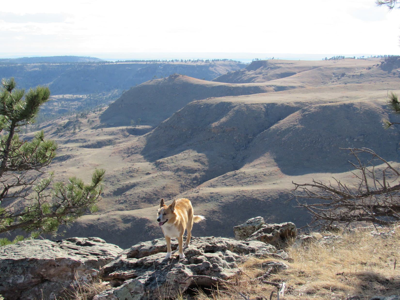
Suddenly there was movement ahead!  A small herd of deer had become aware of the approach of a ferocious American Dingo.  They quickly bounded out of sight over the W rim of the mountain.  Lupe raced over there.  From the edge, she was disappointed to find the deer had vanished, but she did get a good look at the stormier conditions prevailing over the higher Black Hills to the NW.

A small herd of deer bounds away before disappearing over the W edge of Unkpapa Peak. Photo looks SW using the telephoto lens.
From the W rim of the mountain, Lupe caught no sight of the deer, but did see the stormier weather prevailing over higher hills to the NW. She would rather have seen the deer.

It wasn’t much farther now to a rocky ridge that might be the S summit of Unkpapa Peak.  Lupe stayed neared the trees along the W rim of the mountain as she traveled S toward the ridge.  A disturbing amount of cactus was present whenever she ventured away from the trees.  SPHP had to help her past it in a few places.

The ridge itself was barren, but didn’t have as much cactus.  Upon reaching the top, it became clear this ridge was indeed the S summit.  Lupe had made it!  A 75 foot long line of modest to good-sized rocks and boulders of similar elevation formed the highest part of the ridge.  Lupe got up on several of the highest rocks for a look around.

Lupe reaches the rocky ridgeline at the S summit. Photo looks SW.
Looking W.
Looking NE back at the N summit. The N summit appears to be considerably higher in this photo, which is deceptive. While actually there, both the N and S summits did seem to be about the same elevation.
From a distance, it had been hard to tell if this ridge was actually the S summit or not. However, this view from the top looking WSW over the next canyon left no doubt.

The most dramatic views were off to the W and N, but Lupe could see in every direction from the barren S summit.

Pines line the edge of the W rim of the mountain. Lupe could see far beyond them. Photo looks N.
Lupe had a big view to the NW, but rain showers hid the higher, more distant hills.

Reaching the S summit meant that Lupe’s peakbagging tasks were complete on Unkpapa Peak.  Whether the N high point or the S high point was the true summit didn’t really matter now.  Lupe had been to both.

For 20 minutes or so, Lupe and SPHP remained up on the S summit.  Looper had plenty of time to get back to the G6, but there was no rush.  It was too late in the day for another adventure.

The wind blew, but not as strongly as it had earlier along the N rim.  The sky tried to spit rain, but didn’t achieve much in the way of results.  The air was cool, but not cold.  Lupe and SPHP stayed together on the rocks, enjoying the panorama from Unkpapa.

Even though she wasn’t that far from home, it might be a long time before Lupe returned for another expedition this far S in the Black Hills.  The Brian Kalet peaks Lupe intended to climb were finally complete.  Except for the cactus, the last few months climbing them had been surprisingly fun.

An American Dingo lingers atop the S summit of Unkpapa Peak. Photo looks ESE.

On the way back N, Lupe took the scenic route staying near the W rim for the huge view.  The farther N she went, the more cactus there seemed to be, but SPHP helped the Carolina Dog through it.

Looking back at Unkpapa’s S summit. Photo looks SE.
The grand view from the NW rim of Unkpapa. Photo looks N.

Lupe went back down the N face about where she’d come up.  A colorful hill to the NW caught SPHP’s fancy.

This colorful small hill caught SPHP’s fancy on Lupe’s way down. Photo looks NW.

It was still early when Lupe reached the G6 (5:11 PM, 47°F).  She had plenty of daylight for enormously satisfying frenzied barking at the numerous cows and horses she saw on the drive home.

For the 3rd expedition in a row, Lupe celebrated the end of the day with a chocolate milkshake from the Sonic Drive-In.  The milkshake was fancied up with whipped cream and a cherry on top.

American Dingoes love whipped cream!  The cherry?  It was graciously ceded to SPHP.

Links:

Next Black Hills Expedition                      Prior Black Hills Expedition

Want more Lupe adventures?  Check out her Black Hills, SD & WY Expeditions Adventure Index, Master Adventure Index, or subscribe free to new Lupe adventures!

Black Hills, SD Expedition No. 197 – Parker Peak & Horse Trap Mountain (3-27-17)

Start (10:49 AM, 54°F)

Crocuses!  Lupe discovered pale, lavender crocuses along the trail, not many, but a few here and there.  No denying it now, spring had arrived in the Black Hills!  As far as Lupe was concerned, crocuses were infinitely better than the cacti she had been reluctantly dealing with on her recent Black Hills expeditions.  SPHP couldn’t have agreed more.

Crocuses herald the arrival of spring in the Black Hills.

The trail had led Lupe right up to the top of the broad ridge.  The ridge ran for miles E/W, and had a number of large extensions to the S.  Most of the ground up here was rolling grasslands, rimmed by Ponderosa pines along the edges, with more pines scattered in various places across the open ground.

Lupe arrives up on the broad ridge that ran for miles E/W. The survey benchmark, at the top of the pipe seen sticking up out of the ground beneath her, provided SPHP with a good indication of her precise location. Photo looks SW.

The question was, which way to go from here?  The plan was to follow 4WD roads up on this huge ridge to Lupe’s two peakbagging objectives of the day – Parker Peak (4,848 ft.) and Horse Trap Mountain (4,682 ft.), but neither mountain was in sight, nor was any road visible.  Maybe the old roads shown both on the Peakbagger.com topo map and SPHP’s old Black Hills USFS map didn’t even exist anymore?  Entirely possible.

What was for certain was that Parker Peak, the high point of Fall River county, was miles away at the far W end of this ridge.  Horse Trap Mountain, however, was somewhere closer by to the S.  Maybe it was still E of here?

Lupe explored E along a fence line, going up to the crest of a gentle rise where a few large pines were clustered.  Looking E and SE from here revealed nothing.  All the terrain was nearly as high, and a lot of it was forested.  No sign of Horse Trap Mountain.

The only thing Lupe discovered by going E was that crocuses weren’t present up on top of this ridge.  Instead, her feared cactus nemesis was.  Not a lot of cactus, but enough so SPHP carried her over one small patch.  The cactus wasn’t a surprise, SPHP had expected it.  Even up on this high ridge, Lupe was still below cactus line.

Going farther E didn’t look promising.  Lupe retraced her steps, returning to where the trail had first brought her up to the top of the ridge.  At the fence corner, Lupe came to a pipe sticking up out of the ground.  SPHP hadn’t noticed it before.  A survey benchmark at the top of the pipe provided a clue, such a good clue that after consulting the maps, SPHP knew exactly where Lupe was.  Horse Trap Mountain was more than 2 miles SSW of here.

SPHP started leading Lupe WSW down toward an earthen dam for a dried up stock pond.  However, Loop was now wary.  The foray to the E had shown her that cactus was present.  She followed SPHP reluctantly.

Crossing the earthen dam, Lupe didn’t notice the one cluster of cactus growing on it.  Her confidence started returning.  SPHP enticed her SW up to the top of the next rise without much of a problem.  By staying where there were trees, the chance of encountering more cactus was reduced.

Unfortunately, the ridge didn’t have enough trees to provide continuous shade.  Lupe soon realized cactus was up here, too.  She insisted upon returning to her now familiar method for dealing with cacti.  The Carolina Dog stood or sat motionless while SPHP scouted ahead.  She would only come when SPHP sat on the ground to signal that the route was safe.

In some places it wasn’t safe.  SPHP had to carry the American Dingo a few times over the thicker cactus patches.  It would sure help to find a road, any kind of a road.  Lupe would be willing to trot along a road confident that cactus wouldn’t be on it.

Lupe was in luck!  A little down over the other side of the rise, she did find a road.  The road was faint and seldom used, even grassy, but it was a road.  Upon reaching it, Lupe was immediately relieved of the worst of her cactus worries.  She was willing to travel the road without her time consuming cacti technique being employed.

The grassy road went S.  Within minutes, Lupe passed by the ruins of an old cabin.  A little farther on, the road came to a major intersection in a clearing.  Dirt roads radiated out in 4 or 5 directions.  Ahead, across a tree filled canyon, Lupe saw an interesting butte in the distance.  SPHP didn’t realize it at first, but this was Lupe’s first view of Horse Trap Mountain.

Lupe near the major dirt road intersection. The butte in the distance is Horse Trap Mountain. Photo looks SSW.

A canyon was between Lupe and the interesting butte.  Consulting the topo maps, SPHP realized the interesting butte was very likely Horse Trap Mountain.  To get there, Lupe would have to take the road leading W.  If it was the road shown on the topo map, it would soon make a big detour to the NW to get Lupe around the end of Falls Canyon.

The road did exactly as the topo map showed.  Not only was Lupe ever more confident about the cactus situation, but SPHP was increasingly confident of the existence of the road system shown on the topo map.  Things were going well!

After rounding the NW end of Falls Canyon, the road turned S.  Lupe hadn’t gone as far S as the map showed she would need to in order to reach a turn to the W, when another road angling that direction appeared.  After another quick map consultation, SPHP concluded this road was most likely a short cut to Parker Peak.  Did Lupe want to go there first or to Horse Trap Mountain?

Lupe went W for Parker Peak.  The short cut worked.  The new road eventually intersected the main route shown on the topo map.  Everything went fine.  The roads, which were only a mix of dirt and grass the entire way, served as a Dingo superhighway.  Lupe was making great progress!  It was an easy trek.  The route was level or close to it most of the time.  What elevation changes Lupe came to were all gradual.

She often had beautiful views along the way.

Lupe enjoyed beautiful views on her way to Parker Peak. The high ridge in the distance is more than a mile SE of Parker Peak. Photo looks SW across Hell Canyon.
The high point straight up from Lupe is the top of Parker Peak protruding barely above an intervening lower ridge. Photo looks W.
View to the NW. The dark high point on the far horizon a little R of Center is Wildcat Peak (5,500 ft.).  The ridge on the far R is Elk Benchmark (5,669 ft.). The closer forested hill on the L is an unnamed peak a couple miles N of Matias Peak.

As Lupe got closer to Parker Peak, the views gradually changed.

The same unnamed ridge SE of Parker Peak, but now looking SSW at it across Hell Canyon.
Another view to the NW, this time looking a little more N with less help from the telephoto lens.
Looking down Hell Canyon toward Horse Trap Mountain (R of Center). Photo looks SE.

The road passed to the N of a skinny lower ridge 0.5 mile E of Parker Peak.  Lupe left the road to climb up on the skinny ridge for a good view of her objective, now in clear view.

Parker Peak from the skinny ridge 0.5 mile to the E. The skinny ridge was topped with colorful rocks. Photo looks W.

Lupe returned to the road after leaving the skinny ridge.  She was closing in on Parker Peak rapidly now!  In hardly any time at all, she was on her way up.

After leaving the skinny ridge, Lupe rapidly closed in on Parker Peak. Photo looks W.
Starting up!

The road Lupe was on reached the roomy summit area near the S end.  The true summit was along the W side almost at the N end.  On her way there, Lupe saw 4 concrete foundation corners, and discovered 2 survey benchmarks.  The foundation corners were all that were left of a former fire lookout tower.

Lupe stands on one of the old concrete foundation corners. All four of them are in view. They were all that remained of the old fire lookout tower. Photo looks SW.
The first survey benchmark Lupe came to on Parker Peak as she headed N along the W side of the summit area.
Lupe on top of Parker Peak. Part of the town of Edgemont, SD can be seen in the distance on the far R. Photo looks SW.
The second survey benchmark Lupe came to. This one was also near the W side of the summit area. By the time Lupe reached it, she was within a few tens of feet of the N end of the mountain.
Lupe stands next to the northernmost survey benchmark. Part of an old retaining wall is behind her on the L. Edgemont, SD is now seen in the distance at Center. Photo looks SW.

Lupe arrived at the highest rocks on Parker Peak (4,848 ft.) at the N end of the summit area to claim her peakbagging success of Fall River county’s highest point.  The views were splendid!

Success! Lupe at the true summit of Parker Peak. Wildcat Peak (straight up from Lupe’s rump) and Elk Benchmark (a little to her R) are in view again on the far horizon. Photo looks NW.
Matias Peak (4,780 ft.) is the forested hill on the R. Photo looks WNW.
Lupe starts settling in at the Parker Peak summit for a little rest break. Far below her lofty perch, the intersection of Hwys 89 & 18 is seen on the far L. The Mickelson Trail slants from the L to the Center before turning due N. Photo looks N.
Horse Trap Mountain (L) from Parker Peak. Photo looks SE.

At the summit, Lupe was ready to relax.  She was thirsty and hungry, lapping up a couple bowlfuls of water, and crunching up most of the Taste of the Wild supply.  Then she rested while SPHP petted her.  She encouraged SPHP to continue whenever it looked like there might be a break in the Dingo lovefest.

What? You aren’t done giving me love already are you? Please continue!

The sun was still fairly high in the sky.  Lupe had plenty of time to get to Horse Trap Mountain.  Lupe and SPHP loitered at the summit for a long time.  Parker Peak was the highest point around.  Lupe could see long distances in nearly every direction.

The time came to move on.  Lupe had a last look at the fantastic view to the N.

A last look to the N.

Then Lupe began working her way toward the S end of the summit area.  She posed for a few photos along the way.

Near the edge of the W face. Photo looks SW.
Matias Peak (R) from Parker Peak. Photo looks WNW.
At the S end of the summit area. The curved road on the far R is the old highway to Edgemont. Photo looks SSW.
Looking from the S end of the summit area back toward the true summit. Photo looks NNE.

After going all the way to the S end of Parker Peak’s summit area, Lupe started her journey to Horse Trap Mountain.  She took the road she had come up back down off Parker Peak, and headed E retracing her route.

All the roads shown on the topo map really did exist!  In fact, even more roads existed than shown.  None of these roads amounted to much.  They were all simple grass and dirt pasture trails, but they allowed Lupe to occasionally take minor shortcuts.  Surprisingly little cactus was around, but the Carolina Dog was happiest staying right on the roads where she didn’t even have to think about her sharp, spiny enemy.

Lupe went 2 miles E before turning S for Horse Trap Mountain.  It was still 1.5 miles away.  The trek S was easy and relaxing.  Lupe stopped briefly at a few of the better viewpoints along the way.

The trek to Horse Trap Mountain was relaxing and beautiful. Photo looks SW towards highlands on the far side of Hell Canyon.

As she drew near Horse Trap Mountain, Lupe came to a place where she had an impressive view of Falls Canyon.

Nearing Horse Trap Mountain, Lupe had this impressive view of Falls Canyon. Photo looks SSE.
Horse Trap Mountain from the W edge of Falls Canyon. Photo looks S.

At last, Horse Trap Mountain was dead ahead.  However, a large ravine was between Lupe and the mountain.

Lupe reached this open ground where Horse Trap Mountain was dead ahead. However, a large ravine was between Lupe and the mountain. Photo looks S.

The road brought Lupe down to a narrow saddle leading to the NNE ridge going up Horse Trap Mountain.  To the W was the large ravine.  To the E was Falls Canyon.  The road turned sharply and began to descend into Falls Canyon.

No road went up Horse Trap Mountain, but the NNE ridge was an easy climb for Lupe.  She soon arrived up at the NE end of the football fields long summit area.  First she took a look at the grand views to the E and SE from here.  She could see Flagpole Mountain (4,320 ft.) and several other peaks she had visited on recent expeditions.

It was fun to see them all again from this new vantage point.

Lupe on the rocks at the E edge of the Horse Trap Mountain summit area. Flagpole Mountain (4,320 ft.), which she had visited recently on Expedition No. 195, is seen in the distance at Center. Impressive Falls Canyon is in the foreground. Photo looks SE.
Flagpole Mountain (R of Center) from Horse Trap Mountain. Photo looks SE with help from the telephoto lens.
A couple of peaks Lupe had visited in the Seven Sisters Range exactly a month ago on Expedition No. 193 are in view on the far horizon. Peak 4371 is near the L edge of the photo, and Peak 4310 is a little to the R of it. The closer barren hill only 2 miles away at Center is Roundtop Hill. Lupe has never been there. Photo looks ESE.

The top of Horse Trap Mountain was mostly open grasslands dotted with Ponderosa pines.  The summit area was shaped like an elongated circle, longest NE/SW, and sloped gradually to the S.  The summit’s edges were rimmed all around with cliffs of modest height.

The true summit of Horse Trap Mountain (4,682 ft.) was evidently somewhere along the N or NW rim.  After admiring the views of spacious Falls Canyon and the distant peaks to the E and SE, Lupe went to find it.

The summit of Horse Trap Mountain was open grassland dotted with Ponderosa Pines. Photo looks W from the NE end of the mountain where Lupe came up. From here, Lupe went to find the true summit, heading beyond the trees seen on the R.

A short, easy stroll brought Lupe to the highest rocks and true summit of Horse Trap Mountain along the N rim.  She could see the top of Parker Peak (4,848 ft.), where she had been only a couple hours ago from here.

Lupe at the true summit of Horse Trap Mountain. The top of Parker Peak, where she had been only a couple hours earlier, is on the horizon at Center beyond a branch of Hell Canyon. Photo looks NW.
Looking N from the true summit at the territory Lupe traveled across to reach Horse Trap Mountain.
View to the SE from the true summit.
Looking SW from the true summit. Lupe’s a little hard to see, but she’s right in the center of this photo.

Lupe and SPHP took a 15 minute break to enjoy the views from the true summit.  Lupe polished off the rest of her Taste of the Wild supply, and tanked up on water again.

When break time was over, the American Dingo took a counter-clockwise tour of the edge of Horse Trap Mountain’s summit.  Beautiful views were in every direction.  Some of them were quite different from the usual Black Hills terrain, and reminded SPHP vaguely of sights seen in much higher mountain ranges.

Looking WNW. Parker Peak is in view again on the R.
Lupe along the NW rim. The rough, rocky terrain seen here was fairly typical along the edges of Horse Trap Mountain’s summit. Photo looks NE.
SPHP was impressed with this view of the lower part of Hell Canyon, which seemed to be on a rather grand scale for the Black Hills. Photo looks SW.
Another look at Parker Peak. Photo looks NW.
Looking WSW across Hell Canyon.
Lupe liked this big view of Hell Canyon, too. Photo looks WSW.
Looking S. The high plains of western South Dakota are seen beyond the end of the Black Hills.
Lupe at the S end of the summit area. The cliffs along the escarpment here weren’t as high as elsewhere around the mountain, but the views were still great. Photo looks W along the S escarpment.
Falls Canyon and Flagpole Mountain (R) from the S end of Horse Trap Mountain. Photo looks SE.

After going clear around the W end of the mountain all the way to the S end, Lupe traveled N across the grassy center of the summit area to return to the true summit of Horse Trap Mountain for a final time.  She took a second 15 minute break here.  It was a glorious place to be!

The sun was starting to sink in the W.  Lupe still had a couple of hours left before sunset, but it was miles back to the G6.  The vast majority of her journey would be a pleasant trek along the same dirt and grass roads up on the big ridge, but near the end Lupe would have to navigate that field with cactus and then find the trail down.

It was time to leave Horse Trap Mountain.

Looking NE along the way to start back down off Horse Trap Mountain.

The return journey in the evening light was wonderful!  Spring was in the air, and by now Lupe realized there really wasn’t much cactus around.  She romped through the fields and forests.  To complete her joy, the Carolina Dog even found a squirrel to bark at.  No cactus bothered her.  Lupe found the trail leading down off the big ridge.

The sun was long down.  Not much twilight remained by the time Lupe reached the G6 again (7:36 PM, 50°F).

On the long drive home, Lupe barked at cows and horses until it was so dark SPHP concluded she could only smell them, not see them.  Expedition No. 197 wasn’t officially over until the American Dingo finally decided there was nothing left out there worthy of being barked at.

Maybe a dry barker would like something cold and wet to soothe it?  The Sonic Drive-Inn was still having its half price drink sale after 8 PM, and it was already after 9 PM.  Would Looper like to go get a milkshake?  Yes, indeed!  SPHP didn’t have to ask twice.

A great day of adventure finished with Lupe relaxing on the bed slurping up chocolate milkshake from a bowl, while SPHP worked on the strawberry one.  And then it was lights out.

A Carolina Dog twitched now and then during the night, but whether she was dreaming of Parker Peak, Horse Trap Mountain, adventures past, or adventures yet to come, was impossible to tell.

Links:

Next Black Hills Expedition                    Prior Black Hills Expedition

Want more Lupe adventures?  Check out her Black Hills, SD & WY Expeditions Adventure Index, Master Adventure Index, or subscribe free to new Lupe adventures!