Winchester Mountain, Cascade Range, Washington (8-16-21)

Days 7 – 11 of Lupe’s 3rd Summer of 2021 Dingo Vacation to the West Coast!

8-12-21, 6:45 AM, 59ºF, NE Washington – Bluer skies!  Perhaps a shame Lupe had climbed Abercrombie Mountain (7,308 ft.) yesterday?

Eh, maybe not.  By the time the RAV4 made it out of the forest and back to Hwy 9435, it was apparent that there was still a lot of smoke around.

Not looking very good, SPHP!  What are we going to do?

We’ll just stick with the plan, Looper.  Keep driving W until we either find blue skies again, or run out of continent.

Running out of continent seemed a distinct possibility.  From Colville, SPHP drove W on Hwy 20.  Hour after hour went by.  Lupe barked at cows and horses whenever she could, but didn’t see many, and wound up snoozing in air-conditioned comfort much of the day.  Should have been a beautiful drive, but smoke was everywhere, marring the views.

In fact, the drive W only seemed to make matters worse.  Approaching Washington Pass in the N Cascades, fabulous towering peaks were in all directions.  All a hazy blur, though.  SPHP didn’t even bother to stop at a pullout.  W of the Cascades, Lupe actually was running out of continent.  A scorching 97ºF, and smoky, even here.  Unfathomable!

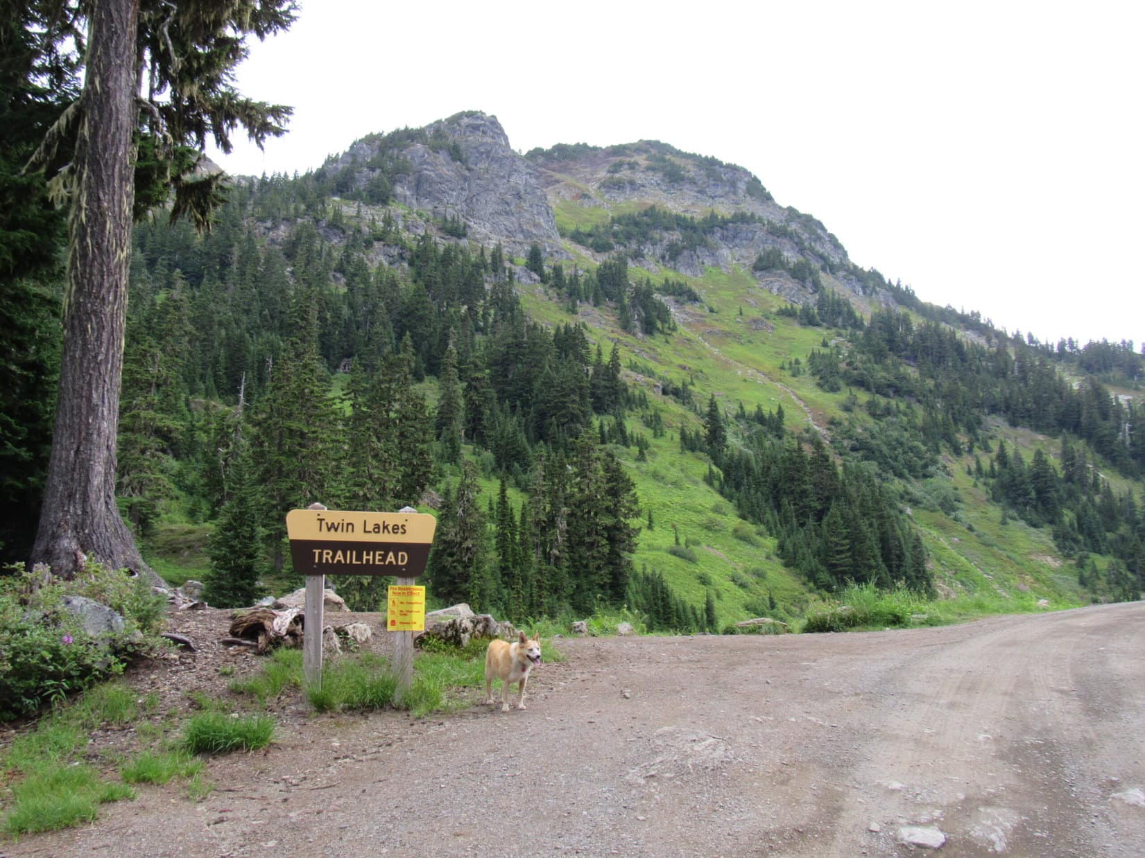
What to do?  After fueling up in Burlington, the day ended with a drive N on I-5 to Bellingham, then E on Hwy 542 back up into the Cascades until a L turn onto USFS Road No. 3065 to Twin Lakes appeared.  Driving up to the Yellow Aster trailhead, SPHP didn’t like the looks of it.  1.5 miles back down No. 3065, a hidden side road dead-ended at a flat spot overlooking Swamp Creek.

Only 70ºF here.  So much better!  Lupe was set for the night.

8-13-21, 7:51 AM, 55ºF, Swamp Creek – Humid, yet smoky.  Definitely worse this morning, but maybe conditions were better higher up, or would improve by the time Lupe could get to Winchester Mountain (6,510 ft.)?  After spending nearly the entire day in the RAV4 yesterday, the American Dingo was at least going to give it a shot.

Leaving the Swamp Creek camp behind, Lupe trotted along the narrow lane leading back to USFS Road No. 3065.  Upon reaching it, she turned R heading NW for Twin Lakes.

End of the lane campsite near Swamp Creek.
On the lane leading back to USFS Road No. 3065.
Twin Lakes Road (USFS Road No. 3065).

A miles long, uphill road hike past Yellow Aster trailhead to Twin Lakes was in store, but the Carolina Dog was happy just being on the move.  Progress was good.  After passing a mile 3 marker, the road leveled out and widened at a small clearing.  On the R was a line of beehive boxes, where plenty of activity was in sight.

Allergic to insect stings, SPHP stayed way over on the L, hoping to slip by without incident.  However, a single bee came flying over, unhappy with the intrusion.  Lupe watched as SPHP repeatedly batted the bee away with a pole.  Increasingly angry, the dang insect kept coming back for more.  A particularly good thwack finally dazed the bee long enough to get past the beehives.

Fortunately, none of the bee’s comrades had felt threatened enough to join in the attack.

Near the dangerous beehives.

Beyond the beehives, Twin Lakes Road resumed its climb.  An amazingly dense forest with thick underbrush lined both sides.  Bushwhacking would be a near impossibility in a steep jungle like this!  Fortunately, no need for that.  Lupe passed several rushing streams that went through culverts.  A view finally opened up where it was possible to see across the valley.  The smoke was discouragingly thick.

Loop was getting close to the Yellow Aster trailhead when she came to a stream that trickled right over the road.  Two Honda Elements appeared on their way down the mountain.  The first one stopped.  A young couple inside said they’d just spent the night up at Twin Lakes.  The smoke was terrible up there now, so bad that it stung the eyes.  Completely ruined their plans, so they were heading home.  And with that cheery tidbit, both Elements were on their way.

Well, fiddlesticks, Loopster!

This is a fail, isn’t it, SPHP?

Yeah.  No doubt about it now.  Worst part of it was that SPHP had to run the beehive gauntlet again.  Sure enough, that same lone deranged bee launched another attack.  Insect brain must have had quite a headache by the time Lupe managed to get by again.

8-13-21, 9:13 AM, Swamp Creek – SPHP turned the key, and the RAV4 sprang to life.

So, what’s the plan?  Where to now, SPHP?

Why bless you, Looper, for thinking that I even have a plan.  About the only thing I can think of is to keep going W.  Maybe out on the Olympic Peninsula skies are blue?  Last bit of continent we have left before total, abject defeat.

Heading W out of the mountains on Hwy 542, SPHP saw a ranger station near Glacier, and stopped to buy a Northwest Forest Annual Pass.  $30.  What a deal!  S of Everett, I-5 was stop and go traffic.  Seattle was a 100°F nightmare, creeping along for hours on end.  Once again, the RAV4’s AC got a workout.  Fortunately, it was up to the task.

Took all day to get around to the S end of the Olympic Peninsula, but at least the air quality was much better.  As night came on, SPHP finally parked the RAV4 at a wide spot along some unmarked USFS Road a few miles N of Wynoochee Lake.

8-14-21 – Like dominoes, one fiasco led to the next.  The plan for the day was to climb Discovery Peak (4,837 ft.).  Not smoky here, but on USFS Road No. 2270 on the way to the trailhead, it became clear that there was a new problem.  The high country was all lost in the clouds.  Not going to see a thing, even if Lupe could manage to climb the mountain.

The American Dingo did get to see a waterfall alongside the road before SPHP gave up and turned the RAV4 around.

The consolation waterfall along USFS Road No. 2270.

On the way out, Loopster might as well have a look at Wynoochee Lake while she was in the area, too.  Due to drought, the lake was low, but it was still in a lovely setting.

Wynoochee Lake.

Since the mountains were clouded over, maybe Lupe could stop at a beach along the Pacific Ocean?  Sounded like fun.  Saturday, though.  Driving N on Hwy 101 all the beaches were packed.  Nowhere to park.  Brief glimpses of the ocean flashed by between the trees.

Aren’t you even going to stop, SPHP?  The Pacific Ocean is right there!  We’re missing it!

Naw.  Too crowded.  Let’s try for Cape Alava, instead!  It’s on the West Coast way up near the N end of the Olympic Peninsula.  Westernmost point of the 48 contiguous US states!  An easy 3 mile boardwalk trail through the rain forest from Ozette Lake will get us to the Pacific, where we can stroll another mile N along a scenic rocky beach to Tskawahyah Island.  Surely, it won’t be so busy.  How does that sound, Loop?

Sounded great, but Ozette Lake was a long winding drive.  At Sekiu, Lupe just had to stop to get up onto a brightly painted rock, and take a look at Vancouver Island across the Strait of Juan de Fuca.

On the dazzling painted rock of Sekiu.
Vancouver Island across the Strait of Juan de Fuca. Photo looks NNE.

Just think, SPHP!  Canada, right over there!

Yep.  Tantalizingly close, Loopster, but still the forbidden land.

8-14-21, 4:16 PM, Ozette Lake, Olympic Peninsula –  Finally, some action!  Expectantly, Lupe stood on the bridge leading to the Cape Alava trail, waiting for SPHP.  Parking hadn’t been a problem, but only because the parking lot was huge.  Must have been more than 100 vehicles present.

Ready for Cape Alava!

Sorry, Loopster, but Cape Alava is out.  We can’t go.

What?  After coming all this way!  Why not, SPHP?

I didn’t even think about this being part of Olympic National Park, Loop.  No Dingoes allowed!

With No Dingo signs everywhere, tons of people around, and a ranger station right at the trailhead, this just wasn’t going to work.  Doomed!

The counter-clockwise journey around the Olympic Peninsula resumed.  A brief stop at the Pillar Point Recreation Area along the Strait of Juan de Fuca was small consolation for the Cape Alava fail, but Lupe did enjoy the rare ocean sniffing.

Pillar Point (Center) along the Strait of Juan de Fuca. Photo looks NNW.

8-14-21, 8:40 PM, Port Townsend – Too late!  Last ferry to Whidbey Island left 10 minutes ago.  Par for the course!  The entire venture around the Olympic Peninsula had been a colossal waste of time and fuel.  Lupe had seen a gazillon trees, but hadn’t climbed any peaks, and had spent hardly any time at the ocean.

Drive clear back through Seattle in the night when the traffic wouldn’t be so bad, or stay here and wait for morning?

Lupe waited.

8-15-21 – Waiting was the right call.  Sunday morning!  Plenty of room on the 6:30 AM ferry.  Cool, and very foggy, so there was absolutely nothing to see, even if Lupe had left the RAV4.

On the ferry.

The Carolina Dog arrived at Whidbey Island without having to endure another long drive through Tacoma and Seattle.  Sunny with clear blue skies by the time she reached Bellingham!  Loopster spent a pleasant morning at Whatcom Falls Park and Whatcom Lake.  In the afternoon, she had to wait in the RAV4 while SPHP dined with Erik, Ana, and their friend, Erin, on the veranda at Anthony’s.

8-16-21, 8:17 AM, 62ºF, Swamp Creek – Lupe was back!  Raining, but only lightly.  At least there wasn’t any smoke.

Well, wha’dya think, Loopster?  Winchester Mountain (6,510 ft.)?  Might get skunked again.

All excited, the were-puppy attacked!

Ack!  Stop!  I’ll take that as a yes.  Onward!  Puppy ho!

This time, no bee dared come out to harass SPHP as Lupe trotted on past the beehives.  The miles long road trek up the side of the Swamp Creek valley wasn’t all that exciting, but eventually there was a great view of Mount Baker (10,781 ft.) back to the SW.

Passing the Tomyhoi/Yellow Aster trailhead. Photo looks NW.
Mount Baker (L) from Twin Lakes Road. Photo looks SW.
Mount Baker with help from the telephoto lens.

The rain had ended well before Mount Baker came into sight, giving rise to hopes that maybe the clouds would dissipate.  However, the situation didn’t change much as Loopster wound her way up 5 long switchbacks.  Meanwhile, across the valley, views of Goat Mountain (6,840 ft.) were steadily improving.

Goat Mountain E (Center) and W (R) summits from the switchbacks. Photo looks S.
Wildflowers along Twin Lakes Road.

At the upper end of the last switchback, the road finally leveled out and curved NE as Lupe reached the Twin Lakes trailhead.  The first lake and Winchester Mountain (6,510 ft.) were now in sight.

Winchester Mountain (Center). Photo looks N.
Near the SW Twin Lake. Photo looks NNE.

The road led over to the area between the Twin Lakes.  Several vehicles and tents were there.  Before passing between the lakes, Lupe climbed a knoll with a view of both lakes and Winchester Mountain beyond them.

Heading over to the area between the lakes. Photo looks NE.
Winchester Mountain (Center) from the knoll. Photo looks NW.
The NE Twin Lake. Pocket Peak (7,056 ft.) (R). Photo looks NE.

After coming down off the knob and passing between the lakes, Lupe reached the start of the Winchester Mountain and High Pass trails.  SPHP paused for a look at the posted map and trail information.

At the actual trailhead.

Seemed simple enough.  Stay to the L where High Pass trail No. 676 splits off, then follow Winchester Mountain trail No. 685 to the lookout at the summit.  Without further ado, Looper was on her way.

Setting out from Twin Lakes. Photo looks S.

Didn’t take long at all to reach a marker at the junction with High Pass trail No. 676.  Winchester Mountain trail No. 685 continued to the L, winding steadily up the mountain’s SE slope.

Marker at the Winchester Mountain and High Pass trails junction.

The easy to only moderately steep trail was in great shape.  Early views included Pocket Peak (7,056 ft.) and Big Bosom Buttes (6,521 ft.) to the E, plus the W summit of Goat Mountain (6,725 ft.) and Mount Baker (10,781 ft.) to the S.

Goat Mountain’s W Peak (L). Photo looks SSW.
Pocket Peak (L) and Big Bosom Buttes (Center & R), along with the NE Twin Lake (R). Photo looks ENE.
Winchester Mountain (R). Photo looks NW.
Mount Baker (L). Photo looks SW.
Mount Baker with help from the telephoto lens.

Blueberries caused some delays.  Absolutely delicious, and the views were better at each stop!  Bear Peak (6,480 ft.) came into sight beyond the Twin Lakes.  Soon Mount Shuksan (9,131 ft.) could be seen between Goat Mountain’s E and W summits.

Big Bosom Buttes (L). Mount Chardonnay and NE Twin Lake (R). Photo looks ESE.
Bear Peak (Center). E & W summits of Goat Mountain (R) with Mount Shuksan in the distance between them. Photo looks S.

Well up on the SE slopes of Winchester Mountain, Trail No. 685 leveled out and turned SW toward a pass next to a big knob of rock along the S ridge.  The only stretch of trail that required any caution was just ahead, a narrow, sloping band of tan rock that led up to the pass.

Trail No. 685 levels out high on Winchester Mountain’s SE slope. Photo looks W.
Approaching the pass (Center) on the S ridge. Photo looks SW.
On the tan rock band, just below the pass.

The tan rock band wasn’t as daunting as it appeared from a distance.  Once up at the pass, the trail curved sharply NW.  A whole new vista was ahead, the rocky shoulder of Winchester Mountain’s SW ridge.  Before continuing on, Lupe paused for a last look down on Twin Lakes.

SPHP was also keeping an eye on Mount Baker, because it seemed to be getting cloudier now.  Unfortunately, the magnificent, glacier-clad peak might not be visible by the time the American Dingo managed to get to Winchester Mountain’s summit.

Twin Lakes from the S pass. Bear Peak (R of Center). E summit of Goat Mountain (far R). Photo looks SE.
Another glance at Mount Baker as more clouds seem to be moving in. Photo looks SW.
Winchester Mountain’s SW ridge. Photo looks NW.

The trail headed toward another pass leading to the SW ridge, but did not go all the way to it, instead switchbacking steadily up Winchester’s SW slope.  Once high enough, Lupe could see Tomyhoi Peak (7,435 ft.) and Mount McGuire (6,588 ft.) beyond the gap.

Higher yet, a dramatic display of American Border Peak (7,994 ft.), plus Mount Larrabee (7,861 ft.) and The Pleiades (7,520 ft.) came into view.

Approaching the W pass (R) to Winchester’s SW ridge (L). The trail did not go all the way to it. Photo looks NNW.
Tomyhoi Peak (Center), Mount McGuire (R). Photo looks NNW.
American Border Peak (L), Mount Larrabee (L of Center), and The Pleiades (R). Photo looks N.

The switchbacks grew shorter and shorter, as Trail No. 685 snaked higher.  Couldn’t be much farther!  Suddenly, a gray building appeared.  The lookout!  Lupe had arrived!

Almost there! Mount Larrabee (L). Winchester summit (R). Photo looks NNE.
By the Winchester Mountain lookout. Photo looks W.

8-16-21, 12:06 PM, 53ºF, Winchester Mountain (6,510 ft.) – A little tan knob of rock a few feet N of the lookout was Winchester Mountain’s true summit.  Claiming her peakbagging success, Lupe visited it briefly, but that wasn’t where the action was.  The big, splendid view was to the N from rock outcroppings ENE of the lookout – Mount Larrabee flanked by the dramatic spire of American Border Peak and rugged Pleiades.

Success! On the true summit. Photo looks NW.
The lookout from the rock outcroppings with the big views. Photo looks WSW.
Canadian Border Peak (7,470 ft.) (far L), American Border Peak (L), and Mount Larrabee (R of Center). Photo looks N.

Too bad it was such a gray day!  Winchester Mountain offered a lot of scenic splendor for a summit with such an easy trail all the way to the top.  A vast sea of glamourous peaks extended in all directions.

No complaints!  At least there wasn’t any smoke for once, and Lupe could see what was out there.  Glancing over at Mount Baker gradually being enveloped in clouds, it was apparent that the Carolina Dog might have reached the top of Winchester Mountain with little time to spare.

I know you’ve earned a chocolate coconut bar and some Taste of the Wild, Looper, but we better get a few photos while we still can!

Final look at Mount Baker (Center) in the midst of its disappearing act. Photo looks SW with help from the telephoto lens.
Mount Baker. Zoomed in even more. Photo looks SW.
Mount Shuksan (Center) between the Goat Mountain peaks. Photo looks S with help from the telephoto lens.
Tomyhoi Peak (L) and Mount McGuire (R). Tomyhoi Lake below. Photo looks NW.

So many magnificent mountains!  SPHP knew the names of only a few.  Happily, a man who had been relaxing in the lookout eventually came out and was able to identify Mount Redoubt (8,969 ft.), which was nearly beyond vision on the far E horizon.

To the SE, snowy Ruth Mountain (7,115 ft.) was lined up directly behind Bear Peak, with Mount Chardonnay (7,020 ft.) closer and farther E.

The Pleiades (L), with countless other inspiring peaks in sight SPHP didn’t recognize. Photo looks NE.
Big Bosom Buttes (Center) in the foreground with Mount Redoubt (L of Center) on the horizon framed between them. Photo looks E with lots of help from the telephoto lens.
Mount Chardonnay (L of Center), Bear Peak (R) with Ruth Mountain (R) beyond. Photo looks SE.

After introductions, SPHP asked Matt Westerheide, if a registry was in the lookout?  Matt said that there was.  So, Lupe got to go inside.  On a small table sat the largest, most elaborate old registry SPHP had ever seen.  Loopster’s name got added, of course!

Matt was very friendly, and happy to meet Lupe and chat with SPHP.  As it turned out, Matt was living the dream!  Since 2018, he had been living out of his van while traveling to many beautiful places between gigs as a contract nurse.  He was a big time skier and kayaker, who did a little mountain climbing, too.  Tonight he intended to stay up here in the Winchester Mountain lookout.

Matt was an incredibly interesting guy.  Upon learning that Lupe hoped to visit Oregon on this Dingo Vacation, he recommended the Trail of Ten Falls in Silver Falls State Park an hour from Portland, and Thor’s Well along the Oregon coast.

With a new friend, adventurer Matt Westerheide, in the snug lookout.
Matt and Lupe.

8-16-21, 3:16 PM, Winchester Mountain – After a long, most entertaining conversation, Lupe and SPHP left Matt to enjoy his stay at the lookout.  Once again, the Carolina Dog stood on the rock outcropping with that splendid view of Mount Larrabee and American Boundary Peak.

Nothing remained.  A cold, damp, gray fog had settled over Winchester Mountain.

Back at the viewpoint.

Well, at least Lupe had arrived in time to see the world earlier on from this beautiful place.  If the weather cleared, she’d get to visit another one tomorrow, a special spot not too far away that was already on her list.  Matt had been there yesterday, and highly recommended it.

Staring briefly into the fog, SPHP sighed, then followed Lupe back down lovely Winchester Mountain.  (End 8-16-21, 6:16 PM, 59ºF, light rain)

On Winchester Mountain, Cascade Range, Washington 8-16-21

Links:

Next Adventure                        Previous Adventure

Want more Lupe adventures?  Choose from Lupe’s Summer of 2021 Dingo Vacations to New Mexico, Wyoming & the West Coast Adventure Index, Dingo Vacations Adventure Index or Master Adventure Index.  Or subscribe free to new Lupe adventures.

Black Hills, SD Expedition No. 293 – Peak 4900 & Peak 5160 (1-28-22)

12:01 PM, 47ºF, start of USFS Road No. 359.3C along Playhouse Road – Wow!  What a gorgeous day!  Didn’t seem like January at all.  Scarcely even any snow around.  Perfect conditions had Lupe out in the hills again.  Her Lists of John mini-blitz was in full swing.  Going around a gate, she headed SE on USFS Road No. 359.3C through a sunlit forest.

About to set out on USFS Road No. 359.3C.

The road descended gradually to a meadow where Loopster made a somewhat unusual discovery.  An old abandoned house was closed off by a pole fence around its perimeter.  Fairly large, it must have been quite the place once upon a time, but was in a sad state of affairs now.

Heading down to the meadow.
By the abandoned house. Photo looks E.

After a good sniff around the house, Lupe returned to the road.  Curving NE, it quickly led to a fork.  SPHP checked the topo map.  Didn’t quite match up with what the Carolina Dog was seeing.

At the fork. USFS Road No. 359.3D goes L. Photo looks E.

Which way, SPHP?

Not entirely sure, Looper.  Think we’re already on USFS Road No. 359.3D, which should get us in a roundabout way close to Peak 4900, if we stay to the L here.  This other road looks like it might go over toward the Spokane Mine, but doesn’t seem to be in the right place.  Should have been a road going that way closer to the house, but I never saw it.

Well, maybe the map is wrong, SPHP?

Yeah, maybe.  Usually I’m the one that’s wrong, though.

Do we have time to go see the Spokane Mine, SPHP?

Oh, I think so.  Shouldn’t be very far.  Want to do that, Loop?

She did.  Taking the road to the R, Lupe slowly gained elevation going ESE up a shallow valley.  The road soon faded to a single track trail.

On the single track. Photo looks ESE.

The trail led up to a fairly level region where more trails headed off in various directions.  Turning S, because that was where the Spokane Mine ought to be, Lupe went over a small rise.  On the other side was a sunny little clearing.  No sign yet of the Spokane Mine, but there was something else.

A grave!

By the mysterious grave. Photo looks SSW.

The lone grave was outlined with rocks.  A flat headstone was so covered with memorabilia that SPHP had to move some of it to reveal the name.

What does it say, SPHP?

James Fernando Shepard.  Says he was born on February 3, 1850, and died on June 21, 1908.  Get this, Loopster!  He was murdered for a mining claim!  This headstone was set in memory from his grandchildren.

Murdered!  For a mining claim!  Must have been for the Spokane Mine, SPHP!  Let’s get out of here!

Silly Dingo!  He was murdered more than 113 years ago.  Nothing to worry about now.  Besides, we don’t have anything to do with any mining claims, for the Spokane Mine, or any other one.

Not taking any chances, SPHP!  Forget the Spokane Mine.  Let’s vamoose!

James Fernando Shepard tombstone.

Slinking E through the forest, Lupe came to another abandoned house.  This one was also large and surrounded by a pole fence, but appeared to be in considerably better shape.

By the second abandoned house. Photo looks NE.

This is giving me the willies, SPHP!  Why all these abandoned homes?

Oh, I don’t know, Loopster.  The mine probably played out, and Spokane became a ghost town.

Ghost town!  We’re in a ghost town?

Well, sort of seems that way, doesn’t it?

What mountain are we going to, anyway, SPHP?

Peak 4900, Loop.  Only 0.25 mile E of here, although we still have a mile to go, if we want to take advantage of USFS Road No. 359.3D.

Well, let’s get there before a ghost comes.  I don’t care what route we take.

Heading N from the second abandoned house, Lupe traveled through open forest and occasional meadows.  Big rock formations could be seen to the E high on Peak 4900’s W slope, which was quite steep.  Eventually a minor pass appeared ahead.  The Carolina Dog went up to it.

Approaching the pass. Photo looks N.

Looked feasible to go E from here, so Lupe kept climbing.  Shortly after the terrain began leveling out she reached USFS Road No. 359.3D again.  The road was fainter up here, but still easy to follow.  It dipped a little, then flattened, as Loop followed it first S, then SE.

At the pass, about to head up the slope. Photo looks ENE.
Back on USFS Road No. 359.3D again.
Following the road SE.

No. 359.3D eventually went by a big field.  Shortly after that, Lupe came to a small clearing where the road appeared to end.  A couple of trails left this point.  Following the one that went straight, it soon disappeared.  By now, Peak 4900’s summit couldn’t be too much farther SW.

Turning W, the American Dingo began climbing again.  The ground started getting rocky as Peak 4900’s N ridge appeared ahead.

The small clearing at the end of USFS Road No. 359.3D. Photo looks S.
Approaching the N ridge. Photo looks SW.

Upon gaining the ridge, Lupe turned S.  The climb was relatively easy.  Soon a high point was directly ahead.

Close to the top. Photo looks S.

1:11 PM, 50ºF, Peak 4900 – Lupe had come up at the NW end of a 400 foot long summit region.  This was the highest part of the mountain.  One of these flat, blocky boulders had to be the true summit, but several were nearly the same elevation.  Hard to say for certain exactly which one was it.

So many trees were around, that views were extremely limited.  To the NW, a narrow look at Mount Rushmore (5,725 ft.) was available from one of the likeliest true summit candidates.  Other than that, a partial view of big forested ridges to the SW was about it.

Peak 4900 summit. Photo looks SSW.
On what might well have been the true summit. Mount Rushmore (L) in the distance. Photo looks NW.
Mount Rushmore with lots of help from the telephoto lens.

Chocolate coconut bar time, SPHP!

As usual, after taking a seat on one of the big rocks, and congratulating Lupe on her successful ascent, SPHP split one with her.

At the short rest break rock. Photo looks N.

Gone in an instant.

Sheesh, Loop.  Do you always have to wolf it down like that?

Dingo it down, you mean, SPHP.  And yes, as a matter of fact, I do!

Whatever.  Guess I sill have all my fingers.  Anyway, see that biggest hill to the SW, Loopster?  I bet that’s Peak 5160, where we’ll be going next.

Don’t rush me, SPHP.  I’m not done with this mountain yet.  We are going to explore Peak 4900’s summit ridge, aren’t we?

Of course!  Ready whenever you are, Loop.

Peak 5160 (R). Photo looks SSW.
Ready to explore Peak 4900’s summit ridge. Photo looks ESE.

SPHP harbored hopes that Peak 4900 had some better viewpoints, but Lupe got all the way to the lower SE end of the summit ridge without catching more than glimpses in this or that direction.  Rocks near the SE end offered limited views of the prairie beyond the Black Hills, but no sweeping panoramas.

A glimpse of the prairie from the SE end of the summit region. Photo looks E.
Western South Dakota prairie beyond the E edge of the Black Hills. Photo looks E with help from the telephoto lens.
Looking SSE.

Pleasant enough, but nothing too amazing.  Ready to head back, Looper?

Soon Lupe was back at Peak 4900’s true summit.  After lingering briefly to admire what views did exist and bask in the Peak 4900 ambience for the last time, the Carolina Dog headed back down the N ridge.

Back at the NW end near the true summit. Photo looks WNW.

This time Lupe explored farther N along the ridge before leaving it for USFS Road No. 359.3D.  Found a nice viewpoint along the way where both Black Elk Peak (7,231 ft.) and Mount Rushmore were in sight.

Black Elk Peak (L), Mount Rushmore (far R). Photo looks NW.

Once on No. 359.3D, Looper stuck with it until the road entered posted private property, which forced a detour.  Lupe wound up wandering so far S on various trails through the forest that she got quite close to the grave again.  From there she retraced her earlier route back to the first abandoned house and No. 359.3C.

Despite this second foray past the ghost town of Spokane, the luck of the Dingo held.  No ghost materialized to haunt her.

On an unmarked trail leading back to the ghost town of Spokane. Photo looks SW.

We didn’t get murdered, either, SPHP!  Made it back to the RAV4 in one piece.  Don’t forget that!

Oh, thanks for the reminder, Loop.  A crucial point!  (End 2:26 PM)

2:35 PM, 47ºF, start of USFS Road No. 753.1A along S Playhouse Road – Having escaped the terrors of Peak 4900, Lupe was ready to take on her second Lists of John peak of the day.  There was another gate to get by, and beyond it was a road less traveled.  A mere grassy lane, USFS Road No. 753.1A turned S just past the gate.

By the gate at the start of USFS Road No. 753.1A. Photo looks SE.
On the road less traveled. Photo looks SSE.

Loop had barely gotten started on No. 753.1A, when No. 753.1B branched off to the E.  That was the way to Peak 5160, but the road didn’t look all that promising.  A short distance from No. 753.1A, No. 753.1B was choked with deadfall as it curved SE entering a narrow, shaded valley.

On USFS Road No. 753.1B after getting past the deadfall. Photo looks SE.
Continuing up the narrow valley. Photo looks SE.

After almost 0.25 mile, the valley broadened out.  The road was fainter here.  If not for the topo map, SPHP wouldn’t even have realized that there was a fork.  USFS Road No. 753.1C branched off to the NE (L), going up a sunlit hillside.  No. 753.1B turned S (R), continuing up the valley.

USFS Road No. 753.1B continues almost straight ahead here, but slightly to the R.

The Carolina Dog stuck with No. 753.1B, which improved and started to climb more aggressively.  Soon there were glimpses of towering granite formations off to the E.  Kind of a red flag!  Although a bit farther S, Peak 5160 was in that general direction.  If it looked like that, Lupe was never going to be able to get to the top.

Yikes! Peak 5160 better not look like that! Photo looks E.

A gate in a wire mesh fence was ahead.  Would have been a problem, since the gate was locked, but a gap near one of the posts allowed Lupe to slip through.

Think we’re in Custer State Park now, Looper.

Gate at the N boundary of Custer State Park. Photo looks S.

No. 753.1B continued higher, but was looking like it would soon level out.  The road curved SSE, then W, as Lupe neared a sunlit ridge.  Near a saddle, the road forked again.  One branch went back to the NNW, the other continued S over the saddle, and on down into another valley.

More big granite formations were in this region.

Approaching the sunlit ridge. Photo looks S.
More rock formations ahead. Photo looks SSE.
At the saddle. Photo looks SSE.

A massive rock formation SE of the saddle was concerning.  Even if it wasn’t the true summit of Peak 5160, it might well be an indication of what to expect.  A check of the topo map showed the summit NE of here.  Oddly enough, it also showed USFS Road No. 753.1B dead-ending.  None of these other branches of the road appeared on the map.

No choice, but to press on.  Leaving the saddle, and all of the roads, Lupe passed N of the enormous granite formation heading E.  Surprising SPHP, she soon came to a wide, forested ramp leading higher.

Heading up the lovely ramp. Photo looks ENE.

Oh, yeah!  The news got even better!  At the upper end of the ramp, Lupe came to a grassy field.  Off to the NNE, it slanted up to an obvious high point, right where Peak 5160’s summit was supposed to be.

Nothing to it, SPHP!  We’ll be there in just a couple of minutes!

Almost there! Photo looks NNE.

3:32 PM, 45ºF, Peak 5160 –  And so it was.  A quick trek to the top, and there was Loopster, poised on the very highest rock.

Peak 5160 summit. Photo looks NNE.

Hah!  Knock me over with a feather, Looper!  Thought we were doomed!

Duck soup, SPHP!  About time for another chocolate coconut bar, isn’t it?

That it was.  Rather rocky up on this little ridge, but SPHP found a spot to sit down.  Lupe curled up on SPHP’s lap.

The views were very nice!  Nothing to the E was as high as Peak 5160.  Lupe could see way out to the prairie beyond the Black Hills, a genuine panorama this time, not merely a glimpse.  Peak 4900 was in sight off to the NE, but looked like a mere twerp of a hill from here.  Due N on the horizon, Silver Mountain (5,405 ft.), Boulder Hill (5,331 ft.) and Storm Hill (5,192 ft.) were all on display.

The distant prairie panorama. Photo looks E.
Peak 4900 (R). Photo looks NNE.
Silver Mountain, Boulder Hill and Storm Hill on the horizon. Photo looks N.
Silver Mountain (L), Boulder Hill (Center) and Storm Hill (R). Photo looks N with help from the telephoto lens.

The chocolate coconut bar vanished in an instant.  SPHP offered Lupe some Taste of the Wild, but she didn’t seem interested until a helicopter appeared, flying this way out of the SW.  At that point, Loopster gobbled all the Taste of the Wild down as quick as she could so the helicopter wouldn’t steal it, a maneuver which worked brilliantly.  The famished helicopter flew away, cruelly disappointed.

Careful examination of the topo map showed two more tiny 5,160 foot contours along the ridge Peak 5160 was part of.  Lupe was where Lists of John showed the true summit, but was that really the case?

The most distant of the competing contours represented the top of a hill visible 0.5 mile SSE.  From here, that hill looked definitely lower.

SPHP judged the competing high point (R of Center) definitely lower. Photo looks SSE.

However, the second tiny contour represented the top of the massive rock formation that Lupe had gone by on the way up.  Trees hid the high point over that way from the summit where Lupe was, but it was visible from only a little way down the S slope.

The competing rock formation (R) from a little way down the S slope. Photo looks S.
Another look from a little farther down the slope with help from the telephoto lens.

Hmm.  I don’t know, Looper.  Mighty close call!  In fact, if I had to put money on it, think I’d bet on that rock formation being the true summit.

Maybe so, SPHP, but that’s rock climber territory.  We’ll never get up there!

Yeah, sure looked that way.  Not even going to attempt it.  Completely kosher or not, this was good enough for Dingo work.  Lupe was claiming her second Lists of John success of the day!

Nearly an hour after arriving, Loopster was on her way back down the ramp.  Upon reaching the roads over at the saddle near the problematic rock formation, she took a little time to sniff around exploring among the big rocks near its base.  This was pretty cool territory!  Might be fun to come back sometime for another look around.

Heading down the ramp. Photo looks W.
Below the massive rock formation. Photo looks ESE.
More interesting territory in the area. Photo looks S.

But the sun was almost down, and the Carolina Dog ought to be, too.  After a little fun among the big rocks, she returned to the saddle.  This time, instead of taking USFS Road No. 753.1B again, Lupe explored the road going NNW.

Taking an alternate, unmarked route back. Photo looks NW.

The road soon wrapped around the end of the ridge.  Curving W, it started a steep descent.

Heading down. Photo looks WSW.

SPHP suspected this route might ultimately lead back to USFS Road No. 753.1A again, but it didn’t.  Instead, Lupe reached S Playhouse Road 150 feet S of the N boundary of Custer State Park.  An easy downhill trek along the paved road was all that remained.

Two more peaks climbed!  No ghosts, and didn’t get murdered!  Lupe’s Lists of John mini-blitz was going well.  Little did the American Dingo suspect that it would all come to an end tomorrow.  (5:05 PM, 36ºF)

Peak 5160, Black Hills of South Dakota 1-28-22

Links:

Next Black Hills Expedition                     Prior Black Hills Expedition

Want more Lupe adventures?  Check out Lupe’s Black Hills, SD & WY Expeditions Adventure Index, Master Adventure Index, or subscribe free to new Lupe adventures!