Start: Hwy 87/89, 0.25 mile NW of Sylvan Lake Lodge, 9:46 AM, 46°F
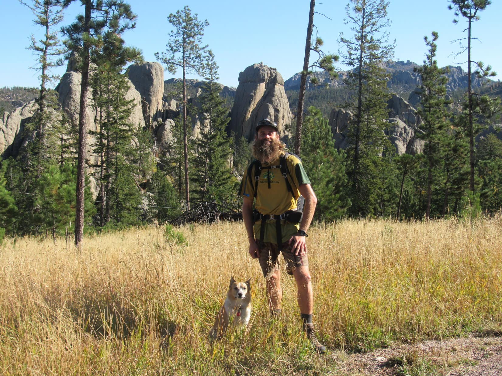
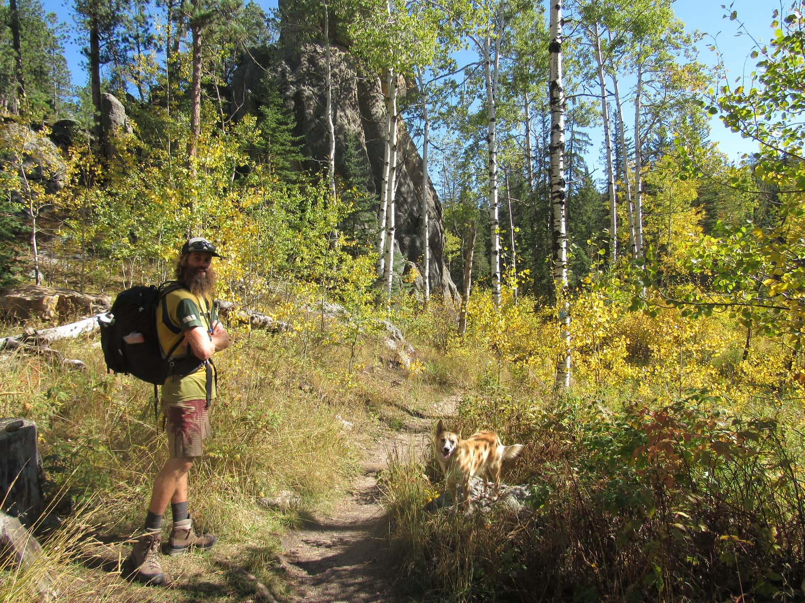
Wonder of wonders! Australian adventurer Luke Hall was actually here – in Lupe’s Black Hills of South Dakota! He’d arrived yesterday afternoon only a few weeks from the end of a 6 month trip exploring the western United States.
During his recent travels, Luke had scrambled up many notable mountain peaks, including Mt. Whitney(14,498 ft.) in California and Mt. Elbert(14,433 ft.) in Colorado, the two highest mountains in the lower 48 states. He’d spent a lot of time along the Pacific coast, and visited a great many national parks – Yosemite, Death Valley, Sequoia, King’s Canyon, Grand Canyon, Zion, Bryce, Mesa Verde, Mt. St. Helens, Mt. Rainier, Rocky Mountain – the list went on and on.
Surfing, swimming, backpacking, mountain biking, climbing – Luke had been a busy guy in 2017, but that was perfectly normal for him. In previous years, he’d explored western Canada, 10 different countries in South America, wandered through much of Europe, and toured Morocco and Egypt. He spent 2 years living and working in London, England, and another 2 years in Banff, Canada. Maybe it wasn’t so surprising that Luke had finally landed in the remote Black Hills of South Dakota after all? He did get around!
Fittingly enough, Lupe and SPHP had first met Luke Hall over a year ago on Gunsight Mountain(6,441 ft.) in Alaska. Now Luke was here to join Lupe on one of her Black Hills, SD expeditions. He had already dropped by Mt. Rushmore(5,725 ft.) on his way in, so Black Elk Peak(7,231 ft.), the highest mountain in South Dakota, seemed like a good destination. For Luke it would be an easy day, but maybe he wouldn’t mind dialing it down a notch after 5+ solid months of more strenuous adventures?
It was a lovely bright, clear day as Lupe, Luke and SPHP set out. First stop along the way was Sylvan Lake.
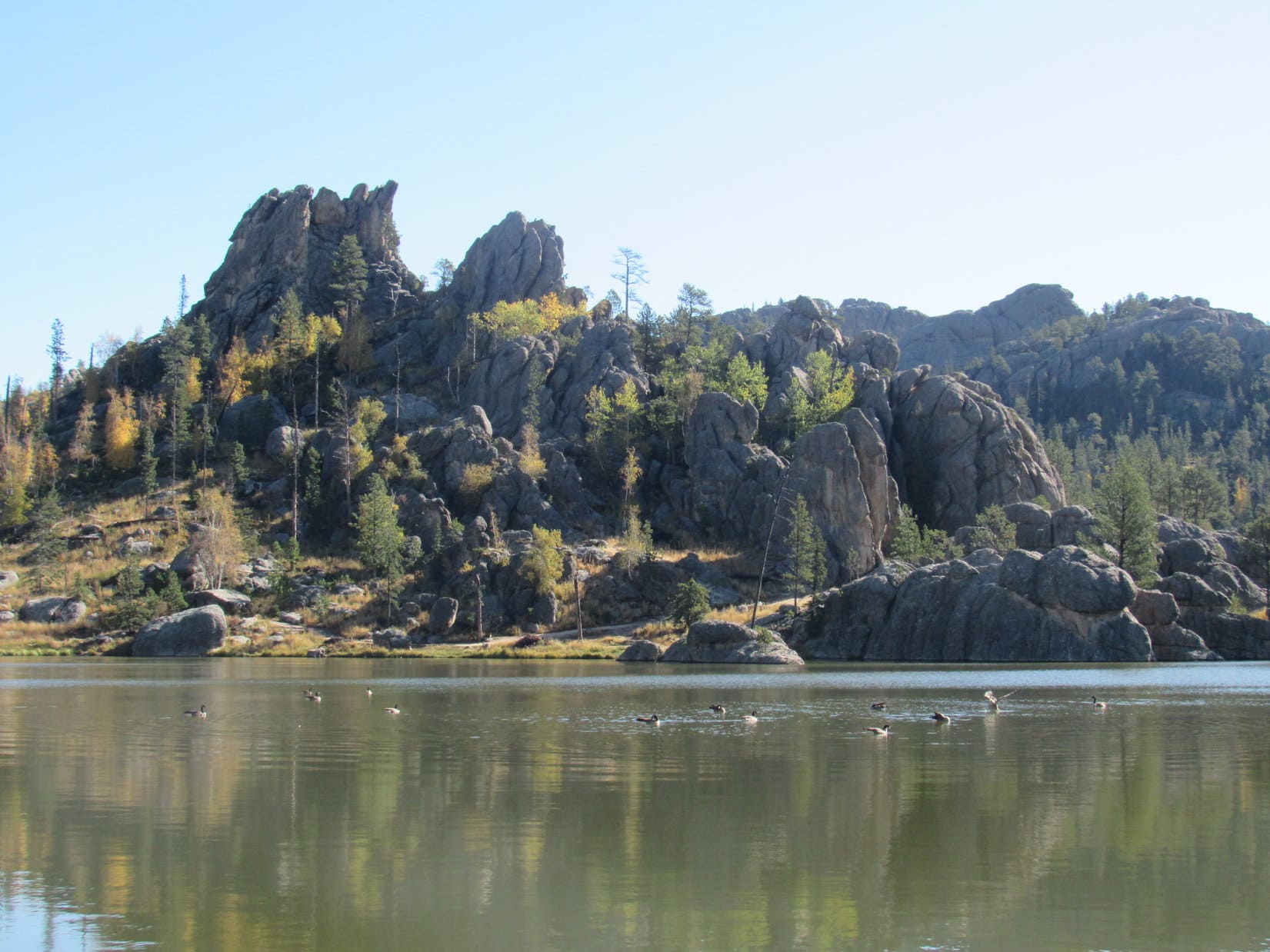
Lupe and Luke together again in the Black Hills for the first time since meeting over a year ago on Gunsight Mountain(6,441 ft.) in Alaska. Black Elk Peak, the highest mountain in South Dakota was today’s ultimate destination. Photo looks E.Only 10 or 15 minutes after setting out, Luke and Lupe reach the NW shore of Sylvan Lake.The small dam creating Sylvan Lake, which features a short walkway with a railing, is seen beyond Luke. Photo looks N.Looking NE across the lake.A few ducks were out on the calm water.
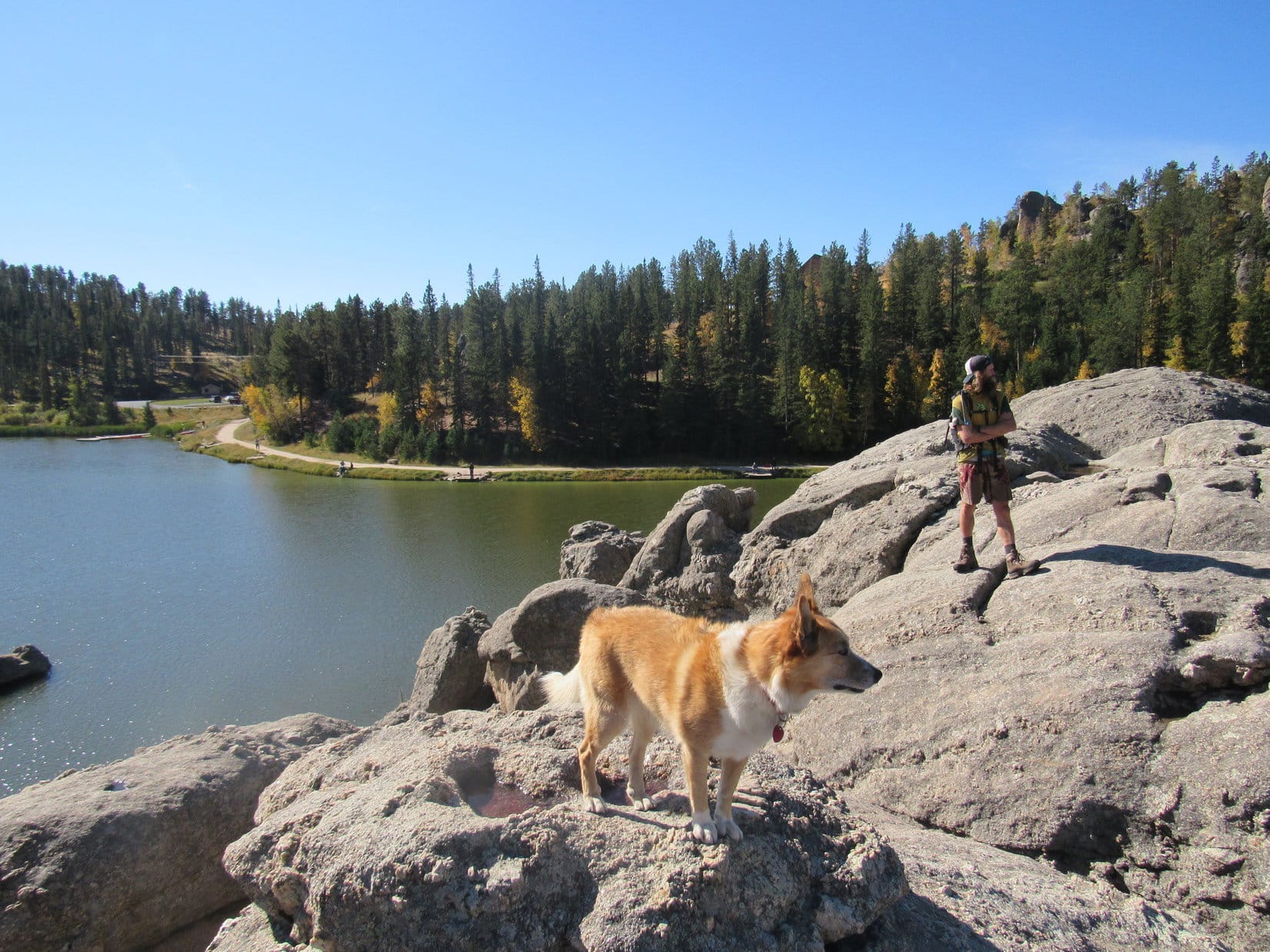
After a look at Sylvan Lake from the NW shore, Lupe, Luke & SPHP followed a trail that goes all the way around the lake back down below the dam. Lupe led Luke around to the NE & E sides of the lake.
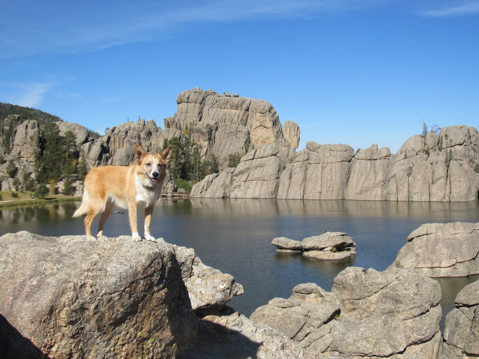
Looking SW from the rock formations along the N shore.Sylvan Lake is located at the far NW corner of Custer State Park. Though small, the lake nestles among scenic granite formations. It’s a popular destination for tourists and locals alike with a swimming beach and picnic ground. Paddle boat rentals, a convenience store and Sylvan Lake Lodge are all nearby. Photo looks W.Lupe showing her buddy Luke around Sylvan Lake. Photo looks WNW.Loopster and Luke on a large granite formation that extends out into Sylvan Lake from the E shore. Photo looks SW.Looking NNW at the N half of Sylvan Lake.
Trail No. 9 from Sylvan Lake is the most direct and popular route to Black Elk Peak, but Lupe had another trail in mind. She led Luke past the picnic ground at the SE end of the lake, and took Trail No. 4 to the Little Devil’s Tower trailhead instead.
Taking Trail No. 4 was a longer route to Black Elk Peak, but had the advantage of giving Luke a chance to climb Little Devil’s Tower(6,960 ft.) along the way, and get a close look at the Cathedral Spires(6,840 ft.), too.
Luke & Lupe along Trail No. 4 to Little Devil’s Tower.A 0.25 mile long spur trail off Trail No. 4 leads to the summit of Little Devil’s Tower. Here Lupe is near the spur trail with a view of the Cathedral Spires. Photo looks E.Luke & Looper on the way to Little Devil’s Tower. Cathedral Spires in the background. Photo looks E.
A 0.25 mile long spur trail leads from Trail No. 4 to the summit of Little Devil’s Tower. The end of the route involves a quick, easy scramble up the granite. Even small children can make it with a little supervision and an occasional boost.
Luke & Loop nearing the top of Little Devil’s Tower. Photo looks N.
Luke, Lupe and SPHP quickly arrived at the summit of Little Devil’s Tower(6,960 ft.). There were cliffs around, especially to the N, but they were of no concern. Although a bit rough, the uneven granite summit area is quite roomy.
The 360° views from Little Devil’s Tower are among the best in the Black Hills, with Black Elk Peak(7,231 ft.) to the NNW and the Cathedral Spires(6,840 ft.) to the SE being the most eye-catching.
Luke and Loopster arrive at the uneven granite summit of Little Devil’s Tower. Photo looks ESE.Another view with some of the Cathedral Spires (also known as the Needles) in the background. Photo looks ESE.Lupe with the Cathedral Spires in the background. This was Lupe’s 5th ascent of Little Devil’s Tower. Photo looks SE.Although the day had started out clear and bright, quite a few clouds were around by the time Lupe reached the top of Little Devil’s Tower. A chill breeze was blowing out of the S, too. Photo looks SE.Looking NNW toward Black Elk Peak. For those with insufficient time to climb Black Elk Peak, the shorter trip on Trail No. 4 up to the top of Little Devil’s Tower can provide similarly striking views of the Black Hills.Sylvan Hill(7,000 ft.) is the long ridge 2.5 miles away with the high point poking up just R of Center. Photo looks WSW.
At first, no one else was around up on Little Devil’s Tower. It wasn’t long, though, before a couple appeared. Bryan and Rene Jobo from Franklin, Tennessee joined Lupe, Luke and SPHP at the summit.
Rene and Bryan were on vacation in the Black Hills, and apparently having a good time relaxing and hitting some of the area’s highlights. Bryan, Rene, Luke and SPHP were soon chatting pleasantly. Lupe got involved posing for photos.
Australian adventurer Luke Hall poses with Bryan & Rene Jobo from Franklin, TN up on Little Devil’s Tower. Photo looks SE.Despite a cool SW breeze, Lupe wasn’t about to get left out. Here she poses with Bryan & Rene, too.In addition to posing with an American Dingo up on Little Devil’s Tower while in the Black Hills, Bryan & Rene were looking forward to attending the Custer State Park annual buffalo roundup in a couple more days. Lupe would have loved to go to help herd buffalo around, too. Unfortunately, SPHP never seems to think that a huge buffalo herd will appreciate a noisy Dingo, so Lupe has never gotten to go.
Bryan and Rene stayed chatting with Luke and SPHP for a while, but didn’t have time to accompany Lupe all the way to Black Elk Peak. They had other adventures in mind to press on toward. Soon after Bryan and Rene said good-bye; Luke, Lupe and SPHP resumed the trek to Black Elk Peak.
Luke near the Cathedral Spires on the way back to Trail No. 4 to resume the trek to Black Elk Peak. Photo looks E.
Trail No. 4 went N past some of the Cathedral Spires, and eventually linked up with a short section of Trail No. 3, which led in turn to Trail No. 9. Near the end of a spur trail off Trail No. 9, a metal stairway hidden in a narrow opening in the granite spiraled up to a rock stairway leading to the old fire lookout tower on Black Elk Peak(7,231 ft.).
Luke reaches the old fire lookout tower at the summit of Black Elk Peak. Photo looks N.Until August 11, 2016 when the U.S. Board of Geographic Names voted unanimously in favor of the name Black Elk Peak, the highest mountain in South Dakota had been known as Harney Peak. Luke poses by a plaque at the lookout tower which has not been updated yet. In May, 2015, the South Dakota State Board of Geographic Names had proposed renaming the mountain Hinhan Kaga (Making of Owls), but that recommendation was never enacted. Lupe would have preferred Squirrel Mountain, or at least Chipmunk Mountain, but, oh well!Looking ENE from the Black Elk Peak summit. The most distant big square block of granite at Center is the back side of Mt. Rushmore.
Upon arrival at South Dakota’s highest point, Luke, Lupe and SPHP spent a few minutes out on the fire lookout tower’s W facing observation deck taking in the views. The wind had shifted to the NW by now, though, and was even colder than at Little Devil’s Tower.
View to the NNW from the fire lookout tower observation deck on Black Elk Peak.
Even Lupe was soon ready to retreat back into the lookout tower. The tower wasn’t very large inside, but Luke enjoyed exploring the winding passage down to the basement. An open doorway led out to a massive granite shoulder of the mountain immediately W of the tower. Everyone enjoyed a break in the shelter of a few pines growing out of the rock.
After snacks and water, it was time for photos from various points on the granite near the lookout tower.
Luke and Lupe NW of the fire lookout tower. The tower was last staffed in 1967. Made of stone, it has held up remarkably well during the ensuing 50 years, despite the efforts of any huffing and puffing big, bad Dingoes. Photo looks SE.Luke & Lupe up on rocks N of the tower. Photo looks NE.Adventure buddies Lupe and LukeLupe on Black Elk Peak. This was her 7th visit to the mountain. Her last visit was over 2 years ago on 9-7-15. Back then the mountain was still officially Harney Peak, as it had been since 1896. Photo looks W.Helicopters giving tours of the Mt. Rushmore area often make a pass around Black Elk Peak. Lupe loves barking at helicopters! She’s spotted one now!The view to the SE.Cathedral Spires (L) and Little Devil’s Tower (R) are in view beyond Lupe & Luke. Photo looks S.Black Elk Peak was Luke’s 3rd US State high point after Mt. Whitney in California and Mt. Elbert in Colorado. Photo looks S.
All too soon, it was time to depart. On the way back to the G6, Lupe, Luke and SPHP followed Trail No. 9 all way to Sylvan Lake. The sun was sinking, but down out of the wind the evening was pleasant.
Starting down. Sylvan Hill is seen in the distance. Photo looks SW.On Trail No. 9 before the junction leading to Little Devil’s Tower (R). On the return trip Luke & Lupe stuck with Trail No. 9 all the way, the most direct route back to Sylvan Lake. Photo looks SSW.Little Devil’s Tower from Trail No. 9. Luke & Loopster had been up there only a few hours ago! Photo looks SW.A view to the NW from Trail No. 9.Loop & Luke at the last big viewpoint along Trail No. 9 on the way to Sylvan Lake. Photo looks NNE.Australian adventurer extraordinaire Luke Hall presents the Black Hills of South Dakota!Looper takes a break on a lovely bench provided by the Highpointers Foundation. This bench is along Trail No. 9 at the first good viewpoint toward Black Elk Peak (formerly Harney Peak) on the way up from Sylvan Lake.
The light was fading fast by the time Lupe reached the G6 again at 6:45 PM (upper 50’s °F). Climbing mountains with Luke, and getting to show off her Black Hills home territory had been great fun!
The fun wasn’t over yet, though. There would be pizza and beer with Luke at home. (What, no beer for the faithful, peakbagging Carolina Dog!? No fair!) Even better, Luke was sticking around for a while. Another adventure was in store tomorrow.
It just doesn’t get any better than that!
Adventurer Luke Hall originally hails from Sydney, Australia. Lupe & SPHP were thrilled that he took the time to come pay a visit to the beautiful Black Hills of western South Dakota!Adventuring buddies Luke & Lupe on Black Elk Peak, 9-26-17
There’s nothing so rare as a day in June, and June had just arrived! Both Lupe and SPHP were raring to go, even though scattered thunderstorms were in the afternoon forecast. The plan was to head way out into the high country of the NW Black Hills for some peakbagging fun. First up were Peak 6888 and the Bald Hills(6,690 ft.), both within a few miles of the Wyoming border.
Although there were already clouds around, the sun was still shining when SPHP parked the G6 more than 0.5 mile W of County Road No. 117 along USFS Road No. 109 (Parmlee Canyon Road) at 9:39 AM (59°F). Lupe and SPHP started out taking Bear Canyon Road S from No. 109. Bear Canyon Road was just a dirt road that looked like it seldom gets any traffic. It passed through a field in a shallow valley and then entered the forest, winding its way up a low ridge at a pretty decent clip.
The climb was a short one. Bear Canyon Road soon leveled out, and reached a clearing where there was an intersection with more faint roads. Several whitetail deer ran off into the forest as Lupe approached the intersection. Peak 6888 is about 0.75 mile S of Parmlee Canyon Road. SPHP figured Lupe still had to go a bit farther S to get there. The road continuing S was marked as USFS Road No. 117.5J.
Lupe followed No. 117.5J up a couple of little rises. The road leveled out again after each one. When the road seemed to be at its highest point, SPHP stopped to check the topo map. The summit of Peak 6888 was supposed to be a little W of the road. The entire area looked quite level, although the forest did look a bit higher off to the NW. Lupe and SPHP left the road exploring the forest to the NW, while searching for an obvious high point or marker.
Lupe found neither. A big area was almost as flat as a pancake. Nothing seemed discernably higher or lower than anywhere else. Lupe saw more deer, but summits were scarce. Well, Loop, looks like this is all the summit! SPHP encouraged Lupe to hop up onto a big log. This can be your summit photo, Lupe! Might as well call it good, and go on to the Bald Hills.
Lupe seemed happy enough to call this log the summit of Peak 6888. There were no views in any direction, just more flat forest extending all around.
Peak 6888 was now in Lupe’s bag, but it hadn’t been too exciting. At least there was a little excitement when Lupe and SPHP returned to No. 117.5J. Lupe saw a female elk crossing the road. The elk saw Lupe and SPHP, too. It took off running, but seemed confused on which way it wanted to go. It finally disappeared off to the SE.
Lupe and SPHP continued S on No. 117.5J. Almost right away, Lupe came to a big square mud puddle where the road started angling SW. Lupe ran over to wade around and get a big drink of mineral water.
Lupe discovers the mineral water puddle on Peak 6888.The mineral water puddle looked like it could have been milk chocolate flavored.
From the milk chocolate colored mineral water puddle, No. 117.5J started losing elevation slowly, but steadily, as it went SW for about 0.75 mile. The road appeared to end in a small valley near a couple of stock ponds. There were several barbed wire fences in the area. Lupe and SPHP headed S across the little valley, and climbed up the next low ridge ahead. Up on top, Lupe found USFS Road No. 113 at a green gate.
By now the sky was completely overcast, and it began to rain steadily. SPHP wore a blue plastic rain poncho, but Lupe was doomed to become a progressively more soggy doggie. Lupe and SPHP marched W on No. 113 in the mud and rain. The clouds grew darker. The downpour strengthened, and the woods filled with fog.
Although Lupe ordinarily loves to get wet playing with the garden hose on warm, sunny days, the dreary downpour seemed to dampen her spirits. For 2 miles, Lupe and SPHP slogged W on No. 113. SPHP began to wonder what ever happened to the “scattered” part of the scattered T-storms in the forecast. It looked like it could rain buckets all day.
After going 2 miles, Lupe started passing by minor side roads that SPHP was expecting to see, and No. 113 gradually turned S. The road had been fairly level most of the time, but now began to lose some elevation. That didn’t last long. It was soon gaining the elevation back. Lupe reached a high spot on the road as it turned W. The road continued W, but it was clear it was about to lose serious elevation in that direction.
About this time, the rain stopped. Suddenly the sky was getting brighter again. SPHP stopped to check the maps. The little green hill on the N side of the road had to be the summit of Bald Hills. Lupe was practically there!
The remains of a campfire were on the N side of the road, too. Unfortunately, trash was scattered all around it. While SPHP collected trash, Lupe sniffed around, encouraged by the rapidly clearing sky.
Lupe just S of the summit of Bald Hills. The top was just up this little green hill. Photo looks N.A rather damp Lupe among pretty yellow flowers S of the summit of Bald Hills.
When the trash was all gathered up, Lupe and SPHP climbed the little green hill to the summit. The summit area was a bit surprising. It was a big flat open field, completely surrounded by pine trees.
Trees killed by pine bark beetles were still standing along the W edge of the meadow. When they eventually fall over, the view will improve dramatically. As it was, Lupe and SPHP could only get glimpses of Mount Pisgah(6,380 ft.) five miles away in Wyoming.
Lupe in the big flat meadow at the summit of Bald Hills. Photo looks W. The sky is beginning to clear!Looking W.Lupe starting to dry out in the sunshine. Photo looks NE.
The meadow on Bald Hills was quite pretty and full of little flowers. It was kind of a shame there wasn’t a more open view anywhere, but that’s the way it was. As Lupe and SPHP ambled around the field, the last of the storm clouds drifted away to the E, and the sun began to shine.
Lupe and SPHP left the summit taking what was supposed to be a shortcut back to No. 113 by heading directly E. There proved to be a fair amount of deadfall timber to deal with in the forest. While Lupe might have saved some distance, it was debatable how much time was really saved.
Once on No. 113 again, Lupe and SPHP followed it back E. Where dark clouds, rain and fog had prevailed only a short time ago, now a sunny, fresh, bright green Dingo Paradise existed. Lupe’s spirits soared! She dashed through the damp woods sniffing excitedly at every tree and bush. Lupe came to a series of small pools scooped out along the road. She made frequent use of them.
One of several pools of rainwater along USFS Road No. 113. The day was warming up rapidly. Lupe made frequent quick stops at the pools for refreshing drinks.
When Lupe reached the green gate across No. 113 again, she turned N leaving the road. Lupe and SPHP went down off the ridge into the small valley, this time passing above (E of) the higher pond. Lupe returned to No. 117.5J. Soon Lupe and SPHP were back up on Peak 6888 again.
Lupe took a Taste of the Wild break while resting under a fallen tree trunk. SPHP sat on the tree trunk eating an apple and looking at the maps. After the break, Lupe and SPHP once again wandered around on Peak 6888, still looking for an obvious high point, but with the same negative results. Lupe chose a bright green meadow for her 2nd Peak 6888 summit shot of the day.
Lupe near the upper pond on her way back to Peak 6888. This area is a little W of the Beaver Creek Cow Camp on the USFS map.Lupe takes a Taste of the Wild break while resting under a fallen tree on Peak 6888.Lupe chose this bright green meadow to commemorate her 2nd ascent of Peak 6888 of the day. Photo looks WSW.
SPHP had noticed while looking at the maps that 0.33 mile to the NE of Peak 6888 there was a small area enclosed by a 6,900 foot contour line. Since that was somewhat higher ground, Lupe and SPHP crossed over No. 117.5J to go check it out.
NE of No. 117.5J, Lupe did seem to gain a little elevation, but it didn’t amount to much. Lupe still found no obvious high point. There weren’t any big views anywhere over here either, just more forest. Lupe and SPHP went W back to Bear Canyon Road and turned N. By 1:48 PM (65°F), Lupe was back at the G6.
Lupe’s next two peakbagging goals were both located 10 miles to the NNW. Lupe and SPHP jumped in the G6, and enjoyed a very scenic drive through gorgeous Black Hills high country near the Wyoming border. The last part of the drive was along another USFS Road No. 109. (Not the No. 109 that leads to Parmlee Canyon.) This No. 109 led N out of the Beaver Creek valley. It eventually turned NW toward the Wyoming border.
SPHP was really hoping there would be some kind of a sign and a fence at the border. Lupe’s third peakbagging goal of the day was the Weston County, Wyoming High Point(6,620 ft.). The high point is located about 0.375 mile S of where No. 109 reaches the Wyoming border. The whole key to finding the Weston County High Point was knowing where the border was.
The luck of the Dingo prevailed! There was a Wyoming sign at the border. There was also a cattle guard, a fence, and a convenient level place to park on the South Dakota side (2:28 PM, 57°F). Lupe and SPHP left the G6, crossed the cattle guard into Wyoming, and headed S along the border fence.
The entire area was forested and rolling, but without significant elevation changes. Logging trails ran this way and that through the woods. When it seemed easier, Lupe and SPHP just followed the logging trails, but never got very far from the border fence. Pretty soon, Lupe came to two high points right along the state line. One of them had to be the Weston County High Point.
The two high points were close enough to each other so it was possible to see both at the same time. However, they were so similar in elevation, SPHP wasn’t certain which was truly the highest point. The first one Lupe came to, the one to the N, seemed like it was highest, but it was hard to tell for sure. Naturally, Lupe visited both high points.
Lupe at the N candidate for the Weston County, WY high point. She is sitting just past the border fence on the South Dakota side of the border. SPHP believes this is the true high point, but there was another possible candidate in view a short distance to the S. Photo looks E.
From the N high point, a small, nearly level ridge extended W about 100 feet into Wyoming. It was possible the Weston County High Point was actually somewhere along this ridge instead of right on the border with South Dakota. Lupe explored the W ridge out to where it ended at 10 foot high limestone outcroppings. SPHP was of the opinion the actual high point was back at the WY/SD border, rather than anywhere along the ridge.
Lupe seemed to enjoy looking for the Weston County High Point. Here she is looking happy while exploring the small ridge W of the border and the N high point candidate.Although Lupe explored this entire ridge W of the N candidate on the WY/SD border for Weston County, WY High Point, SPHP didn’t believe the actual high point was anywhere out on this ridge. To SPHP, the land seemed marginally higher right at the border. Lupe never did really come out and say what she thought.The W end of the ridge ended at these 10 foot high limestone outcroppings. Photo looks SE.
After exploring the W ridge, Lupe and SPHP went over to the S high point candidate along the Wyoming/South Dakota border. A small area on the Wyoming side near the S high point had been clear cut. There were slash piles laying all around. The S high point was a limestone outcropping right at the border. There wasn’t any ridge extending out to the W here. The ground went downhill immediately W of the high point.
Lupe at the S candidate along the WY/SD border for Weston County, WY High Point. Photo looks S.
Wherever the actual Weston County High Point truly was, Lupe had now been there, having explored both possible candidates, plus the W ridge. The forest blocked any views, so there was no reason to linger. A short distance up a little hill to the E just inside the South Dakota border was Lupe’s fourth peakbagging goal of the day, Peak 6645.
Why Peak 6645 is on Peakbagger.com’s official list of Black Hills 6500-foot Peaks is completely beyond SPHP. There are numerous other higher points close at hand that are not on the official list. A little over 0.1 mile to the NE is High Point 6651, a mile to the SE is High Point 6807, and a little farther E is High Point 6906. The topo map shows many other examples of higher points close at hand, too. Nevertheless, Peak 6645 is on the official list and the others aren’t.
Since Peak 6645 was on the official Black Hills 6500-foot Peaks list, Lupe was going to visit it. At least it had the great virtue of being located very conveniently close to the Weston County, WY High Point. Lupe and SPHP made the short trek up the hill. Between the trees was a hint of a view off to the WSW, but that was all. Nevertheless, Lupe seemed completely happy with Peak 6645.
One cheerful Carolina Dog on Peak 6645! Photo looks WSW at a little meadow. Lupe is about 30 feet W of the actual highest point on the hill, but it was only 4 or 5 feet higher than where she is here.
Lupe on the very highest part of Peak 6645. Photo looks NE.
The actual summit of Peak 6645 was an otherwise unremarkable 5 foot high mound in the woods. Lupe sniffed around for a couple of minutes, but even she didn’t find anything particularly fascinating. While Lupe was sniffing around, clouds were moving in again. Thunder started rumbling off to the NW. Lupe and SPHP hurried NE on to High Point 6651.
From High Point 6651, Lupe was able to see USFS Road No. 109 just below to the NE. Instead of going right on down to the road, though, Lupe and SPHP turned NW, following the ridge. The ridge soon played out, and sloped on down to No. 109 closer to the G6. A quick 0.25 mile road trek, and Lupe was back at the G6 (3:17 PM, 57°F).
Hwy 85 near Buckhorn was only a couple of miles NW on USFS Road No. 809 (the road number changes from No. 109 at the Wyoming border), but it was already raining again by the time Lupe reached the highway. Another thunderstorm was passing through. SPHP stopped in at the Buckhorn Bar & Grill to grab a hamburger. Lupe stayed in the G6, entertained by barking at black cows across the road.
Lupe sniffs around outside the Buckhorn, WY Bar & Grill.
The owner and the cook/waitress were the only people in the Buckhorn Bar & Grill. They were both friendly, and after a reasonable delay produced a pathetic-looking over-priced hamburger, which didn’t even come with fries or chips. SPHP took the sad little thing out to the G6 to share it with Lupe while waiting for the rain to stop. Lupe’s opinion of the hamburger was far different from SPHP’s. She greeted it with enormous enthusiasm, and would have eagerly consumed far more than her fair share, if SPHP had permitted.
The hamburger was gone in a flash. Lupe retired to the back seat of the G6 for a nap, while the rain continued outside. SPHP munched an apple and looked at the maps. Lupe’s 5th and final peakbagging goal for the day was Laird Peak(6,906 ft.), which was only 6 or 7 miles to the NE, and less than a mile from Hwy 85. Climbing Laird Peak wouldn’t take long. Gradually a new plan came to mind. Lupe could go on into Wyoming to Inyan Kara(6,360 ft.), a more isolated and interesting peak!
However, the rain went on and on. Thunder rumbled repeatedly from very dark clouds overhead. Lupe snoozed contentedly full of hamburger. The windows of the G6 fogged up. SPHP finally decided that if the storm didn’t end by 6 PM, Lupe would have to forget about Inyan Kara.
At 5:30 PM, a tiny white spot appeared in the clouds to the NW. For a few minutes, the white spot grew. A little patch of blue appeared. Maybe the storm was about over? SPHP started the G6 and drove SW on Highway 85. Within a few miles, it was clear that the storm was passing. By the time Lupe reached Four Corners, the rain had stopped. Growing patches of blue sky were off to the W. SPHP turned NW on Hwy 585.
The drive toward Inyan Kara was gorgeous. The sun broke through the clouds to shine on the mountains and high plains, all fresh and green from the rain. Inyan Kara was still shrouded by dark clouds, but they were likely to dissipate soon. SPHP initially missed the turn W on County Road No. 198, but came back to it.
A lot of rain had fallen. County Road No. 198 was muddy. Despite the mud, the G6 made it 1.5 miles W of the highway to an intersection. SPHP took the sharp turn N and drove down a hill. From the G6, Lupe barked at cows grazing in the green fields. The road turned W again at some corrals shortly before disappearing beneath an enormous puddle. Beyond the puddle, SPHP could see deep muddy ruts in the road.
No way the G6 would get through this! SPHP parked near the corrals. Lupe and SPHP began a march W around the huge puddle, and then along the mucky road.
Inyan Kara is dead ahead! Lupe is on the muddy access road, which goes to two private ranches. Photo looks W.
It was a longer march that it looked like at first. Even where the road looked good, it was very soft. It was a beautiful evening, though. Lupe and SPHP enjoyed the trek, despite the mud. When Lupe finally got close to Inyan Kara, she reached a fork in the road. To the W were some buildings and a “No Trespassing” sign. Lupe and SPHP tried the other fork going NNW down a hill first.
Lupe hadn’t gone very far, when she came to a sign saying the county road ended here. It also said “No Trespassing without Owner’s Permission”. A yellow house was in view not much farther down the road. Lupe and SPHP continued on to beg the owner’s permission to cross the private ranch to Inyan Kara.
A bluish dog about Lupe’s size started barking as Lupe and SPHP got close to the fenced yard around the house. The bluish dog was all excited. He whined and wanted to play with Lupe. SPHP petted him, but Lupe just growled. No one came out of the house. SPHP yelled a few helloes, but there was no response. Too bad, this was the best place to gain access to Inyan Kara.
Lupe and SPHP left the disappointed bluish dog behind to go back and try the W fork of the road. The results were much the same. Two dogs were at the house at the end of that road, but again no people. A fat little Corgi stayed up on a deck and barked. A white and black dog barked as it came running up to meet Lupe. As soon as it got close enough, the white and black dog promptly peed on SPHP’s boot. Lupe growled again, this time with more justification.
Sigh. That was it. No one was around at either place to grant permission to access Inyan Kara. So much for that idea. Lupe and SPHP headed back on the muddy road toward the G6. It was still a beautiful trek.
Lupe E of Inyan Kara on her way back to the G6. Looking N from the county road.Looking SW.
As Lupe and SPHP neared the corrals where the G6 was parked, there was a bit of a surprise. A herd of 30 or 40 black cows was congregated on the road near the G6. Lupe would have to go right past them. SPHP put Lupe on the leash. Lupe tried to be good, but it was just too much temptation. When she got very close to the cows, she started barking. She felt amazingly powerful and ferocious when the whole herd stampeded away.
Well, not quite the whole herd. One cow was unfazed by Lupe. When Lupe and SPHP went right on by, the bold cow decided to follow. In fact, the bold cow had apparently decided that SPHP must have something good to eat. It started trotting along eager to partake of whatever delicious repast SPHP had stuffed in the backpack. The cow completely ignored Lupe, who was somewhat startled by the notion that barking at this cow made it want to come toward her instead of running away. Up close, it was an awful lot bigger than the noisy Carolina Dog!
Even more startling, was the reaction of the rest of the herd. When the other cows saw that the bold cow was not being devoured by an American Dingo, but was actually anticipating a delicious treat from SPHP, they suddenly decided they were about to miss out on something good. The whole herd came thundering back, anxious to partake in whatever happy event was about to unfold.
SPHP wasn’t too keen on being crushed by a herd of overly enthusiastic hungry cattle. Lupe and SPHP made a run for the G6, barely getting inside before being completely surrounded. Whew! Back inside the safety of the G6, Lupe regained her confidence and resumed barking furiously at the herd pressing in on every side. By now, though, the cows were totally unimpressed. They went back to munching grass, feeling a bit put out.
Slowly and cautiously, SPHP eased the G6 through the herd, stopping every few seconds to wait for another opening a little farther forward. Lupe continued having her fruitless conniption fit the whole time. Nearly all the cows continued totally ignoring her. After a few minutes, the G6 broke free of the herd. Lupe and SPHP escaped back to the highway.
The Inyan Kara jaunt had been a failure. There was still time, though, to return to the original plan. Lupe and SPHP headed for Laird Peak. A mile W of O’Neil Pass on Hwy 85, SPHP turned N on USFS Road No. 106. Less than a mile from the highway there was a big open area on the E side of No. 106, shortly before reaching a junction with Willow Springs Road coming in from the W. SPHP parked the G6 in the open area (8:04 PM, 47°F).
Lupe and SPHP started out going E up a little valley along a grassy road. Lupe passed a small stock pond on the S side of the road, and soon came to a water tank. Water was overflowing the tank, creating a small muddy stream that ran down to the stock pond. One of SPHP’s maps showed Tom Spring in this location.
Beyond Tom Spring, the grassy road disappeared for a stretch. Lupe soon found it again, now angling NE up into the trees. The road climbed until it reached a flat area where a number of roads converged. Lupe was already quite high here. Despite the forest, it was possible to get a glimpse over the other side of the mountain toward the SE.
At the intersection, Lupe took a good road N until it passed a fence. She then left the road to follow the fence E toward a 50 foot rise where SPHP expected to find the summit of Laird Peak. Near the top, Lupe and SPHP caught a last look at the fiery sun about to drop below the horizon.
Sunset on Laird Peak.
The sun sank below the horizon within minutes, but Lupe had no problem finding the survey marker and benchmark at the summit of Laird Peak to complete her 5th and final peakbagging success of the day.
The Laird Peak survey marker and benchmark.
Lupe reached the G6 again at 9:00 PM on the dot (47°F). She’d had quite a big day in the NW Black Hills. Four mountains climbed for the first time, plus a Wyoming county highpoint reached! Perhaps the most memorable mountain, though, was Inyan Kara, the one she didn’t get to climb!


 The light was fading fast by the time Lupe reached the G6 again at 6:45 PM (upper 50’s °F). Climbing mountains with Luke, and getting to show off her Black Hills home territory had been great fun!


